![Dharma Peak: Foothills]() We parked on N. Preston Drive in Alpine, Utah. There is a spot at about 1 N Preston Drive for a few cars to fit. My phone listed it as "willow canyon trail head." The attached .gpx track should get you there. Once you get past the private residences, there is no marked trail. The Trail quickly scrambles up the west face on the south of Preston Canyon.
We parked on N. Preston Drive in Alpine, Utah. There is a spot at about 1 N Preston Drive for a few cars to fit. My phone listed it as "willow canyon trail head." The attached .gpx track should get you there. Once you get past the private residences, there is no marked trail. The Trail quickly scrambles up the west face on the south of Preston Canyon.
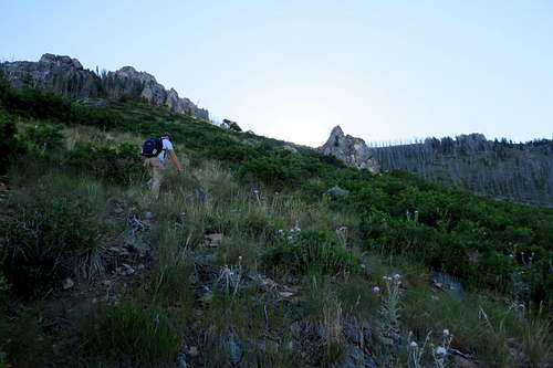
![Dharma Peak: Preston Canyon]() As the route ascends, you will work further north to mouth of Preston Canyon. The track we followed was from wasatchhiker.com, which offered a .kml file for download (thank you!). The track posted here is our actual track, which varried in places from wasatchhiker, but not necessarily as an improvement. The route involves a LOT of bushwhacking on steep grade.
As the route ascends, you will work further north to mouth of Preston Canyon. The track we followed was from wasatchhiker.com, which offered a .kml file for download (thank you!). The track posted here is our actual track, which varried in places from wasatchhiker, but not necessarily as an improvement. The route involves a LOT of bushwhacking on steep grade.
![Preston Canyon Crossing]() After you fully enter the canyon, you must cross the gully. This was some of the roughest scrambling and bushwhacking. You have to drop down very sharply, and then scramble up the other side. It was even worse on the way back. We aimed for a prominent stone that splits the gully. In fact, the gully splits and we followed the middle section up towards the distant upper ridge. That landmark rock is visible in the panorama above. (waypoint "Creek")
After you fully enter the canyon, you must cross the gully. This was some of the roughest scrambling and bushwhacking. You have to drop down very sharply, and then scramble up the other side. It was even worse on the way back. We aimed for a prominent stone that splits the gully. In fact, the gully splits and we followed the middle section up towards the distant upper ridge. That landmark rock is visible in the panorama above. (waypoint "Creek")
![Upper Preston Canyon]() Once you are out of the gully, the bushwhacking is not as intense, but it is relentless. The cone-shaped rock jutting up just right of middle marks about 1/2 way in elevation gain to the ridgeline(waypoint "the rock").
Once you are out of the gully, the bushwhacking is not as intense, but it is relentless. The cone-shaped rock jutting up just right of middle marks about 1/2 way in elevation gain to the ridgeline(waypoint "the rock").
![Preston Canyon Timber]()
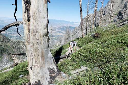
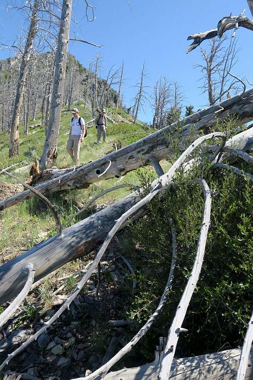
As you climb higher, you enter the burn zone of an old fire. This means lots of log hopping. As you climb, Utah lake will become fully visible. Mt. Mahogony will loom above the Preston canyon ridgeline.
![Mt. Dharma Ridgeline]()
Once you reach the ridgeline, the route down to the arch is fairly passable. The arch is hidden in a rocky fin that juts out of the ridgeline as it generally levels out.
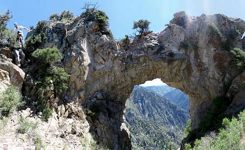
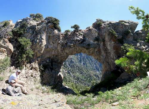
![Devil's Eye Arch as it faces American Fork Canyon]() The arch was easier to find from the American Fork side. The view is not ideal as rocky cliffs keep you far below. The exposure is also a lot worse on the AF side. We had to double back to hunt out the view from the Preston Canyon Side.
The arch was easier to find from the American Fork side. The view is not ideal as rocky cliffs keep you far below. The exposure is also a lot worse on the AF side. We had to double back to hunt out the view from the Preston Canyon Side.
![Devils Eye Arch]() To access the arch, we climbed up the back of the rocky fin and came down a slanted crack on the Preston canyon side. To take this photo, my back is leaning against a rocky ledge, and on the other side of that ledge is a sharp drop off. Since you cannot back up much, you will need a wide-angle lens or panorama to capture the full arch. If you approach the arch from below, while following the base of the fin on the Preston Canyon side, you will walk right past it without finding it (or at least we did).
To access the arch, we climbed up the back of the rocky fin and came down a slanted crack on the Preston canyon side. To take this photo, my back is leaning against a rocky ledge, and on the other side of that ledge is a sharp drop off. Since you cannot back up much, you will need a wide-angle lens or panorama to capture the full arch. If you approach the arch from below, while following the base of the fin on the Preston Canyon side, you will walk right past it without finding it (or at least we did).
![Devils Eye Arch II]() The arch is really impressive, and we didn't see any other traffic all day. And we literally hiked all day to go about 5 miles on this hike. Slow going, but a really neat destination.
The arch is really impressive, and we didn't see any other traffic all day. And we literally hiked all day to go about 5 miles on this hike. Slow going, but a really neat destination.
![Ridge to Dharma]() Dharma (aka Willow Canyon Peak) is in plain view from the arch. In this shot, we have just exited the platform where you can view the arch. The route then follows the ridge line, favoring the less exposed Preston canyon side.
Dharma (aka Willow Canyon Peak) is in plain view from the arch. In this shot, we have just exited the platform where you can view the arch. The route then follows the ridge line, favoring the less exposed Preston canyon side.
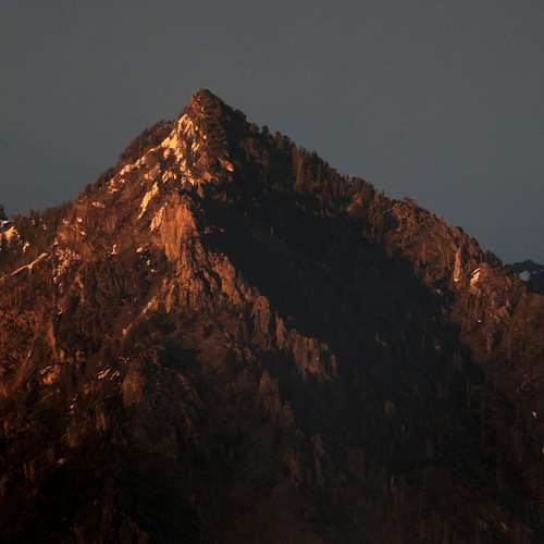
![Dharma / Willow Peak]() Dharma / Willow Peak as seen the fall before this hike. The summit is fairly accessible from the ridgeline to the south. The North side has a lot of cliffs and exposure.
Dharma / Willow Peak as seen the fall before this hike. The summit is fairly accessible from the ridgeline to the south. The North side has a lot of cliffs and exposure.
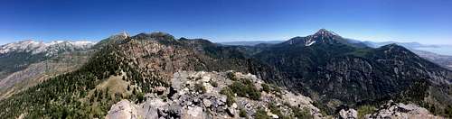
![Dharma Panorama]() From the summit, you can see North Timp, Lone Peak, Pfeiferhorn, and Box Elder
From the summit, you can see North Timp, Lone Peak, Pfeiferhorn, and Box Elder
![Descending Dharma]() Descending Dharma is a rough job. And it is easier to lose the route on the descent. We hiked on a hot day in July. We all underestimated our water needs on this hike.
Descending Dharma is a rough job. And it is easier to lose the route on the descent. We hiked on a hot day in July. We all underestimated our water needs on this hike.
Our Stats:
Start time: 5:45 am
End time: 6:47 pm
Elapsed time: 13:01:49
Moving time: 2:29:51
Stopped time: 10:31:48
Average Speed: .47mph
Moving average: 2.4mph
Starting Elevation: 5275 feet
Max Elevation: 9210 feet
Ascent: 4655 feet
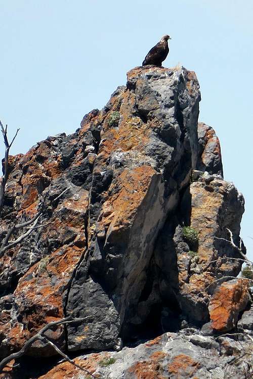
![Golden Eagle]() Golden Eagle
Golden Eagle


Comments
Post a Comment