The Peak
In the Absaroka Range, the largest in area of all the ranges in Greater Yellowstone, there are dozens, perhaps hundreds, of unnamed peaks that have enough prominence to qualify as ranked peaks for those interested in such lists. They also make excellent destinations purely for the sake of climbing. Most of these peaks are far from trailheads, difficult or impossible to see from roads, and seldom climbed. It is quite possible that many of them have never been climbed at all.
The Kirwin area alone has several such peaks. Peak 12,327 is perhaps the most remote of those within a reasonable day trip from the trailhead at Kirwin. And make no mistake that this is a remote peak. Kirwin is 34 miles from the nearest town, Meeteetse, and reached by a rugged 4wd road involving at least three water crossings. From Kirwin, it is over six miles to the summit of Peak 12,327.
The peak is on the boundary of the Washakie Wilderness. On the wilderness side of the boundary is some of the wildest country in the Lower 48. Most people heading deep into it do it on horseback due to the long distances and the often-difficult stream crossings. From the peak’s summit, describing the view as including an “ocean of mountains” is entirely appropriate.
From the summit of
Dollar Mountain in 2010, I became fascinated by Peak 12,327 and was determined to return and climb it in 2011. Also, I was interested in its neighbor, a tepee-like summit that also has no name and that even lacks an officially recorded elevation. I call it Peak 12,300 because its summit lies between the 12,280 and 12,320 contours. According to my GPS device, the elevation is 12,296', but we know that readings can fluctuate slightly depending on atmospheric conditions. Anyway, Peak 12,300 must be climbed along the way if one uses any reasonable approach from Kirwin. It lacks the prominence on all sides to qualify as a ranked peak, but it has a fun little summit block that is worth climbing.
Although Peak 12,327 is remote, unnamed, and farther from the trailhead than any of the named peaks in the Kirwin area, peaks that would naturally draw the majority of the attention, I am not claiming a first ascent despite the fact that the peak also showed no signs of recent human presence-- no register, no cairn, no footprints or other markings, no litter. (There are trails out here, but they were most likely created by the elk and bighorn sheep that roam these mountains in great numbers.) Because the mountain is not technically difficult to climb (just a little Class 3 at the end), because someone could reach the summit in under three hours from Kirwin, because of the prospecting history around Kirwin, and because a backpacking trail (the Absaroka Trail) passes within a mile and 1000 vertical feet from the summit on its west side, it is highly unlikely that this peak, obscure as it is, was unclimbed before I ascended it on August 11, 2011. Nevertheless, it has probably been climbed very, very infrequently.
Some people don't like the fact that pictures displayed on an SP page can give away all the views and spoil the "discovery" for them. With that in mind, I've left the photos of the views in the gallery without displaying them on the main page.
My suggested name for this peak, until it is given an official one or I learn of a locally accepted unofficial one, is Steercalf Mountain because the sources of Steer Creek and Calf Creek are on its slopes. A joking name that SP member musicman82 and I have for the peak is Not-Burwell, in reference to our debate in 2010 over whether the peak is the Mount Burwell of the USGS Mount Burwell quad. It is not, and I was on the losing side of that debate until realizing and admitting my error.
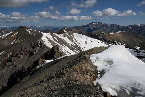
![Summit View-- North]() Peaks 12,327 and 12,300 seen from Dollar Mountain. Click on image for caption information and then click again for better detail.
Peaks 12,327 and 12,300 seen from Dollar Mountain. Click on image for caption information and then click again for better detail.
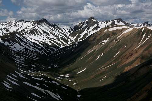
![Wild Absarokas]() Peaks 12,300 and 12,327 seen from the traverse between Chief Mountain and Brown Mountain. Click on image for caption information and then click again for better detail.
Peaks 12,300 and 12,327 seen from the traverse between Chief Mountain and Brown Mountain. Click on image for caption information and then click again for better detail.The Route
The USGS Dunrud Peak and Francs Peak quads will be most helpful. Although Peak 12,327 is not on either quad, it is so close to the edge of the Francs Peak quad that it probably isn’t worth getting the Mount Burwell Quad. Mapping software may work just as well, but I have a preference for the large USGS quads.
From Kirwin at 9200’, hike 1.6 mi up the valley of Wood River to a trail junction just beyond a fence and at about 9600’. A sign indicates the way to Horse Creek. Bear right onto the trail and make a steep ascent into the beautiful alpine valley of Horse Creek. This, in my opinion, is the most beautiful of the drainages that trails from Kirwin access. The very steep section ends at about 10,000’, right around timberline, and although the trail continues to climb the rest of the way, it is never very steep again until the very end when it has to gain the divide between Horse Creek and Yellow Creek.
For a while above timberline, the trail is easy to see and follow, but after it crosses to the right side of Horse Creek, get used to seeing it disappear. It is no great matter, though, for it is easy to tell the way. At a major fork at almost 10,800’, where the main branch of Horse Creek bends so that the flow is from the west, cross the stream again and ascend west roughly parallel to the stream. The trail becomes easy to see again higher up, and although the map shows the trail turning north to gain the aforementioned divide between Horse Creek and Yellow Creek just east of Peak 12,300, I found that the trail instead took me to the 11,460’ saddle just west of 11,867, which does not have enough prominence from its saddle with Mount Crosby to qualify as a ranked peak.
Now head west along the ridge, climbing a minor summit that has a short drop on its other side before the ridge reaches the summit of Peak 12,300. While it’s not necessary to climb the summit block, one should not skip it. The outcrop that is the highpoint is small and precarious-looking, but it’s an easy scramble and makes a great perch for a few minutes.
From this peak, drop a little over 300’ to the saddle between it and Peak 12,327. Follow a sheep trail up to the cliffs and then make an easy scramble through a break in the cliffs to gain the summit. The shape of the mountain suggests that the summit is long and broad like an athletic field, but the actual highest ridge of rock is smaller than it appears to be from afar. While it is not airy the way that the highpoint of Peak 12,300 is, it does not disappoint. If you look carefully, you may find a little memento I left behind. A rare exception to my rule of not leaving human traces on summits, it has sentimental value, so please leave it be. It's there for someone else to find.
Per GPS, it is 4.8 miles from Kirwin to the divide between Horse Creek and Yellow Creek and 1.3 mi from there to the summit of Peak 12,327. Trailhead-to-summit elevation gain is about 3100’, but bumps and Peak 12,300 probably make it closer to 3500’.
Comments
No comments posted yet.