
-
 19674 Hits
-
 83.69% Score
-
 17 Votes
|
|
Route |
|---|---|
|
|
35.23780°N / 106.4623°W |
|
|
Hiking, Mountaineering, Scrambling |
|
|
Spring, Summer, Fall, Winter |
|
|
Most of a day |
|
|
5.0 (YDS) |
|
|
4th class (exposure!) |
|
|
Overview
 The Knife Edge of the Shield
The Knife Edge of the Shield is one of the classic climbs in New Mexico.
The standard approach is from Piedra Lisa Trailhead. The Shield is open to climbing from mid August trough February to peregrine falcons, but the Knife Edge is open year round as mentioned above. Most of the route is 4th class, around the "W" and above it is a short section of 5.2-5.3 climbing.
Some people free solo it, we opted to carry a rope with us, and use it only in the W - less than 10 meter section. We descended via La Luz trail. There are shorter descends, but those were closed for falcon protection and require bushwhacking.
Getting There
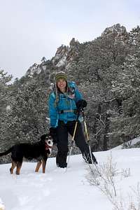 Piedra Lisa Trail
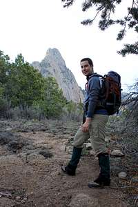 SP member Dave on approach
The standard approach is from La Piedra Lisa Trailhead. To find the trailhead take Tramway Boulevard north; about a mile north of the turn-off to the Tram, turn east on FR 333 (same as for La Luz Trailhead). After about 2 miles, where FR 333 takes a hard right through a stone gate, continue straight ahead on FR 333D, which becomes a dirt road. It is a very short distance along a narrow bumpy road to the trailhead parking lot.
The hike up Piedra Lisa Trail is very pretty. There are nice views of the green canyons on both sides of the trail, as it travels up the ridge line. Piedra Lisa Trail gets a little steep shortly before reaching the top of the ridge line that runs east-west. Two sign poles mark the top of the ridge, pointing the way for the continuation of Piedra Lisa Trail to the north. This ridge is called he Rincon (Spanish for "corner"). A seldom- traveled path, Rincon Spur trail bisects Piedra Lisa Trail at this point and runs along the ridge. Rincon Spur Trail takes you to the base of The Knife Edge of the Shield.
Fee: 3$ at the trailhead (self pay station, rangers come and check often; locals do not have to pay if they bought Sandia Year Pass).
Elevation at the Trailhead:6,929 feet
Route Description
 Climb above "W"
 Approaching "W"
This route follows the ridge, which is pretty narrow at some sections. There is a lot of exposure. The initial sections are easy scramble - 4th class. An entertaining outing with spectacular views. The easy climbing goes fast till the prominent "W" midway up the route. To avoid lowering oneself own these notches, down climb to the left, then back up the ridge. (I believe I down climbed on the right - it was very exposed, a fall would be fatal. I have also seen You Tube video of people jumping the W section onto an exposed rock!). This "W" section and the next 50 meters are very exposed, low 5th class climbing, and again do I have to mention a serious fall potential. Many parties bring a rope for this section. The rest of the route is obvious and easy to follow. The ridge is so narrow, so can't get lost.
Descent: We opted to hike up along the Sandia Crest and descent via La Luz Trail.
Sandia Rock guide book says that the only rational way to descend the Shield after a long day is to hike back to the Crest. From the top of the formation follow game trails southeast, through the limestone band to North Sandia Peak, and eventually to the North Crest Trail. From the Crest, descent via car (long drive from this parking lot back to Piedra Lisa Trailhead, about 50 to 60 min), via trail (La Luz), or the tram.
Other options are available: descend the Knife Edge or rappel from the far southeast end of the wall (only during permitted times, do not disrupt nesting raptors). Do not attempt the latter if unfamiliar with the area. It is so easy to get lost there.
Essential Gear
 Consider rope and some rock protection
 Good comfy shoes
Good hiking shoes/boots, some people bring rock shoes for the climbing section (I did not find that necessary).
Consider rope and some simple rock protection (a couple of cams/nuts - I think we brought a little too much), harness ? We had no helmets, but again loose rock is always a consideration.
A lot of water. You can refill your water bottles at the tram station for free.
Money - if planning to take the tram back down.