
|
|
Mountain/Rock |
|---|---|
|
|
33.36812°N / 105.97485°W |
|
|
Otero |
|
|
Hiking, Mixed |
|
|
Spring, Summer, Fall, Winter |
|
|
6135 ft / 1870 m |
|
|
Overview
The Palisades are a series of cliff tops in the Godfrey Hills of Otero County, New Mexico. The Palisades lie in between two notable destinations - the Three Rivers Petroglyphs and Sierra Blanca and the Sacramento Mountains, just 10 miles away. The Palisades are the south summit of the Godfrey Hills which extend north another 8 miles and crest above 7,000'.
The Palisades would probably go unnoticed if it weren't for two things:
1) The Petroglyphs; and
2) The Santo Niño De Atocha Catholic Chapel, a small church that draws up to 100 worshipers from far away towns for weekend services.
If you step inside this church, you will see the beautiful setup they have. If you walk down the road you will find something else that is special: Several of the cliffs of the Palisades are adorned with crosses. Along the pathway, the Stations of the Cross are symbolized with numerous stone structures that follow a trail up to one of the higher clifftops. From there, you can hike to the higher cliffs in the area.
While the hike up to the top is short, the views are tremendous. This is a wonderful place to hike when the forests are ablaze during fire season.
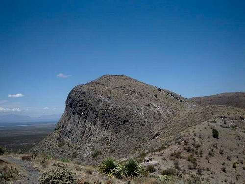 Point 6135
Getting There
From Carrizozo to the North take route 54 South for about 27 miles and turn at the the sign for Three Rivers to the left.
From Alamogordo to the South take route 54 North for about 30 miles and turn at the the sign for Three Rivers to the right.
Once on the road follow it past the petroglyphs site. You will drive about 7 miles until the road becomes private. Right before you hit the private road, you take a right at a sign noting the Chapel. I would advise going to the Chapel and asking if you can hike. There shouldn't be a problem, but you want to respect the land, and let them know you are parking there. The people there are very nice and happy to welcome hikers.
Along the road is a sign for the Stations of the Cross Trail. This trail follows stone pillars down a dirt road, and then a thin trail. The trail heads up towards the cliffs. At the end of the trail you hit a ridge. Go left and you reach the top of the Stations of the Cross Trail and a big cross with other information and great views of Sierra Blanca. The highest point (Point 6135) requires you head back down to the ridge to the closest summit to the church.
Overall this trail climbs about ~850 feet in just over 1 mile to Point 6135. However, to get to the Godfrey Hills South summit (6,254'), you'd need to walk along the crest heading northwest for another 2 miles without a trail. For that summit, you can also park three miles west of the Church at the Three Rivers Petroglyph site.
If you want to visit the highest summits in the Godfrey Hills, Rose Peak 7,126' can be approached from the church if staying on Chapel Road and then heading north into the hills and entering Lincoln County. The highest summit in the range, Godfrey Peak 7,204' must be approached from the 54 Highway near Oscuro via the A002 Road to Grand Blvd.
Red Tape
No red tape or permits required. Bring LOTS of water as the climate is very arid.
Views from the summit

View Southeast

View East

View North

View West
Information on the Petroglyphs
The Petroglyphs are ancient rocks painted by Jornada Mogollon people from 600 to 1100 years ago.
For more info on the Petroglyphs see these sites:
#1
#2
#3