
|
|
Mountain/Rock |
|---|---|
|
|
43.99311°N / 115.10346°W |
|
|
Hiking, Trad Climbing, Sport Climbing, Aid Climbing, Scrambling |
|
|
Summer |
|
|
9970 ft / 3039 m |
|
|
Deep in the Heart of the Sawtooth Mountains
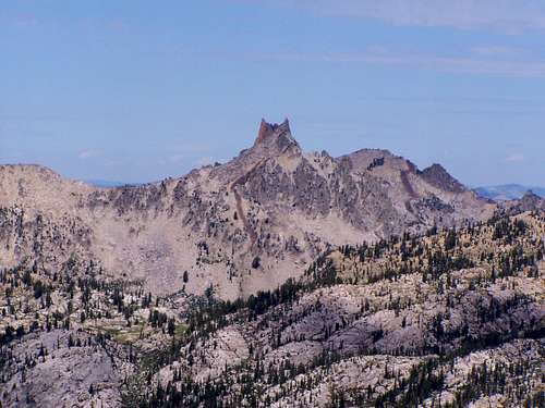 The Rakers from the south east
The Rakers are some of the most unique and remote peaks in the Sawtooth Mountains and consist of the North Raker, a 9,970 ft. high class A2 summit and the South Raker, a 9,880 ft. class 4 summit. Visible from many summits within the Sawtooth Mountain range, the Rakers often appear as fangs jutting up from the Earth off in the distance. And off in the distance they are, approximately 17 miles from the nearest trailhead and 2-3 miles from the nearest trail. Since there is no direct trail to these peaks, cross country travel is required for those seeking the summit. Due to the lengthy and difficult approach, these peaks see very few summits per year and typically require a multi-night trip.
 The Rakers saddle view
USGS Quad Confusion
The USGS Mount Everly quad has the North Raker appearing as a peak with 2 summits, one at 9,970 and another at 9,880 and lists a smaller peak to the south as the "South Raker". This can lead to some confusion. Anyone viewing the Rakers from other Sawtooth summits can identify two obvious summits. These are know as the North Raker and the South Raker. Although there is a "South Raker" identified on the Mount Everly quad, climbers have always regarded the North Raker's north summit as the North Raker and the south summit, the South Raker. North Raker (Red Finger) North Raker (Red Finger) |  USGS "South Raker" on the left USGS "South Raker" on the left | 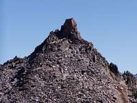 South Raker South Raker |
Appropriately Named
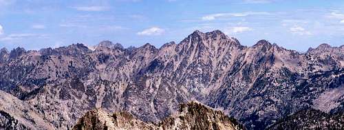
The rakers get their name from the raker teeth on a cross cut saw. Forest Service map maker Arval Anderson was the man responsible for naming the peaks, and you can see why he chose such an appropriate name. Thanks to Super Dave for pointing out this bit of history. Raker tooth saw blade Raker tooth saw blade |  As seen from Williams Peak - Warbonnet in foreground As seen from Williams Peak - Warbonnet in foreground |
Getting There
THE NORTHERN APPROACH Blacknose Mountain as seen via Southern Approach
The typical approach is via the Grandjean Trailhead. Take Idaho Highway 21 north about 25 miles past Lowman. Follow the sign for Sawtooth Lodge and turn right on a dirt road. Continue down this road for 6 mile to Grandjean where you will take a left to the hiker's/backpacker's trailhead.
Hike the Grandjean trail for 1.5 miles until you reach the fork for Baron Creek and the South Fork of the Payette. Take the right fork and hike along the South Fork of the Payette for another 12 miles until you pass Elk Lake. From here, whip out your map and dial in your cross country route finding skills. You'll need to cross the South Fork of the Payette and head south up the Fall Creek drainage. Let your route finding take you up the drainage up to the saddle between the peaks. Anyone with direct knowledge this approach, feel free add a route to this page describing the approach.
Info from bk: Ascend from the south end of elk lake keeping right of the main drainage and diagonalling up to the head of Fall Creek Valley. Once in the valley, continue across the meadow keeping to the right side. Once you enter the trees continue on the faint old trail until you see the bare rocky patch on the hillside on your left, begin ascending here diagonalling to the left (there are good ramparts). you should reach the first lake in about 2 miles from starting up.
THE SOUTHERN APPROACH
 Lake 8696 near the top of the Queens River Loop. Nice spot to camp.
Another approach to The Rakers is from the south and the Queens River/ Little Queens River loop. This loop is a fantastic trip in and of its self and lets you gain access to many other lakes and peak bagging opportunities along the way and the way back. Take Idaho Highway 21 north of Idaho City about 18 miles and turn east at the sign for Edna Creek Campground onto FR 384. From here, follow signs to Atlanta. At 13.7 miles turn left (east) onto the North Fork of the Boise River road (FSR 327). At 26.6 miles turn left at a 4 way stop onto the Middle Fork of the Boise River road (FSR 268). At 36.5 miles turn left onto the Queens River road (FSR 206) and drive another 2.5 miles to the trailhead at 39 miles. From here, hike up the queens river trail until it tops out at 9200 feet just above Arrowhead Lake. Follow the Queens River Route from here.
Camping
Since you'll most likely be backpacking, camping is often best at a nearby lake. From the north, Elk Lake is a logical spot to set up camp, and from the south, any of the many lakes along the Queens River loop would make for a great spot to camp.[img:737458:aligncenter:medium:Lake 8696 near the top of the Queens River Loop. Nice spot to camp.]
bk - Sep 23, 2011 4:31 pm - Hasn't voted
approach from Fall Creekascend from the south end of elk lake keeping right of the main drainage and diagonalling up to the head of Fall Creek Valley. Once in the valley, continue across the meadow keeping to the right side. Once you enter the trees continue on the faint old trail until you see the bare rocky patch on the hillside on your left, begin ascending here diagonalling to the left (there are good ramparts). you should reach the first lake in about 2 miles from starting up.
Super Dave - Dec 2, 2011 12:21 am - Voted 10/10
Name HistoryThe Rakers were given their name in 1927 by Forest Service map maker Arval Anderson because they resembled the raker teeth on a cross-cut saw.