Introduction
While the Caribbean is usually thought of being full of cruise ship passengers and other run of the mill tourists, it does have a wild side. Luckily, the stereotypical luxury cruise ship tourists tend to gather at the casinos and shopping centers, rarely venturing more than a few miles from port.
Yet in the Caribbean, beyond the casinos and shopping centers lies a lost world of spectacular waterfalls, virgin rainforest, beautiful mountains, hidden beaches, rugged coastlines and hidden ruins. This is the story of a trip to two Caribbean Islands (Puerto Rico and Dominica) that I took with my seven year old daughter Shaylee (we needed some Daddy-daughter time) between December 20 2011 and January 6 2012. On this trip we climbed several steep and spectacular mountains, taking on some of the Caribbean’s toughest hikes and ascents (especially on Dominica); swam, climbed and rappelled through subterranean gorges, explored dark rainforest and yes, we even did a lot of tourist stuff too.
Because of the nature of this website, only the more adventurous aspects of the trip will be highlighted on this trip report.
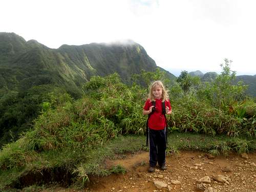
![Summit]() Shaylee on the summit of Morne Nicholls.
Shaylee on the summit of Morne Nicholls.December 21: El Portal Trail/Angelito Trail (Puerto Rico)
After arriving at the San Juan Airport at 3 am we caught some sleep before picking up a rental car and heading to the Caribbean National Forest and the El Yunque area. We were tired and only had some time for some short hikes.
The first hike we did was the El Portal Trail. We completed the loop trail and saw some really big snails and lizards along the way. Shaylee also liked to play with the huge dead leaves on the trail.
After the El Portal Trail, we drove to the Angelito Trail so we could hike it. We hiked down the trail to the beautiful pool at the river and watched the fish swim in the crystal clear pool before heading back up to the trailhead. It was a great day, but we were tired from the previous flight.
![Rio Mameyes]() Shaylee at the pool along the Rio Mameyes.
Shaylee at the pool along the Rio Mameyes.December 22: Big Tree Trail (Puerto Rico)
In the morning Shaylee and I attended the iguana feeding at the hotel and after that we went horseback riding so we only had time for a short hike by the afternoon. We chose to hike the Big Tree Trail in the El Yunque area. We hiked the trail to the Cascada La Mina, a beautiful waterfall.
After enjoying the waterfall we hiked back to the trailhead and on the way back we stopped to check out the Cascada La Coca.
![Iguana]() Iguana at Rio Mar.
Iguana at Rio Mar.![Cascada La Mina]() Cascada La Mina.
Cascada La Mina.December 23: Los Picachos/Pico El Yunque/Roca El Yunque/Monte Britton (Puerto Rico)
Shaylee and I climbed all the points in the El Yunque area today. We started out at the Baño de Oro Trailhead and hiked up the mountain up to the turnoff for Los Picachos. We climbed the side track to Los Picachos where enjoyed the views before heading back to the main trail and climbing up to the summit of Pico El Yunque.
We decided to also climb the Roca El Yunque so we headed west and found the track to the scrambling route up to the summit. We found the Roca El Yunque to have the nicest views of the bunch and the scramble to the summit was fun.
After climbing the Roca we headed towards Monte Britton so we could climb that too. We climbed up the tower on top of the peak and then headed down to the Monte Britton Trail and back to the trailhead. It was a really great hike and with the paved trails, mountains don’t get that much easier in the tropical rainforest. There was some rain, but it wasn’t bad.
![El Yunque]() Hiking up Pico El Yunque in the rain.
Hiking up Pico El Yunque in the rain.![Windy!]() Shaylee on the summit of Los Picachos in windy conditions.
Shaylee on the summit of Los Picachos in windy conditions.![Climbing Roca El Yunque]() Shaylee climbing Roca El Yunque.
Shaylee climbing Roca El Yunque.December 24: El Toro/La Coca Trail (Puerto Rico)
Shaylee and I left for a climb of El Toro in Caribbean National Forest near El Yunque. It had rained hard the night before and the trail was extremely muddy. The trail isn’t used that much and there were some big washouts that we had to bushwhack around. Because of all of the deep mud, Shaylee said that she wanted to try another trail. We hiked back to the trailhead and drove to the La Coca Trail, which was the last trail we hadn’t hiked in the El Yunque area.
We found the La Coca Trail to be just as muddy as the trail to El Toro, but we persevered anyway. We hiked down across the river and continued along the muddy trail to a nice waterfall. After enjoying the waterfall we hiked back up the muddy road to the trailhead. After reaching the trailhead we found that the trail was barricaded and closed for “dangerous conditions” (it wasn’t closed when we started the hike). It wasn’t dangerous, but it was extremely muddy.
![Giant snail]() One of the giant snails as seen on the route to El Toro.
One of the giant snails as seen on the route to El Toro.![Fighting through logs]() Fighting through the mud and logs along La Coca Trail.
Fighting through the mud and logs along La Coca Trail.December 25: Lower Micotrin (Dominica)
Today I took a late evening hike up the concrete road towards Freshwater Lake to the lower slopes of Micotrin to orientate myself to the area and to look for the routes up Micotrin (I was just looking for the beginning of the route, not looking to climb the peak yet). It was getting dark and I didn’t find the main route before I had to head back down. After it got dark, there were many jumping glowing bugs all over the ground.
![Morne Micotrin]() The lower slopes of Micotrin.
The lower slopes of Micotrin.![Roxy s]() Roxy's place is where we stayed December 25-30.
Roxy's place is where we stayed December 25-30.December 26: Boeri Lake/Freshwater Lake/Trafalgar Falls (Dominica)
Shaylee and I had a long, but spectacular day. First we hiked all the way from Laudat to the Boeri Lake Trailhead. After that we made the nice hike up to the scenic Boeri Lake. After resting at the lake and admiring the views and watching the clouds and mist swirl around the nearby peaks, we headed back down to Freshwater Lake. We hiked around the lake and climbed a peak to the southeast of the lake. After enjoying the lake we hiked back down the road a short distance where we got a ride to near the Trafalgar turnoff.
After chatting with one of the guides at Extreme Dominica (whom we were to go canyoning with the next day) we got a ride to near the Trafalgar Falls Trailhead. We hiked to the spectacular waterfalls and climbed up to them. After enjoying the two falls we headed back to Trafalgar and started walking to the main highway. We tried in vain to get a ride back up to Laudat so we walked most of the way back to Laudat before finally getting a ride. It was a very spectacular, but long day!
![Crossing the creek]() Crossing the creek near Boeri Lake.
Crossing the creek near Boeri Lake.![Boeri Lake]() The beautiful Boeri Lake.
The beautiful Boeri Lake.![Trois Pitons]() The slopes of Trois Pitons as seen from Boeri Lake.
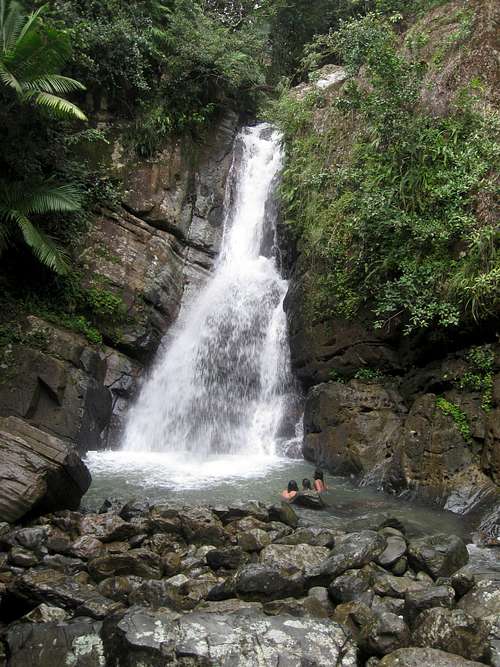
The slopes of Trois Pitons as seen from Boeri Lake.![Trafalgar Falls]() Trafalgar Falls.
Trafalgar Falls.December 27: Lower Titou Gorge to Trafalgar Falls (Dominica)
Today Shaylee and I went canyoneering. We walked part way down to Trafalgar before getting a ride to the Trafalgar turnoff where we walked to the canyoning office near Cocoa Cottages. After some practice rappels our group headed off to the gorge near Laudat that is below the more well known Titou Gorge. We rappelled down several waterfalls and swam many crystal clear pools while heading deeper into the gorge. It sure was a spectacular slot canyon. Shaylee had a great time and she got to rappel several times without being lowered.
We exited the canyon just above Trafalgar Falls (which takes very long ropes to negotiate). It was a great canyon and a great day.
![Rap]() Shaylee rapping into the lower Titou Gorge.
Shaylee rapping into the lower Titou Gorge.December 28: Morne Nicholls/Valley of Desolation/Boiling Lake (Dominica)
Shaylee and I went for a hike over the top of Morne Nicholls to the Valley of Desolation and Boiling Lake. We started out with two other people who invited us along and who were using a guide, but it was quickly obvious that they were moving rather slowly, so we gave them some money and just went on by ourselves. We passed three other guided groups along the way to Mount Nicholls. We enjoyed the spectacular views from the summit and the weather was great.
The route to Morne Nicholls and to Boiling Lake is actually well marked and the horror stories about the difficulty of the hike are much exaggerated. The hike is steep in places with some minor scrambling and many stairs, but it only took us 2 hours 31 minutes to reach Boiling Lake (Shaylee is seven years old). The walk through the Valley of Desolation was spectacular. Below the Valley of Desolation were many turquoise colored pools and waterfalls.
At last we found ourselves at the final scramble and we hiked up to Boiling Lake just in time to eat a nice lunch and to watch the lake boil. It was quite a sight to behold.
After hanging out at the Boiling Lake for an hour, we headed back down, meeting the group we started with at the bottom of the last scramble. They had given up and were headed back down. We passed them and rather quickly made our way back up to the top of Morne Nicholls. After passing two more groups we made our way down to the trailhead and then took the long way to Roxy’s so we could stop and buy ice cream at the small store in Laudat. The hike to Morne Nicholls, Valley of Desolation and Boiling Lake was one of the highlights of our trip.
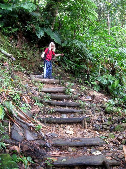
![Near the Trailhead]() Just before the trailhead is this bridge.
Just before the trailhead is this bridge.![Typical Trail]() This is a typical section of the trail to Morne Nicholls. The trail is well constructed and has many log steps.
This is a typical section of the trail to Morne Nicholls. The trail is well constructed and has many log steps.![Morne Nicholls]() Morne Nicholls is to the right. As seen from pretty close to the summit.
Morne Nicholls is to the right. As seen from pretty close to the summit.![Rock Scramble]() Rock scrambling just over Morne Nicholls.
Rock scrambling just over Morne Nicholls.![Morne Nicholls]() Morne Nicholls as seen from the Valley of Desolation.
Morne Nicholls as seen from the Valley of Desolation.![Valley of Desolation]() The Valley of Desolation with all its bubbling hot springs, geysers and steam vents.
The Valley of Desolation with all its bubbling hot springs, geysers and steam vents.![Scramble]() One of the scrambles on the way to Boiling Lake.
One of the scrambles on the way to Boiling Lake.![Rock Scramble]() A short root and rock scramble en-route to Boiling Lake.
A short root and rock scramble en-route to Boiling Lake.![Boiling Lake]() Boiling Lake. The lake really is boiling and is the largest boiling lake in the world.
Boiling Lake. The lake really is boiling and is the largest boiling lake in the world.![Valley of Desolation]() Another shot of the geysers and hot springs as seen on the way out.
Another shot of the geysers and hot springs as seen on the way out.December 29: Titou Gorge/Middleham Falls (Dominica)
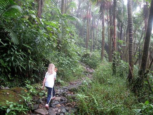
In the morning, Shaylee and I walked to the Rainforest Arial Tram from Roxy’s in Laudat. We wanted to see if Shaylee could do the zipline across the Breakfast Gorge, but they said that she was too young. We then walked to the Titou Gorge to poke around before walking the road all the way to the Middleham Falls Trailhead. We did the hike to the falls and then all the way back to Roxy’s, sometimes in pouring rain.
![Middleham Falls]() Middleham Falls. Because the falls is so high, it's nearly impossible to get it all in one picture!
Middleham Falls. Because the falls is so high, it's nearly impossible to get it all in one picture!![Middleham Falls]() The beautiful Middleham Falls.
The beautiful Middleham Falls.![Hiking in the rain]() Hiking back from Middleham Falls after a heavy downpour.
Hiking back from Middleham Falls after a heavy downpour.December 30: Morne Bruce (Dominica)
After 10 days of steady hikes and climbs, it was time for an easier day. Today Shaylee and I walked through the botanical gardens at Roseau before climbing Morne Bruce (which is more a hill than a mountain). We walked the trail known as Jack’s walk to the summit. It was some a nice hike and we saw several huge millipedes along the way.
![Tree]() One of the trees at the base of Morne Bruce.
One of the trees at the base of Morne Bruce.December 31: Morne Trois Piton (Dominica)
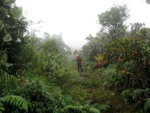
Shaylee and I made a climb of Morne Trois Piton today. Trois Piton turned out to be the most difficult mountain we have climbed on our Dominica/Puerto Rico Trip.
From Roseau we were able to find a bus that would drop us off at Pont Casse. From there we walked the highway to the trail and started up the mountain. A family that lives near the trailhead asked us if we were going to the top and gave us some strange looks when we said yes.
The trail going up is very steep, but there are log steps along the way. Unfortunately some of the logs are quite rotten and the trail is somewhat overgrown, so my legs got really scratched and beat up (I was wearing shorts, but Shaylee was wearing long pants).
We kept waiting for the climb to get easier, but it actually got more difficult the higher we climbed. There were many logs to climb over and some rock scrambles as well. Eventually we found ourselves at the summit, but it was a hard won summit to say the least. It was misty and rainy and we didn’t get any views.
The climb down was more difficult than the climb up. The logs were all incredibly slippery and we both had several falls each. We were also plagued by torrential rainfall. When we (finally) got down the mountain, I was guessing that the torrential rainfall would help us get a sympathy ride back to Roseau, but this was not to be. The driver of one car that stopped said “I would give you a ride, but you guys are all wet”. We started walking down the highway and eventually we got a ride back to Roseau in the back of a pickup.
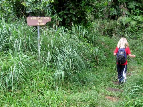
![Trailhead]() This is the trailhead for Trois Pitons. While many of the trailheads have signs stating time needed for a climb, we were able to beat most of the times. Not so for Trois Pitons. It took us much longer than two hours each way.
This is the trailhead for Trois Pitons. While many of the trailheads have signs stating time needed for a climb, we were able to beat most of the times. Not so for Trois Pitons. It took us much longer than two hours each way.![Vegetation]() Some of the interesting vegetation seen on Trois Pitons.
Some of the interesting vegetation seen on Trois Pitons.![Rock Scramble]() One of the many slippery rock scrambles required to climb Trois Piton.
One of the many slippery rock scrambles required to climb Trois Piton.![Easy section of trail]() This is one of the easier sections of the route to Trois Pitons.
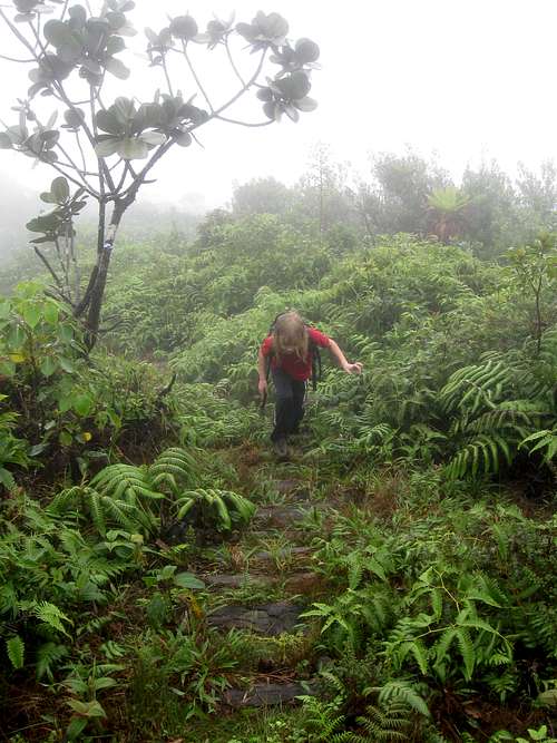
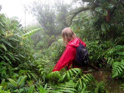
This is one of the easier sections of the route to Trois Pitons.![Pouring rain]() Shaylee climbing Trois Piton in torrential rains on December 31 2011. We had rain gear with us, but since most of the route is steeper than in the photo we found that we got just as wet (from sweat) wearing the raingear as we did without it.
Shaylee climbing Trois Piton in torrential rains on December 31 2011. We had rain gear with us, but since most of the route is steeper than in the photo we found that we got just as wet (from sweat) wearing the raingear as we did without it.![Descending in the Rain]() Shaylee descending Trois Piton in the rain.
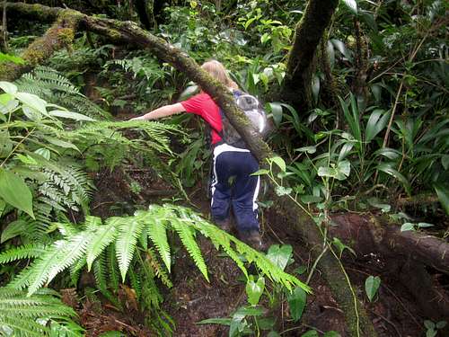
Shaylee descending Trois Piton in the rain.![Overgrown]() An overgrown section of the Trois Pitons trail. Some of the vegetation is sharp, so I got all bloody, but not Shaylee! She was smart and wore long pants.
An overgrown section of the Trois Pitons trail. Some of the vegetation is sharp, so I got all bloody, but not Shaylee! She was smart and wore long pants.![Descending]() Shaylee descending Trois Piton. Trois Piton turned out to be the most difficult mountain that we climbed on our trip to Puerto Rico and Dominica.
Shaylee descending Trois Piton. Trois Piton turned out to be the most difficult mountain that we climbed on our trip to Puerto Rico and Dominica.January 2: West Cabrit/Douglas Bay/East Cabrit/Indian River (Dominica)
Shaylee and I decided to climb the two Cabrits (hill or mountain) and to visit some of the old ruins in the area. We took the bus to near the entrance of the national park and we walked the rest of the way. We hiked to and visited the old Fort Shirley before climbing the West Cabrit. Along the way we saw many hermit crabs and many lizards, which Shaylee liked to watch. The weather was clear and we had some great views from the summit of West Cabrit. There was a cannon on top as well.
After climbing the West Cabrit we walked back down the mountain and then headed north towards Douglas Bay. The ruins at the old battery felt quite mystical since trees and vines had taken over much of the old ruins. After exploring around we backtracked a ways and located the trail up to the summit of the East Cabrit. We saw a snake along the way and the views were really nice. At one point we could see all the way north to the island of Guadeloupe.
After climbing the East Cabrit we walked all the way back to Portsmouth, visiting Purple Turtle Beach along the way. We also took a boat ride up the Indian River and did a short trail around there and saw many land crabs, birds and an iguana.
![Near the trailhead]() A beach near the trailhead and Portsmouth.
A beach near the trailhead and Portsmouth.![Hermit Crab]() Hermit crabs are all over the trails leading to the summit of the Cabrits and are even found close to the summit.
Hermit crabs are all over the trails leading to the summit of the Cabrits and are even found close to the summit.![Summit]() An old cannon (from the 1700's) sits on the summit of West Carbit. It must have been quite a feat to drag up it to the summit!
An old cannon (from the 1700's) sits on the summit of West Carbit. It must have been quite a feat to drag up it to the summit!![Typical Trail]() Typical trail conditions on the Cabrits.
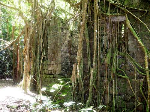
Typical trail conditions on the Cabrits.![Old Ruins]() Part of the old ruins at the Douglas Bay Battery, which are located on the slopes of the Cabrits. This is the old officers quarters from the 1700's.
Part of the old ruins at the Douglas Bay Battery, which are located on the slopes of the Cabrits. This is the old officers quarters from the 1700's.![East Cabrit]() Looking down on Douglas Bay from the slopes of East Cabrit.
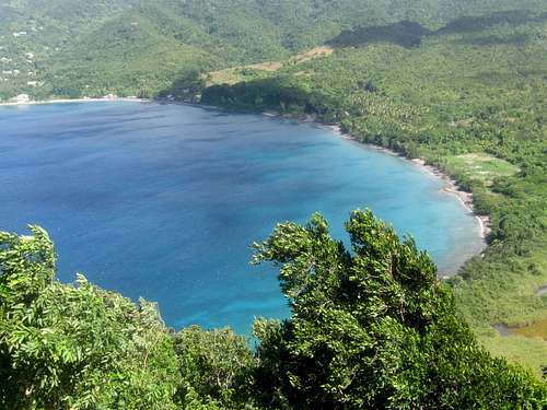
Looking down on Douglas Bay from the slopes of East Cabrit.![Trailhead (for climbing the Cabrits)]() Walking back along the Purple Turtle Beach after climbing the Cabrits.
Walking back along the Purple Turtle Beach after climbing the Cabrits.![Indian River]() Indian River.
Indian River.![Cabrits]() Looking across the Prince Rupert Bay from the south side of Portsmouth. West Cabrit is on the left and East Cabrit is on the right.
Looking across the Prince Rupert Bay from the south side of Portsmouth. West Cabrit is on the left and East Cabrit is on the right.January 3: Morne Diablotin (Dominica)
Today Shaylee and I climbed Morne Diablotin, the highest mountain in Dominica. Some sources say that Diablotin is the toughest climb in Dominica, but we found it to be slightly easier than Trois Piton.
From Portsmouth we took a taxi to the beginning of the trail and asked the taxi driver to pick us up at 4:30 PM from the same location. The trail to Diablotin starts off with a steady grade, but isn’t too difficult. The rain forest in marvelous and we got some quick glimpses of the rare endemic parrots which happen to squawk quite loudly.
Once the ridge is reached, the climb became much more challenging and we were constantly wading through deep mud (sometimes nearly knee-deep) and climbing over roots and logs. This is what is known as a jungle-gym climb because you are often climbing over roots several feet above the ground. There were some slippery rock scrambles as well. The going was quite slow and because of the mist it was quite slippery as well. It was also the muddiest climb that I have ever done.
The weather was mostly misty, but on occasion the sky would partially clear for brief period and at other times there would be heavy rain. After lots of tiring work, we found ourselves at the summit, but we couldn’t see that much because of the mist.
The climb down was as challenging as the climb up and we had to hurry in order to get back to the trailhead by 4:30 PM. We had some torrential rains and Shaylee had a couple falls and got a few bruises.
We made our way down the mountain as quickly as we could, but we missed the 4:30 PM time by seven minutes. When we didn’t see our taxi waiting for us, we walked down the deserted road for over an hour before another taxi picked us up. He knew the other taxi driver that was supposed to pick us up and it sounds like he left for a couple minutes to go get some water and it just happened to be at the exact time when we got to the road and thought he wasn’t coming. Everything worked out fine, but it was a pretty long day.
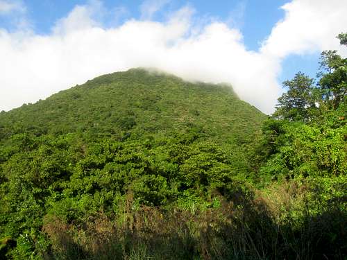
![Diablotin]() This is Diablotin as seen from near the trailhead during a brief period of blue skies.
This is Diablotin as seen from near the trailhead during a brief period of blue skies.![Morne Diablotin]() The slopes of Diablotin from the climbing route.
The slopes of Diablotin from the climbing route.![Climbing]() This is the beginning of the jungle gymn section of the climb up Diablotin.
This is the beginning of the jungle gymn section of the climb up Diablotin.![Diablotin]() Climbing through the roots about 2/3 of the way up Morne Diablotin.
Climbing through the roots about 2/3 of the way up Morne Diablotin.![Climbing Diablotin]() Shaylee climbing Morne Diablotin. The climb is rather challenging and you have wade through mud and climb over many slippery logs and rocks.
Shaylee climbing Morne Diablotin. The climb is rather challenging and you have wade through mud and climb over many slippery logs and rocks.![False Summit]() The summit of Diablotin lies just ahead. This was a rare (and brief)clearing. Most of the time the summit lies in the mist and clouds.
The summit of Diablotin lies just ahead. This was a rare (and brief)clearing. Most of the time the summit lies in the mist and clouds.![Near the summit]() This rock is just short of the summit of Diablotin and was the best place to sit for a well deserved rest.
This rock is just short of the summit of Diablotin and was the best place to sit for a well deserved rest.January 5: Castillo de San Filipe del Morro/La Muralla/Castillo de San Cristobol (Puerto Rico)
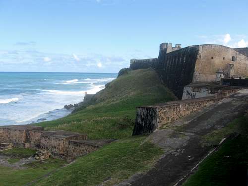
In contrast to most of the other days on our trip, this really wasn’t a wilderness type hike, but Shaylee and I did end up visiting both Castillos and walking the La Muralla and the Paseo de Princesa between the two impressive forts in San Juan. The two forts were started in 1539 and 1634 and took a few hundred years to finish. The Paseo de Princesa is the walking trail at the base of the wall of La Muralla and stretches from one end of Old San Juan to the other. We couldn’t complete the entire path along the coast because parts of it were closed due to big ocean waves crashing over the walls. It took most of the day to complete the trip.
![Castillo de San Cristobol]() This is Castillo de San Cristobol. In contrast to most of the other days on our trip, this really wasn’t a wilderness type hike, but Shaylee and I did end up visiting both Castillos and walking the La Muralla and the Paseo de Princesa between the two impressive forts in San Juan. The two forts were started in 1539 and 1634 and took a few hundred years to finish. The Paseo de Princesa is the walking trail at the base of the wall of La Muralla and stretches from one end of Old San Juan to the other. We couldn’t complete the entire path along the coast because parts of it were closed due to big ocean waves crashing over the walls. It took most of the day to complete the trip.
This is Castillo de San Cristobol. In contrast to most of the other days on our trip, this really wasn’t a wilderness type hike, but Shaylee and I did end up visiting both Castillos and walking the La Muralla and the Paseo de Princesa between the two impressive forts in San Juan. The two forts were started in 1539 and 1634 and took a few hundred years to finish. The Paseo de Princesa is the walking trail at the base of the wall of La Muralla and stretches from one end of Old San Juan to the other. We couldn’t complete the entire path along the coast because parts of it were closed due to big ocean waves crashing over the walls. It took most of the day to complete the trip.


Comments
Post a Comment