
-
 33094 Hits
-
 93.29% Score
-
 42 Votes
|
|
Mountain/Rock |
|---|---|
|
|
47.65579°N / 121.13062°W |
|
|
Scrambling |
|
|
Spring, Summer, Fall |
|
|
6556 ft / 1998 m |
|
|
THUNDER Mountain!
Sounds so loud huh? Well it is not that loud....
Thunder Mountain is a nice little peak tucked in the rugged beautiful Alpine lakes area. It is located NE of Mt. Daniel and Hinman and south of Stevens Pass, right on the Cascade crest. The area is incredible with many scramble and climb options. Most folks will head up into the Trap Pass area to climb Slippery Slab Tower. SST is a fairly popular climb and most don’t go beyond this point.
The views are spectacular from the lakes and the summit.

Daniel, Hinman, Granite ridge, Stuart range, and much more. This area is fragile so please stay on established tracks/trails and camp in established spots! We don’t want this area to start to look like the Chants or the Ramparts.
Route Overview
There are a few different routes one can climb, but the most climbed route is the SE slope from Upper Thunder Lake via Trap Pass.The SE slope can be attained from Thunder lakes area or Square lake. Class 2-3
NF is granite and has 600' of class 5 climbing. Thunder NF was climbed by Bruce Garret and Dennis Nelson on July 6, 1972. (Reference Beckey Guide)
One can take the SE slope from Square lake but the approach is much longer.
Surprise lake to the West ridge is a possible route too. The hike in from the TH is long and forested. You would also add about 800'+' to the gain from this TH.
Getting there
Take SR 2 from Seattle to the hairpin turn (about 5 miles west of Stevens pass). Turn right onto FSR # 6095. Drive about 1.5 miles on good dirt road to a road spur on the left. Pull in and park.From Leavenworth Take SR 2 about 5 miles past Stevens pass to the hairpin turn, passing FS 6095 (on the left) and pulling a U turn to get to the other side of the barrier in the middle of the road. Drive back up SR 2 and take a right onto FSR 6095.
Approaches to Trap Pass
Tunnel Creek trail to PCT trail.Take the Tunnel Creek trail (trail # 1061) for 1.6 miles. The trail ends at Hope lake. From Hope Lake head South on the PCT trail. You hike up switchbacks for about .5+ miles to a saddle and then it levels out a bit. Once you cross the ridge you start to traverse the slope on the south side. You come into a meadow and then the trail basically levels out and traverses for a couple of miles (with great views and meadows) till you start the switchbacks up to trap pass above trap lake.
TH at 3100' Hope lake at 4400' Trap pass around 5800'
5.6 miles to Trap pass on easy trail.
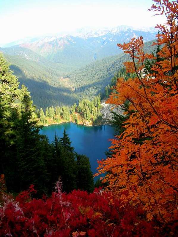
Image taken and used with permission by Tazz.
Surprise Lake trail.
This approach may be a mile shorter but it is an extra 800' or so gain. It's also in the trees for the entire hike. Take Surprise creek trail (#1060) 4 miles to Surprise lake. From Surprise lake turn left on Surprise Creek trail #1060. Ascend many switchbacks to Trap pass.
TH at 2400'
4.6 miles to Trap pass.
camping
What a great area for an overnight-er! Several choices for camping along the entire route.You can camp at Hope lake or Trap lake. Trap lake is incredible and has good views compared to Hope lake.
There are some great spots just past Slippery Slab Tower with some great views. Water might be an issue late in the season.
Thunder Lakes is the best spot to set up camp though. Incredible views of the Stuart range and to the SE. There are some great spots tucked into the granite slabs.
One can also find a good spot up on the ridge and Thunder Pass area. Unless there is snow one would have to drop down to get water from the lakes.
The entire area is full of meadows with fragile plant life. Please be mindful of the fragile meadows and camp/hike on established sites and trails.
when to climb
Spring, summer, and fall are the best options. Fall offers some of the most fabulous color!Winter would provide great skiing. One must be mindful of avalanches. You would have to traverse many avy slopes to get in there.
Trip reports, links and red tape
A NW forest pass is required to park at the trail head. (But probably shouldn't be, given the Forest Service's definition of a trail head.)trip report by Fred Beavon
Gabriel's trip report and site