
|
|
Mountain/Rock |
|---|---|
|
|
35.79685°N / 129.34718°E |
|
|
Hiking |
|
|
2444 ft / 745 m |
|
|
Overview
Forest trail To summit
Tohamsan Peak in and of itself isn’t particularly compelling; it’s is just one of a thousand similar mountains all across Korea; nice trail with thick forest. Tohamsan Mountain, however, has two of the most visited, gotta see sites in the whole of South Korea--Bulguksa Temple and Seokguram Grotto. These two sites are UNSECO approved, strikingly beautiful, and listed in every single tourist book published since 675 AD. You are going to be here anyway, you may as well do the final climb to the top of the hill.
Tohamsan is located in south east ROK near the ancient city of Gyeong-ju. Gyeong-ju was, at one time, one of the world’s great cities with over a million souls and capital of the Silla Kingdom. Once the Silla kings were conquered in 935 A.D., Korea’s capital moved north to Seoul, Gyeong-ju fell into disrepair and was largely abandoned. Forgotten for centuries, the city has become a focal point for both archeologists and tourists since the mid-1960s. Two of the most studied and visited sites, Bulguksa Temple and Seokguram Grotto, are located in the mountains south-east of the city. Bulguksa is on the lower part of the mountain and Seokguram located higher up the hill. Until the mid-2000s, reaching Seokguram involved hiking about 3 kilometers up the hillside from Bulguksa on a steep forest trail (which is still there). Since then, they have built a parking lot about .5k from Seokguram. The trailhead to climb Tohamsan Summit is located just off Seokguram parking lot right behind the Seokguram ticket booth. A sign points the direction.
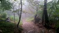
Tohamsan is a 745 meter peak (2,444 feet) about 1.4k hike from the Seokguram parking lot trailhead. Tohamsan literally translates to “Big East Mountain” (“san” means mountain in Korean). The trail to the top is straight forward and, once you’ve found the trailhead, has no unsigned deviations. The signage is clearly marked in both English and Korean. The trail itself is well maintained, easy to follow and suitable for hikers of all skill levels (it is steep for out-of-shape, casual hikers—Koreans don’t seem to believe in switch backs). The trail is heavily forested along the route. The views along the route are especially pretty with the maple leaf changes during the fall. Rain is a double edged sword, it limits the views but also keeps the crowds down. In any event, very few of the tourists climb Tohamsan so a tranquil split off is usually welcomed during a hard tourist day.
Tohamsan’s summit is marked by a large monolith and a couple of information signs. The info signs give you distances to a couple of alternate trailheads, route maps and a “point tour” of other visible points of interest visible from the summit. There is a helicopter pad about 50 yards below the summit. Caution signs with cartoon moon bears (talk about surreal) warn you to stay off the mountain top during lightening and other poor conditions. Other signs along the route tell you what to tell the rescuers for location in case of a heart attack or need of emergency services.

Helicopter Pad on route
Tohamsan, Seokguram and Bulguksa are all located in Gyeong-Ju National park. That is sort of a misnomer as the entire area, including the Gyeong-Ju City are considered National Park (due to the area’s historical significance). The two points of interest that put you on Tohamsan Mountain are Seokguram Grotto and Bulguksa Temple.
Bulguksa Temple, originally built 528 (Silla Kingdom era), burnt by the Japanese 1597, rebuilt 1604, and rebuilt again in the 1960s, is listed as an UNESCO item. It consists of a series of highly ornate buildings on stone foundations and houses. Bulguksa becomes more of a tourist attraction and less of a place for peace as it frequently gets crowded with tour buses. There is a 2.2 km trail from the temple to Seokguram Grotto which up until around 2008 (when they built the road to Seokguram), was the primary route. You can still use this route if you want to extend your hike. Hiking from Bulguksa Temple to Tohamsan Summit is 3.6 km.
Seokguram (built in 774 A.D.) is basically a really big Buddha in a cave. That being said, it is a spectacular big Buddha in a cave. Looking at the sheer size of the Buddha you’ve got to wonder how they got it up the hill back in the eighth century. The cave, man-made, has an antechamber and then the Buddha sits in the rotunda. You can’t get up close and personal because it is walled off with glass (all the people breathing on it were destroying it). There is a building attached to the front of the cave where you walk through for viewing. Regrettably, there are no photos allowed so you will have to see it for yourself.
Seokguram is sort of a Korean pilgrimage thing and is supposed to be viewed at dawn after hiking from Bulguksa in the dark. Korean school kids all take a trip sometime and, if you are staying in the cheap hotels near Bulguksa, they will keep you up all night singing.

Summit!
Seokguram Route
Trailhead: Seokguram Parking lot (35.790032, 129.332082)
Distance: ~1.4 Kilometers one way
Peak Elevation: 745 meters
Bulguksa Temple Route
Trailhead: Bulguksa Temple (35.790032, 129.332082)
Distance: ~3.6 Kilometers one way
Peak Elevation: 745 meters
Getting there

Soekgarum Hermitage
Getting to Bulguksa/ Seokguram/Tohamsan can be a planes, trains and automobile adventure. For simplicity sake I’ll get you to Bulguksa Temple which is the closest trailhead. You have three options: Bus, Taxi or Drive
The Bus takes about an hour and a half from Singyeongju station (the KTX station nearest Gyeongju City). Take Bus 700 to its last stop. Should be around $2, buses leave around every 20 minutes. There is a shuttle bus for Seokguram from Bulguksa temple, every 1hr, for under $2.
Taxi is less complicated but more expensive (I didn’t take one but figure around $40 from the bus station). The taxi can take you either to Bulguksa or all the way to Seokguram parking lot.
For driving, it’s about a 20 minute drive…Highly, HIGHLY recommend getting a navigation system as written directions are kind of convoluted. To get to Bulguksa, set your nav device for “15-1 Jinhyeon-dong, Gyeongju, Gyeongsangbuk-do, South Korea”. Seokguram parking lot is another 10 minutes up the mountain.
Red Tape, camping, and Stuff

Bulguksa Temple
Bulguksa and Seokguram both have nominal entrance fees (under $10)—there isn’t a separate fee for climbing Tohamsan. If you drive, you’ll have to pay for parking.
CAMPING
There are no real camping locations in the area. There are, however, a whole passel of (in order of price) Minbaks (sleep on the floor), Yag wons (either floor or bed), Motels (beds) and Hotels (beds) in Gyeong-Ju and/or adjacent to Bulguksa. As a westerner, the best bang for the buck are most likely Korean “love Motels” as these tend to be bedded, air conditioned, and have a really kick-butt shower room. Consult your tourist book for recommendations.
STUFF
Both trailheads are well established and built with tourists in mind. There are restrooms and places to eat available. Food ranges from full blown Korean style meals to meat-on-a-stick. All signage is also in English. Water is available at temples in Korea (really good mountain spring water); look for small fountains with dippers next to them. There are water sources at both Bulguksa and at the small temple near Soekguram. There are souvenir stores near both trailheads where you can buy anything from an umbrella to a selfie-stick.