
-
 3261 Hits
-
 79.04% Score
-
 10 Votes
|
|
Mountain/Rock |
|---|---|
|
|
47.51065°N / 11.51942°E |
|
|
Hiking |
|
|
Spring, Summer, Fall |
|
|
6260 ft / 1908 m |
|
|
Overview
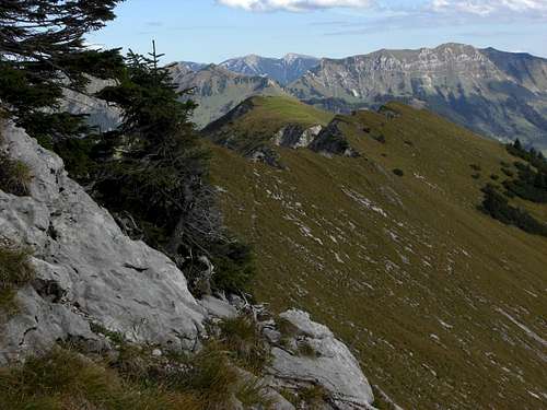
 Torjoch-Stierjoch ridge (Luderwände) as seen from Lerchkogel trail
Nearly every area has its “forgotten corners”. The foothills of Karwendel, the so called Vorkarwendel (Pre Karwendel) is such a forgotten corner.
There are some well-known and often visited summits like Schafreiter, Juifen, Demeljoch. But summits like Torjoch, Stierjoch, Kotzen, are widely unknown. A hike in this part of Karwendel tends to be a lonely one.
The Lerchkogel – Torjoch – Stierjoch ridge, sometimes also called "Luderwände" or Ludernwände" is an east-west – running ridge in the very heart of Vorkarwendel. Torjoch and Stierjoch are the eastern and western limit points of the highest part of this ridge with nearly no altitude difference between each other. They are not very prominent summits within this ridge and normally are climbed together during a full ridge traverse. This is why I describe them together.
 Stierjoch and Torjoch as seen from Schafreiter
The ridges south, east and north limitation is Bächental and Dürrachklamm (Klamm means gorge, canyon), the valleys of the Dürrach river. To the west there is Krottenbachtal and Delpsjoch, separating Stierjoch from adjacent Schafreiter. The huge meadow summit plateau of Kotzen is situated north of Stierjoch whereas Lerchkogel meadows and summit is located east of Torjoch.
In every map I know, Torjoch is named Östliches Torjoch. Interestingly enough there is no Westliches Torjoch on these maps. “Östliches Torjoch” is – indeed – the easternmost point of the high ridge parts. Some 300 meters west of “Östliches Torjoch” is another culmination point of the ridge, maybe you can name this “Westliches Torjoch”….
The ridge traverse is a beautiful hike. There are steep meadows and some easy rocks, a narrow trail marked with withered red-white-red markings, an excellent view of Sylvenstein lake and the Karwendel ranges. Some other features are highland swamps around Lerchkogel Alm huts, the Dürrach canyon which is deep and impressive and, in October, constantly belling stags.
But the best thing is: you nearly will be alone up there. Even on a sunny and warm October day with millions of hikers in the Bavarian Alps, causing endless traffic jams on the roads and highways in the afternoon, we met only five people the whole day (about 8 hours to go for the round trip) and this means “many, many people”!
Getting There
 Stierjoch as seen from Lerchkogel trail
Trailhead for Stierjoch and Torjoch is the little village of Fall at the border of Sylvenstein lake.
Sylvenstein lake is a dam lake and Fall was built up new on the lake shores as old Fall villages was on the bottom of the former valley. With low water you still can see the ruins of old Fall village.
You reach Fall
Leave road number 307 at the signpost “Fall”, cross the village on Dürrachstraße in southern direction until you arrive at the hiker and overnight parking areas at the beginning of Dürrach valley forest road.
Routes Overview
 Torjoch - Stierjoch routes overview
All Fall routes follow the forest road into Bächental. The paved road crosses the river Dürrach after about 1 km and ascends alongside the Dürrach canyon (there are some good lookouts) in the direction of Aquila inn.
Kotzen trail to Stierjoch:
After 2 kms a forest road branches off to the right. Follow this road for about 150 m and take the right hand trail, descending to a huge footbridge across the impressive Dürrach canyon. Ascend on that trail to Kotzenalm Niederleger (ruins). Follow the trail, ascending the northeast slopes and then the east slopes of Kotzen until you reach Kotzen south ridge. Follow the south ridge on some narrow foot trails until you reach the col between Kotzen and Stierjoch. Ascend Stierjoch north ridge on a narrow and steep trail.
Kotzen summit can be easily included in your hike by following the Kotzen south ridge, starting from the above mentioned col.
Lerchkogel trail to Torjoch:
Follow the paved Bächental road 3 kms from Fall to a forest road junction. Take the right hand forest road which descends shortly to a bridge across Dürrach and ascends again after that bridge. After the third switchback with another forest road junction there are three possibilities to go on:
 Highland swamps and Benediktenwand (Lerchkogel trail) Highland swamps and Benediktenwand (Lerchkogel trail) |  Lerchkogel trail Lerchkogel trail |  Östliches Torjoch, east ridge route Östliches Torjoch, east ridge route |
- Follow the left hand forest road up to Lerchkogel Niederleger,
- Follow the trail branching off to your right shortly after the switchback to Lerchkogel Niederleger (signpost, the trail crosses some interesting highland swamps – muddy shoes included),
- From Lerchkogel Niederleger take the marked route to Lerchkogel Hochleger (with the possibility to summit Lerchkogel) and to the col east of Torjoch. Leave the trail here and follow the foot track on the Torjoch east ridge up to Östliches Torjoch – some withered marks will guide you.
- Follow the right hand forest road up to the meadows of Ludernalm with a trail junction. Take the right hand trail up to the col between Kotzen and Stierjoch and the narrow trail which ascends the Stierjoch north ridge.
Alternatively go left and ascend to the col east of Torjoch and continue on the narrow trail of the Torjoch east ridge.
 Lerchkogel as seen from Östliches Torjoch Lerchkogel as seen from Östliches Torjoch |  Connecting ridge, Schafreiter Connecting ridge, Schafreiter |  Upper Bächental and eastern Pre-Karwendel Upper Bächental and eastern Pre-Karwendel |
MTB route:
From Fall bike up the Bächental road until you pass by a little dam. After that dam take the right hand forest road, cross the Dürrach and take the right hand forest road at the first road junction. This one leads you up to another junction.
The right hand road goes up to Nonnenalm; at the end of that road starts a foot trail up to the col east of Torjoch and the Torjoch east ridge trail.
The left hand road ends at a feeding of game animals. Leave the bike and follow the trail up to Delpsalm, Deplsjoch col and the southwest ridge to Stierjoch.
Route from Tölzer Hütte:
Tölzer Hütte , an alpine club hut on the south side of Schafreither, is the nearest mountain hut.
Take the trail in eastern direction to Delpssee and Delpsjoch col and ascend the southwest ridge of Stierjoch. Alternatively take the trail, starting at Delpsjoch and traversing the south slopes of Stierjoch – Torjoch until you reach the col east of Torjoch. Ascend Östliches Torjoch via its east ridge.
 Montscheinspitze as seen from Stierjoch Montscheinspitze as seen from Stierjoch |  Connecting ridge from Stierjoch Connecting ridge from Stierjoch |  Bettlerkarspitze, Schaufelspitze, Sonnjoch as seen from Stierjoch Bettlerkarspitze, Schaufelspitze, Sonnjoch as seen from Stierjoch |
Connecting ridge route:
The east – west running ridge between Stierjoch and Östliches Torjoch is an easy walk with some rock scramble and – to my opinion – pure fun as you stroll across meadows and along a sometimes sharp ridge crest with marvellous views in different directions. The connecting ridge is about 1,5 km long.
Red Tape & Accomodation
 Connecting ridge from Stierjoch
Red Tape
The Austrian part of Stierjoch and Torjoch – the ridge crest is the border Germany / Austria – is part of Alpenpark Karwendel , an important National Park of Tirol.
The Bavarian part of the mountain belongs to the nature protection area „Karwendel und Karwendelvorgebirge”, which covers nearly the whole German Karwendel area.
The entrance is free.
Please respect the following rules in the National Park:

On the Bavarian side around Lerchkogel Hochleger are two animal winter protection areas. Please don´t cross them with skies or snow shoes.
The first one is located at the north slope of Lerchkogel between the forest road to Lerchkogel Hochleger (which can be used with skies and snow shoes) and the summit area of Lerchkogel.
The second one is located at the north slope of a secondary summit between Lerchkogel and Östliches Torjoch.
Accommodation
You find hotels, bed & breakfast and other accommodation at
Fall
Lenggries
A part of the Fall parking areas is reserved for motorhomes overnight stay .
The nearest mountain huts are
Tölzer Hütte
Alpengasthaus Aquila
Gear & Mountain Condition
 Connecting ridge from Stierjoch
Torjoch and Stierjoch are late spring, summer and autumn hikes. The hikes are easy but not too short and the trails are sparsely marked and in some parts badly maintained.
You need good hiking boots and a knack for orientation.
The MTB route should be an easy one, its starts at 770 m and ends at about 1120 m height.
There is no ski route to Torjoch or Stierjoch. As adjacent Lerchkogel is a ski tour and snow shoe mountain I am convinced that Torjoch and Stierjoch are a snow shoe and maybe ski tour aim, too.
User kogo has attached some pictures of a snow shoe tour to Stierjoch and Kotzen.
Check the Tirol avalanche bulletin or the Bavarian avalanche bulletin for that.
Current Weather:
Maps & Guide Book
MapsAlpenvereinskarte 1 : 25.000, map number BY 12: Karwendelgebirge Nord, Schafreiter, Landesamt für Vermessung und Geoinformation Bayern, 2010
Bayerische Topographische Karte, 1 : 50.000, map number UK50-51, Karwendel, Landesamt für Vermessung und Geoinformation Bayern, 2008, with UTM-grid for GPS
Guide Book
Alpenvereinsführer, Karwendel alpin, Bergverlag Rother, München, 2011