
-
 67666 Hits
-
 74.92% Score
-
 5 Votes
|
|
Trailhead |
|---|---|
|
|
Los Angeles |
|
|
Spring, Summer, Fall, Winter |
|
|
5110 ft / 1558 m |
Overview
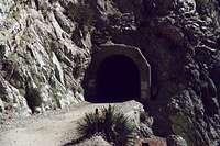
Eaton Saddle is a much-used trailhead in the front range of the San Gabriel Mountains. Just past the big white gate, you start hiking west along the dirt Mt. Lowe Fire Road, crossing under the massive south face of San Gabriel Peak (6,161 ft.) and reaching Markham Saddle in about ½ mile. From here, you can pick up a trail on the right to get to Mt. Disappointment (5,960 ft) and San Gabriel Peak, or take a trail on the left to climb Mt. Markham (5,742 ft.) and Mt. Lowe (5,603 ft.).The photos below are of, respectively, the trailhead gate; the Mueller Tunnel which bores through the south face of San Gabriel Peak; and a view down a deep canyon in the direction of Eaton Canyon. These views are all along the Mt. Lowe Fire Road before reaching Markham Saddle.


If you continue on the Mt. Lowe Fire Road past Markham Saddle, you will encounter a trail going east that takes you to a major trail junction, Tom Sloan Saddle. From Sloan Saddle, you can elect (1) to drop onto a trail taking you northwest into beautiful Bear Canyon; (2) take the east ridge of Brown Mountain (adjacent to the saddle) to its summit; or (3) take yet another trail dropping south into the Arroyo Seco Creek and to the remnants of an abandoned gold mine in Millard Canyon, Dawn Mine. There are other trail options past Markham Saddle including some that will take you south toward Eaton Canyon.
The Mt. Lowe Fire Road itself winds for miles first southerly and then westerly ending at the Sunset Ridge Trailhead above Altadena.
One final alternative from Eaton Saddle is to cross Mt. Wilson Road going away from the Mt. Lowe Fire Road and take a trail that drops northeasterly to Valley Forge, at which point you will find yet another network of trails.
Driving Directions
From the 210 Freeway, exit at Angeles Crest Hwy (SR 2) and go north. At 9.5 miles, you will come to the Clear Creek Ranger Station and the junction with Angeles Forest Highway. Continue straight on SR 2 about 4.5 miles to the junction with the Mount Wilson Road at the Red Box Ranger Station. Turn right. Drive 2.3 miles to the trailhead (there is parking here on both sides of the road).Red Tape
You will need an Adventure Pass to park your vehicle anywhere within the Angeles National Forest, including this trailhead. These passes are not sold at most trailheads. However, they are currently sold at the Red Box Ranger Station (on the way to this trailhead) ($5 per day or $30 for a yearly pass). Otherwise, they are sold at sporting good stores.No permits are required for hiking.