Bluebell Knoll - Day 3 in Utah
When we got off of the 4WD road coming down from the highpoint of Fishlake Hightop and hit the graded dirt road, it felt like we hit a super highway. Our next objective, wasn't all that far away but I wasn't sure we would be able to get up the road onto the Aquarius Plateau where Bluebell Knoll was located. When we got back to the junction of Utah highways 24 -25, it was only 19 miles to Loa on Utah 24, a place where we would gas up and hopefully get up to date information about the road in question. I had called the ranger station in Loa a few days before and the lady that answered the phone told me that she didn't think the road was open yet, that snow still blocked it.
Well, if that were the case, we'd have to skip doing Bluebell Knoll and head for Mt. Ellen, my alternative plan but yet I still harbored hope the information obtained from the ranger station was wrong. When we got to Loa, a small town with a couple gas stations, I stopped at both of them and asked if they knew anything about the road. In all, I asked 5 different people and they all said it wasn't open yet. Dang. I huddled with
Dennis and Andrew and we shifted to the alternate plan of heading directly for Mt. Ellen. After gassing up, we headed down 24 towards Torrey but just before passing through the little town of Bicknell, I got this strange feeling that the road was open. I pulled over and waved Dennis to a stop. I explained my feeling to him and he said "lets try it".
The map at the right shows the route
![Bluebell Knoll area map]() Route map from Bicknell Utah
Route map from Bicknell Utah
A couple miles south of Bicknell, we turned right and followed the directions we had that would lead up to the top of the plateau. Much to our amazement, we encountered no snow banks and the road was clear all the way to our objective with a mud patch or two that we had to dodge. It was a good thing I had followed my intuition on this one as it saved us from coming back a longs ways on some distant date in the future. It was nice to pull right up to the sign as it meant we had just a short hike to get up to the highpoint.
A short hike later we were at the top checking out the views and the register. Well, it took maybe ten or twelve minutes to hike up there as we
![The summit cairn of Bluebell knoll]() Andrew and Dennis enjoying the summit.
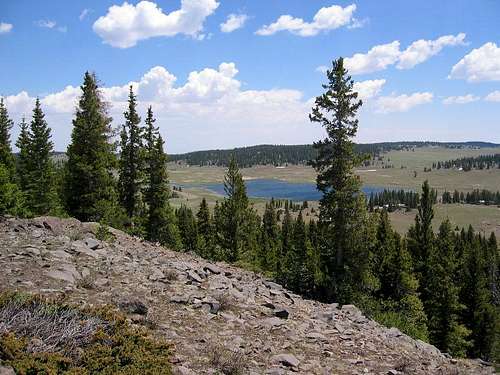
Andrew and Dennis enjoying the summit. were glad to get out of our vehicles and were excited to have found the road a non problem. The top of Bluebell Knoll is actually like the tip of an iceberg as Bluebell Knoll is actually sitting atop a huge mountain called Boulder Mtn. There are trees up there and some big boulders but the highest spot is on the eastern side of the Knoll with a gorgeous view down to pretty Raft lake.
![Raft Lake]() Raft Lake to the Northeast of Bluebell Knoll
Raft Lake to the Northeast of Bluebell Knoll
We signed the register after noting many familiar names and had a snack before we got ready to depart and make the long drive towards our next objective, Mt. Ellen. We drove back down the same road we came up until we connected with the Posey Lake road (good quality dirt/gravel) and made our way past
Posey Lake, over
Hell's Backbone to
Boulder where we had lunch at the
Hell's Backbone Grill. From Boulder, we headed over the scenic Burr Trail and found our way into Capitol Reef National Park. From there we made our way up through Capitol Reef until we could head east into the Henry Mountains to the McMillan Spring Campground where we spent the night but what a day we had just had. Lots of miles covered, fantastic scenery, and good companionship as we traveled the backroads of central/south central Utah.
I'll include more information on this leg of the trip when I put together Day 4 of the Utah trip. Day 4 will be another great day as we chase after Mt. Ellen, the highest point in the Henry Mountains.
![Looking northeast towards the Henry s]() After leaving the Burr Trail, we were headed through Capitol Reef National Park to reach our next objective, Mt. Ellen.
After leaving the Burr Trail, we were headed through Capitol Reef National Park to reach our next objective, Mt. Ellen.The rest of the week summary.
The first part of the day was getting Fishlake Hightop and then surviving the drive back down the nasty 4WD road and making our way to Bluebell Knoll. Day 4 would be spent doing Mt. Ellen and getting our selves to La Sal Pass where we'd spend the night for day 5 and Mt. Peale. However, That is getting too far ahead and here is the way the week in Utah went with some of the days already treated to a trip report.
In the month of
July, this is what I was able to do and see:
Day 1 - Naomi Peak of Cache County and the aborted Rich County effort.
Day 2 - Mine Camp Peak & camped out at 11K feet 2 miles from Fishlake Hightop.
Day 3 - Fishlake Hightop and Blue Bell Knoll. Drove to within 5 miles of
Mt. Ellen and camped. Went via Boulder & Burr Trail to Capitol
Reef Nat'l Park and then east into the Henry Mtn Range
Day 4 - Mt. Ellen and then drove via Hite, Natural Bridges Nat'l Monument
and up to a spot where we camped close to Mt. Peale
Day 5 - Mt. Peale. Then some time in Moab and drove to a spot where we
were close to Mt. Waas
Day 6 - Mt. Waas. Then spent time in Arches Nat'l Park before we drove to
a spot where we camped close to East Mtn.
Day 7 - East Mtn and a long drive to So. Tent Peak. Then drove to a spot a
few miles from Monument Peak.
Day 8 - Monument Peak and then drove up and did Eccentric Peak in the
eastern Uintas. From there I started my drive home. Left Eccentric TH at 5pm and drove into Kennewick the next morning around noon.
I hope to put up a trip report for each day. In the 8 days, I did 11 peaks, saw two National Parks and a national monument, drove the Burr trail and went over Hell's Backbone into Boulder. Car camped every night and loved every minute of the trip.
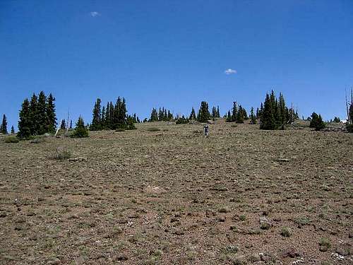
![Strolling up the Knoll]() Andrew making the hike up Bluebell Knoll
Andrew making the hike up Bluebell Knoll
Comments
No comments posted yet.