The Trip
After years of living in Seattle hearing my companion climbers and hikers speaking enthusiastically about the Enchantments, the prospect of picking up a prime-time (mid July) permit from a fellow club member was too good to pass up. So I told my boss I needed an emergency week off, and got a couple of friends to join me for four days in the core of the Alpine Lakes Wilderness.
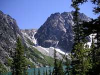
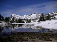
![Dragontail Peak and Aasgard Pass from Colchuck Lake]() Aasgard Pass and the north face of Dragontail Peak
Aasgard Pass and the north face of Dragontail Peak![Cashmere Mountain from Colchuck Lake]() The view in the morning from our first camp, at the south end of Colchuck Lake.
The view in the morning from our first camp, at the south end of Colchuck Lake.
We picked up our permits at the Forest Service, and were shocked to find there was no one there for the 5 lottery spots available every day, even though it was a Monday. We made an emergency purchase in town to fill in for a foregotten ice axe, and headed up Icicle Creek Road. We worked the car logistics by leaving Dan's car at the Snow Creek Trailhead, then drove up to the Lake Stuart Trailhead.
Dan evidently ate some bad Leavenworth brats the night before, and his tummy was bothering him on the hike up Mountaineers Creek from the Stuart Lake Trailhead.
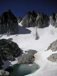
![East Dragontail Peak (r) and Witches Tower (l) rise above Mist Pond at Aasgard Pass]() At Aasgard Pass we got our first glimpse of the the wonders of The Enchantments
At Aasgard Pass we got our first glimpse of the the wonders of The Enchantments Not particularly eager to tackle the oft-warned-about Aasgard Pass in this condition and with our late start, we elected to spend the first night at Colchuck Lake. This eased the task of toting packs over Aasgard Pass ("Colchuck Pass" on the USGS topo) because we were fully rested, Dan shook his tummy problem, and we were doing the task in the cool early morning.
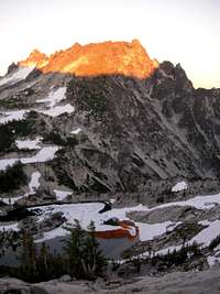
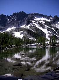
![McClellan Peak from our camp above Crystal Lake]() The view in the evening from our second camp above Crystal Lake
The view in the evening from our second camp above Crystal Lake
There was only a single small snow patch left on the hike up to Aasgard (Colchuck) Pass. Trails and lakes through the upper basin were still about half snow-covered. There was snow on the trail throughout the upper basin and down as far as Inspiration (Talisman) Lake, elev 7190. It seems as though about half the landmarks in The Enchantments have two names!
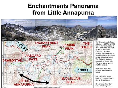
We camped at 7500 ft on the cliff edge at the base of
Little Annapurna and above Crystal Lake. This is a nice isolated site 300 yds south of the trail and toilet at the east entrance to the upper basin above Inspiration (Talisman) Lake. Great views of all the peaks here; I guess that goes without saying about any spot in the upper basin! Of course the scramble up Little A beckoned, for some views south across the Ingalls drainage to Rainier, Goat Rocks, Adams, and of course the entire Enchantments Basin, Lakes, and Peaks. That evening we sat in silence admiring the alpenglow on McClellan Peak above us and its reflection in Crystal Lake below.
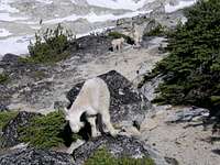
![Goat Neighbors]() Our neighbors for three days.
Our neighbors for three days.
The bugs were not all that bad. In four days the goats changed from exciting to fascinating to charming to interesting to ignored to bothersome to troublesome. By the end of our encampment one group was spending the night on the cliffs next to our camp, waiting for us to get up to urinate on the rocks.
![Little Annapurna from Gnome Tarn]() The not-so classic shot of Little Annapurna from Gnome Tarn. The classic photo (at the top of this page) is of Prusik Peak, taken from the far side of the tarn.
The not-so classic shot of Little Annapurna from Gnome Tarn. The classic photo (at the top of this page) is of Prusik Peak, taken from the far side of the tarn.Please follow the guidelines and avoid peeing on the vegetation, because the goats will trash anything that has urine on it! This can be used to advantage, however. If there is a goat nearby, and you want it in a particular position for a picture (goat next to quiet pond, goat in front of Xxx Peak, goat on rock next to camp, goat silhouetted against evening sky), just go to the spot where you want it to pose, pee on the rock, step back and snap your photo.
We hiked to Prusik Pass Wednesday morning to check out the view north into the Lost World Plateau: Cannon Mountain, Shield and Earle Lakes, and the Rat Creek group. We came back via Gnome Tarn (still half snow-covered) for the classic picture of Prusik Peak. Traversing south from the Pass to the Tarn involves a little scrambling, but makes for a nice little loop above Perfection (Rune) Lake. This morning hike was a warm-up for
Dragontail Peak in the afternoon -- a strategy that allowed Snow Creek Glacier to soften enough to kick nice firm steps up the 40-45 degree slope to the col and the easy walk to the airy summit.
![Little Annapurna from Perfection (Rune) Lake]() Classic Enchantments Photo #2 - Little Annapurna from Perfection (Rune) Lake
Classic Enchantments Photo #2 - Little Annapurna from Perfection (Rune) Lake![McClellan Peak from Leprechaun Lake]() View of McClellan Peak on our way out.
View of McClellan Peak on our way out.
Thursday we took our time through the lower lakes (Leprechaun and Vivian), and then hoofed out the last eight miles as we debated which way is best into the Enchantments; Aasgard? Snow Lake? or perhaps the trails less traveled -- Ingalls/Annapurna? Rat Creek? Tokatie/Prusik? The definitive answer: any way.
![Goat at Dawn]() The magic of The Enchantments will draw me back soon!
The magic of The Enchantments will draw me back soon!Itinerary
Monday:
From Stuart Lake Trailhead (3300 ft)5 miles to south end of Colchuck Lake (5570 ft)
Tuesday:
Over Aasgard Pass (7800 ft) to camp at 7200 ft base of Little Annapurna. Afternoon hike up
Little Annapurna to summit (8440 ft).
Wednesday:
Morning hike down to Perfection Lake (7190 ft) and up to Prusik Pass (7400 ft) and Gnome Tarn. Afternoon climb of
Dragontail Peak (8840 ft) via Snow Creek Glacier and SE ridge.
Thursday:
Hike 1.5 miles through middle and lower Enchantment Basin (Perfection, Sprite, Leprechaun and Viviane Lakes). Leave Basin at Lake Viviane (6785 ft), down 2 miles to lunch at Snow Lake dam (5415 ft) and out last 6.5 miles past Nada Lake and Snow Creek Wall to trailhead (1300 ft).
Enchantments Basin Lakes Guide
Discovery of the Enchantment Lakes Basin is attributed to A. H. Sylvester, a U.S. Geological Survey topographer supervisor of Wenatchee National Forest in the early 1900s. As a result of his position, many names throughout the west are his handiwork, and he is responsible for the names “Enchantments” and the lake names with adjectives and emotions. In the latter half of the 20th Century, Bill and Peggy Stark made annual visits to the Basin, and attached a different set of names to the lakes drawn from mythology.
The official naming rulings of the US Board on Geographic Names in the 1960s resulted in a mixture of the two name sets being adopted as official. The current policy of not adopting new names for geographic features in wilderness areas probably precludes the rest of the names identified by the Starks from ever achieving official status.
Fred Beckey adopted the Stark's names for the major lakes on a map in
Cascade Alpine Guide in a sketch map.
Here is a cross-reference between the various sets of names, listed in sequence by elevation, from highest to lowest (i.e. roughly west to east). Please pardon the formatting -- I'm an HTML neophyte, and don't know how to do tables. Links are to pictures of the lakes -- I have not found one of Naiad (Temple) Lake, so if someone has one or finds one, let me know.
USGS______________Source__Beckey__________GNIS Alternate_______Elevation
Unnamed *_________________Mist Pond____________________________7745
Tranquil Lake_____AHS_____ Lake Freya______Lake Freya___________7838
Unnamed *______________________________________________________7750
Isolation Lake____AHS_____Brynhild Lake___Brynhild Lake________7703
8 Unnamed Lakes *______________________________________________7660- 7540
Gnome Tarn________BPS_____Gnome Tarn______Grone Tarn___________7365
Inspiration Lake__AHS_____Talisman Lake___Talisman Lake________7195
Perfection Lake___AHS_____Rune Lake_______Rune Lake____________7116
Sprite Lake_______BPS_____Sprite Lakelet_______________________7116
Crystal Lake______BPS_____Crystal Lake____Not in GNIS (?)______7000
__________________________Troll Sink___________________________7000
Leprechaun Lake___BPS_____Leprechaun Lake_Contemplation Lake___6875
Lake Viviane______BPS_____Lake Viviane____Solitude Lake________~6780
Temple Lake_______AHS_____Naiad Lake______Naiad Lake___________6875
* Uncertain which name is associate with which lake, but the Starks identified other lakes with following names: Valkyrie, Lorelei, Dryad, Pixie, Brisingamen, , Reginleif, and Titania.
** GNIS lists Perfection Lake elevation as 7556 – clearly an error
The pass at the west end of the Enchantments Basin known universally among hikers and climbers as "Aasgard Pass" is actually officially designated "Colchuck Pass", and appears as such on USGS maps. The US Board on Geographic names ruled in 1967 and again in 1988 against changing the name. The Green Trails maps uses the more commonly recognized "Aasgard Pass".
Vote!
![Rik on Andrews Thumb]() Random spire on the Gilbert Peak West Route - Adams in the background Photo credit: Andrew
Random spire on the Gilbert Peak West Route - Adams in the background Photo credit: Andrew
The neat thing about web resource such as SummitPost.org is they are so easy to edit in response to comments or suggestions. Please
return to the top of the page and provide a page score on the pages you visit. You may also send a quick note to the authors with ideas on how to improve their descriptions!
Thanks -- Keep Climbing Mountains, and Don't Slip!


Comments
Post a Comment