Hiking Green Mountain, Black Canyon of the Gunnison NP, CO
“So, Dad, how’s the heel?”
Curtis was referring to my left heel. A few days earlier
we'd hiked to the top of High Dune in Great Sand Dunes National Park, Colorado, followed by a 1-mile hike (roundtrip) to Zapata Falls. On the return from the falls the rocky path had aggravated a nagging problem I’ve been having for the last few weeks with my left heel: I could barely hobble back to the truck. But, today it was feeling pretty good and I really wanted to make this hike to Exclamation Point (3-miles roundtrip) and, if the heel was okay, to summit
Green Mountain (7-miles roundtrip). “It’s feeling fine, Curtis. Grab the gear and let’s go!”
For the past two days we’d been visiting
Black Canyon of the Gunnison National Park, Colorado. This is an annual rite for us; we’re visiting all of the U.S. national parks (the real ones that congress has awarded national park status, that is). We’d been visiting the Black Canyon south rim, and had camped that evening at East Portal. SP member
Csmcgranahan had recommended a visit to the far less visited north rim, as well as a hike to Exclamation Point and Green Mountain. We figured that was an excellent suggestion, especially since Curtis and I wanted to tackle our first 14er before leaving Colorado … on our last day after acclimating for a week. So, we’d left East Portal at the break of dawn and, 2-1/2 hours later, after a drive around the incredibly beautiful Curecanti National Recreation Area, we were preparing to depart the north rim ranger station at the
North Vista Trailhead.
It was obvious even here that this place is far less visited than south rim: There was only one ranger, no visitor center, no gift shop, and his primary interest as we arrived seemed to be a group that was returning from a hike with their dog. Uh-oh. No dogs allowed on this trail. He told them to await the arrival of an enforcement ranger who was going to ticket them. As we were making our final preparations to depart we overheard that this group had rankled the ranger because he’d told them an hour earlier that they couldn’t take the dog on the trail, and they did it anyway. I supposed I couldn’t fault the ranger, after all. And, true to his word, another ranger arrived on the scene within moments.
Now, I don’t know how it turned out. But, the ranger who arrived was familiar to Curtis and me. Just the day before, while walking out to Marmot Rocks on south rim to do some bouldering, we’d seen this attractive, young female ranger parked at the Painted Wall parking lot. After Curtis bouldered a few routes, we walked back and there were some climbers walking the road ahead of us. She met the climbers and got onto their case for climbing without registering. Another uh-oh. Anyway, about 10-minutes later she was making hand movements and describing routes and having a good time talking to these two young men. And it ended with her cautioning them, “I’m not going to ticket you. But next time register, and tell all your friends to do so, too!” So I figure that the couple with the dog probably got off. The only question in my mind: How in the world did this ranger work both sides of the canyon? It’s a 2+ hour, one-way freakin’ drive on a very mountainous road!
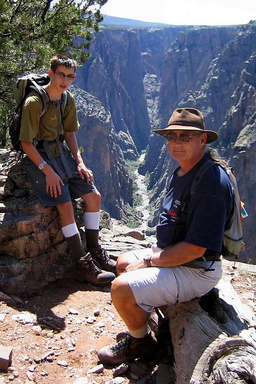
![Black Canyon of the Gunnison from Exclamation Point]() Curtis and Mark at Exclamation Point, Black Canyon of the Gunnison
Curtis and Mark at Exclamation Point, Black Canyon of the GunnisonLoaded up and ready to hike, Curtis and I head down the footpath to Exclamation Point. It’s a typically good NPS trail: Reasonably wide, with few rocks or other obstacles to clear. We pass a few “Viewpoint” signs, so make the side trips to view the canyon. And it is an awesome one indeed! Each stop is above the
Painted Wall, the highest cliff in the state. At 2,000’, it’s a sheer drop to the depths of the Gunnison River in Black Canyon. And the NPS didn’t bother putting up fences to protect the careless.
We shoot a few pictures and continue on to Exclamation Point. We come across the sign pointing the way, and make the appropriate turn. After a short distance the trail splits in two directions, so we veer to the left, away from the cliff on the right. We eventually arrive at it: Incredible! Not only is the sheer drop to the river immediate, but from this vantage point we can see a far distance to the southeast right up the maw of the canyon. This is a definite “Kodak moment”, so I hang the camera from a nearby tree and grab a shot. Which brings up the point that we hadn’t seen anyone else on the trail as of that time. But that doesn't mean we aren't aware of the presence of others. On the opposite side of this very narrow canyon are two very popular stops for the south rim drive: Painted Wall and Chasm View. And we can see the windshield reflections from the parked cars that indicate there are dozens of people over there looking at Curtis and me from behind protective fencing, wondering how we got to the very edge, the sheerest-most top, of the highest cliff in the state of Colorado.
After spending a bit of time admiring this great view, and letting those hoards wonder about us, we continue on down the remainder of the loop to return to the main trail to Green Mountain. “How’s the heel, Dad?” “Let’s head to the top, Curtis; I’m feeling fine!”
We continue our hike. In pretty short order the trail gets steeper. Not too steep. And, it’s still a good trail, though there are now a few places where there are more rocks or other obstacles than before. There are several switchbacks as we ascend Green Mountain. There seems to be a fair amount of shade, but that may be deceptive: Large clouds are building to the south, blocking the sun. Because of the trees along the trail we catch only occasional glimpses of the canyon. They’re frequent enough, that is. Not at all like a couple years back when we were hiking on the AT and we had to search for what seemed like miles for a small opening to take a picture of the surrounding mountains! No, this is plenty frequent. And with each opening in the trees the wonder of Black Canyon becomes more obvious. As we ascend higher, it’s almost like we’re in a helicopter preparing to make a low flight right over the canyon. The view is just incredible! I know, I keep saying that. But that’s because it was!
We hike for another hour, passing another pair of hikers. We reach a somewhat steeper section of very rocky trail. If we’re reading the map correctly this is the last few feet to the very summit of Green Mountain. In fact, a short scramble (perhaps 75-feet) and we reach the top.
![Lichens on Black Canyon of the Gunnison North Rim]() Colorful rock and lichen along the North Vista Trail
Colorful rock and lichen along the North Vista Trail We turn around and the view of the canyon is just like before, but even better. Well, perhaps not quite as good as Exclamation Point, but the best view of the canyon we’ve seen from anywhere else the past two days! We hike around the loop on top of the mountain and enjoy the scenery in all directions. Because of growth towards the north end of the trail, seeing in that direction is somewhat obstructed. But, regardless, the best thing to see from here is Black Canyon of the Gunnison itself. We complete our loop when that other couple arrives at the top. We exchange pleasantries, learning that they had arrived from Minnesota the day before, and that they’re experiencing a lot of trouble dealing with the altitude change. Certainly I can identify with that: Just a few days earlier I wasn’t sure I’d make it to the top of High Dune in Great Sand Dunes National Park because of my own need to acclimate.
We decide to leave the top of the mountain to them, and head back down. The return trip is easy. I send Curtis ahead because I want to stop and take a few pictures. I was especially interested in this very colorful, lichen-covered rock I'd observed during the hike up. I wanted a few minutes to capture a nice image, with the canyon in the background. It’s a challenging lighting situation, but I’m happy with the final result. As I continue down I meet a few other hikers out for the day. I note that the clouds to the south are building and blackening. Good thing we’re inbound! About 2-½ hours after starting out, I return to the ranger station. Curtis beat me down by about 15-minutes, but that wasn’t important. What was important was that my heel hadn’t been a problem, and that I didn’t have the acclimation problems I’d had the prior week on High Dune. Yes: Tomorrow we plan to hike up Mt. Evans!
Comments
No comments posted yet.