(Page best viewed at monitor setting of 1024 by 768.)
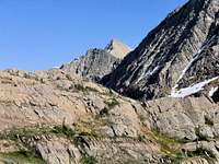
"Classic" view of McDonald Peak.
This much-anticipated climb happened months ago; it was an outing of substantial effort, and success on one of the area’s legendary mountains, yet even after all this time, the summit is still not what it is all about. Perhaps some day it will be, but for now memory serves itself up quite separate from what must have been a magnificent peak—highest point in the Missions (and an ultra-prominence club member), rugged, precipitous walls of rock, a couple thousand feet of steep snow and the accompanying (necessary) ice ax, with a beautiful day on top even at close to 10,000 feet. And though as an experience it falls short of a "Touching the Void" life-and-death drama…it is enough. We did indeed make the summit, and while I’m relatively certain McDonald Peak is the heart and soul of an area giving definition to
Not long on the way.
why such places are entered in the first place, and that the summit is (or rather, I guess I should say…was) appropriately wonderful, the uncertainties of memory and emotion do not make that high jumble of rock to be the excursion’s crowning achievement. Rather, what we did that was really difficult, that mattered more than anything, was make it off the mountain, out of the area, and back to our vehicle. That effort (and one other, involving me, alone) is a stronger vision in my mind than climbing the thing in the first place.
The chronology does not flow naturally as it reaches forward through the months, but appears rather in bursts of vision and emotion as the more powerful images crowd to the front. Those memories are difficult to move,
Early morning bushwhack.
as though refusing placement in a more accurate timeline, and stand before me, insisting that before anything else, they be dealt with. Nevertheless, I'll try to relate the adventure as it unfolded, but it is difficult. I know, for example, that we left camp shortly before 6 AM, and even at that early hour the day gave every indication of being just about climbing perfect; it also comes to me that the decision had been made to circumnavigate about a thousand feet above Ashley Lake [note that Ashley Lake is actually two lakes: Upper Ashley and Lower Ashley—with the upper being the larger—but the two are separated by a narrow-enough strip of land to be normally referred to in the singular, as "Ashley Lake"] in the belief it would not only save elevation loss, but also help avoid a difficult and time-consuming scramble up some cliffs alongside a waterfall which just happened to be an unavoidable obstacle if following Ashley Creek into the upper reaches of where we needed to go.
Above Ashley Lake and the waterfalls
And I know this was accomplished more or less successfully, although cliffs and forest were such that continued traversing eventually became impossible, even though for a way we were able to follow a game trail (a trail which, unbeknown to us at the time, would become quite important the next day) before the terrain forced us down to the creek, but only after having successfully made certain the descent ended at a point above the waterfall. The Missions have comparatively few man-made trails (and McDonald Peak is certainly no exception!), so almost the entirety of that first day—in fact, most of the two-day outing—was spent pursuing wilderness with nothing to guide us but a map, a GPS, and (I'd like to think) common sense. The peak itself cannot be seen for a substantial portion of the climb, and all in all, as vision looks back from this distant perspective the day's ascent was one of steady progress, although somewhat slower going than we wished.
Lunch with a view!
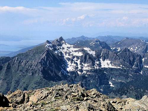
McDonald East Ridge.
First view of the summit.
I know all that as a remembered fact, as something with which to set the stage for the adventure to come; so in truth, the better part of that first day was taken with effort and time to reach the summit, and of course those memories are indeed there, but survive as seen through a thin cloth of pale gossamer compared to the ones from later that afternoon, and the following day. Perhaps the necessity of having to plunge the handles of our ice axes so as to obtain a firm anchor in the event footing on the steepness of snow gave way, this for maybe the last thousand feet or so, should have set off alarm bells in my (relatively) inexperienced steep-snow mind, that…well…after all and never forget, the descent is still part of any climb. But Bob and Duane were ahead, pulling steadily toward the summit; it was a bit tiring, but I too kept at it, and eventually—eleven hours after we began—the three of us were on top the Missions.
Glacier Pk & Unnamed 9328.
Wonderfully rugged country!
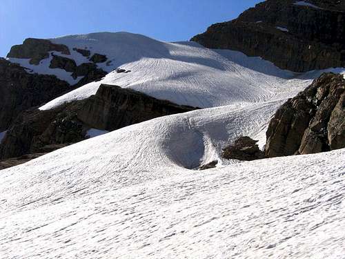
Glacer and East Glacier Peaks.
Working our way up, summit in sight, Bob and Duane small in a big country...
At this point it should probably be noted that McDonald Peak is often not done in a single day, but usually with a planned camp somewhere on the mountain; it is just too big and wild, with too little in the way of terrain amenable to rapid progress. However, sometimes the plan (ours, in this instance) is for only one…very long…day. But even though we were ready for as many of those long hours as the mountain saw fit to throw at us, an eleven hour ascent had not been part of the equation. On the summit. Five PM. A really rewarding, fine summit—but not much time to lounge about. Then it was time to leave that high place, and make—although I did not know it at the time—the kind of memories pushing forcibly to the front, and lasting a lifetime.
So…we started down, and there is nothing whatsoever pale and gossamer about what happened next, and it is all on me. This is not the stuff of shared experiences, of comrades struggling against odds and difficulties merely to return home. I'm out on a limb here, and wrestle with this memory alone. It has to do with glissading off a peak, with me not being in the least adept at such an activity (by that I mean I'd never done it before). I looked down at our immediate future, with the snowfield being entirely too steep (much steeper than during the ascent!) and running off into just about forever, and I'm pretty sure never really ending. At least it doesn't now—end, that is—not in my mind; not while looking down from McDonald Peak.
Looking over Sheepshead into the Mission Valley.
Bob and Duane have about a bazillion times more experience on snow and ice than I do, and so to them this glissading off the summit was a thing swiftly accomplished, maybe even an enjoyable way to begin a long trek off and out. I mean, the many times I've used my legs to ski down snow (and scree) has always been a pleasant rush, so it is easy to see how the appeal of glissading would be much the same. But like I've already said, I had never done it before, and the slope now before me was both long and steep. I was given good instruction on what to do, did a couple short practice runs, then the descent began in earnest.
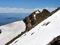
The slope causing my adrenaline rush!
Probably not surprising, but to the uninitiated glissading is not as easy as it looks, and I made it quite a bit more difficult than needs be. Bob explained how to simultaneously use both feet and axe as a drag, thus alleviating not only undue strain on arms and shoulders, but also the (really) disconcerting tendency to rotate, with the resulting possible head first descent down the mountain! Anyway, for a while it was okay, and difficulties encountered were an acceptable part of learning a new technique; after a relatively short distance, if my arms and shoulders became too tired, or if I felt on the verge of too much speed, I'd just stop and rest, then proceed on. A couple times I lost control, ending those brief moments with relatively easy self arrests, but the combination of struggling with something new, at the same time seeing the never-ending slope as a beckoning, unavoidable maw falling away before me, was not an easy thing with which to deal. Eventually it became necessary to give myself a mental break, and so worked my way over to an intruding scree field, willing to put up with its loose and unsure footing even though it would considerably slow the descent.
Mount Calowahcan, Flathead Lake, and points north.
My partners had gone on ahead, and could be seen waiting further down the snowfield on some protruding rocks, at the point where our direction off the peak would change as we began to gradually wrap back around the mountain, the descent become not so steep, and the slope could be simply walked. But first I had to get there. Coming to the end of the scree there was nothing for it but to continue the glissade. However, in order to reach Bob and Duane it would be necessary to work across the slope at an angle, and what was even more disconcerting, the angle of descent had increased. I don't know how else to put it other than to say that at that point I was quite uneasy about the situation, but that it was also perfectly obvious there was nothing for it but to go.
Snow, rocks, light, grace...
At first everything was okay, even though it meant working against the natural grain and flow of the snow, but one thing not seen, of which I was not aware, was that due to the early summer heating and cooling cycles at that elevation, a crust of ice had formed in areas on the snowfield, with the condition being worse towards the center. Prior to working down the scree, I had been staying relatively close to the snow's edge, and so as of yet had not encountered any serious icing, but in crossing to where I needed to go, would unknowingly encounter the worst of it. Probably at this point everything about to unfold was only too predictable, and it simply remains to be said ...and then it happened. The surface ice was strong enough it forced my axe handle up and out of the snow, and without that anchor I was suddenly careening down a steep slope with at least a thousand feet (or more!) of nothing to stop me. This was not to be one of those nonchalant self arrests mentioned above. In the deepest, darkest sense of the word, this was a serious situation!
Kakashe Mountain, and all the way to the Bitterroots!
At such times conscious thought isn't part of the process, it is all about reaction. Which is what happened to me. It was an instinctive move to flip over and slam the axe home, but the slope was enough, and speed, that it took like what seemed forever to begin slowing. After the head was embedded in the snow I remember yelling over and over in my mind, "don't let go, don’t let go, don’t let go!" and also—and this may well have been an error—that there was just enough icy crust that if I dug my boot toes in, it could well flip me, and then the situation would be made even worse. So I kept a death grip on the axe head, kept my feet in the air, and eventually, at long last, came to rest. At that particular moment, non-motion was an unbelievably wonderful sensation, and would that it could go on forever!
One thing gained by this uncontrolled careening down a mountain (aside, that is, from the understanding that an ice axe is a greater invention, even, than the wheel), is that as I picked myself up and began to nonchalantly (uh-huh) brush the snow and ice off, and see what might be broken, is that that mad rush of a descent had taken me quite a bit closer to where I needed to be. I don't remember much of the rest of the way to the safety and mental haven of Bob's and Duane's rock, but it mustn't have
Take a break. Relax.
been much of a problem, or I would no doubt have made a mess of it. And speaking with Bob, he said that in all likelihood (and I'm sure he is right) it would have been okay had I planted my toes in the snow, that the real problems with flipping yourself are usually associated with crampons grabbing hard ice. Lesson learned. Plus, it is a good feeling to know my annual early spring self-arrest practices in GNP have been worth it, and when it is really, really important to stop myself I can do so. But oh-my-goodness what an unbelievable adrenaline rush!
That was my traumatic moment, and had nothing else occurred, it would have merely been something to remember as an exciting event, not affecting the rest of the excursion in the least, and we would have either hiked out quite late that night, or bivouacked somewhere lower down in the shelter of trees, and gone out the next morning. Unfortunately, that was not to be all, and what happened next would not be long in the unfolding.
South from the summit into a wild, jumbled, mess of mountains!
Continuing to descend after resting a short while on the rock, our progress was comparatively rapid. We left the southeast slope of the mountain to head more directly south via somewhat more moderate terrain as this route took us into a different drainage, (mercifully!) away from the one I’d so recently done my best to slide through. It was a nice late afternoon, and the day had become just a matter of putting in the necessary hours on the trek out. One thing to know about this area is that it is wonderfully, spectacularly, wildly beautiful, and so as we (or at least I—I don't think the conditions giving me so much grief were nearly the same level of difficulty to my more adept friends) happily descended this slightly lesser slope, I was content to lag behind while taking pictures.
It seems serious things often happen without warning, a gentle slipping into our lives, and so it was this time. Marveling at the country through which we were moving, happy at having made the summit, pleased at still being alive so I could tell my friends about having made the summit, my reverie was interrupted by—I don't know what; possibly I heard the sound of slipping, or sensed a jerking motion out of the corner of my eye, or I suppose he could have cried out, but something caused me to glance ahead, and see Bob lying on the snow. We have all slipped many times in the mountains, usually to the accompaniment of "are you okay?" from comrades, or if alone (or maybe even if not alone) perhaps a wailed curse defines the moment, or a bemused take on our individual clumsiness, but the point is that aside from pride issues (and isn't it great how the mountains take that from us?), in all our mishaps we are almost never really injured. But not always. And there was something about how Bob was lying that triggered a response in my mind that this was more than, "It’s only that his foot slipped out from under him, he'll hop up, and we'll continue on our way." By the time I reached the two of them, it was only too apparent that something was wrong.
At least our unplanned bivy site came with a view!
The slip, and subsequent fall, had resulted in a torn, or badly strained, quadriceps thigh muscle, and the situation was that not only was he in quite a bit of pain, but could just barely walk. The first thing to do was determine the extent of mobility, so we slowly continued on our way in the hopes that—just maybe—the injury could be "walked off." It didn’t take long to realize that, even with the use of trekking poles, this wasn’t going to happen, so when we came to a kind of "island" in the snow—relatively level, with grass, and even a couple large boulders for shelter—we stopped to assess the totality of our plight.
Obviously, we were going nowhere that late afternoon and evening. It was now 7 PM with still around 3 hours of daylight left, and we had numerous possibilities to consider. In certain regards the situation could have been worse; it had been an unusually warm day, and even though we were still around 7,000 feet elevation, we all had extra clothing, so while the night would no doubt become chilly, the feeling was that we had enough wraps to ward off serious exposure. Two of us also had emergency blankets, we had matches for fire—and having dropped back below timberline, would have available fuel. We also had filters for water, but unfortunately not all that much left in the way of food—a couple bagels, cream cheese, nuts, two or three power bars of one type or another—and, maybe most important at the moment, pain pills for Bob, who did not look to be in any condition enabling him to make his way out the next day. Or at least that appeared a disconcertingly real possibility.
We also had two cell phones, and in a way, as I look back on it, the conversation was almost surreal. "Maybe we should climb to a high point on one of these ridges, and call S&R for help...Unless it’s a life-threatening injury will they come?...Well (this from Bob), it’s life-threatening if I can’t walk!...Can they land a helicopter here? Maybe they’d fly us out...Will they fly all three of us out, or just Bob?...If they do get a helicopter in here, is it free? Bob, how much are you willing to spend?...Hey, I just thought of something; who do we call?—we’re in the Tribal Wilderness; do we call the Salish/Kootenai Tribes, or do we call Lake County?" Well, the decision was made to call for help, so Duane and I hiked to the nearest high point, planning on just calling 911, and letting them connect us to the appropriate rescue folks. All of which turned out to be a moot point—the cell phones wouldn’t connect! So we headed back, collecting firewood along the way for our unplanned bivouac.
Bushwhacking country!
Getting the fire going provided some lifting to our spirits, more discussion ensued, we pooled our food into a meager dinner—leaving some for whatever might transpire the next day—resolutely prepared for the next few hours to the best of our capabilities...and night came to the Missions. A very, very long night. The warm air cooled rapidly after sunset, cooled as it settled on the snow above and around us, began to flow downhill, and soon thereafter we found ourselves huddled against a cold, constant, not insignificant wind. Around midnight it became cold enough there was no option but to preserve what little heat we had in our huddled state, so rather than move, let the fire go out. Not a big loss, because by that time the combination of wind and temperature had rendered the fire pretty much ineffective. Believe me when I say that night was a sleepless, never-ending torment!
Eventually, of course, dawn came; slowly, uncertainly, but it did come, and with that first blessed paling, we prepared for the day. The plan was, as best as possible—if, indeed, it was possible—to hike out. It made sense to at least try. At our present location it was not possible to call for help, but maybe Bob could, at the least, hike to a point the cell phones would connect, at which time, being in a (hopefully) more geographically favorable location, we would be somewhat better able to make the necessary decisions concerning help, extraction, or even continuing on our own. However, paramount at the moment was the overriding, not to be avoided, question: could Bob walk? We ate what little had been set aside for breakfast, pumped our injured comrade as full of pain killers as was felt to be safe, divided the weight of his pack between Duane and I, and the three of us embarked on—no matter how it was to unfold—what could not fail to be anything but a memorable day.
A country of cliffs and forests under morning overcast...
We had not gone even a hundred yards when there was a clap of thunder, and (of all things, at 6 in the morning!) it began to hail. Not violently, but enough to force us under a sheltering tree where for a few minutes there was nothing to do but think about the vagaries of fate, and consider whether or not this might be a harbinger of something upon which it was best not to dwell. Fortunately, the storm was both brief and, aside from the minor annoyance of wet surroundings, not all that big an event, and the morning quickly reverted to the non-problematical weather pattern of the prior day.
Stepping out from under the branches of our friendly tree, it was time for the business at hand. After carefully studying the map in combination with knowledge gleaned from the previous day’s ascent, the decision had been made to not retrace our route, but to head, in a manner of speaking, "cross country," so as to avoid further descent of the snowfield, as well as the large boulders along Ashley Creek. It didn’t take long to realize that Bob, even though obviously far from healthy, was doing better than expected, and we were able to make slow, but steady, progress. The problem, naturally enough, was that the country was not level, was, in fact, quite rugged, and the day quickly became a matter of scouting ahead to find a route passable for a person with a quite painful leg, then retreating from what could not be done. Sometimes we would climb a bit, then have to back down; other times it was a matter of descent only to realize that way was too precipitous, and so we’d gather, discuss, and try something else. Progress was slow, uncertain, and tiring, but progress there was.
Something that had been weighing heavily on my mind was our inability to call out, and that I had no way of informing work of my status. This was actually quite important, as I was to work the late afternoon/early evening shift, and as a manager, would be the only one there with keys to lock the store. Plus, I had told them our destination, and a no-show on my part
Painful walking...
would have (hopefully) prompted a concerned call to S&R that someone "was missing in this huge area around McDonald Peak, and no we don’t know exactly where you should look," with the resultant confusion and uncertainty on the S&R end of things. (Or it could also have prompted a party by my work cohorts, but that is another story.) So we tried calling approximately once every hour, each time from a relatively high point, and it wasn’t until the fourth try, at around 10 AM, that we were able to get through, and this was accomplished only because Duane held the phone absolutely still while I spoke, so as to maintain a connection which can only be described as "just barely," but fortunately it was enough; the necessary information was relayed, and this brief respite and positive development out of the day’s intensity lifted all our moods a bit. It certainly did mine!
Often the forest was too dense, or there were cliffs which would have been a barrier even with three pairs of healthy legs, or the only progress was that of slipping and sliding down those beautiful, green, nightmarish slopes of grass, or managing a creeping traverse across the same, and then the day began to heat at around the same time we entered the south-facing slopes which, hopefully, would eventually bring us to a point from which a descent to Ashley Lake would be possible, to the one and only trail out of this wild and rugged McDonald Peak country, and back to our vehicle. The goal, then, was Ashley Lake; if that could but be accomplished, well, after struggling through what it took to make it that far, it would be a comparatively easy jaunt back to where it had all begun only the previous morning.
Slowly, we moved around the mountain, and then heat began to be a factor as the day warmed. At one point we descended almost to Ashley Creek, only to realize the way was impassable. So again a climb, a story repeated over and over through the day. But always with a mantra in our minds—we have to reach that lake!—we persevered, and to this day I don’t know how Bob did it—stiff-legged, in pain, using trekking poles for support, he was amazing! He and Duane would study the GPS and map, noting the approximate relation to where we had been the day before, where we were at the moment, wondering if such and such a way would indeed be passable, with always the siren call of the lake in our minds.
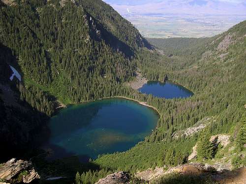
Ashley Lakes...
Two or three hours after finally being able to phone out (that is, sometime in the middle of the day) there was difficulty when it became clear that it would be necessary to find, and then retrace, our route from the previous day. Even though it eventually led to the lake, Ashley Creek was impassable due to large boulders, and what would have been a difficult—if not impossible—descent down the waterfall even under the best of conditions. The only way out was to climb through the dense forest, hoping to eventually pick up the game trail used the day before, as it led to, then provided, the only way through some quite serious cliffs. Time after time we thought to have discovered the trail, only to have it disappear a short while later, at which point the struggle continued through the dense undergrowth—sometimes climbing, sometimes descending (more often than not, climbing)—checking the GPS all the way, trying to find a matching point that would prove accurate and lead to the only trail providing passage for an individual with one good leg. As Duane was to write later, "It seemed to me that we would never find the safety of that path and there was no other visible way through the cliffs."
Somehow, as with everything else that day, we pressed on, to eventually find that negligible, overgrown, absolutely essential game trail, and then slowly made our way through the cliffs…to at last come out on a high point where it was possible to look out and (finally!) see our destination, see the thin strip of land between the upper and lower lakes, and knowing the trail out took off from somewhere in the vicinity of that separation, began looking for a way down to water. I think it was then that it hit us that maybe—just maybe—we were actually going to be able to pull this off; we were really going to make it.
It was, however, still a long and difficult circumnavigation because progress, and investigation of gully after gully, revealed the way at some point to be blocked by cliffs, or else it was simply too steep, making it necessary to move on, at cross purposes against the slope, through the mounting heat, the last of our water gone with the underestimation—after all, it appeared so close below us; maybe a thousand feet, which at that moment could be rationalized as just a hop, skip, and jump!—of just how long it would take to reach the lake. Finally, a way down looked to be doable...and so began a long, tortuous descent through a ravine full of sun and heat, and stones and slippery grass, under what can only be described at that time as a blazing afternoon. That descent was interminable, made even worse by the tantalizing water appearing so near, yet approaching so slowly. And while working our way down, little did we know—we had no way of knowing!—but that final descent was not to be the worst of the day. To reach the lake it would be necessary to first pass through a thicket of alders. Those alders at lake’s edge were to be the worst.
Our view of the Ashley Lakes from above.
From above, and while still at a substantial distance, the thicket appeared to be not all that bad. At least, looking at the forest and lake just a stone throw away from where it would be necessary to confront the alders (certainly, such a beautiful, inviting green couldn’t really pose all that great a difficulty), it was easy enough to will it that way. But wishing doesn’t usually have much effect on that sort of reality, and once again in the life of climbing, assaults on the senses by the likes of fatigue, thirst, hunger, and heat (and—at least in Bob’s case—pain...and you know, he didn’t complain even once the entire day) had led to a false reading of what we were seeing before us. That alder thicket was the most difficult, the most unpleasant, thing I have ever encountered in my life! And a very long stone throw, indeed!
All we wished was to reach the lake. Which, of course, eventually did come to pass. Duane led the way, Bob was in the middle, with me bringing up the rear. I don’t know how Duane managed; in places the thicket was at least ten feet high, with unyielding "trees" (if such they were) a couple inches in diameter; sometimes the bushwhack took us through a landscape more "whiplike," similar to a willow thicket; there were times of crawling over, under, and around branches high enough the ground could not be seen below. And the line through this god-awful maze was not straight, but tortured and crooked. I remember calling out one time, a cry of heat and thirst and fatigue and (by now absolutely awful) blisters, and the stinging nettles I’d just crawled through, yelling something helpful like, "head straight for the lake!"—as though he wasn’t trying to do just that! To his credit, Duane (and Bob) maintained a dignified silence, probably just what I needed because then I shut up and crawled. It is amazing how much larger that alder thicket was when seen from within, as opposed to its outward appearance! Eventually, somehow, I staggered out to the lake. We had reached our goal. Duane was already filtering water.
And that was the worst of it. A little searching, a lot of drinking (not necessarily in that order), and we picked up the trail, not knowing for sure how far it was yet to the trailhead, but it turned out to be maybe four miles. In places it had not been cleared, so a lot of deadfall had to be dealt with, and there were several areas of muck and mud to get through, but no matter—it was the trail! And we lost more elevation, then had a last climb of well over a thousand feet up a ridge, but upon attaining its summit, there, barely shining in the last light (and just minutes away from having to put on our headlamps), was the unforgettably beautiful sight of Bob’s truck. The end of a 16-hour day with almost no food. On the heels of the previous day’s 13 hours and no sleep. I love Bob’s truck! And I take my hat off to the amazing effort from my two friends in leading us out.
In Tribute
On March 1, 2011, Vernon Garner, Saintgrizzly, left us after losing a bold, inspiring fight against pancreatic cancer. Or maybe he won, for he is at last free of his pain and has "shuffle[d] off this mortal coil."
Vernon was an important contributor on SummitPost, but beyond merely making good, informative pages, he actually inspired many who read his work. No one put more work into his or her pages than Vernon did, and many of those pages, especially those related to Glacier National Park, the place he loved above all others, are works of art in both the writing and layout. More than one person has wanted to visit Glacier or go back to Glacier largely due to what he shared about that magnificent place.
Many people on SP counted Vernon among their friends, and many more saw him as one of the best, one of those who exemplified the spirit of this site. He was one of the best of us, he will be missed, and he will not be forgotten.
As a tribute to him, Vernon's pages will remain in his name.
Nicely done Vern. And I finally get to see your photos. They're terrific!
I noticed that you didn't put in a link to my profile page, so I supposed you were allowing me to decide whether or not I wanted to be identified as the injured party.
Happily I was back out hiking (gingerly) in only a couple of weeks, and back to pretty much full strength by the time of my October climb of Boundary Peak. Getting old really sucks!
Powerful tale, and beautifully written, Vernon. The narration has a dreamlike quality to much of it, and that fits perfectly with your eloquently worded descriptions of your memories of those days. This is both inspiring and humbling, and I hope everyone reads this. It could happen to anyone.
I'm glad you all made it safely and without lasting harm, and it is great to see that you have also maintained a sense of humor about it, easier to do since it was a happy ending.
It was Bob who got me back into mountaineering and I have also had the opportunity to hike with Duane. Both of these guys are so very knowledgeable when it comes to backcountry situations and I learned the value of a GPS from Bob when I thought all you ever needed was just a map and a compass. I hiked with Bob, not long after he suffered that injury and the guy still outhiked me. Amazing. Thanks for sharing your adventure and the pics are
a great addition to the telling.
...slide alder too. Well done you guys for keeping cool, collected and working through the problems. Does you great credit as does such a well written article.
Great Post...I have been evaluating a ski descent on the N. face of McDonald for a couple years now on a line that I think would go with a rap exist during a good year. Does anyone have any pics of the North face in winter, summer, fall, spring? Preferably from the McDonald glacier. Thanks in advance!
-Jeff
Never been there before but after seeing your page its definately on the "To Do" List. Excellent job as all your pages are. I am glad you guys made it out in the shape you did and not any worse.
Epic trip report! Being from the Mission Valley, McDonald is constantly on my mind. I would hate to be stuck down in Grizzly Basin with a bad leg.
Did you consider doing an approach from Sheep's Head, following the ridge line up from the trail head?
Hoping to get up in that area and in particular Mollman Lakes within the next year or so. Heck of a commute from Colorado, but looks amazing. Great job on the page too.
Parents refers to a larger category under which an object falls. For example, theAconcagua mountain page has the 'Aconcagua Group' and the 'Seven Summits' asparents and is a parent itself to many routes, photos, and Trip Reports.


Comments
Post a Comment