It was a very cold morning, so cold that we were hitting record low temperature in Los Angeles and even received frost in some areas. At 7:30 AM we met at the Heaton Flats Trailhead along the east fork on the San Gabriel River, north of Azusa in the San Gabriel Mountains. One week ago over e-mail I had suggested hiking to Allison Mine from the Iron Mountain Trailhead. I had talked with a fellow hiker once on the way to Iron about this hike and I had always wanted to do it. We researched the trip and it seamed reasonable. The descriptions online rated it with an ACA rating of 3A III, we all had experience canyoneering and either had or could borrow the equipment needed. Trip Confirmed!
So we (Tom =Bechtt, Augie = Mountain Impulse & me = Travis_) started our hike as you would to summit Iron Mountain and made it to the saddle just before the steep ascent to Iron by 9:30 AM. Up to this point we had been hiking with Bob Burd who then continued on to summit Iron Mountain. The trail to Allison Mine heads west from this saddle, it is a little hard to find the start as it is well hidden and the trail is fairly overgrown. Immediately the trail narrows and becomes hard to distinguish in spots, not to mention that the slope is very steep and it is a long ways down if you loose traction. I am open to the adventure but immediately start to wonder what we have gotten ourselves into. We encountered snow in shady areas on the way up and I thought that these steep slopes with narrow trail plus snow could be a bad combination. But we persist. Luckily someone had trimmed the Yuccas, otherwise some areas would be impossible to get through without multiple stab wounds. Even though the trail was worn out and overgrown, it was easy to follow and in some areas was still in good condition, even with carefully constructed rock walls. The views were beautiful. We crossed into several microclimates, some areas had ferns and lush trees, others were dry with cacti and yuccas. We did come across snow, but it wasn't very deep and other than a few sketchy crossings over worn out trail sections and some pretty heavy bush whacking we made it to Allison mine in relatively short time.
Allison Mine
Allison Mine Wreckage
Allison Mineshaft
We stopped for lunch at the mine, explored a little ways into the first mine shaft, commenting on how these earlier miners must have been crazy. The shafts appear to go back a long ways, but the opening narrows in some spots to where you would need to snake through or you need to cross one of the many vertical shafts in order to continue. There was evidence of the mining operation all around, rail track, pipe, an old engine, wooden structures ready to fall down into the canyon, roofing, etc. All the way down the canyon you would see evidence of the mine upstream, a piece of roof here, some pipe there. As Tom said, "just like the gold, everything eventually washes downstream".
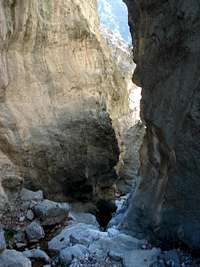
Descending Allison Gulch
A loney Tree and Steep Canyon Walls
View above 2nd rappel
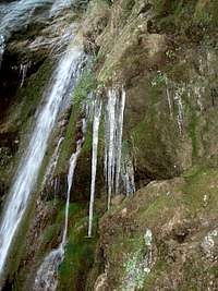
On the trail to the creek in Allison Gulch, which we were following all the way to where it joins the east San Gabriel River, there were 2 additional mine shafts. I couldn't help think that if there was enough gold to make all of this effort worth while, there still must be a lot here. Anyway no time to search for gold, our mine exploration had ended and the canyoneering portion of this trip begun. Shortly down the gulch (Definition: a small rocky ravine, especially one with a fast-flowing stream running through it) we encountered the first obstacle. We could not find any anchors so figured this was to be down climbed. I explored ahead, climbed around to the side and then shimmied down a dead tree to the bottom. I encouraged Tom to try down climbing this one portion of fairly slick rock, since I was below I was able to get beneath him and help with his foot hold. However, his hand hold failed and Tom came falling onto me. Amazingly, I was able to arrest Tom's fall and prevent him from getting wet in the creek. After exporing one dead end (which I suggested, sorry Augie) Augie ended up climbing down the same tree I did. I continued ahead and found our first rappel shortly down stream. While I was waiting for Augie and Tom, I pulled out my harness, carabineer and figure 8 that Tom had lent to me. I had not previously used a twist lock carabineer nor figure 8, and with my cold hands (remember, it is well below freezing, ice everywhere) I fumble the figure 8 and "clang" "cling" "ploop" it falls part way down our rappel and into a pool of water. Tom hears the noise from a short distance away and asks, "that was not the figure 8 was it". To which I sheepishly replied "yes, but I can get it". Very luckily, it did not fall all the way over the falls but bounced back into a pool of water. I was able to down climb the beginning section of the rappel and get it, however I encountered a rock covered with very slick ice, slipped and smashed my shin. Ouch. Nothing worse than smashing your shin. Lesson learnt, do not put you gear on at the top of a rappel and be very careful handling gear with cold hands. We all put on our gear and double checked each other and complete the first rappel without any significant issues. The icicles at the bottom of the rappel were amazingly beautiful and foreshadowing more ice to come.
Things start to get Complicated...
Auggie rappelling
icicles below rappel
We pack up and head on further down the canyon to our second rappel. Immediately I see a problem. To get to the top of the waterfall for the rappel you are forced to wade through a large pool of water. Holy crap! This was not taken into consideration for this trip. Now that we sit there looking at this pool of water I remember reading a brief comment online how you may get wet during sections of this trip. I should have heeded that comment a little more. Even though it is well below freezing and getting a little late in the afternoon, "we are OK", I say to myself. I take my shoes off and wade through the pool. It was only 2 or so feet deep but by the time I get to the top of the rappel my feet are numb. Requiring me to put my shoes and socks back on immediately and I pull out a couple of my chemical hand warmers and stick them in my shoes. After I am done dealing with my feet, which are still numb, I finally look down the waterfall at our rappel path. Double Holly Crap! Ice everywhere and the only way down is to rappel through the waterfall into a large pool at the bottom. After Tom and Augie make it across the small pool, also putting socks back on to warm their feet, we all consider how we are going to get down. Option 1) Rappel down in our shoes and have wet feet the rest of the day, possibly frostbite?? Option 2) Rappel down in bare feet, probably losing traction and slipping into the falls, hurting, numb feet?? Option 3) Luckily I brought an extra pair of boots, we could all use my spare boots, taking extra time to tie the boots to the rope and pull back up, changing shoes, etc. 4) Option 4 was to retreat, but we had already rappelled and were committed to this route. We chose option 3, realizing that this is going to add time and we will probably be hiking out in the dark. But in these temperatures hiking out 4 + miles with wet feet could be bad. So Augie goes first, wearing my oversized boots and knocking off a lot of the ice while trying to get traction on the center portion of the waterfall that was not directly in the water flow (but was very icy). At one point he had to straddle the water fall while getting a pretty heavy mist of water. He also got wet almost to his waist getting out of the pool below. After Augie's rappel he put his socks and shoes back on to warm his feet, then tied the boots to the rope so I could hoist them back up for Tom's rappel, which was repeated again when Tom was down so I could use the boots. During my short rappel, and after hoisting my boots up to the top twice, with wet rope, my hands were getting numb. This made it difficult to control the rope and I hastened my rappel a little before they went totally numb, but I made it down safely. All of this took a lot of time. Finally, a littler wetter but with fairly dry feet, we hiked back to the next rappel trying to get our blood flowing and warm our numb feet.
The Big Rappel
The Big Rappel
The final rappel was a short distance further down the gulch and was by far the longest of them all, looking to be somewhere around 80 - 100 ft. It also looked to require rappelling directly in the waterfall and ended in another pool of water. We started our process again, this time having to tie the 2 x 30 meter ropes together, one of which was a static rope and the other dynamic, which resulted in some bouncing while rappelling. We followed the same system as our previous rappel. However, we were not able to confirm that the rope were long enough. The info online said 200 ft rope was necessary, we had 2 x 30 meter which tied together were slightly short of 200 ft. We tried to get a view to confirm the ropes were in the pool at the bottom but couldn't. We tried to recoil the rope and throw it out further in view but the ropes swung back out of sight. Augie, figured he would start the rappel anyway, and if he could not confirm the ropes in were in the pool (long enough) he would use his ascender and inch his way back up the rope and would have no choice but to tie the rope and rappel down a single rope with a prussik backup to get over the knot (and leave behing the rope, I guess). Luckily (thank god!) he confirmed the ropes were long enough (saw them in the pool) and continued all the way to the bottom. Augie made it down and called up stating that the water was 2.5 ft deep at the bottom. I went second this time, because my hands were still cold and I wanted to get down. The rappel was not overly difficult but it was long, and my hands were numb. This, combined with the dynamic rope, made for a jerky rappel. The water at the bottom was cold, but it was weird, it didn't even really register in my mind as being cold. I guess my whole body was freezing and I was just happy to be done, put on my warn socks with the chemical foot warmers. Tom also made it down with no problems, we all dried up, dressed, packed up the gear and went on our way.
Back to Parking Lot by Dusk.
Allison Gulch looking towards Iron Mountain
It was now 3:30 pm and it would be dark in 1 to 1.5 hours. We made the best time we could going down the gulch, but it still took a long time and was starting to get a little dark by the time we reached the East Fork of the San Gabriel. We were all pretty proud at having dry feet when we realized that we had to cross the East Fork river, likely multiple times, in order to get around areas of the river that were bordered by cliffs. The first crossing was tricky, there was a lot of water flowing and most of the rocks you could use a stepping stones were covered with ice. I managed to poke the ice off some of the rocks with my hiking poles and jump across. We ended up crossing approx 10 times to avoid obstacles and our feet were no longer dry. Some of these crossings were tough. My right foot got wet, but we were close to the cars now and didn't care. We were hiking at a fast pace and had no problems staying warm. We continued down the river, which seems to go on and on, and finally made it back to our cars just as it was getting dark at 5:15 pm and just as the wind started to pick up and the temperatures drop even more. It turned out to be a 10 hour trip. I was expecting to be back around 2 or 3 pm. It was a great trip, but I definitely underestimated the difficult of these rappel in the cold, the distance we needed to cover and the time this trip would take. My wife questions my sanity after showing her the videos and pictures, saying, "this is fun"? But yes, it was!
Video of Tom and Augie Rappelling Allison Gulch
Video of Travis Rappelling (just rotate your head 90 degrees)
Thanks, and thanks for adding all the great pics. So what will be our next adventure?? Looking at the pictures of Allison Gulch, it looks like it could possibly be climbed to the summit of Iron Mnt.
Travis and Tom did the route a little over a week ago; I wasn't able to go with them, so it's still on my list. I'll keep you posted. Check out Travis's TR "SW Ridge to Iron" currently on SP's front page.
Nice writeup Travis. It was fun hiking with you to the saddle. The freezing hands makes me glad I didn't join you - I'd had enough of that already during the weekend. I took a very close look at that gully on my way up to the summit, and it sure looks like it would go the whole way at class 3 or less. Maybe a good springtime adventure?
thanks! your excellent trip report for the north face of telegraph was actually the inspiration for me to suggest trying allison gulch to the summit of iron mnt. i like bob's suggestion to try it later in spring.
We met on the Heaton Flat Trail on your way to Allison Gulch.
You should have seen the Allison Mine Trail a couple of years earlier. It was impassable at the start without hedge clippers for the yuccas, and then I had to lean out over the edge holding onto spines of a later one even after clipping. It had a few fallen branches this year, no big deal. The Rattlesnake Peak trail was a little better yuccawise, but may have deserved a dubious rating as second toughest peak in the SGM. That one was a LOT of work.
I have seen only the mine and the eerie base of the final waterfall, and thoroughly enjoyed your description of the interim.
yes, I remember talking to you. I was pleasantly surprised that the trail was as good as it was. I saw many spots that if the yucca were not trimmed that a maneuver such as you described would be necessary.
Parents refers to a larger category under which an object falls. For example, theAconcagua mountain page has the 'Aconcagua Group' and the 'Seven Summits' asparents and is a parent itself to many routes, photos, and Trip Reports.


Comments
Post a Comment