A long day on the Sleeping Lady
To acclimate for Iztaccihuatl we first climbed La Malinche for which I did a separate trip report:
https://www.summitpost.org/trip-report/376073/la-malinche-with-utm.html
After returning to TAPO bus station in Mexico City we then rode a bus to Amecameca. The bus line is called Volcanoes and a bus leaves every 15 minutes at a cost of 22 pesos. The trip to Amecameca takes about an hour and 20 minutes. About a block past the bus station is Amecameca’s main square.
At the first corner of the main square is a gas station and a Bodega Aurrera, which is a modern grocery chain store owned by Wal-Mart. While this might be the place to buy package goods, the fresh food market is also on the main square. You will be able to buy fresh fruit and bread and there is even a bulk meat area inside. There are also several cooked food vendors.
Across the square is the San Carlos Hotel where we stayed and next to it the National Park office. The National Park website has some useful information. http://iztapopo.conanp.gob.mx/ing/turismo_ing.php
The San Carlos Hotel is very basic. We got a single room for 100 pesos a night. They had doubles and triples ranging in price up to 280 pesos per night. Our room didn’t have a TV, that would have been extra. It also didn’t have a toilet seat or a shower curtain. The water did get hot after running for a long time. There was no restaurant and bell hops would have been a fantasy. Because it was so cheap we kept our room while we went to the mountain so we could store our stuff. They apparently also have a closet that climbers can store some things in. We wanted the comfort of knowing we had a hot shower and a place to sort things when we got back.
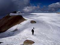
![Izta from Hut]()
The desk person at the hotel will help you find transportation to the mountain. That wasn’t necessary. When we were at the National Park office we were approached by a driver named Guadalupe. After arranging with Guadalupe to have a ride the next afternoon at 1:00 we were approached a few more times. Guadalupe had a colectivo van which had enough room for our gear. The cost was 300 pesos for our group of three. We also arranged that he would come back and pick us up the next day at 4pm. Make it a point to have exact change since it’s unlikely the driver will have the ability to change larger notes.
We registered at the National Park office at a cost of 20 pesos per day per person and we also secured the night at the Altzomoni “lodge” for 20 pesos per person. We were given wristbands to prove we paid. We showed these at the Visitor Center at Paso de Cortes where we were given keys to the hut.
We had the hut to ourselves. The hut is part of a large facility of transmission towers. I heard some voices to indicate the facility wasn’t as deserted as it seemed.
The hut has three rooms with 8 bunk beds each. There are two bathrooms and a hallway. One bathroom had running water, the other was a bucket flush. There are electric lights and wall outlets. Each room has a fireplace.
I had to leave an id as security for the keys. Because of that arrangement I felt comfortable leaving our gear there while we climbed. When we returned after the climb there was another party at the hut.
The hut is about 2 km from the trailhead. It is also on top of a hill, which means regaining a couple hundred feet elevation on the return. We were able to get our arranged ride to pick us up at La Joya and take us back to the hut.
For a map I’m fortunate enough to own a paper 1:50,000-scale topo sheet that covers Iztaccihuatl and Popocatepetl. I made a 2X color 11 x 17” photocopy of the Izta area. I labeled the UTM grid and added additional elevation labels to the contours. The coordinates I give are UTM on NAD27 Mexico, zone 14, latitude band Q. I collected them with a basic model yellow Garmin eTrex. I usually didn’t give them a lot of time to settle. Use them at your own risk!
I did label the map with some additional information, which I found hard to discover before the trip. My hope is that this will prove useful to other climbers.
There is a government map store at the Mexico City airport. They no longer sell paper maps, only digital.
At 10 minutes past midnight we started our hike from the hut 536485 2113976 elevation 13226’ 4031m. It’s a couple kilometers along a road to get to the trailhead at La Joya 536824 2115795 el 13106’ 3995m. For those driving from the Paseo de Cortes, there is a triangle intersection at 536454 2114358 el 12982’ 3957m. At this intersection it is a left turn to the hut, and a right turn to La Joya.
There’s not much at La Joya. A parking area and a couple structures that could be best described as open sided stables. I would only consider them to be emergency shelter, not something to plan to stay at.
The trail starts uphill right away. After gaining a few hundred feet it becomes less steep. At first the mountain is on the right side of the trail. The trail is braided and has a surface of fine soft dirt. This is as good as it gets!
At 537334 2115996 el 13452’ 4100m the trail passes through the Anteportillo. The mountain is now on the left and the trail becomes rockier. From here until the Grupo de Los Cien hut, the loose places tend to more a pain on the way back down than the way up.
Portillo de la Guglia is at 537953 2116724 el 14391’ 4386m. There is a memorial to a Canadian woman on the left as you pass through. It is a blue box attached to the rock. After this pass the steeper mountain side, which is the Feet, rises on the right.
The next pass is Portillo de los Pies at 538305 2117271 el 14871’ 4533m. This is the saddle between the Feet and the rest of the mountain. After passing through, the mountain is again on the left and the Feet are behind.
The trail curved down a bit before rising back up, so I jokingly declared that must be the outline of her calves. A sharper turn to the left meant a steeper uphill before topping over at 538147 2117785 el 15461’ 4712m. After this the hill is then again on the right. There is a high point before losing elevation to arrive at Grupo de los Cien Hut at 538178 2117999 el 15505’ 4726m.
The route now takes on a different character. The next section is the scramble up to the Knees. Staying closer to the ridge line means some scrambling in places. The other choice is to move off the ridge to the left into some annoying loose stuff that might not be as exposed. On the way down we deliberately slid down much of the way on this stuff rather than scramble closer to the ridge. The hazard however is not to slide down too far or you will get cliffed out. Also the sliding had its own injury risk with some steep rocky areas mixed in.
On the top of the Knees is the ruins of the Luis Mendez hut at 538196 2118634 el 16561’ 5048m. Now it’s time to experience what you will remember Iztaccihuatl for, all of the up and down. There is a choice of a short scramble or a loose area to get off of the knees. Then it is a fairly straight forward hike over to the high point just before the Belly Glacier. 538084 2119102 el 16795’ 5119m. A lesser high point to the left is skirted on the way.
After passing the high point just short of the glacier we put on our crampons. They remained on until we got back to this same place. There was a bit of a crevasse close to the near side of the glacier. We could see where others had crossed it at a bit of a packed down place. After that we headed straight across staying to the high line. There were several narrow cracks in the glacier, but nothing that was gaping. Do not stray too far to the west side. It drops off dramatically. You will see this when you look back further on.
The glacier drops down some in the middle before rising back up again. After arriving at the other side it is a left turn to go to the summit. Before making this turn we had to negotiate a small snow cliff. Again we saw where other tracks had found the easiest way up.
There is a narrow stretch of ridge with some up and down before the final push to the first summit. This is a place where some might want an axe. We chose to stay with our ski poles because it felt more secure. It is definitely a place to watch your step!
At the 5100m contour we started the final ridge to the summit. The ridge was mostly bare of snow. Sometimes we got to choose between some loose stuff or rock scrambling. There were a few places where there was little choice and some exposure. We topped out on the first of three summits at 537816 2120155. From here the other two summits can be seen. The three summits were bare of snow and rose above the summit glacier.
![Izta West Summit]()
![Izta Summit North]()
I visited all three and the GPS was not definitive as to which one was highest. One of the summits 537481 2120284 is off to the west north west. I got to it by following the high line of the crater. I only spent a moment on top of this summit before heading off to the third and most northerly summit at 537644 2120575. I made it a point to move away from where it drops off to the left for this leg. This third summit has a cross on top and general consensus apparently calls this one the highest. It is where I got the highest GPS readings of around 17138’ 5224m. It should be noted that while we stayed on the summit the readings dropped down to below the highest readings I got on the other 2 summits. The low end of the summit readings was around 17120’ 5218m.
To return to the first (south) summit we travelled straight across the middle of the summit crater glacier. The crater glacier slopes away to the north east so the rim is probably missing there. When I climbed Iztaccihuatl in 1994 the snow was higher than any of the crater rim. Both the summit and belly glacier have melted down considerably in the past 14 years.
The return from the summit is notable for having to regain elevation several times. Also because of the loose volcanic rock it can be treacherous in places. I recommend having trekking poles for this mountain. Crampons are recommended for the glaciers but they also helped on some of the loose dirt in steep places.
One feature of climbing Izta is all the great views of Popo throughout the day. Popo has been closed to climbing since volcanic activity increased in 1994. When I climbed Izta in January 1994 my reasoning for climbing it instead of Popo on that trip was: it would always be easier to get somebody to go back to Mexico to climb Popo with me than Izta!
Even in 1994 I could smell sulfur from Popo when I climbed Izta. On this day in 2008 we started off to the smell of forest fire smoke. In some of the pictures you can see the smoke drifting west while the emissions from the crater drift east.
It was a long day for us. We left the hut at 10 minutes after midnight. We started up the trail at La Joya at 1:00am. We were on the third summit at 11:00am. We got back to La Joya at 4:00. That’s not making great time. Several parties will do it in less.
Keep in mind however if you underestimate your time you could be spending an extra night up there. The park closes at 6:00 pm. If your driver doesn’t wait, there won’t be anybody else coming along.
We had a full moon for the hike. It was bright enough I didn’t need to use my headlamp. The weather was great. There was a little wind up high, but nothing of concern. I was never cold. On the way down I would have taken off more layers if I had more room in my pack.
For those who want to shorten summit day by camping, be advised there is no water along the trail. I didn’t see any dependable snow prior to the glaciers. You will have to pack it all. I did see various tent sites along the path before and at Grupo de los Cien Hut. The Grupo de los Cien Hut is the only habitable hut I saw on this route. Aside from the water issue this is not a path I would want to wear a heavy pack on.
We were a party a three. My wife, and Tyler who contacted me on 14ers.com. We agreed that having done La Malinche 14550’ and spending two nights at 10000’ first helped immensely with acclimation. Although the hike itself was very demanding we had no altitude issues.


Comments
Post a Comment