Overview
| What: | One day ski trip to summit of Coffin Peak |
| Where: | Uinta Mountains, Utah, 4.3 miles ENE of Gilbert Peak |
| Length: | 21.6 miles round trip |
| Coffin elevation: | 12,673 feet |
| Elevation gain: | 4788 feet |
| Start location: | Henrys Fork winter parking |
| Date: | April 12, 2008 |
| Round trip time: | 15 hours, 6am to 9pm |
| Time to summit: | 9 hours |
| Participants: | MOCKBA, Rob, Mike, and myself |
Planning
![Gunsight and Gilbert as seen from Kings Peak]() Gilbert and Gunsight
Gilbert and Gunsight![Strong Winds]() Henrys Fork Peak is on the right in this 2006 picture from Joe Bullough
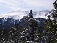
Henrys Fork Peak is on the right in this 2006 picture from Joe Bullough![Coffin ridge]() Coffin Peak
Coffin Peak![Anne Peak, 12723]() Anne Peak
Anne Peak
Shortly after the
marathon one day 30 mile round trip ski to Kings Peak 13528, Utah's high point, discussion turned to our next adventure. Various ideas were kicked around but no one seemed psyched to do anything major the immediate weekend after. A week went by and we finalized plans for another trip starting from the Henrys Fork winter parking area. We weren't sure exactly where we'd go, we just knew it would be some place high. To get to a peak over 12000', there wasn't much choice as to where to start since other approaches were still snowed in.
The available peaks from Henrys Fork were the 13000 footers
Gilbert,
Gunsight, and
Henrys Fork Peak, and two 12000 footers, Coffin and Anne. After the long slog to Kings Peak two weeks earlier I was hoping for Gilbert, the second highest peak in Utah, simply because it seemed the most straightforward. If you went the most direct way it was a 12 mile one way 4500 feet elevation gain along a well defined route at a steady grade. Gunsight Peak wouldn't have been much harder, being only a mile farther away. Henrys Fork Peak was the most interesting, but would be technically the hardest, requiring a steep climb up a slope that could potentially avalanche, followed by a stretch on an exposed ridge. Coffin and Anne were intriguing because of their remoteness. I doubted they saw much, if any, action even in the summer and wondered when the last time someone had climbed them. I speculated that most Utahns had never even heard of them.
That week saw a couple of weak storms pass by and we expected a few inches of fresh snow. I wasn't too keen on doing Henrys Fork Peak with any fresh snow on it and was relieved that the guys weren't into it either. They had already done Gilbert on skis a few years back and I had hiked there one summer. The approach to Gunsight is just like Gilberts. Something new was in order, so we decided to head towards Coffin and Anne. Our only definite plan for the day was to head for the rim of the West Fork Beaver Creek drainage and then decide for sure. We would most likely head toward Coffin, but Gilbert would still be an option.
Coffin would be difficult because of the rolling off trail terrain and the route finding. A nice steady climb on a well defined route is a lot easier than threading your way up and down through the trees and brush. In my opinion a lot of little ups and downs suck up more energy than a steady climb of the same elevation.
The Trip
![Only 9 hours to the summit :)]() Let's get going! Let's get going!
![Forest Road 077 on the way to Coffin Peak]() Forest road 077 Forest road 077
We drove up Friday night, camped out, and got underway just before 6am the next morning. The temperature was a brisk 8 degrees Farenheight. Earlier in the week ridiculously warm weather had been expected, but each passing day brought a lower predicted high. Instead of slogging through mushy snow, it looked as though conditions would be just right.
We headed south on forest road 077 for 2.8 miles and then hung a left onto forest road 082, which we followed a short distance until right before Joulious creek. We left the nice gentle road, put our skins on, and started climbing along the west side of the creek. It started out steep and brushy, but before long the terrain mellowed and the trees thinned out.
|
![MOCKBA]() MOCKBA breaking trail MOCKBA breaking trail![Gilbert as seen from Deadhorse Park rim]() Rob and Gilbert Rob and Gilbert
When we hit the sun, I stopped to put on sunglasses and dig out some frozen sunblock with my fingernails. I thought only a rookie wouldn't think to protect it overnight. But, at our breakfast stop I was amused to find that when everyone else tried to put on their sunblock, theirs was all frozen as well.
We followed the creek for about a mile, crossed it, and then contoured around hill 10552. MOCKBA, our navigator, would give the lead skier directions such as "Keep the sun 30 degrees to your left". There was a bit more snow than expected, around 7 inches, so trail breaking was not as fast as we would have liked. But, nevertheless, we made steady progress upwards until we hit the ridge dividing the Joulious Creek drainage from the West Fork Beaver Creek drainage. We lost about 500 feet of elevation and elected to keep our skins on since this section was steep, the trees were pretty dense, and we'd have to put them back on shortly anyway.
|
![Anne Peak, 12723]() Anne Anne![Coffin Peak]() Coffin Coffin
Soon, we received our first glimpses of where we were heading, Anne ringed with cliffs, Coffin a long skinny sloping ridge. The temperature was very comfortable by this point and never got overly hot. Talk turned to what specifically we would do and the consensus was we'd definitely do Coffin and most likely Anne as well. I think someone even mentioned the possibility of doing a big loop including Coffin, Anne, and then going all the way to Gilbert. I didn't think this was going to happen, but we'd see.
|
We crossed over some gentle terrain in the West Fork Beaver Creek drainage and then began our ascent to the top of the Coffin ridge. We had great views of Anne Peak and Queens Cirque. It was steep at first and soon became rocky. From about 11000' to 11200' the snow was melted out and blown off so we carried our skis. It got better after a short climb and we reached a gently sloping plain which took us all the way to 11800 feet. We skied across the broad white expanse never seeming to get closer to our goal. Finally, the terrain steepened and we made it about another 200 feet up to 12000 feet on the skis.
![Base of Coffin s NW Ridge]() Time to carry the skis Time to carry the skis
|
![NW Ridge of Coffin Peak]() Just a few trees left Just a few trees left
|
![Queens Cirque]() Queens Cirque Queens Cirque
|
|
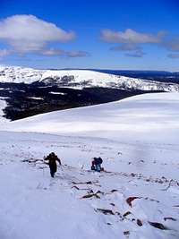
Mike was a little ahead of me and stopped to ask what I was thinking. By this time the wind was kicking up and the way ahead looked like it was going to be rocky and require booting. It was around 2PM and I replied that I'd be happy to turn around at Coffin and forego continuing to Anne which was 2 miles farther along the ridge. We didn't really want to carry our skis up the rocky part to Coffin only to decide then that we weren't going to Anne and have to carry them back down. I reached MOCKBA and Rob at the start of the rocky part and no discussion was necessary since without a word from me, MOCKBA also suggested turning around at Coffin. So, we ditched our skis and began booting the final .8 miles to the summit.
![NW Ridge of Coffin at 12,000 ft]() Mike begins the final push Mike begins the final push
|
![View North towards Hole-in-the-Rock]() View north towards Hole-in-the-Rock View north towards Hole-in-the-Rock
|
![Windblown snow of Coffin s ridgeline]() Ocean waves in the snow Ocean waves in the snow
|
|
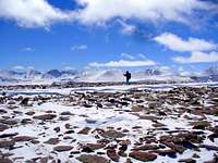
The terrain to the summit was a mix of hard snow, sink in to the calf snow, and rocks. When I was breaking trail through one of the soft spots, I would veer left and right, searching in vain for some solid snow. I kept looking back to see if any of the others had lucked out and found a magic ribbon of supportable snow, but it never happened. If I was sinking in, they were too. Fortunately, most of the way was on rocks.
The wind increased as we approached the summit. I thought that it was even windier than it had been on the Kings Peak trip two weeks earlier. Everyone has different tough it out tolerances, but eventually, we all caved, and each of us separately picked a spot to crouch down and put on more stuff. The blowing snow swirled all around as we made the final steps toward the top.
![Up along the rim of Middle Fork Beaver Cirque]() Mike on one of the hard pack sections Mike on one of the hard pack sections
|
![Mount Emmons - view from Coffin s Ridge]() MOCKBA and me with Mount Emmons behind MOCKBA and me with Mount Emmons behind
|
![MOCKBA and Rob fighting the blowing snow]() MOCKBA and Rob fighting the blowing snow MOCKBA and Rob fighting the blowing snow
|
|
We arrived shortly after 3PM, 9 hours after we had started, to find an impressive looking cairn awaiting us. This was not just your typical haphazard bunch of rocks piled together. It was about 6 feet high and considerable effort and skill was involved in erecting a stable structure that has withstood the elements for 50 years or so. I wanted to go to the high point first, a few yards away, and then go back and check out the cairn, but each step brought an increasingly better view and I just kept on going, forgetting all about the cairn. The summit was flattish and all around was a vast panorama of Utah's highest peaks: Kings Peak, Mount Emmons, Gilbert Peak and others.
![Summit cairn of Coffin Peak]() Mike and the summit cairn Mike and the summit cairn
|
![Uinta 13ers, Kings to Gilbert]() What a view! What a view!
|
![Mike, Rob, and MOCKBA on Coffin Peak]() Mike, Rob, and MOCKBA Mike, Rob, and MOCKBA
|
![Looking se from the summit of Coffin Peak]() View southeast towards Shale Creek View southeast towards Shale Creek
|
|
We left the summit and none of us regretted our decision not to go to Anne. The way down yielded fantastic views of the huge cornices overlooking Middle Fork Beaver Creek. By the time we reached our packs, the wind had calmed and we took a much deserved break. Rather than descend from the broad plateau the rocky way we booted up, we found a better route more to the south between the trees where there was still plenty of snow allowing us to ski down to Lake 10930.
![MOCKBA descending Coffin Peak]() MOCKBA descending MOCKBA descending
|
![Descent to our stashed skis]() Heading down to our stashed skis Heading down to our stashed skis
|
![Descent path to Lake 10,930]() Our descent route to Lake 10930 Our descent route to Lake 10930
|
|
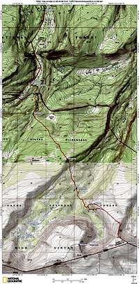
![Topo of trip]() Topo of trip
Topo of trip
Unlike the Kings Peak trip, getting out on this trip involved some work. There were several ups that we had to tackle, the biggest of which was a steep 500 ft gain that necessitated our putting on skins. Also, assuming you drop your skis before Gunsight Pass, Kings Peak is a nice gently sloping glide on the way out that requires no turning. On this trip, there were several sections of steep crusty snow that I had some difficulty with. I did a lot of zigzagging combined with some tedious kick turns. Maybe next year I'll perfect my downhill technique.
I was hoping to get the off road part done while it was still light. Many of our trips have finished in the dark, but in all except one, we reached easy terrain before we had to turn on our headlamps. Earlier in the year we had had a trip where we were skiing a narrow gulley and route finding in the pitch black and I didn't want to repeat that encounter. We made it to the road sometime after 8, still light, woohoo! On most trips I go on, there's always a point on the descent where there's a definite spot where I feel I've made it and nothing could possibly go wrong. This was it. There was another 3 miles of easy flat skiing back to the car. We made it out just before 9. There was about a three quarters moon, strong enough to cast a shadow and we didn't even need to turn our headlamps on.
In the pretrip planning it had been thought that we'd be out by 6 or 7. Well, not quite, but close enough.
Participants
Miscellaneous
For additional pictures see
Coffin Peak April Ski Tour pictures
Comments
No comments posted yet.


 Let's get going!
 Forest road 077
 MOCKBA breaking trail
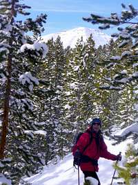 Rob and Gilbert
 Anne
Anne Coffin
 Mike
Mike MOCKBA
 Rob
Rob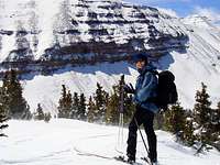 Me
Me