The Route Up
The forecast was for a rainy start to the day followed by brightening conditions in the afternoon. There was rain overnight, but the skies were largely blue in the morning.
I was headed over to Langdale to meet Bill - a work friend of mine - and some of his mates for a hike. I was a little early, so went for a wander taking some photos. As it turned out whilst a few people were there early, Bill was late. So much for him assuring me there would be no faffing about!
![The Langdale Pikes]() The Langdale Pikes
The Langdale Pikes
Once everyone was ready we started off on the climb up Stickle Ghyll. The newly engineered path was great. That was up until the river crossing, where one of the stepping stones was under two inches of fast flowing water! Not a good idea.
![Stickle Ghyll]() Stickle Ghyll
Stickle Ghyll
After passing up through a small crag we quickly followed the old path up to Stickle Tarn. The views opened up to one of the most spectacular views in the Lake District - Stickle Tarn and its local cirque.
![Harrison Stickle]() Harrison Stickle
Harrison Stickle
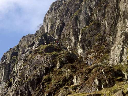
Bill and I wandered a while discussing possibilities. We decided to reccomend Jack's Rake. Bill wanted to do it - and I thought our group would be up for it. The photo above of Pavey Ark shows the main cliff, with Jack's Rake running diagonally from the Top Left to Bottom Right. The photo below shows the view up on the approach.
![The Bottom of Jack s Rake]() Jack's Rake
Jack's RakeJack's Rake
We headed to the bottom of the Rake, and to my surprise no one said "don't be ridiculous". Guess I underestimated the group - we headed up the Rake. The photo below showin Ambrose smiling up at me whilst everyone else focuses on the rocks under them.
![Starting on Jack s Rake]() Jack's Rake...
Jack's Rake...
I held back to get some shots back up the rake. At one point there was a choice between an easier but more exposed ridge most of us used, and a harder, wetter route. Bill chose the harder one. I avoided this - I don't mind the additional exposure!
![Looking up Jack s Rake]() Looking up Jack's Rake
Looking up Jack's Rake![Bill chooses the harder route]() Bill chooses the harder route
Bill chooses the harder route
Looking back down the Rake later on you can see a single tree strangely growing out of the mountainside.
![The Tree on Jack s Rake]() The Tree on Jack's Rake
The Tree on Jack's Rake
After this I took the role of Mountain Goat and led the route upwards. These are the stages where you can easily take the wrong route and I wanted to make sure we went the correct way. This pretty much meant I went the wrong way and told the others not to follow me!
As you can see from the final picture below, Bill was by this point enjoying himself quite badly. I wanted to get him to pose falling off the edge but this odd photo was the best I could manage!
![Bill acts the fool]() Bill acts the fool...
Bill acts the fool...The Rest of the Walk
There was a prolonged rest at the top whilst the party regrouped. I was pleased that no one was cursing my name or threatening to throw me off the cliff for taking them up that route!
I took the opportunity to get a few photos across the plateau from Pavey Ark.
![Pavey Ark Summit]() The view across Pavey Ark's summit...
The view across Pavey Ark's summit...
After some contemplentation we decided to head across to Harrison Stickle. On route we looked back to see the sheer cliff we had come up. A few shocked gasps were noted on realising where we had been.
![Pavey Ark Cliff]() Pavey Ark Cliff
Pavey Ark Cliff
We reached the summit of Harrison Stickle where it was pretty cold. A few pictures were taken and someone (I can't remember who but thanks!) got this picture of Bill and I.
![Bill and I on Harrison Stickle]() Bill and I
Bill and I
We decided to continue over to Pike o' Stickle. Bow Fell looked tempting in behind, but I knew it would take too long. The Pike can be seen at the far side of this photo.
![Pike o Stickle]() Pike o' Stickle
Pike o' Stickle
This next photo shows the view east from the Pike over Loft Crag - with Windermere in the background.
![Loft Crag]() Loft Crag
Loft Crag
After this we headed down towards Stake Pass. The route down was quite boggy - I felt guilty as it was worse than I expected. At one point whilst I led the group round a huge bog, Bill decided to run across it. He got a bit muddy but it could have been worse - I've been waist deep in that bog previously.
We had a chat at the pass and the consensus was to head over to Rossett Pass - we had the time. The route was boggy, but we made it. Bill was tempted to have a dip in Angle Tarn but decided against it...
Descending into Mickleden I got this final photo looking down the valley. The glacial shape can be clearly seen. This is the limit of my geological knowledge - however Bill was (and had been) busy pointing out various geological sights.
![Mickleden]() Mickleden Valley
Mickleden Valley
We wandered back in the lessening light. It was dusk when we got back to the New Dungeon Ghyll and the pub. We sat down for a quick drink - too late realising part of the group was in the other pub on the site.
It was dark by the time we left, followed by a bath, a pub and a good meal in Ambleside. There were a few tired limbs by that point! At 10 PM the others went on to another pub whilst I went to tuck myself up in bed. My alarm was set for 5:30 and a date with the Southern Uplands in Scotland, but that's another (very boggy) story...
Comments
No comments posted yet.