The Question
It all started with a passing comment as Rkymtn asked “If you have any extra time off this year would you be interested in putting together a trip to climb Orizaba?” Well it didn’t take long for this question to settle and grow from a possibility to a reality. After my trip to Bolivia earlier this year I hadn’t thought about another mountain trip so soon. Thanks to a very understanding and supportive spouse the trip was a reality. Now we just needed some climbers…
This problem didn’t take long at all to resolve. Besides the network of climbers from SP that we had met over the years Rkymtn and I knew of a few non-SPers that might be interested. Soon we had four others joining us on this adventure: ChicagoTransplant, Kiefer Thomas and our non-SP representatives Barry and Rush.
Arrangements were made for a driver and van while we were in Mexico. The amount of equipment needed on a climbing trip for each climber makes it harder to travel around in a taxi or minibus with six of us.
Exploration & Acclimatization
Mexico City
The team needed to fly different airlines due to costs and frequent flyer issues so we decided to meet in Mexico City. We learned a lesson soon after we landed in that Mexico City now has two terminals. As luck would have it five of us landed at Terminal 1 so we loaded the gear into the van and headed to Terminal 2 to pick up our stray. Since we weren’t there soon after his landing he went to Terminal 1 to find us. Thankfully an airport page allowed us to meet up without too much wasted time. The food court in Terminal 1 is on the second level which makes for a great place to wait and people watch. The numerous currency exchanges and ATMs on the main level can be used to convert some money into pesos easily enough. Using ATMs is the easiest way to go around Mexico as even the smaller villages are getting them installed. Plan ahead and have cash in case the ATM is not on your network thus stranding you without cash.
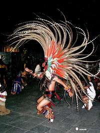
![Moon Dance]() Dance for a full moon.
Dance for a full moon.
We spent the night in the Central Historico district at the Hotel Fleming. The hotel is a two blocks south of the Alameda Central Park and seven blocks west of the Zocolo and the Temple Mayor, the heart of Mexico City. It was well worth the walk to visit the square for dinner as we had the added benefit of a Mayan dance next to the Temple Mayor to celebrate the coming full moon. Drums, chanting, rattles and elaborate feathered headdresses all included.
We departed for Puebla after an enjoyable breakfast next to the Alameda Central at a 50+ year old diner. The key to enjoying Puebla is location. Most of the historical attractions, museums and better restaurants are located in the blocks around the main square. Our hotel is a block away from the cathedral next to the zocolo. We spent the remainder of the day exploring Puebla, finding cultural dances and a Dia de los Muertos exhibit all made out of chocolate. According to Wikipedia:
![Day of the Dead]() Chocolate anyone?
Chocolate anyone?
If you have additional time tours of the local fortress, many quality museums, ceramic factories and churches should all be considered. If you have the time the Museo Amparo should not be missed.
La Malinche
Our third day of the trip was a climb of La Malinche (14,640 feet), north of Puebla, to continue our acclimation. The drive time from our hotel to the trailhead was just under two hours. Getting this far on public transportation would be difficult and take longer to arrive at your destination. I suggest hiring a driver for the day if possible to reduce the logistic issues.
![Final Ridge to Summit]() Final Ridge
Final Ridge
The hike up La Malinche is similar to hiking a Colorado 14er. The first three mile of the trail are actually a switch backed paved road which ends at a radio tower took about an hour. The tower was recently built on some older foundations as mentioned in Secor’s book. From the road the trail is straight uphill to treeline on a well defined, but often eroded, trail through the pine forest. As you clear the forest the first views of summit will hopefully be visible. Consider going up the right side of the mountain to the ridgeline then to the summit. This trail is steep but in good solid condition. If you go up the center to the ridge you will be hiking up in sand and scree which will cause you to slide down for every step you take up. Once on the ridge at the base of the summit the trail is ridgeline or talus all the way to the summit with a few Class III/IV moves to spice things up. We met a friendly local dog near the top who joined us and then guided us back to the trailhead.
| La Malinche |
Latitude |
Longitude |
Elevation (ft) |
| La Malinche |
19.279222 |
-98.042611 |
13,953 |
| Summit |
19.231 |
-98.032 |
14,617 |
Orizaba
Tlachichuca
The following day we traveled to Tlachichuca, our next step on the way to Orizaba. We stayed at the Limon’s hostel. The family has ten rooms, hot showers, and a dining/common room area just a few blocks from the main square. They provide meals and transportation up the Piedra Grande hut. If you are interested in a guide this can also be arranged. Maribel, who speaks English, coordinates the operation very effectively. You truly feel like you are a home with the friendly people and the home cooked meals. They realized we were on holiday and were very helpful in making sure we didn’t have any worries.
![Cemetery]() Cemetery
Cemetery
The town of Tlachichuca isn’t very large. We had an excellent lunch of tortas and soda across from the church on the plaza. The six of us filled the tiny restaurant. Afterwards we went up the street towards Orizaba and explored the cemetery on the edge of town. The cemetery was full of dry and dying flowers from the previous week’s day of the dead celebration. Otherwise there isn’t much to do or see in town. We spent the remainder of the day resting and organizing gear for our climb.
To cover the two days we’d be at the hut we took 4 20 liter bottles of water with us to eliminate the need to boil or treat the water while on the mountain. This is another item Maribel can sell you, or for 50-60 pesos a bottle, they can be picked up in one of the stores in town.
To Piedra Grande hut
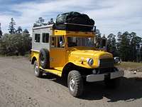
![Standard Transport]() Standard Transport
Standard Transport
We loaded gear and climbers into an old yellow Dodge Power truck and began the long 2 hours of dusty road to the hut. The road winds through farmland and open pine forest until just below the hut at 14,000 feet. The Piedra Grande hut is a rectangular stone building with a central division that supports three wooden floors as sleeping platforms along one wall. The remainder of the space is open with two small tables for cooking. Overall the hut is serviceable and in good condition. Calling it spotless is a stretch but the climbers and the two local outfitter families seem to keep the hut picked up and the trash contained.
After claiming our section of the platforms and setting up the kitchen most of us decided to hike up the valley to scout the route for our summit attempt that night.
![Trip Objective]() Our Goal
Our Goal
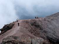
Scouting the Route
The trail up the valley starts out nicely on the concrete cover of old aqueducts. Once this path ends there are several trails that continue up the valley. In daylight it is easy to pick up a direct trail to the next section. At night with an alpine start the trail is harder to follow making the scouting worth the effort. This isn’t a big concern since all the trails end in the upper valley.
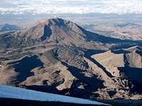
![Sierra Nevada and an Old Glacier Track]() Sierra Negra
Sierra Negra
The upper valley starts about 15,000 feet and is the first place you can easily set up a high camp. Water in this location is minimal at best so plan to haul enough water with you. All the trails merge into one trail that follows the left side wall of the valley. The first major break in the wall is at 15,200 and is the entry point into the labyrinth of bedrock and boulders from the recent glacial retreat that must be navigated to reach the glacier. In past trips I would consider this the crux of the climb as a lot of energy can be used trying to find a direct path through the numerous dead end chutes. The snow levels this time allowed for easier passage to the glacier edge. The best option was to keep the ridge of bedrock on climber’s right while proceeding directly up the snow chutes. This allowed for a pretty direct path to the small moraines and camping area at the foot of the glacier around 16,200 feet.
After scouting and taking some GPS waypoints for good measure we returned to the hut for dinner and an early bedtime. While we were gone another small team, lead by Eric Remza, arrived to share the hut. Their objective was to climb to the 15,200 foot level the next day to set up a high camp before proceeding to the summit. A solo climber from Hawaii was using the hut for cooking though he was sleeping in a bivy sack outside. As we prepared for bed two British climbers returned to the hut after a successful camp and climb. They even circled the entire crater around the summit. A brief chat discovered it was SP member parky and his climbing partner.
The Climb
The alarm went off and we were soon up getting ready and excited about the summit. I doubt anyone got more than a few minutes of sleep due to the excitement about the climb. What is important is everyone rested for 5-6 hours allowing the body to refresh before the climb. After an hour we were ready to head out under a full moon that made headlamps unnecessary. All the hours of training and trip planning were now being put on the line. Would we summit? Would everyone stay strong? Did I train enough? Only time would tell so the best that could be done was to put one foot in front of the other and head uphill.
Finding the entrance to the labyrinth by moonlight was easy. The GPS was a comfortable backup that wasn’t needed. The winds started to pick up and were noticeably cold as they rushed down the mountain from the glowing white fields of snow and ice above us. Once we had the crampons on and axe in hand we were truly on the way to a beautiful climb. Up until this point the dirt and rock path had failed to excite me as I have hiked countless miles of similar trails over the years. Once on the snow and ice I truly enjoy an alpine climb and this one was even better with a full moon and cloudless sky.
The climb up the actual glacier was fairly simple. The glacier conditions were more like a snowfield than a glacier. No evidence of crevasses or any other problems were seen. The slope was steepest to the left so we gravitated to the right shoulder of the summit. As we switch backed our way up the glacier we made slow progress due to the cold winds that numbed the face, chilled the fingers and at time took the breath away. I found myself shortening the right leg and then using the left direction to warm up before turning right again. A flag about half way up marked well kicked steps that followed the right side of the glacier. Why work harder than you have to at 17,000 feet? We gladly used the staircase in front of us which soon brought us to the northwest side of the crater rim just after sunrise. The crater is huge! Lined with jagged rocks and venting sulfur steam it made me realize while the glacier might be dying the mountain was still alive. We took photos of each other and had a snack break before continuing higher along a beautiful snow ridge to the summit crosses.
![Hermita]() Hermita
Hermita
Being we were so high the views were amazing even with all the smog and clouds. We could see the other mountains around central Mexico, especially neighboring Sierra Negra. Popo was busy smoking away thus ensuring climbers will still be banned from his slopes. Clouds were forming on the eastern side of the mountain far below us while the central valley was hazy and dark still enshrouded in the predawn cold by the mountain’s sunrise shadow. The cold and wind relaxed for several moments allowing cold fingers to coax cold cameras to take a few pictures before our moments of true clarity of the moment needed put away and the focus turned to our decent and safe return to the hut.
With the wind at our back the trip down the glacier was easier than the trip up. Once the staircase ended we still had plenty of the glacier left to descend. The ice and snow was hard with the consistency of Styrofoam that squeaked with each step of our crampons. The newly dawned day had yet to warm the glacier so glissading was not an option to speed our return to the labyrinth. Once at the glacier edge we repacked our gear and headed into the labyrinth following the track we had left just hours earlier.
| Orizaba |
Latitude |
Longitude |
Elevation (ft) |
| Piedra Grande |
19.057972 |
-97.269944 |
13,953 |
| High Valley |
19.053111 |
-97.270417 |
14,617 |
| Labyrinth |
19.047667 |
-97.270306 |
15,400 |
| Crater Rim |
19.031583 |
-97.269722 |
18,325 |
We did not rope up on this climb thus saving the weight of a harness, rope and hardware. There were no signs of crevasses and with the snow covered glacier if you did fall you shouldn’t slide far before arresting. Of course this is a call each climber will have to make based on the conditions and their experience level. Our judgment call was made after discussions based on condition reports of recent ascents.
We returned to find Eric’s group just about to start their climb to high camp. The packs looked heavy! Our first thought was food so water was soon a boil and a hearty lunch ready. Another favorite part of climbing is the post climb euphoria and discussion of what one saw and felt during the climb. Even though we climbed as a team there are many elements that are distinctively an individual experience from our motivation why we climb to how to achieve the objective at hand. We applied, like filters on a camera, our own perspective to the trip which allowed us to experience several climbs in the retelling over food and drink while the sense of our recent success began to sink in.
By early afternoon a truckload of climbers arrived disgorging another pile of equipment, bodies and food into the hut. It was SP Member Kurt Wedberg of SMI and his clients recently off of a successful Ixta climb. After they were settled in the hut, the global tradition among travelers and climbers of storytelling and information-sharing on peoples and places of the world began. Several more climbers arrived during the afternoon.
Our pickup the next day was set for noon in case we had needed another day to attempt the summit so we relaxed around the hut for the rest of the day. Kurt’s team was attempting their climb that night so dinner and bed came soon after sunset. Or so we thought. An hour after drifting to sleep Joaquin was tapping me on the shoulder asking if we wanted to go back to Tlachichuca. Behind him were eight Germans who were eyeing our sleeping ledges. Once what I was seeing registered it was an easy decision to pack up and head down the mountain by moonlight.
Tlachichuca Again
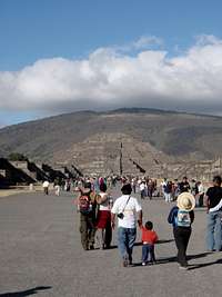
![Pyramid of the Moon]() Pyramid of the Moon
Pyramid of the Moon
We truly had a rest day ahead of us since we returned late the night before. The day went quickly as everyone did as much, or as little, as they wanted around town or even climbing the local hill, Hermita (9,520 feet), just outside of town. The views of Orizaba from Hermita make it worth the hike. It would also be a worthy acclimation hike prior to heading to the hut for anyone arriving quickly to Tlachichuca from a lower altitude.
| Hermita |
Latitude |
Longitude |
Elevation (ft) |
| Trailhead |
19.124444 |
-97.269722 |
8,753 |
| Summit |
19.140361 |
-97.422361 |
9,520 |
Teotihuacán
On Saturday we said our goodbyes the Limon family. They truly opened their home to us during our much to brief visit. The conversation, home cooked meals and their genuine warmth were immeasurable components of our trip. With Jesus at the wheel we left Tlachichuca and headed west to the Teotihuacán pyramids which are located north of Mexico City.
[img:468102:alignright:small:Pyramid of the Moon]
The Teotihuacán pyramids are amazing archaeological ruins. The city was occupied and expanded between 200 AD and 750 AD before it fell into disuse. The exact cause for its dissolution is unknown, as it often is for cultures without a written record, though a primary theory is one of environmental degradation. This degradation, when coupled with several years of drought and crop failures, caused a disbelief in the priests and gods; so in order to survive the people migrated to other regions of Mexico. The ruins are so impressive that the Aztecs 700 years later deemed the city as the birthplace of their gods. The major attractions are the Temples of the Sun and the Moon which are positioned along a 2 kilometer road called the Avenue of the Dead. Both temples are at least partially climbable up steep irregular steps. There are plenty of interpretative signs in English which allow a visitor to understand what they are seeing. The museum, located half way down the avenue, is top quality with excellent artifacts and timelines that fully explain the city, in both Spanish and English. If you have extra time when in central Mexico a visit to the pyramids of Teotihuacán is a great day trip.
The End
Once back in Mexico City we had time for a final celebratory dinner and by luck a rock and roll concert in the Alameda Central Park before the team members headed off either to return to Colorado or stay longer in Mexico. We had packed a lot into the seven full days we visited Mexico; it a successful trip in all regards.Appendix
Mexico City
Hotel Fleming (www.hotelfleming.com.mx)
Casa de las Sirenas – Top end in all regards. Overlooks the Temple Mayor
Café de Tacuba – Traditional cusine
Café Trevi – Breakfast place along Alameda Central Park
Puebla
Hotel Puebla Plaza (www.hotelpueblaplaza.com.mx)
Restaurant Royalty – Excellent food; located on the zocalo.
Restaurant Sacristia – Traditional cusine
Tlachichuca
Limon’s (cancholashouse@yahoo.com.mx) 19.114083, -97.421333
La Torta Vaquera
Tortas Itzel
Teotihuacán
Mi Mexico Lindo – Good food but certainly touristy.
Miscellaneous
Exchange rate 1USD~12.8 pesos
GPS used: Garmin Etrex Vista Cx
Guidebooks used: Mexico’s Volcanoes: a Climbing Guide by R.J. Secor and Lonely Planet’s Mexico (11th ed.)
Kiefer's Trip Report


Comments
Post a Comment