
|
|
Mountain/Rock |
|---|---|
|
|
46.99010°N / 11.81010°E |
|
|
Trad Climbing |
|
|
11197 ft / 3413 m |
|
|
What's new
Overview
If you look at the Zillertal Alps/Alpi Aurine (South-Tyrol/Alto Adige), it could be that you don’t consider Turnerkamp (or Cima di Campo, as the Italian call it) as you first option.
Hochfeiler/Gran Pilastro, Grosser Moeseler/Mesule or Schwarzenstein/Sasso Nero are famous in the valley and many climbers every year reach those summits.
Hochfeiler/Gran Pilastro, Grosser Moeseler/Mesule or Schwarzenstein/Sasso Nero are famous in the valley and many climbers every year reach those summits.
Well, it is a pity if you don’t pay attention to this wonderful and very elegant mountain.
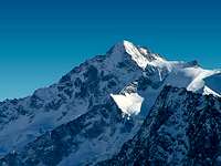
![Oestlicher Nevesferner...]() Turnerkamp/Cima di Campo from SW
Turnerkamp/Cima di Campo from SW
Turnerkamp is a complete mountain: rocks and ice represent the environment that characterizes the ascent and you can climb by different routes (difficulties range between II to V- depending on the choosen route). Turnerkamp is located on the boundary between Italy and Austria along the Northern Zillertal chain (see the panoramic view attached below). The hight of the chain is decreasing from West (Hochfeiler, with 3510 meters, is the highest mountain of Zillertal Alps/Alpi Aurine) to East and it is characterized by a basically homogeneous geological structure. Close to Grosser Moeseler/Mesule (West) and Schwarzenstein/Sasso Nero (East) Turnerkamp appears as a pyramid of rocks protected by four glaciers: a) Hornkees and Waxeckkees by the Austrian side, b) Oestlicher Nevesferner (Ghiacciaio Orientale di Neves) and Trattenbachkees (Vedretta di Dentro) by the Italian side.
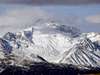
![Oestlicher Nevesferner...]() Oestlicher Nevesferner
Oestlicher Nevesferner
 Turnerkamp/Cima di Campo from SW
Turnerkamp is a complete mountain: rocks and ice represent the environment that characterizes the ascent and you can climb by different routes (difficulties range between II to V- depending on the choosen route). Turnerkamp is located on the boundary between Italy and Austria along the Northern Zillertal chain (see the panoramic view attached below). The hight of the chain is decreasing from West (Hochfeiler, with 3510 meters, is the highest mountain of Zillertal Alps/Alpi Aurine) to East and it is characterized by a basically homogeneous geological structure. Close to Grosser Moeseler/Mesule (West) and Schwarzenstein/Sasso Nero (East) Turnerkamp appears as a pyramid of rocks protected by four glaciers: a) Hornkees and Waxeckkees by the Austrian side, b) Oestlicher Nevesferner (Ghiacciaio Orientale di Neves) and Trattenbachkees (Vedretta di Dentro) by the Italian side.
 Oestlicher Nevesferner
 The date and the climbers of the first ascent are enough uncertain. Some writers report 1865 (J. Kirchler from Luttach/Lutago-Ahrntal), others 1872 (Hudson, Taylor and Pendleburg from England climbed with two local guide Spechtenhauser and Samer, the SW-face). The Normal route was climbed in 1874 (T. Harpprecht, Seyerlen and Dangl).
![Impressive north face of...]() North-face
North-face
 North-face
Getting There
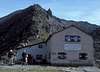
The ascent is possible both from Austrian and Italian side. The start point from Austria is the Berliner Hutte (2040 meters) and from Italy the Chemnitzer Hutte/Rifugio Porro (2419 meters). Rifugio Porro, located at the Nevesjoch (Passo di Neves) is the most logical and confortable start point. The hut is only 1:45 h from the artificial Neves lake (about 1850 meters). Paying few Euro for about 3 km of the private road coming from the village Lappago, Valle di Molini (Lappach) you arrive to the reservoir lake where you have to park the car and start to hike.
![The Neves reservoir from the...]() The Neves reservoir
The Neves reservoir
 The Neves reservoir
 The most important Italian villages in the area are located in Val Pusteria (Brunico/Bruneck) and Valle di Tures (Campo Tures/Sand in Taufers). From Highway A22 (exit Bressanone-Fortezza/Brixen-Franzenfeste), take the road (SS 49) towards Val Pusteria-Brunico/Bruneck or, arriving from San Candido/Innichen, follow the SS 49 to Brunico/Bruneck. Follow the indication to Valle Aurina/Ahrntal, continuing up to Molini di Tures/Muhlen, turn left and after 20 about kilometers, passed the village of Lappago/Lappach you arrive at the Neves reservoir.
Route overview
Routes overview according to Italian guidebook "Alpi Aurine", CAI-TCI, Milano 2002:
- SE-flank, normal route from Nevesjoch / Giovanni Porro hut, PD-/PD, UIAA I-II, (see more detailed route description);
- S ridge, D with passages UIAA III, IV e V- (see more detailed route description);
- SW-flank "Engländerrinne/Canale degli Inglesi", PD-/PD+, UIAA II+, 4:15-5:00 h from Nevesjoch / Giovanni Porro hut (Mathias Zhering reports 7:00 h from Berliner hut);
- E ridge, AD, UIAA II, III and V passage (the last one can be avoided), 3:45-4:15 h from Trattenjoch pass (but 4 h approach to there from Berliner hut and not much shorter from Nevesjoch / Porro hut). First climbers A. Wagner, E. Wagner, with guide H. Hoerhager 1891;
- N face, D-/D, UIAA IV, IV+, height of the face 350 m, starting point Berliner hut. 3:45-4:15 h from the attack of the wall. First climbers F. Drasch, J. Jurek, 1886;
- NW ridge, AD-, UIAA III, III+, from Forca del Dosso/Rossruggscharte 3235 meters 1:40-1:45 h. First climbers S. Frankause, J.Grill-Kederbacher Junior,w. Kendrick 1892; not that nice because some parts have to be climbed in the crumbly left face;
- NW face, AD/AD+, UIAA III, IV-. Height of the face 350 m, starting point Berliner hut. 3:00-4:00 h from the attack of the wall.
![Turnerkamp from Schoenbichlerhorn]() Northern side
Northern side
![A friend of mine is climbing...]() S-ridge
S-ridge
 Northern side
 S-ridge
A special thanks to Mathias Zehring for the useful comments and integrations.
Red Tape
In summer season, you must pay only few euros (3,50 in August 2006) for the private road up to the dam of the Neves lake.
When To Climb
The best season is the summer (from June to September). The weather condition, however, and the difficulties of the routes can change quickly even in summer. High risk of rocks falling down from the Normal route.
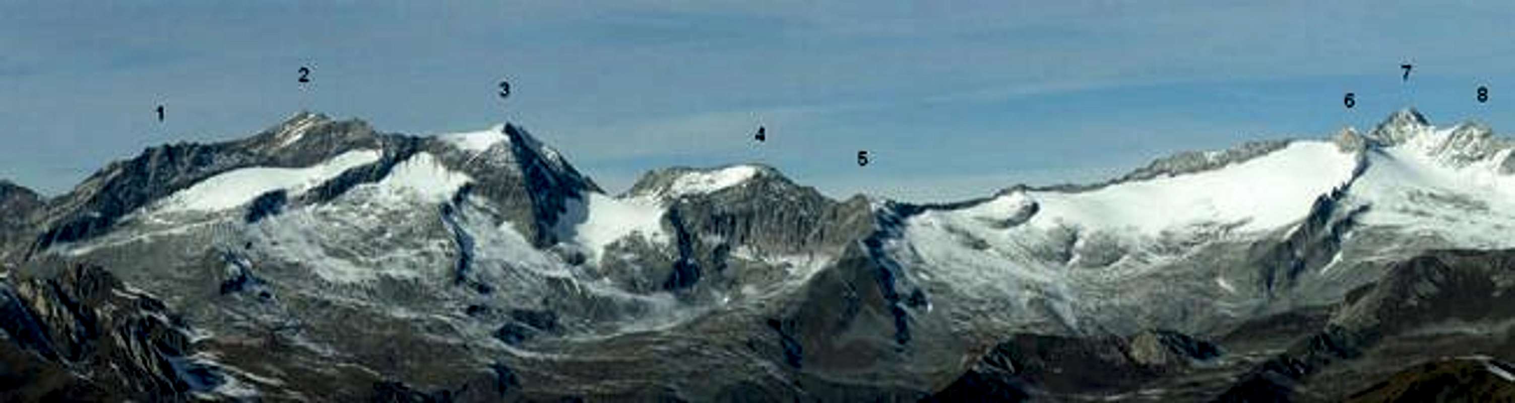
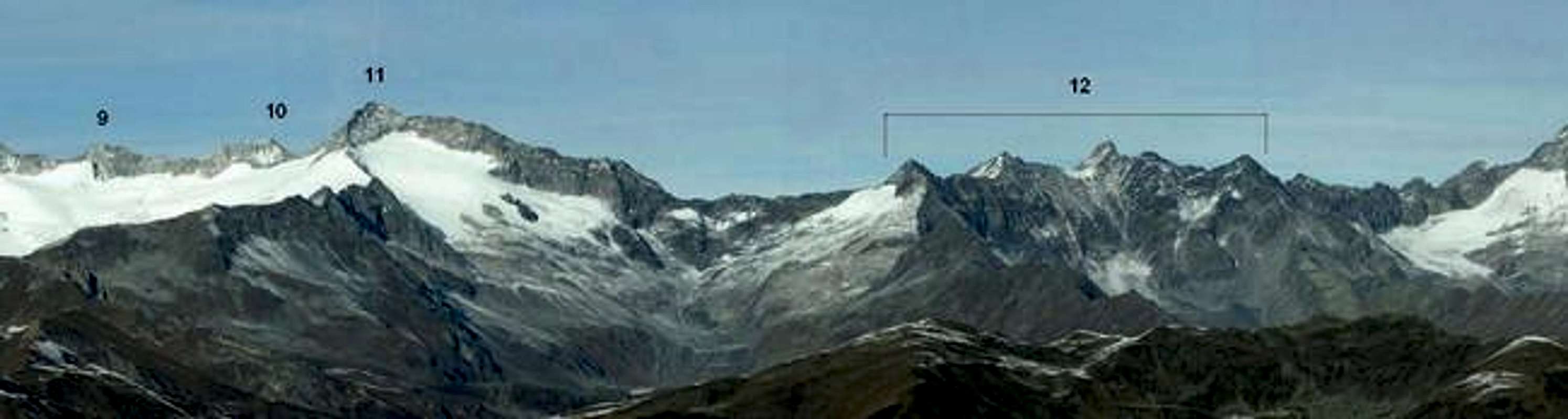
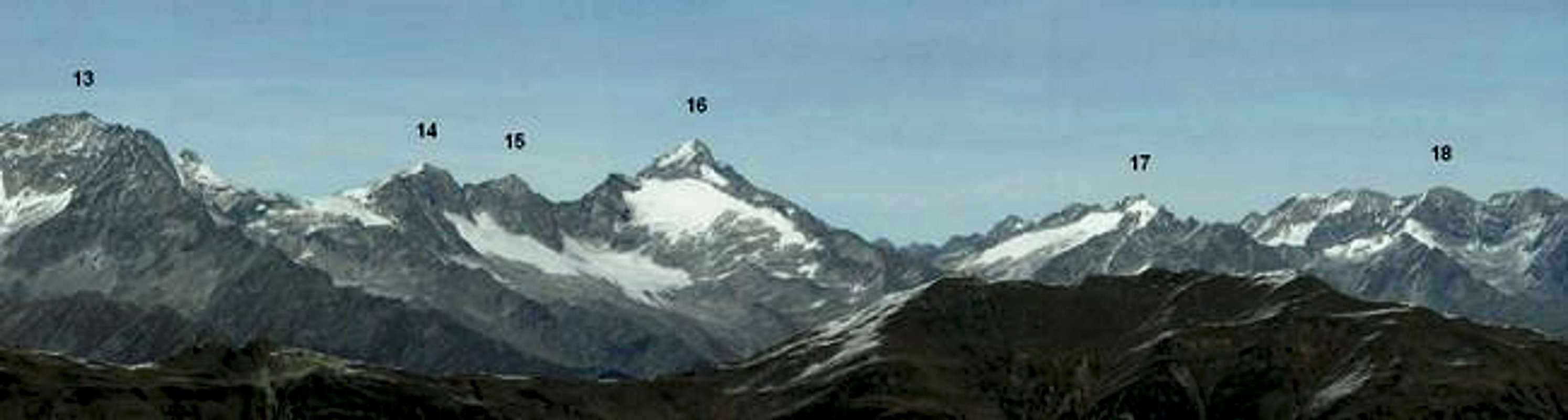
1=Punta Bianca Bassa/Niederer Weißzint; 2=Gran Pilastro/Hochfeiler; 3=Punta Bianca/Hoher Weißzint; 4=Dosso Largo/Breitnock; 5=Muttenock; 6=Möselekopf; 7=Gran Mesule/Großer Möseler; 8=Piccolo Mesule/Kleiner Möseler; 9=Möselenock; 10=Rossruggspitz; 11=Cima di Campo/Turnerkamp; 12=Cinque Corni di Ghega/Fünf Hornspitzen; 13=Sasso Nero/Schwarzenstein; 14=Westliche Floitenspitz; 15=Östliche Floitenspitz; 16= Monte Lovello/Großer Löffler; 17=Punta del Conio/Keilbachspitz; 18=Punta di Valle/Wollbachspitz
 |  |  |
Panoramic view
 |  |  |
Camping
Camping is not forbidden on the mountain but is at least discouraged by the refuges. Rifugio Porro, from Italian side, and Berliner Huette, in Austria, are confortable places for climbers directed towards the Turnerkamp.
The nearest camping area, in Italy, is located in Brunico / Bruneck (Val Pusteria)
 |
Mountain Conditions
Updated information are available directly by the refuge Rifugio Porro / Chemnitzer Huette, or on the net (Meteo Alto-Adige and Alpenverein Austria)
- F. Cammelli, W. Beikircher, "Guida dei Monti d'Italia - Alpi Aurine, Brennero-Gran Pilastro-Vetta d'Italia", Ed. CAI-Touring Club Italiano, Milano, 2002 (ISBN 88-365-2603-9);
- W. Pause, "100 scalate su ghiaccio e misto", Ed. Goerlich-Istituto Geograqfico de Agostini S.p.A., Novara, 1978;
- L.A. Fincato, M. Galli, "I monti della Valle Aurina", Ed. Industria Grafica Pusteria (1985);
- L.A. Fincato, "Monti Rifugi Paesi delle Valli Aurina e Pusteria", Ed. DIP-Druck, Brunico (2000)
and one in German:
- "Zillertaler Alpen", Bergverlag Rother, Munich (1983)
Books
Four books in Italian:- F. Cammelli, W. Beikircher, "Guida dei Monti d'Italia - Alpi Aurine, Brennero-Gran Pilastro-Vetta d'Italia", Ed. CAI-Touring Club Italiano, Milano, 2002 (ISBN 88-365-2603-9);
- W. Pause, "100 scalate su ghiaccio e misto", Ed. Goerlich-Istituto Geograqfico de Agostini S.p.A., Novara, 1978;
- L.A. Fincato, M. Galli, "I monti della Valle Aurina", Ed. Industria Grafica Pusteria (1985);
- L.A. Fincato, "Monti Rifugi Paesi delle Valli Aurina e Pusteria", Ed. DIP-Druck, Brunico (2000)
and one in German:
- "Zillertaler Alpen", Bergverlag Rother, Munich (1983)
External Links
- Austrian Map online
Online digital maps of Austria (OEK 50, OEK 200 and OEK 500) by the BEV (Bundesamt für Eich- und Vermessungswesen) - in German