
|
|
Mountain/Rock |
|---|---|
|
|
39.11819°N / 106.98127°W |
|
|
Pitkin |
|
|
Hiking |
|
|
Spring, Summer, Fall |
|
|
13020 ft / 3968 m |
|
|
Elk Mountain Range
Colorado's Elk Mountain Range has six fourteener’s and 4 centennial thirteeners. Indeed these mountains are some of Colorado’s most beautiful. However, beauty doesn’t necessarily translate into good climbing. The Elk Range has a reputation for loose and crumbling rock. Like all mountain ranges, some summits are more dangerous to reach than others; many peaks can be hiked, however good routefinding and climbing skills are of paramount importance for most of the difficult peaks. Furthermore, most of the centennial peaks require top physical conditioning. Only one of six fourteener’s has a walk-up route to the summit. In the Elks, the use of a rope can be more of a hindrance than a tool for safety. The potential for rock-fall is always nearby.
The combination of abundant snowfall and generally steep and narrow valleys, makes access to these mountains a serious obstacle during winter months. Many of the valley slopes are ribbed with dangerous avalanche paths, which limits winter mountaineering to only the most daring and adventurous souls.
If you choose to spend time hiking and climbing the Elks, expect a different experience every time out. The experiences here vary; mostly good, but occasionally bad. So play it safe and everything will work out fine.
UN13,020 B Overview & Route

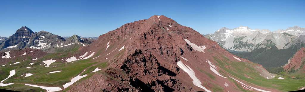
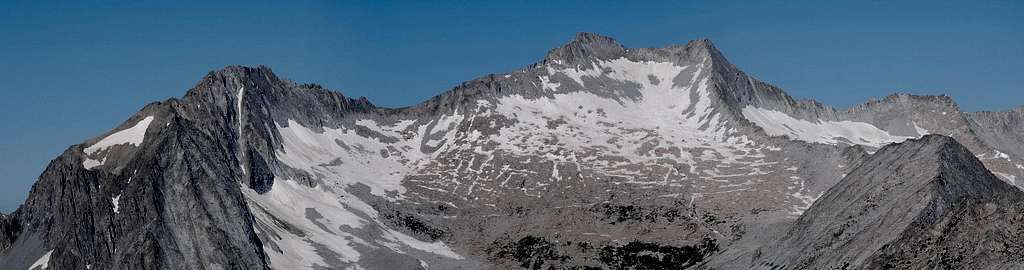
UN13,020 B resides in the spectacular Willow Lake Basin between Buckskin BM and “Willow Peak”/UN13,336. Along with Baldy Mountain and UN13,039 these mountains combine to form a long ridge of unforgettable beauty that eventually connects to the world famous Maroon Bells massif. You may have read my rave reviews in the past concerning Willow Lake Basin, but I’m here to rave again. The special Willow Lake area is a place that’s near and dear to my heart. It’s a place where idyllic alpine beauty presents itself in a way that’s difficult to explain. What makes it so special? One word, “color,” or I should say “exploding color.” It’s that simple, I’ve never been to another place that mimics the saturated colors of Emerald City in the Wizard of Oz. On a sunny day in dead summer Willow Lake Basin is alpine splendor on steroids.

UN13,020 B only requires good physical conditioning to reach its summit via its southeast slopes. There is no scrambling or climbing so it makes for a safe day for almost everyone. It is a class 2 hike up incredibly steep tundra to a summit with one of the better views I’ve seen. The highlight views include great perspectives of North Maroon, Pyramid, Buckskin BM, Snowmass and Capitol Peak. UN13,020 B makes for a worthy day drip from the Maroon Lake area. The approach to Willow Lake Basin via the Minnehaha Drainage is classic and the peak combines well with UN13,336. The ridge connecting it with Buckskin BM is too rough to consider however a descent of Buckskin’s south slopes directly to Willow Pass gets you back on track for the hike to UN13,020. There are two route possibilities that I’m aware of for climbing UN13,020 from the Willow Lake Basin, the southeast slopes or the north ridge. The easiest ascent starts about 12,240-ft on the trail that eventually ascends to the saddle between it and Willow Peak. The trail traverses the southeast slopes of UN13,020 B. Leave the trail where it starts to bend around north to the pass and ascend incredibly steep tundra up an initial shallow gully. Above the gully, locate easier ground on the grassy ridge crest and continue up another tundra covered slope. The last 75-ft requires easy class 2 hiking up a rocky gully to the summit area. The north ridge goes from the saddle between it and Willow Peak. I did not use this route but have read that it goes fairly well with possibly easy, loose class 2+.
 |  |  |  |
Map, Stats & Approach
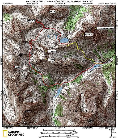
UN13,020 B via the Minnehaha drainage & Willow Lake Basin 9-12 miles & 4,500-ft Use the red route to get into Willow Basin. Most everyone should use the red route back to Maroon Lake as well but if you have some adventure in you carefully studdy this Yellow route and use it. It's 2,500-ft in less than a mile. It's incredibly steep but it goes and mostly on tundra. It's not as simple as just cruising the steep tundra. There are places where you will need to use good routefinding to avoid heinous obstacles like willows, dense aspen tree siblings, talus and steep dirt. It takes about 1.5 hours to hike from Willow Lake to Maroon Lake using this route. Go here for a detailed approach description to Willow Lake Basin.
Maroon Lake Trailhead & Red Tape
Approach the Maroon Bells from the Maroon Lake TH (9,590-ft.) From Aspen, locate a round-about a half mile north on Hwy 82 and drive west on Maroon Lake Road for 9.4 miles to the parking area. Starting June 14, Maroon Creek Road restrictions will start and visitors will be directed to RFTA bus service. Buses from Aspen Highlands arrive at Maroon Lake every 20 to 30 minutes. All day users will be required to ride the bus between 9 a.m. and 5 p.m. The bus fare is $6 per adult and $4 per senior and child. During these hours a shuttle can take you to the trailhead from Ruby Park in downtown Aspen. The shuttle ride is free. Call RFTA at 970-925-3445 or the White River National Forest at 970-925-3445 for schedules. Typically arriving before 6:00am will allow you to enter at no charge and avoid the shuttle. John adds regarding the summer shuttles to the trailhead "The shuttle bus for Maroon Lake Road is only mandatory from June 19 to September 3, including other weekends in September. Outside of this period, you are free to drive up yourself. The road closes between 8:30 am and 5:00 pm, however, the first shuttle bus does not leave until 8:55 am (Highland Ski Area Parking Lot) or 9:00 am (Rubey Park). For more information see the Roaring Fork Transit Authority Maroon Bells page or call 1-970-925-8484 for Rubey Park Bus Information." The road is closed at the T Lazy 7 Ranch in winter and adds 14 miles round trip to the climb. There are no fees required when the road is closed for winter. The Peak is in a Wilderness Area and Wilderness rules and regulations apply. There is a FREE required registration at the trailhead. See the Permit section below for details. Current information regarding the Wilderness area can be found on the official National Forest Service website. The NFS Ranger Station can also be reached by the following: Aspen Ranger District806 West HalamAspen, CO 81611 Phone: (970)925-3445Fax:(970)925-5277. Maps: Maroon Bells, White River National Forest USDA Forest Service White River National Forest P.O. Box 948 Glenwood Springs CO 81602
Personal Account/Trip Report
After the strenuous day on North Maroon, I needed a tundra hike to sooth the soul. I picked UN13,020, a peak that teams up with Buckskin BM and Willow Peak to form the northern rim of the long ridge of peaks that eventually connects to the Maroon Bells massif. I was excited to have stellar weather considering the area had 14 consecutive days of monsoonal moisture prior to my North Maroon trip. I was also excited to have the opportunity to visit one of Colorado’s most beautiful places for my third time, the incredible Willow Lake Basin. I started hiking with headlamp at 5:15 am and made the Crater Lake area at 6:10. A turn north on to the Buckskin Pass Trail netted a brilliant sunrise on the Maroon massif. I continued and made Willow Pass at 8:20 and descended into the Willow Lake area, and so my religious experience would begin. Words can not describe how beautiful this place is, its pure sensory overload. It’s like Mother Nature jacked up the color saturation level, to mimic the Emerald City look in the land of OZ. When it’s sunny, there’s so much bright color even my Nikon D-200 has trouble metering a correct exposure. You just have to go and see it for yourself. UN13,020 is easy to locate, so I traversed the upper basin to a single-track trail that ascends to a pass in between UN13,336 and my objective. Before the trail bends around and ascends to the pass I left it and began a steep tundra hike up a grassy, shallow gully. Above the gully, I found a lot easier ground to ascend on a grassy ridge crest that eventually turns into another grassy slope. After the slope the summit ridge appeared and with a minor class 2 rocky gully to negotiate, I stood on the summit at 9:45 with a view to die for. I had incredible weather, with zero cloud cover for as far as I could see. Usually I only haul a cheap small tripod, my camera and one lens for my climbs but I was thrilled to have lugged my big tripod and my additional 55-200mm for summit photos. I set up shop and took photos for an hour. The view from UN13,020 is one of the better ones I’ve seen. The highlight views include great perspectives of North Maroon, Pyramid, Buckskin BM, Snowmass and Capitol Peak. I descended the easy slope back down to the tundra ridden basin and spent another two hours exploring every nook and cranny I could. Many of these places seemed familiar from previous vists. There are many smaller lakes to explore including the very large and deep Willow Lake. I still have trouble understanding how so many people visit Maroon Lake and how so few of them ever make the hike to the Willow Lake area. For some beautiful reason, word hasn’t gotten out, and that’s ok by me. There’s a small grassy ridge that rises above Willow Lake and connects to Sievers Mountain. From there you can peer straight down 2,500-ft on a thousand tourists. If you count me among them, that makes a thousand and one of us. It’s interesting to think that every one of them and me feels great about what they are sensing and seeing. Knowing this makes me feel confident I’m the luckiest one of all.