Up to the Hub of Utopia – Climbing Tristan da Cunha's Queen Mary's Peak

Up to the Hub of Utopia – Climbing Tristan da Cunha's Queen Mary's Peak

Page Type Page Type: Trip Report
Location Lat/Lon: 
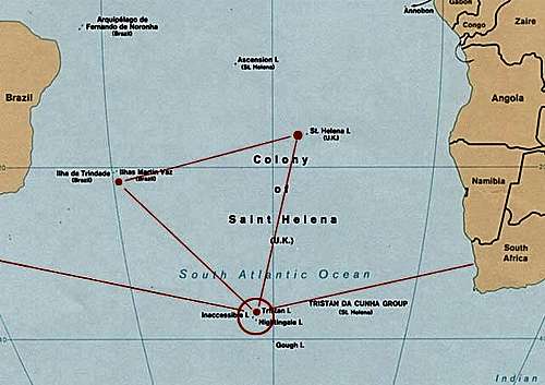
37.11158°S / 12.28847°W
Date Date Climbed/Hiked: Sep 15, 2009
Activities Activities: Hiking
Seasons Season: Spring

Utopia

In 1516 Thomas Morus published his “Utopia”, the design of an ideal community. Vulnerable as he sensed it to be, he placed it on an imaginary island. Ten years before, in May 1506, the Portuguese sailor Tristão d'Acunha had already discovered where this island could possibly lie: in the South Atlantic, farthest away from any other human settlement, over 2,400 km to the south of St Helena. He named the island after himself. But Tristan da Cunha was and remained uninhabited for three more centuries. Only in 1816 William Glass made his dream come true and founded a model society of his own there – three decades before Karl Marx invented communism. While the latter was dying silently around 1990, Tristan still enjoys a thriving health. A total of 264 inhabitants concentrate in the “settlement” of Edinburgh-of-the-Seven-Seas, nestled on the north west edge of 96 square kilometers of rugged terrain.
The remotest islandThe remotest island

Idea

As a mountaineer I feel attracted to “independent” countries and their highest points. The passion of my lifetime is climbing on each individual highest mountain in every European country – www.gipfel-und-grenzen.eu – including “independent” territories politically attached to European countries. So already a long time ago Tristan da Cunha and its Peak, the highest point of British-inhabited territory, caught my eye.
Tristan da Cunha - the PeakTristan da Cunha - the Peak

Disappointment

I came to Tristan first in February 2006 on board the RMS St Helena in the tow of the governor and about one hundred celebrities – scientists, environmentalists, ornithologists, philatelists and other weird characters with hobbies as strange as mine – on occasion of the 500th anniversary of Tristan's discovery. It was summer; naïvely I had believed this to be the optimal season for a climb on the Peak and got bitterly disappointed: Not only had a hundred co-visitors been dumped on the island and swamped it now absorbing all local capacities, but also had I not foreseen this was the time for festivities, receptions and speeches: no chance within the one week of stay to get hold of a local guide – legally required by Tristan's government if one wants to climb Queen Mary's Peak. In addition I painfully learned that mountaineers have to face another difficulty on the island: lingering veils of clouds and mist covering the cone of the circular volcano. Particularly in the summertime the warm air carries a lot of moisture from the north west, the predominant source for the weather on Tristan.

Waiting in vain for a clear day I eventually chose to get back to the vessel anchoring off Tristan, just to change clothes and take a shower, and suddenly found myself trapped: The weather-watchers had just decided to interrupt all traffic to and from Tristan for safety. Here I sat now on the RMS St Helena in all her luxury, like a prisoner of my own ambitions, an outcast, and finally had to sail away, back to Cape Town, with all the other evacuees. I had not even moved a single step uphill towards my goal. What a shame: There stood the Peak in full glory – the clouds had cleared in the last minute – while we steamed off. Tristan, bye-bye! All in vain.

Approaching Tristan6 a.m. on th bridge of the SA Agulhas: Tristan in sight

Plan

Did it really mean everything was lost? Had utopia vanished? By no means. After all I had learned a lot. I would need to come back again, better-prepared, in a different season, under different circumstances, to make my dream come true and turn the utopia of ever climbing the Peak into reality. I had no time to lose: I was now 65 years old, my energy lessened; on the other hand the Peak had to be climbed in one day – vertical 2,000 meters up and down – more time the rare and short weather windows would not allow. I would have to get up next time by all means.

What was "normal" on this mountain? Clouds and mist hanging down to 200 m altitude. Wind force and direction would decide whether the clouds covered the entire cone or possibly formed a ring at medium altitude through which to pierce and push one's way into the full sunshine above, or whether there would be no clouds at all. It definitely would require more than just one week on the island to exploit my slim chances.

I studied transportation facilities. There is neither an airport on Tristan, nor regular ship lines, not even a harbour to accommodate large tourist vessels, There are, however, the fishing vessel "Edinburgh" and the cargo ship "Baltic Trader", both offering a couple of berths – usually occupied by officials and medevacs seeking treatment in Cape Town; these enjoy priority. No chance of ever sneaking in an opening. And there was the South African research vessel "SA Agulhas" serving Gough every September/October: That was the way to go; it offered space for 80 passengers and allowed me to hop off at Tristan and to be collected on the return trip back to Cape Town three weeks later.

Preparation

So September 2009 me and my brother-in-law Robert boarded the “Agulhas” at the East Pier in Cape Town. Seven days on sea and two minutes in a helicopter – and we landed on the green in front of the school, Edinburgh-of-the-Seven-Seas, Tristan. We were on the beloved island again, now for good.

We lived in James Glass' guest house. James also was our prospective guide. Idle days went by, with clouds hanging deep as usual – no chance of setting off. We began to study ravines – "gulches" as they are called here, steep meadows and ridges; our views directed upwards, hoping this would lift the mist. In the meantime James consulted the Internet for weather forecasts, so we trusted his wisdom and expertise and waited ...

On the fifth day (of 26) on Tristan James gave us a hopeful warning: Next day could turn out unique – winds calm and from south west, meaning from Antarctic whereabouts and carrying only little moisture; this promised a clear day ahead. And so it was: When our alarm rang at 5:15 a.m. we glanced into a star-spangled sky.
Our guidesOur guides

Ascent

We assemble at James' house; with us is also Anton from South Africa and his guide Jerry Green. 6:30 a.m. sees five men and two sheep dogs march out of the settlement on the road leading to the potato patches, greeted by “cock-a-doodle-doos” and the “good-mornings” of fishermen setting off for work on the sea. At 7:00 a.m. we veer left onto a grazing meadow that soon develops into a steep slope accompanying Hottentot Gulch at its south west rim. Step by step we gingerly ascend – sheep have mercifully trampled the ground, so that it forms a giant staircase to our benefit. At the slope's upper end a hardly visible track leads us further up left, overgrown at places by thick branches of Phylica arborea, the only island tree. We balance alongside the perpendicular walls bordering the gulch – convenient for committing suicide, insurmountable for those liable to giddiness, character-building at least for us, even when assisted by fixed ropes. Then we traverse the gulch's bed and work our way further uphill even steeper, often taking the filmy ferns aside to lean on for dubious safety.

8:45 a.m. We gaspingly reach the edge at the horizon; suddenly the terrain changes to a flat, grassy ledge. This 690 m high plateau is rightly called "the Base". For on the stump of the 200,000 year-old volcano sits a flatter, younger cone now visible for the first time far in the distance to the south – right hand: the Peak.We rest for a while and leave half of our luggage behind.

From now on it's easier walking. We turn directly towards the summit. Merrily we make our way across meadows, by-passing shallow dips dotted with small colonies of Bog Fern, sheltered here from the often battering storms. They resemble little palm trees; their spores blow in the wind as we carefully step into the pits in-between. Not that merry may the encounter have been for a pair of Albatrosses that we disturb in their nest; the dogs are keen to hunt them, but Jerry's quick and loud shout calls them back and prevents a disaster.

We venture back to the right, across a couple of flat valleys, and follow now the rim of Hottentot Gulch as it gradually becomes steeper, up towards the summit area. Grassland alternates with lava scree, scinders and slippery sand. Fortunately, the melting snow from shady pockets along the path moisturizes the sand, so it won't glide under our boots, but offers a soft and less exhausting climb. Still Church Rock ahead on the horizon provides the illusion of the true summit like a fata morgana. We scramble through fields of flat icicles modelled by previous storms, and past emerald-green moss beds and ruby-red fowl berries that have sprouted between the reddish-brown cauliflowers of Andesite rock. Rich miniature gardens of their own.

By the time mid-day approaches the bright sunshine is being diluted by drifting mists below and flurries of creeping haze above – all just transient; they never obstruct our view. Eventually at 1 p.m. the upward curve flattens and we reach a group of rocks marking the deepest point of the circular crater rim. Opposite us rises the dome of Queen Mary's Peak, flanked by rocky castles on either side. Only the ice-covered crater lake separates the crater mouth from the summit.

Before chilling out we better thrust ahead, clock-wise around the crater. Only 25 minutes later there is no higher anywhere anymore: We stand on the icy summit, the hub of our little universe, and glance to where Inaccessible and Nightingale sail in the hazy dark-blue sea below. Happy seconds of shaking hands and congratulating each other; James and Jerry proudly pose with the Tristan flag, dozens of pictures are being shot.

Soon we are on the descent. We rest again for a short while at the crater mouth, feeding ourselves and the brave dogs. The rest is just tumbling downhill, were there not the painful cramps hitting my upper tighs alternately. I treat this with salt tablets and energy concentrates. There is not much time for looking back a last time; I have to hurry not to lose contact with my comrades. But the discomfort from my legs is made up by the comfort from my soul: I have finally made it – Queen Mary's Peak "under my belt."

Back at the Base, on the verge of tipping over, the real challenge still awaits us: We plunge into the deathly grandeur of the sheer cliffs of Hottentot Gulch below. Extreme care is demanded as we set our steps on the rope-secured path winding down hairpin by hairpin. Leaning to the fern covers from where the tiny mossy Devil's Fingers (Lycopodium) stand out offers no great help in case one of us slipped; the journey would be right into death.

Luckily this part is over soon, while we walk out onto the steep meadow that had caused us the first sweat this morning. Twelve hours have passed as we enjoy the glorious sunset casting its last shimmering rays towards the glowing cliffs towering Hottentot Gulch. My tired legs hurt; I am thirsty and worn out as we trudge into the settlement. But: We have made it! We all have been up! The real winner is Robert, at 69 ½ years the oldest foreigner ever on the summit.

All that remains are memories. Whenever in the future we need to lift our mood we will joyfully remember Tristan da Cunha and its friendly people. Whenever we need to overcome bleak situations we will proudly cling to the axis of our utopia. The world may rotate, but memories of the Peak will remain. We bow to you in gratitude, Queen Mary.


On the Base, the Peak aheadOn the Base, the Peak ahead
An Albatross protecting the PeakAn Albatross protecting the Peak
At the crater mouthAt the crater mouth

Near the summitNear the summit
On the summit. Inaccessible sailing in the hazeOn the summit. Inaccessible sailing in the haze
The final meters up to the summitThe final steps up to the summit

Presenting the Tristan flagPresenting the Tristan flag
Lonely walk in the craterLonely walk in the crater, Queen Mary's Peak in the background

A last view back on the PeakA last view back on the Peak

The hub of the world hidden mysteriously behind veils of cloudsTristan sunset: The hub of the world hidden mysteriously behind veils of clouds

Bye-bye TristanBye-bye Tristan. Twice in a lifetime is enough. I will never see you again ...


www.gipfel-und-grenzen.eu

Comments

No comments posted yet.


Parents 

Parents

Parents refers to a larger category under which an object falls. For example, theAconcagua mountain page has the 'Aconcagua Group' and the 'Seven Summits' asparents and is a parent itself to many routes, photos, and Trip Reports.

Queen Mary's PeakTrip Reports