|
|
Route |
|---|---|
|
|
40.67680°N / 111.144°W |
|
|
Cross country hike with minor scrambling |
|
|
Half a day |
|
|
Class 2 |
|
|
Approach
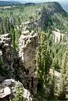
The Upper Setting Road takes of north off Highway 150 8.7 miles east of Kamas. The lower section of this gravel road is good for passenger cars, but the upper half of the road is suitable only to high clearence vehicles. There are many side tracks, but follow the main trail to its end.Route Description
From the trailhead, follow the old 4wd track west to a junction with another track heading north. This junction is just before a stream crossing to the west. Head west (left) across the small stream to another junction. The branch to the west (left) end shortly; take the branch to the north (right). This branch of the track climbs north and then southwest and will take you to beautiful Castle Lake.From the lake climb cross-country to the west to the ridge north of Castle Peak. From the ridge north of Castle Peak, notice the saddle to the NW. This is the saddle between Box Canyon and Yellow Pine Creek. Hike over to this saddle. From the saddle, head west along the ridge for a mile to the summit of Duke Mountain. The total round trip distance is about four miles.