
-
 4681 Hits
-
 71.06% Score
-
 1 Votes
|
|
Route |
|---|---|
|
|
46.72762°N / 10.40927°E |
|
|
Hiking, Skiing |
|
|
Spring, Summer, Fall, Winter |
|
|
Half a day |
|
|
Hike |
|
|
Overview
 Val Sesvenna Val Sesvenna |
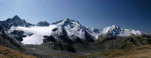
The ascent of Fuorcla Sesvenna from S-Charl through Val Sesvenna is one of the popular hikes you can do in the area. The first part - until you reach Alp Sesvenna - runs along a dirt road. At the Alp several trails branch out, on leading directly through the valley to the Saddle. In Spring, water is everywhere in the shallower parts of the valley and you might be forced to wade through muddy lakes. For most of the part the route is flat but there are several terrain steps across which steep rocky paths lead.
From the lake at the base of Vedretta Sesvenna, the Sesvenna Glacier, a curving trail leads you to the saddle. Schadler is located right to the north-west of the saddle and can be reached in a pathless scramble. The Schadler south slopes are shallow and there are many possible routes to the summit.
Getting There
 Piz Cortschen from the trailhead
See the Getting There section on the main page for the itinerary to S-Charl. The parking lot is north of the village, the trail through Val Sesvenna starts at its eastern end.
Route Description
 Piz Cortschen (3046m), Piz d'Immez (3026m), Piz Cornet (2971m)
- Start altitude: 1800m
- Summit altitude: 2948m
- Prevailing exposure: S
- Type: Hike
- Protection: None
From the village centre of S-Charl turn eastward and follow the signs to Alp Sesvenna. You follow a dirt road along the right bank of the Sesvenna Creek. After a while you cross the creek and a first steep section leads you to Alp Sesvenna. The road is rotten in that section and horrible to climb on foot.
The road ends at the alp. Cross the fence and head onwards, always following the direction of Sesvenna Creek. You cross a meadow on which there are house-size blocks. Bass the blocks and you'll reach an intersection. If you stay on the trail you'll soon return to Sesvenna creek at the base of one of the big steps in the terrain. Climb ste step to the left side of the creek and soon you'll reach the beautiful central part of Val Sesvenna.
 Piz Madlein Piz Madlein |  Piz Cornet Piz Cornet |  Piz Christanas, Piz Rims Piz Christanas, Piz Rims |
Here the valley is flat for a length of several kilometres. The creek winds its way all across the broad valley base. In some places the valley has turned into a swamp-like fen. Follow the tracks to the right side which for most part run on solid ground. From the left the huge ground morraine of a former glacier comes down from Piz Plazer after which you reach the second step in the terrain.
 Meandering Sesvenna Creek
Again, a narrow path winds up this step and tops out on a small plateau on which you find a glacier lake, fed by Vedretta Sesvenna. Stay on the left bank of the lake and in a wide left curve the trail leads you Fuorcla Sesvenna.
 Muntpitschen (3162m), Piz Sesvenna (3204m), Piz Plazer (3104m)
In the saddle a sign points to Scharler (another name for Schadler), Piz Christanas and Piz Rims. Follow the tracks onto the Schadler south slopes from where a more or less traill-less scramble leads you to the top.