-
 2907 Hits
-
 75.81% Score
-
 6 Votes
|
|
Mountain/Rock |
|---|---|
|
|
61.0962°N / 149.564°W |
|
|
Hidden Peak is an infrequently visited high point that is situated a little less than a mile ESE of the more frequently visited O'Malley Peak, and directly above (to the NE) Hidden Lake. As the name implies it isn't very obvious from many locations, it is mostly hidden from view from where most people hike in the area, including the well traveled powerline trail.
Use the Glen Alps trailhead, a well signed starting point on Glen Alps Road on the southeast side of the town of Anchorage. Follow the trailhead to powerline trail, and follow that trail about 2 miles SE to a well marked turn that takes you to a good bridge across Campbell Creek. You can shave off this easy and farily level part of the hike (about 2.5 miles one way) by mountain biking from the parking lot to this bridge, and lock your bike at a rack on this bridge.
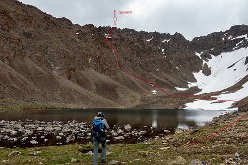
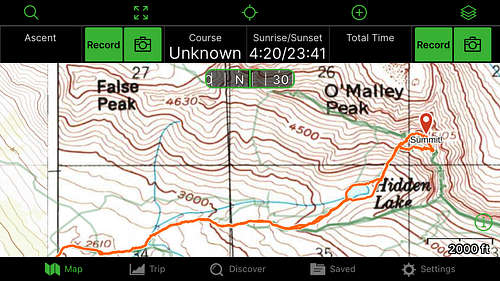
These two images show the direct route from Hidden Lake. It's also possible to get there from the south (using the trail that goes to the nearby peak "The Ramp") and the west (accessing this peak from the more popular O'Malley Peak).
No permits required, however there is a $5/day fee to park at the trailhead parking lot, which is necessary because there aren't alternative parking locations in the area. You'll be ticketed if you park out on the road, and often the lot becomes full on beautiful days. It can be necessary to start early to get a parking spot.
Snow free months are likely to be June, July, August.
Free camping is allowed in the backcountry for groups less than 12. Just make sure your vehicle is paid up for all the days you'll be there.
Add External Links text here.

