Overview
![Monte Altissimo di Nago (2079m)]() Monte Altissimo di Nago (2079m) seen from the trailhead. The route runs up the ridge to the left
Monte Altissimo di Nago (2079m) seen from the trailhead. The route runs up the ridge to the left
The main page of
Monte Altissimo di Nago states it: „There are numerous routes up to the summit.” The easiest by far starts in
Bocca del Creer near
Rifugio Graziani and follows a road to
Rifugio Altissimo close to the summit. Quite naturally it is crowded but also very boring even though it takes only about an hour to hike.
A far more interesting route follows the south ridge of the mountain, starting at – or close to
Bocca di Navene. It can be part of two longer routes, the
Baldo – Altissimo Traverse and the 2000m ascent which starts at
Navene on the eastern shore of
Lago di Garda. From
Bocca di Navene the route heads up
Cresta de Navene, the south ridge of
Monte Altissimo. It separates the shallow eastern slopes of the mountain from its huge and tall west face. The trail balances above the face with huge exposure and wonderful views.
The route can be combined with a hike along the east and north slopes of
Monte Altissimo to form a loop, which combines in
Bocca del Creer. It is very instructive to to the many trenches and positions left over from WW I.
Getting There
![Monte Baldo and Lago di Garda]() Monte Baldo above Bocca di Navene and Lago di Garda
Monte Baldo above Bocca di Navene and Lago di Garda is the saddle, which separates
Monte Altissimo di Nago from the remainder of the
Monte Baldo Range. It can be reached by a longish drive from
Lago di Garda or the
Brenner Motorway A22.
- Take SS240 to Mori (don’t take the circumnavigation)
- Switch to SP3 south which climbs to Besagno
- Drive through Crostano and Brentonico, later San Giacomo and Bucaneve
- The road, now very narrow, turns north towards Bocca del Creer, where it passes Albergho Graziani heading for Bocca di Navene
- Pass the saddle. After a few metres a road to a parking lot turns of to the right. Follow the switchback up to the lot.
Route Description
![Southern view from Monte Laste]() Southern view from Monte Laste'
Southern view from Monte Laste'- General:
- Start altitude: 1500m
- Summit altitude: 2079m
- Prevailing exposure: W
- Type: Exposed Hike
- Protection: None
- Effort: 1 - Elevation gain: 600m
- Power: 2 – Very steep
- Psyche: 2 - Exposure again and again on the ridge
- Difficulty: 2 - Steep hike
- Orientation: 1 – Marked (651) and easy
From the
Monte Baldo parking lot either follow the switchbacks and road back to
Bocca di Navene or descend along a steep and overgrown path shortcutting the bends to the saddle. The latter path prepares you for the ascent along
Cresta di Navene as there are also some exposed passages. Pass
Rifugio Bocca di Navene and head onto the road, which you have to follow for a few hundred metres to the proper start of
Cresta di Navene.
Here a path turns off to the left, at first heading through the remainder of a small forest, which soon disappears. There is an option to forgo the ridge, staying on a path, which runs in parallel to the road before heading north to
Monte Laste’. Instead stay on the marked route which now starts to dance along the crest, often balancing precariously above Monte Altissimo’s west face.
There are several saddles, from which you have a wonderful view to the south of
Lago di Garda and towards the summits of
Monte Baldo. Several steep parts are passed on the slopes to the east of the crest. Finally, near
Monte Laste’, the aforementioned trail joins from the south while another one comes up from the north-west, from
Dosso dei Roveri.
![The Monte Altissimo summit, June 17th 2016]() The monte Altissimo Summit
The monte Altissimo Summit
Here our route leaves the crest, turning east to join the road between
Albergho Graziano and
Rifugio Altissimo. It joins in the last switchback from which the road runs in a large curve towards the rifugio, the little chapel and the summit of
Monte Altissimo.
Essential Gear
Hiking gear is sufficient

 1332 Hits
 75.81% Score
 6 Votes
 Monte Altissimo di Nago (2079m) seen from the trailhead. The route runs up the ridge to the left
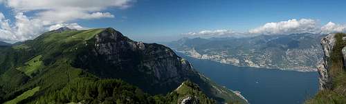 Monte Baldo above Bocca di Navene and Lago di Garda
 Southern view from Monte Laste'


 The monte Altissimo Summit