
-
 10903 Hits
-
 75.81% Score
-
 6 Votes
|
|
Mountain/Rock |
|---|---|
|
|
39.63385°N / 2.48612°E |
|
|
Hiking, Scrambling |
|
|
Spring, Summer, Fall, Winter |
|
|
3369 ft / 1027 m |
|
|
Overview
 Puig de Galatzo seen from the north-east
 |  |  |
One of these mountains with an attitude is Puig de Galatzo, an almost perfectly shaped limestone cone in the south-west of the island. At 1027m it is one of the lowest 1000ers of Serra de Tramuntana but as you usually start the hike close to sea level it still requires about 1000m of elevation gain. And the most difficult sections of the route are at the top where you either have to squeeze up a gully, balancing above a 100m drop or head up an exposed ridge from the north-west.
 |  |  |  |
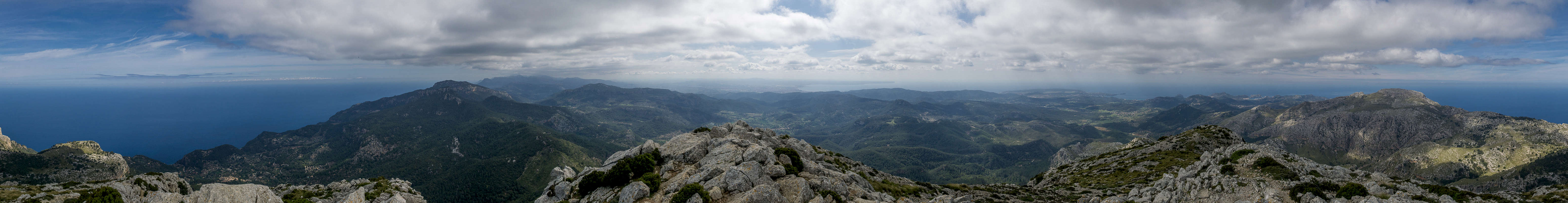
Thanks to its distinctive form, Puig de Galatzo is as much a mountain to be seen as one to look out from. It is visible from almost any other summit of Serra de Tramuntana as far as Puig de Massanella in the north-east. Consequently, in the reverse direction you’ll be able to see as far – provided the weather allows. As you can see from the 360°-panorama below, the whole island lies at your feet.
 |  |  |
Together with its neighbour to the west, sa Mola de s’Esclop, Puig de Galatzo forms the southernmost part of Serra de Tramuntana. The two mountains frame a karst plateau, which is famous for the many wildflowers it contains. Also, occasionally you can encounter wild balearean goats, small animals with striking amber eyes. We encountered a red-legged partridge right on the summit, waiting for us on the summit rock. It didn’t move and simply looked annoyed at the disruption.
360° Summit Panorama
  |
Getting There
 View across Serra de Tramuntana
Puigpuyent
- Take motorway Ma-19 from the airport to Palma.
- Switch to motorway Ma-20, the circumnavigation of Palma.
- Leave it for Ma-1041, direction Puigpuyent
Estellencs
- Take motorway Ma-19 from the airport to Palma.
- Switch to motorway Ma-20, the circumnavigation of Palma.
- Leave it for Ma-1041, direction Esporles
- Switch to Ma-1100, later Ma-10, which will take you to the west coast.
- Drive through the village until you reach an intersection with a dirt road some 1km beyond.
- Alternatively you can take Ma-1043 and Ma-1043 to Calva from Las Palmas.
- There switch to Ma-1015 and Ma-1031 to Andratx.
- Here switch to Ma-10 to Estellencs
Routes
 Ascent gully seen from the summit
From Puigpuyent
The first two thirds of this route run along dirt roads. From the southern part of Puigpuyent follow a road to the west, following signs to the Reserva Puig de Galatzo and the farmhouse Es Cucui. The road turns right (north) and heads for the fount sa Font des Pi. From here a very steep trail on limestone rock heads up the north side of Puig de Galatzo. It passes the striking rock tower es Bispe (the bishop), crosses a choss chute and reaches a saddle where the route from Estellencs joins. Together they wind between huge limestone blocks, heading along a tall rock face. Finally you reach a little kind of “square” (plateau). Straight ahead there is a chimney, which heads up to the summit directly but also drops for about a hundred metres towards the trailhead at sa Font des Pi. The easier option is to turn right (west), climb a few metres towards the short (but also exposed) north-west ridge, which leads you towards the summit.From Estellencs
The longer route starts on road Ma-10 at km 97, where a sign leads to the picnic area Boal de ses Severes. Here another sign leads to Pas des Cossis and a steep path heads for this saddle. Up on the plateau it passes by the summit of sa Moleta Rasa, descending into a shallow valley, then heading up for the next saddle, Pas de na Sabatera. Some steep switchbacks take you to another sadlle, this one in the north face of Puig de Galatzo. Here the route from Puigpuyent joins. See the above description for the remainder of the ascent.Red Tape
 Red-legged partridge (Alectoris rufa)
When To Climb
At little more than 1000m Puig de Galatzò can be climbed in any season. Its summit cone, thanks to its proximity to the west coast, can attract fierce storms in late autumn and winter.Accommodation
Generally, there are lot of accommodation options on Mallorca, which you can find on the usual portals. Prices, however, are quite high.The closest town to Puig de Galatzò is Andratx. Also, a bit further north along the coast, you can find good apartments at Solèr and Port de Solèr.
Weather Conditions
 Moonset over one of the Aleppo Pines seen during the ascent
Maps & Books
There are many publications about hiking on Mallorca. I include the ones which I have used myself as well as recommendations by other SPers. The book by Rolf Götz, which is available in four languages has a good choice of routes, two thirds of them in Serra de Tramuntana. Two routes are dedicated to Massanella.In particular I want to recommend the book by Marc Schichter & Kirsten Elsner, even though it is only available in German. It comes with an excellent map of Serra de Tramuntana (probably the best available) and lots of routes which can be connected at will.
Maps
- Mallorca
4 map box set
Kompass Verlag
1:35000
ISBN: 978-3-99044-062-9
- Walk Mallorca
Discovery Walking Guides
1:40000
ISBN: 978-3-99044-062-9
Books
- Mallorca
Rolf Götz
Rother Verlag
ISBN: 978-3-7633-4805-3 (English)
ISBN: 978-3-7633-4122-1 (German)
ISBN: 978-3-7633-4923-4 (French)
ISBN: 978-3-7633-4701-8 (Spanish)
- Wandern auf Mallorca
Marc Schichter & Kirsten Elsner
Reise Know-How
ISBN: 978-3-89662-289-1
- Walking in Mallorca: Classic Mountain Walks in Mallorca
June Parker
Cicerone Press
ISBN: 978-1852844882