
|
|
Mountain/Rock |
|---|---|
|
|
42.77920°N / 109.2247°W |
|
|
11884 ft / 3622 m |
|
|
Overview
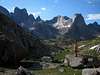
 Pingora Peak was named as such after it's first recorded accent in 1940 by Orrin Bonney, Fank Garnick, and Notsie Garnick. The word Pingora is a Shoshoni term meaning high, rocky and inaccessible peak. In the panorama of the cirque (left), Pingora is the prominent peak to the far right side. Pingora Peak stands guard on the west side of Lonesome Lake, in the infamous Cirque of the Towers. It taunts a rock climber the very second that he or she enters the cirque. The rock quality is rumored to be the best for climbing in all the cirque. There are several climbing routes on this peak, with the easiest being a 5.2. Pingoras Northeast Face route is listed the 50 Classic Climb’s of North America. The only connecting ridge to Pingora is that which tapers down from Wolfs Head. This is a fifth class climb as well. So...if you would like to stand atop Pingora's coveted summit, be prepared for a technical climb (and bring your bug spray!).
 |
Getting There
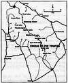
- From Jackson Hole or Pinedale, take Hwy 191 south to Boulder. From Boulder, take WY 353 for eternity until the pavement ends (18 miles). Continue on a dirt road for another 8 or 9 miles to a junction in the road. Turn left and travel 7 miles to another junction in the road. Again, turn left, and follow the signs to the Big Sandy Recreational Area.
- From Rock Springs or anywhere south thereof, take Hwy 191 north to Farson. From Farson, take WY 28 east for 2 miles. Watch carefully for a dirt road going north (left). Take this dirt road for 40 miles! (wow). You should reach a junction where it is marked to go right for Big Sandy Trail. Follow the signage to the Big Sandy Recreational Area.
- From the Big Sandy Recreation Area parking lot, Hike the Big Sandy Trail to Jackass Pass (approx. 7 miles). The hiking is moderate and gets steep only for a short stretch above Big Sandy Lake. You will know exactly where you are once you reach the pass. Bring your camera for this one.
- Once you've reached the Cirque you will certainly know it. Pingora and all of it's splendid nieghbors will be quite apparent. Getting to Pingora should be fairly straightforward from anywhere in the cirque. If you are headed stright for Pingora from the Arrowhead Lake saddle, SP User standinginawe offers the following description: As explained in the Guidebook there is a shortcut trail leading to a saddle between Arrowhead Lake and the Northwest valley above Lonesome lake and directly below Warbonnett, Warrior 1 and Pingora. From Big Sandy, continue on the main trail past North Lake and up to the first saddle which brings you above Arrowhead lake. You will descend slightly, but before the ascent begins towards Jackass Pass, take the faint left trail towards the Northwest and eventually, Arrowhead Lake. Follow the faint trail across the talus field and diagonally upwards towards the sheer walls and base of Warbonnett. Continuing upwards, follow the well established trail behind the large boulder and down the other side. Continue on the trail and across the valley to any one of the killer campsites available. Leave no trace.
 |
 |
Red Tape
- I consider the mesquitos "Red Tape" - Bring a bug net hat and the best bug spray you can find.
Your life will be better during your stay. Early or late season efforts will minimize the "bug factor".
- The rangers are very active in the Wind Rivers. They are also quite adamant about enforcing Wilderness reg.'s in the Bridger Jack Wilderness.
- There is a $5 fee for camping at the Big Sandy Campground (But parking is free).
Essentials
- Gas and Food are available in Pinedale, Boulder and Farson. Be sure to stock up. After leaving Hwy 191, there is nothing but you and the desert.
- Water from Lonesome Lake is very contaminated by human waste, as everything in the cirque drains to the lake. Bring a suitable filtering device and/or hike over the pass to Arrowhead lake to pump water.
- There are Gear Shops in Jackson Hole, if coming from the north. If coming from the south, you can purchase your forgotten essentials in Rock Springs.
- The most popular Guidebook(s) for the area is Climbing and Hiking in the Wind River Mountains, by Joe Kelsey. Chockstone Press, 2nd edition. Climbing Magazine did a nice article on the Cirque of the Towers. You will have to search their archives to get the issue number though.
- As for Maps and Topo's, a Wyoming state map is useful, particularly one covering the dirt roads in/around the Wind River Mountain Range. You will need the "Lizard Head" quad. topo for the cirque area. And, if desired, a "Big Sandy" quad. topo for the hike in from Big Sandy Trailhead.
Camping in the Cirque
- While there are no desginated camping areas in the cirque, there is definitely no camping allowed within 200 feet of the lake or any stream, or within 100 feet of any established trail. If you prefer to avoid the climbing crowds and the poop flavored water, you can camp on the south side of the pass as well. It is only a twenty minute hike from treeline to the pass
Descent
This descent is offered by contributor Geoff Ruttan:
The regular descent is down the South Ridge.
From the summit follow easy ground SSE, follow the ramp that gradually curves right (straight south). Scramble down and a bit back to climbers right to a ledge on the South Ridge. The first rap is 30m.
From the huge ledge scramble down about 10m to a rap station (climbers left). From here do a 60m rap, then a 30m rap, then one more 60m rap to the ground. (4 raps in total)
It is possible to use one 60m rope and rap the route. (6 raps in total) Be wary of one station that looked manky.
External Links
- Bridger Wilderness Regulations
Do's and Dont's while within the Wilderness boundaries. - Alan Ellis' Pingora Page
Trip report with photos and route description of the South Face route.
jwclimbs - Sep 11, 2005 4:02 pm - Hasn't voted
Untitled CommentThanks for the beta - I'll format it into the page.
-JW
standinginawe - Sep 8, 2005 6:53 pm - Hasn't voted
Untitled CommentAs explained in the Guidebook there is a shortcut trail leading to a saddle between Arrowhead Lake and the Northwest valley above Lonesome lake and directly below Warbonnett, Warroior 1 and Pingora. From Big Sandy, continue on the main trail past North Lake and up to the first saddle which brings you above Arrowhead lake. You will descend slightly, but before the ascent begins towards Jackass Pass, take the faint left trail towards the Northwest and eventually, Arrowhead Lake. Follow the faint trail across the talus field and diagonally upwards towards the sheer walls and base of Warbonnett. Continuing upwards, follow the well established trail behind the large boulder and down the other side. Continue on the trail and across the valley to any one of the killer campsites available. Leave no trace.
jwclimbs - Sep 11, 2005 4:02 pm - Hasn't voted
Untitled CommentThanks for the beta - I'll format it into the page.
-JW