

-
 172235 Hits
-
 94.72% Score
-
 49 Votes
|
|
Mountain/Rock |
|---|---|
|
|
37.09440°N / 118.5019°W |
|
|
Mountaineering, Trad Climbing, Scrambling |
|
|
Spring, Summer, Fall, Winter |
|
|
14153 ft / 4314 m |
|
|
Overview
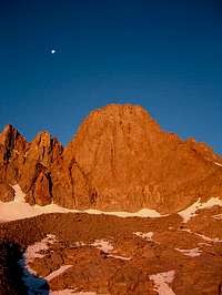
This distinctive thumb-shaped peak (when viewed from the north and east) is one of the most visible of Sierra landmarks. It is easily seen from the town of Big Pine, the Sherwin grade north of Bishop, and the White and Inyo Mountains.
Joseph LeConte named the peak in memory of Edward Rowland Sill, a poet and teacher in the Oakland area and at the University of California. Before Europeans came along it was known to the local Paiute, who worship it in their ceremonies, as Nee-ma-mee-shee (Guardian of the Valley).
Mount Sill is the second-highest peak in the Palisade Range (North Palisade is 89 feet higher). The first recorded ascent was in 1903 by Joseph LeConte, James Moffitt, James Hutchinson, and Robert Pike, who ascended the Southwest Slope. Mount Sill has attracted climbers since the earliest days of mountaineering in the Sierra, including such luminaries as Walter Starr Jr, John Mendenhall, and Norman Clyde. There are at least 10 established routes on the peak, ranging in difficulty from class 2/3 to 5.10. The classic route is the 1938 Swiss Arete, which ascends the rib above Glacier Notch.
Its summit provides a commanding view of the entire Palisade range and surrounding peaks. Indeed, R.J. Secor opines that, "Mount Sill has the best summit view of any peak in the Sierra." While such a judgment is certainly subjective, it is indicative of the reward awaiting those who reach its summit.
Getting There
There are many ways to get to Mount Sill, but most routes begin either from Glacier Lodge or South Lake. Glacier Lodge is at the end of Glacier Lodge Road, which heads west from the town of Big Pine on US 395. South Lake is reached by driving west on Highway 168 out of Bishop until you come to the intersection with South Lake Road. Turn left on South Lake Road, and follow it to the hiker parking area at the end above the dam.
Below are three possible approaches starting from Glacier Lodge. A topo sketching out a few more options is here.
1) Hike the North Fork of Big Pine Creek, camp just below the Palisade Glacier. Glacier Notch - which separates Mount Gayley from Mount Sill - may be a bit harder to reach from this side because it involves crossing a bergschrund and some class 3 rock below the notch. However, the hike in is easier than the cross-country South Fork approach. Glacier Notch is the start of the Swiss Arete and North Couloir routes.
2) An enjoyable and less crowded approach to Mt Sill follows the South Fork of Big Pine Creek (cross country, class 2), to base camps somewhere below Mount Gayley and Temple Crag. Much talus is encountered on this approach.
3) To gain the Southwest slope of Mount Sill, you may hike the SF of Big Pine Creek up to Elinore Lake and then on over Scimitar Pass (~13,200ft). Follow the crest past Mt. Jepson into the basin at the base of Sill and Peak 13961. Polemonium Glacier terminates in this basin.
From South Lake hike over Bishop Pass, skirt the Palisades' Western aspect over Thunderbolt Pass and Knapsack Pass to gain the Southwest slope of Mount Sill.
Routes
| Route | Grade | Notes |
|---|---|---|
| Southwest Slope | Class 2/3 | FA 1903 by Joseph LeConte, James Moffitt, James Hutchinson, and Robert Pike. From the Cirque between Sill and Polemonium Peak, follow the west ridge to the summit. The talus becomes larger and steeper near the top. |
| Traverse from U-Notch and Polemonium | 5.2 | FA 1933 by Lewis Clark, Ted Waller, Julie Mortimer, and Jack Reigelhuth. |
| North Couloir | Class 4 | FA 1931 by Walter Starr Jr. The standard route from the north. Start at Glacier Notch, ascend the L-shaped couloir to another notch. Traverse across the northwest face on loose class 3 ledges. Climb a short section of class 4 to reach the west ridge and easy scrambling to the summit. |
| Swiss Arete | II 5.7 | FA 1938 by Spencer AUstin, Ruth Dyer, Ray Ingwersen, Richard Jones, and Joe Momyer. A classic moderate route. |
| East Chimney | III 5.8 | FA 1960 by Tom Condon and Fred Kipfelsberger. Ascends the magnificent East Face. |
| East Face | III 5.7 | FA 1963 by John Mendenhall, Rich Gnagy, Burt Turney, and Genevieve Turney. Ascends the magnificent East Face. |
| Larry's Pillar | III 5.10 | FA 1978 by Mike Farrell and Mike Graber. Named by two guides at the Palisade School of Mountaineering in honor of their late director Larry Williams. |
| East Couloir | Class 3 | First descended in 1934 by Norman CLyde, Hervey Voge and David Brower. |
Red Tape
Wildernes permits are required for overnight use. The peak straddles the Inyo National Forest/John Muir Wilderness and Kings Canyon National Park. Unless you are coming from a long way away, your approach will begin in the INF.
Permit reservations may be obtained by calling (760) 873-2483, by FAX (call the previous # for the FAX number), or by writing to:
Inyo National Forest
351 Pacu Lane
Suite 200
Bishop, CA 93514
Permits can be picked up in Lone Pine at the Eastern Sierra InterAgency Visitor Center at:
Intersection of Highway 395 & State Route 136
2 miles south of Lone Pine
(760) 876-6200
or at the White Mountain Ranger Station in Bishop at:
798 North Main Street
Bishop, CA 93514
760-873-2500
760-873-2501 TDD
Hours: 8:30 am to 4:30
Open all year
Monday-Friday in winter
The usual backcountry rules apply: camp at least 100 feet from water, pack out your trash, no wood fires, etc.
When To Climb
The mountain can be and is climbed at all times of the year. While there is nothing to match the solitude, quiet, and incomparable beauty of the winter, avalanches are a reality. Be prepared for difficult conditions and to assess avalanche potential if you head up in the winter.
Spring and early summer can offer good travel conditions on South Fork approaches, as the copious talus is largely buried.
There are many resources available to find out current conditions in the area:
Staff at the White Mountain Ranger Station can provide current conditions during the summer months (though they may be a bit on the conservative side if asked about the need for foul weather gear, crampons, etc.) Information on winter/spring snow conditions can also be found on the web:
Snowpack conditions
Avalanche Hazard (winter only)
Camping
There are several Forest Service campgrounds along the road to South Lake as well as in the Big Pine Creek area. Check out the Forest Service website for details. Campground fees are a bit steep (except for First Falls walk-in, which is free). I've never had a problem sleeping in my car or next to it at a trailhead.