
|
|
Mountain/Rock |
|---|---|
|
|
38.66360°N / 120.0015°W |
|
|
Hiking, Mountaineering |
|
|
Spring, Summer, Fall, Winter |
|
|
10381 ft / 3164 m |
|
|
Overview
THIS PAGE HAS BEEN ADOPTED.
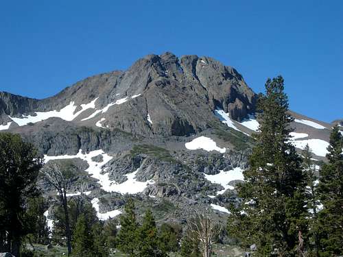
Round Top is the jaw-dropping peak situated south of Carson Pass off California State Route 88, a primary hiking area located about 17 miles south of Lake Tahoe as the crow flies. It is also one of the more prominent peaks in the area with a prominence of over 2,500'. Its distinctive rounded summit of dark volcanic basalt towers above a beautiful alpine country that is rare in this part of Sierra Nevada. Round Top is located in the Mokelumne Wilderness and the Carson Pass Management Area and is a nice side trip for those traveling the Pacific Crest Trail.
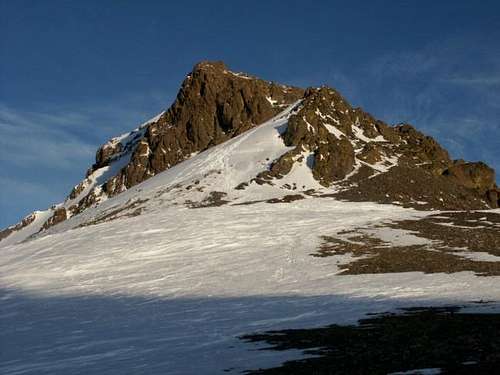
Round Top offers views south towards Ebbets and Sonora Pass, east toward Hope Valley and the Carson River, west overlooking Caples Lake and the Kirkwood Ski area and northward one can see Lake Tahoe. If the air is very clear, Mount Diablo in the East San Francisco Bay area can be seen. Because of its close proximity to the South Shore of Lake Tahoe and the Kirkwood ski resort, it is also a popular destination for ski touring and mountaineering. On holiday weekends it can be tough finding a parking space and the trail seems like a crowded highway. Its easiest route via the west ridge is class 2 leading almost to the summit. However, the true summit block (the eastern crag) is rated class 3. In fact, most people who hike Round Top do not visit the true summit, which does take some additional time. The summit itself is pretty small and standing on top of it is like standing on the top of an SUV. The final stretch to the summit is very similar to the final stretch to Castle Peak north of Truckee.
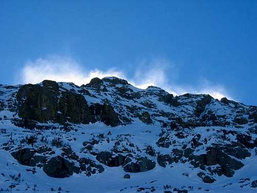
All other routes are generally pretty difficult or technical. On its north and east sides there are some challenging volcanic cliffs.
 |
 |
 |
 |
 |
Getting There
There are two trailheads for this peak. The first is Carson Pass, and the second is Woods Lake. Getting to Carson Pass is easy. From Highway 395 south of Carson City, Nevada, head to Minden, Nevada. Just before entering town, take Highway 88 as it winds south towards Carson Pass in California. It is about 28 miles from the 395/88 junction in Minden to Carson Pass. To get to Woods Lake, go past Carson Pass for 1.7 miles west, and a paved road is on your left. The paved road heads shortly to a parking lot. From Central California, it is about 70 miles east of Jackson on Highway 88.
For the standard route, the hike will only take a few hours. More technical routes may be longer, but none require much mileage. More details are on the route pages.
 |
 |
 |
 |
 |
Red Tape
The Carson Pass Management Area covers the area immediately around and including Round Top Peak and governs regulations. During the summer a $5.00 day use fee is charged at the Carson Pass, Carson Pass Overflow, Woods Lake, and Meiss trailheads. Your National Parks and Federal Recreation Lands Pass is good here. A season permit can be purchased for $25.00. If visiting the area in winter, a Snow Park Pass is required. These can be purchased at any Forest Service office and at many retail stores. Many AAA offices also sell Snow Park Permits. The closest place to obtain a Snow Park permit is the gas station next to the Kirkwood Nordic center 6 miles west on S.R. 88. If one is camping, in any part of the wilderness other than the Carson Pass management Area, a Wilderness Permit is needed and can be ordered from any El Dorado National Forest Ranger office, from the Carson Pass Information Station at the trail head in summer or the Amador Ranger Station which is located at 26820 Silver Drive Pioneer, CA just off of Highway 88, about 3 miles east of Pioneer and is open Monday through Friday. The phone number is (209)295-4251. Only one permit is needed for continuous trips passing through more than one wilderness area. Maximum group size for a day hike is 12 people. Only 8 people for an overnight stay. If you plan on using a stove, even if on a day hike, a fire permit is required and can be picked up at any U.S. Forest Service office. The fire permit is good for the entire state of California. There are no wood fires allowed above 8000 ft.
When To Climb
The peak can be climbed year round with some good winter ski runs. For those desiring to avoid snow and ice, it is best to hike here between late June through early October.
 |
 |
 |
 |
 |
Camping
Camping is allowed in the Mokelumne Wilderness with the proper permit. The restrictions for the Carson Pass Management Area are more restrictive than the rest of the wilderness area. There is no summer camping at Frog Lake. There are three sites at Winnemucca Lake, six sites at both Round Top Lake and Fourth of July Lake. Winter camping is allowed once the snowpack is 12 inches deep. From the Friday before Memorial Day through Labor Day weekend, an overnight stay limit will be in effect of 2 nights for Round Top and Winnemucca Lakes and 3 nights for the Fourth of July Lakes. Permits can only be obtained at the Carson Pass Information Station in the summer and the Amador Ranger Station at all other times of the year. Down from the pass in both directions are regular Forest Service fee campgrounds. The closest being Woods Lake and Caples Lake to the west for summer camping only. There are also a couple of stores and restaurants fairly close to the west at Caples Lake and Kirkwood. Use a bear canister to store food in order to deter marauding bears.
 |
 |
 |
 |
 |
Mountain Conditions
Highway conditions can be found at Caltrans online by searching for Highway 4 or SR 88, or by phoning the California Department of Transportation road condition line at 1-800-427-7623.
 |
 |
External Links and Trip Reports
- All Trails - Round Top from Carson Pass
- Morgan, Kim, Robert: West Ridge Ski Descent
- West Ridge - March 23, 2001
- Crescent Moon Couloir - Feb 16, 2002
- West Ridge - July 28th, 2002
- A Carson Spur-Pass Traverse - April 4, 2004
Matthew Holliman - May 27, 2003 12:56 am - Hasn't voted
Untitled CommentCamped near Caples Lake (formerly called Summit Lake or Clear Lake), 1863:
"August 17--I climbed alone a high peak south, over 10,500 feet high--a steep, heavy climb. I had to carry a barometer, bag with lunch, thermometer, levels, hammer, etc., a canteen, and my botanical box. We have had high winds for several days, and in the morning clouds enveloped the summit of the peak, but they fled before I reached it. The last eight hundred or a thousand feet rise in a steep volcanic mass, so steep as to be only accessible in one place, around cliffs and up steep slopes on the rocks, but there was no serious difficulty or danger. A cold, raw, and fierce wind swept over the summit, but the day was very clear and the view sublime. The peak is just south of Carson Pass, and some twenty to twenty-five miles south of Lake Tahoe (Bigler). The lake was in full view its whole extent--my first sight of it--its waters intensely blue, high, bold mountains rising from its shores. I am higher than the great crest of the Sierra here and hundreds of snowy peaks are in sight. Hope Valley lies beneath, green and lovely--high mountains, eleven thousand feet high rising beyond it. Besides Lake Tahoe, there are ten smaller lakes in sight, from two miles long down to mere ponds (which were not counted)--all blue, of clear snow water. It was, indeed, a grand view.
I descended by getting on a steep slope of snow, down which I came a thousand feet in a few minutes where it had taken two hours' hard labor to get up."
- William Brewer, Up and Down California