
|
|
Mountain/Rock |
|---|---|
|
|
37.79937°N / 107.54581°W |
|
|
Mountaineering |
|
|
Summer |
|
|
13478 ft / 4108 m |
|
|
Overview
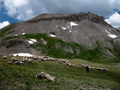 Canby Mountain from near Stony Pass
If you let your 4 wheel drive vehicle do most of the work, you can bag this one with minimal effort.
Canby Mountain rises directly to the east of Stony Pass, a historically important access route to the 19th century mining boomtowns of southwest Colorado. In early 1870s a wagon road was constructed between the now ghost town of Howardsville and the town of Creede via Stony Pass. This road was so rough that in some places the wagons had to be disassembled and carried on horse back. Despite this, Stony Pass Road remained a vital link to the outside world until 1882 when a narrow gauge railroad was completed between Durango and Silverton. Today, Stony Pass Road is maintained as a moderately rough 4 wheel drive road giving access to the Weminuche Wilderness.
Canby Mountain sits on the Continental Divide. Water to the north and west of Canby drains to the Pacific Ocean while water to the south and east finds its way to the Atlantic Ocean. Canby has a flat and relatively large summit that is surrounded by a continuous band of cliffs except for a small area on its north ridge which provides easy access to the summit.
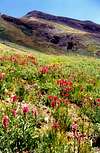
From the summit you can take an unobstructed look into the heart of the San Juan Mountains. Much of the land to the south of Canby consists of grassy plateaus that rise above timberline (12000 ft). To the south and east, you can identify the humble beginnings of two small creeks that join and eventually become the mighty Rio Grande River that forms part of the border between the United States and Mexico. Occasional vehicles that inch their way toward Stony Pass are well visible below. The most dramatic view, undoubtedly, is that of the jagged Grenadier Mountains to the southwest. With countless 13er peaks that rise to a maximum elevation of 13864 ft (Vestal Peak), these mountains appear as a harsh jumble of cliffs and spires that are in sharp contrast to the peaceful green plateau above which they rise.
Canby Mountain is seldom climbed. The summit registry indicated that in 2001 only 11 people had made it to the top.
 |  |  |  |
Getting There & Route via Stony Pass Rd.
WITH 4WDTrailhead Elevation: 12588 ft (Stony Pass)
One way distance per my GPS: 0.5 miles
Approximate Hiking Time (one way uphill): 1 hour (up scree and gravel that is not difficult to hike)
Maps: US Geological Survey, Colorado (Howardsville grid), I also recommend Drake Mountain Maps, "Map of the Mountains of Silverton, Telluride & Ouray" (scale 1:60000), (this map shows the details of Stony Pass Road).
From Silverton drive 4 miles east on Route 110 (a well-graded dirt road passable by any car) to the ghost town of Howardsville where you will see a sign for "Creede via Stony Pass". Follow the sign and turn right on Cunningham Creek Road (also a well-graded dirt road). The road splits into two branches that go parallel to Cunningham Creek, one 200 ft or so above the other. You can take either one. They soon rejoin(I only drove the upper road). The upper road takes you by an old mine where you can take a tour.
1.5 miles after Howardsville, you will reach the junction of the 4 wheel drive road to Stony Pass (10100 ft). This junction is well signed. Turn left on this road and follow it up a few switchbacks on a steep slope through a forest of Aspens and Pines. You will have spectacular views of steep drop-offs below and towering mountains above. At around 11500 ft, you will go above the timberline and enter a gently sloped valley that is covered with grass and wild flowers. Stony Pass is reached 3.5 miles after the start of the 4 wheel drive road. This is your trailhead.
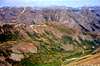
 Canby Mountain
Look up the slopes of Canby to the east and plan your route to avoid the cliffs (see photo in this section). The lower cliffs can be avoided by hiking up a grassy slope to the right (south) of them. Once above the lower cliffs, turn left (north) and hike diagonally up and across a scree slope below the upper cliffs. Farther up, the scree turns into gravel. You will soon reach the north ridge of Canby which is free from cliffs. Turn back right and follow the ridge to the summit.
Without 4WD
If you don't want to feel like you cheated yourself by driving to Stony Pass, you can park at the beginning of the 4 wheel drive road and hike the road. This will increase your one way distance to 4 miles and your vertical gain to almost 3400 ft.
Red Tape
No fees or permits for day hikesFor all rules and regulations see the site for San Juan National Forest.
 |
When To Climb
Easiest in summer. Stony Pass Road is closed in winter.Click to see the forecast for the nearby town of Silverton.
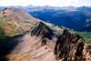
 Canby Mountain from Galena Mountain