

-
 12575 Hits
-
 87.76% Score
-
 25 Votes
|
|
Mountain/Rock |
|---|---|
|
|
46.36283°N / 9.83932°E |
|
|
Mountaineering, Trad Climbing, Ice Climbing |
|
|
Summer |
|
|
11788 ft / 3593 m |
|
|
Overview
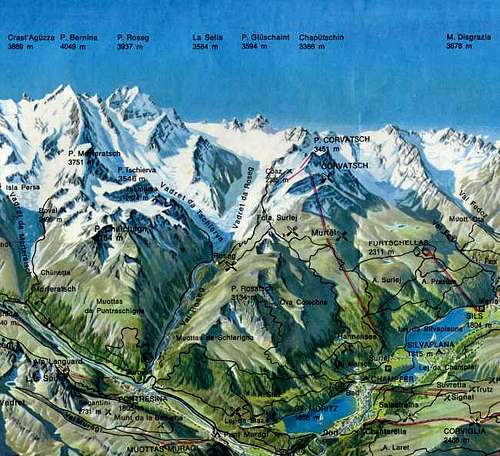
Geographical classification: Alps - Eastern part > Bernina Group > Piz Glüschaint
Piz Glüschaint 3594 m
This page will be kept in honour of Stefan Weber, the SP member known as kletterwebbi, the former owner of this page, died on May 28th 2004 in Southern France at the age of 37.
Piz Glüschaint 3594 m is located in the Bernina Massif on the border between Italy and Switzerland at the closure of the Val Roseg. It's the highest peak of the subgroup Glüschaint-Sella and the Westernmost one. This mountain group limits the left (West) border of the Roseg-basin and Roseg valley. Piz Glüschaint rises above the Vadret da Roseg (Roseg glacier), which is one of the most disrupted glaciers of the alps. The romanic name "Glüschaint" comes from "glühen" (to glow) and "scheinen" (to shine). The mountain is built by three main ridges: SW, NNE and SE. The SW ridge descends to the Forcola Alta giving origin to a fore-summit called Glüschaint Pitschen (Little Glüschaint), the NNE ridge forms a mixed ridge overlooking the Vadret da Roseg, while the brief SE ridge descend to the saddle between Piz Glüschaint and Cima Sondrio. Between this ridges three faces are located: the NE flank, the mixed NW wall, steep but low, and the S face, high and complex, overlooking the italian side with its wide gullies and spurs.

West of the Piz Glüschaint (between Piz Glüschaint and La Muongia, 3415 m) the Fuorcla dal Glüschaint (3369 m) can be found. East of the Piz Glüschaint an insignificant saddle without any name connects the Piz Glüschaint with the group of the Sellaspitzen/La Sella (3584 m). All routes of the Piz Glüschaint need caution because of the many, tremendous, dangerous crevasses of the Vadret da Roseg (things like "seeking for holes" or "minefield" ...).


The common route is the NE-flank (rated Alpine PD). There is no real easy route to the summit. Ongoing decline of the glacier may prevent some of the routes in future.
Getting There
The common place to start an attempt to Piz Glüschaint is the Chamanna Coaz (SAC, 2610 m). The Chamanna Coaz can be reached from the Hotel Roseg at the Val Roseg or from the Fuorcula Surlej.
To go to the Hotel Roseg start at Pontresina (near the railway station) using a good road. This road is closed for cars, but it's possible to take a coach, starting at the railway station of Pontresina (expensive !). By feet it will take about 1,5 hours to reach the Hotel Roseg. From the hotel a path leads up the flat Val Roseg. After about 1/4 hour a marked path to the Chamanna Coaz bends off right hands. Take about 3 hours from the Hotel Roseg to the Chapanna Coaz.
A more comfortable possibility is to start at the Fuorcla Surley. To reach this one you have to use the cable car to the Piz Corvatsch. Leave the cable car at the middle station. From there a brief walk about 1/2 hour to the Fuorcla on a big crowded path. It's also possible to reach the Fuorcla Surley from the valley (St. Moritz or Silvaplana), this itinerary may take about 3-4 hours. From the Fuorcla Surley a well marked path leads to the Chamanna Coaz, it's a real nice path with a very impressive view to Piz Bernina and Piz Roseg above the Val Roseg. Over all, it will take about 2,30 hours from the cable car to the Chamanna Coaz.
Note: The Chamanna Coaz is often crowded. Many people know how beautiful the path and the whole region is. So announce your overnight stay at the hut (phone : 082 - 66278). For the S-face start at the Rifugio Marinelli CAI, 2813 m), 4 hours from Campo Moro which will be reached by car from Chiesa in Italy. The Rifugio Marinelli also can be reached from ChamannaCoaz (6 hours) using the Fuorcla Sella or from the Boval hut/Diavolezza crossing the Fuorcla Bellavista (5 hours).
Routes
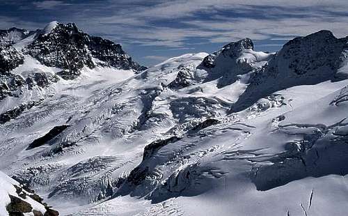
The huge and very crevassed Roseg glacier, with Piz Glüschaint and Piz Sella to the right and Piz Roseg to the left, after a September snowfall partially covering the crevasses
The Vadret da Roseg is one of the most disrupted glaciers of the Alps, so all routes to Piz Glüschaint need a lot of caution. The view from the Chamanna Coaz to the glacier shows the situation. It's a must to study the route at the glacier from the hut, also don't be shy and ask the guardian of the Chamanna Coaz.
NE-flank Regular route, Alpine PD, 6 hours from Chamanna Coaz
From the hut follow a good visible, short path leading to the Vadret Roseg. The first thing is to reach a point at the base of the N-ridge of the Piz Glüschaint (a lot and big crevasses). The possible routes depends on the conditions, a possible one (in 2002) with a big zig-zag can be seen at the routes overview photo. Sometimes it may be possible to reach the base of the N-face more direct.
From the base of the N-face the glacier valley between Piz Glüschaint and La Sella is used for the route (crevasses !). The glacier is used to reach the highest possible point at the base of the summit. The final part is done by the upper part of the N-ridge (or sometime the upper part of the E-ridge).


NW wall Alpine AD-, III, 6 hours from Chamanna Coaz
SW ridge Alpine AD-, III, 3 h from Fuorcla Fex-Scerscen, 7 hours in total


NNE ridge Alpine AD-, III/45°, 6 hours from Chamanna Coaz The rating for the NNE ridge - former known as a good ice route for beginners - seems to be incorrect (in my opinion). The former easy snowfields are gone. Instead of this my friends and me found a steep (50° or more) ice-field with difficult and even dangerous mixed climbing (we aborted the attempt).
S-face + E-ridge Alpine AD+, III-IV, 8 h from Rifugo Marinelli
Red Tape
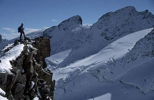
La Sella and Piz Glüschaint from SW-ridge of Il Chapuetschin
You don't need any permissions and you have not to pay any kind of fees.
Hut

Coaz-Hütte 2.610m (Chamanna Coax)
Situation: West of Piz Roseg / Piz Bernina on Roseg Glacier
Open: end of March - 15 of May (make reservations!) and 15 of june- 30 of September
Size: 85 beds
Getting there: Pontresina via Val Roseg: 5 hours on path, from Silvaplana (lift to Surlej): 3 hours
Hut's phone: +41 (0)81 842 62 78 - Hut's reservation phone: +41 (0)81 842 62 78
Camping
There are two campgrounds at Pontresina, one directly at the crossing Pontresina / St. Moritz about 3 km NW of Pontresina. The other one - Camping Plauns - can be found abount 5 km SE of Pontresina below the morteratsch glacier (direction Bernina Pass). To climb the Piz Glüschaint most people will start at the Chamanna Coaz.
When To Climb
Best in early summer, because the conditions of the Vadret da Roseg may turn very bad in late summer.
Meteo
Guidebook and map

"Bernina" - N. Canetta, G. Miotti - Collana Guide dei Monti d'Italia CAI-TCI
"Bernina & Bregaglia Selected Climbs" - Lindsay Griffin ISBN: 0900523603 Alpine Club (http://www.alpine-club.org.uk/)
"Berninagruppe" Gebietsführer für Wanderer, Bergsteiger und Hochalpinisten - Walther Flaig ISBN: 3763324178 Bergverlag Rudolf Rother, München
"Clubführer SAC Bündner Alpen band 5" ISBN: 3859021311
The N-ridge is also described in the out-of-print-book "Bernina - die 100 schönste Touren", but the description there doesn't match the real situation any longer.
"Bernina" sheet 1277 - CNS 1:25.000
Mountain Conditions
 Overview on the Bernina...
The best place to get informations about the actual weather conditions is the Meteo Schweiz website. Informations about mountain conditions also can be found at the homepages of St. Moritz or Pontresina.
In Memory of Stefan "kletterwebbi" Weber
 At the summit ridge of the...
A note from the SP staff Stefan Weber, the member we all used to know from his climbing pseudonym kletterwebbi, died on May 28th 2004 in Southern France at the age of 37.
Stefan joined SP early on in 2002 and contributed a number of excellent pages and routes to this site. He was an accomplished climber excelling in difficult alpine and technical routes. The Dolomites, especially the area around Gröden / Val Gardena were special to him, as it was his old ancestral home.
kletterwebbi was always willing to share his knowledge and experience with other climbers, mainly here on SP, but also on other sites. He contributed his IT expertise as webmaster of his local section of the German Alpine Club, where he also engaged in leading trips for fellow members. Besides his climbing and mountaineering activities he was a musician, a composer of contemporary music. Stefan will be greatly missed by us all.
This page will be kept in honor of kletterwebbi, one of SP's most talented, knowledgeable members, and without a doubt, one of our greatest fellow mountaineers.
selinunte01 - Jul 22, 2009 4:01 pm - Hasn't voted
Southwest arete - importantIn the old guide books, southwest arete is rated as UIAA II. In july 2009 I was informed by the guardian of the Coaz hut, that, due to glacier retreat, the passage from the glacier upon the rocks of Fuorcla dal Glüschaint is becoming more and more difficult. In periods with low snow there is now a 40 m high (!!) wall with loose rocks and UIAA grade IV (!) before you get on Fuorcla dal Glüschaint. A fixed belay for rapelling will be installed soon this year (2009) to facilitate the descend.