
|
|
Mountain/Rock |
|---|---|
|
|
43.35000°N / 18.12000°E |
|
|
6446 ft / 1965 m |
|
|
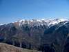
Overview
Visocica lays in the very eastern part of Konjic municipality - toward Sarajevo. All borders of Visocica are rivers – eastern Ljuta, western and northern Rakitnica and southern Neretva.
Its northern and western hillsides slope steep to Rakitnica whereas its eastern and southern parts mildly descend to Bjelimici plateau that ends steeply in Neretva valley.
One deep and wide valley – Veliko Jezero (Great Lake) that starts in the southeast at 1660m and ends in the northwest at 1420m divides Visocica massif into northern and southern part.
Another valley starts in the northeast at Mandin Do (1700m) and gradually deepens to the southeast untill it become steep and narrow Kolijevka which ends at Luka village (1200m). This valley divides the massif into eastern and western part.
Northern massif consists of ridges Spionik, Kaoci, Vito (1960m) and Toholj. The massif is wild and romantic – full of pointed peaks with narrow valleys among them. There is no any forest (even juniper bush (Pinus montana)) on hillsides of those ridges.
Southern massif is actually ridge Ljeljen (Ljeljen - old bosnian word for deer) which is not only the biggest but the highest ridge of Visocica. The highest summit of this ridge and whole Visocica is Dzamija - 1974m. (Dzamija means “mosque”. Centuries ago, during the long droughts, people (muslim) from Visocica villages climbed to the summit to pray for rain). There is no forest on this ridge neither – only clods. High beech forest grows only up to 1400m at its southern foothill.
Western sides of the mountain are Ivica and Gruscanska Gora. Ivica slopes steeply to Rakitnica river – the slope is cca 20% (400m) on the length of 2000m. Gruscanska Gora slope to Rakitnica to at rate of 10% (400m on the length of 4000m).
Eastern massif consists of ridges Lucka Gora, Glatko, Kom, Crveni Kuk and Puzim. These ridges are either covered with forest or meadows from bottom to the top. The exception is only Puzim with its rocky and pointed summit.
There is a beautifull view from Visocica summits of the mountains which surround it – in the north Bjelasnica and Hojta, in the northeast Treskavica , in the east Zelengora and Lelija, in the south Velez and Crvanj, in the west eastern parts of Prenj mountain (Osobac, Borasnica, Otis).
Layers of waterresistant shale make the mountain rich with springs just at bottoms of summits – Mandino vrelo (Mandas spring) at 1720m, Vukova voda at 1850m (under the summit Vito), Hotanj (under Ljeljen ridge) at 1520m etc.
There are no lakes on the mountain. However, during the spring (after melting of snow) some valleyes are full of water – called “lakes” by local shepherds.
Western, northern and eastern parts of the mounatin (till the height of 1600m) are overgrown with high forest , mostly decisuous trees – beech and maple. Southwestern hillsides are overgrown with coniferous forest – pine and spruce. Southern hillsides end as hilly, quite fertile plateau. Above 1600m there are no more trees – only meadows with many medicinal herbs.
There are no permanent settlements in the central area of Visocica – only shepherds from Grusca and other villages at the foothilh inhabit Visocica during summer periods. All of them are muslims.
Many bogomil graveyards can be seen on the mountain. Especially interesting are two of them – first at the northern end of Kolijevka (cca 1510m) and second in the Veliko Jezero valley (on the northeast of Ljeljen) at 1660m.
Note: Above descriptions of Visocica are taken from the book "Planine u Bosni i Hercegovini" (1935g) by ing. Jovan Popovic.
 |  |  |  |  |
Getting There
You can reach the mountain either
1.from Konjic (via Boracko Lake and further on to village Bjelimici or Grusca) or
2. from Sarajevo (via Lukavica, Krupac, Babin do, village Sabici till Sinanovici). Just close to the village Sinanovici, to the left, is situated mountain hut od Mountaineering society Treskavica (former school). Two marked trails lead from there - one to the left to peak Vito (cca 1950 nm). It takes approx. two hours to reach the peak. From Vito you need cca 3 hours to reach the highest peak of Visocica (Dzamija) ...
 |  |  |  |  |
Red Tape
No permits are required.
 |
When To Climb
You can climb (hike) whole year - only need a good 4x4 vehicle to get to the base point ...
 |  |
Camping
There are no mountain huts there but you can always find a cheap bed in a peasent's house ...
External Links
- A page on Visocica
This website www.oueston.net is full of pictures and text about bosnian mountains.