
|
|
Area/Range |
|---|---|
|
|
44.34040°N / 15.47480°E |
|
|
Hiking, Sport Climbing, Bouldering, Big Wall |
|
|
Spring, Summer, Fall, Winter |
|
|
4511 ft / 1375 m |
|
|
Google Earth
Since Google has blessed us with its magical Google Earth software you can visit any corner of the world from the chair parked in front of your computer. Thankfully Velebit is amazingly clear so you can discover its corners and see for yourself how it looks from the above and where are the places this page is dedicated to.
Each geographical point of interest described on this page has coordinates on the top of its section. You can use these coordinates with Google Earth’s fly to search engine. Just copy the coordinates (like it is written, with coma) and paste them into fly to tab and press enter. And, of course, enjoy the flight!
Intro
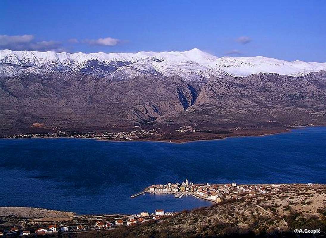
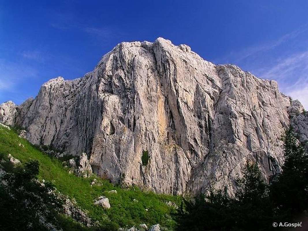
Canyon of Mala Paklenica with Sveto Brdo (1751m)
 Seaboard side of Velebit, its 1st step to be exact, is furrowed by numerous small gorges and wild torrents which used to take waters from high parts of the mountain towards sea. They date from times when rains and snows were abundant, especially in glacial periods. That is why the shore of Velebit is very indented. Mouth of each gorge or torrent today, after sea level raised, is bay or cove. Some of them are wild and impressive like Zavratnica bay near Jablanac or Kozjaca torrent near Sibuljina. But there is one special place by the coast where water, helped with tectonic activity, opened its way towards sea cutting straight through Velebit massif. On its way it left two deep unhealed wounds, impressive canyons of Velika Paklenica and Mala Paklenica. This page is dedicated to them, which are the heart of the NP, and surrounding area where one can find many attractions and numerous hiking and climbing possibilities. Seaboard side of Velebit, its 1st step to be exact, is furrowed by numerous small gorges and wild torrents which used to take waters from high parts of the mountain towards sea. They date from times when rains and snows were abundant, especially in glacial periods. That is why the shore of Velebit is very indented. Mouth of each gorge or torrent today, after sea level raised, is bay or cove. Some of them are wild and impressive like Zavratnica bay near Jablanac or Kozjaca torrent near Sibuljina. But there is one special place by the coast where water, helped with tectonic activity, opened its way towards sea cutting straight through Velebit massif. On its way it left two deep unhealed wounds, impressive canyons of Velika Paklenica and Mala Paklenica. This page is dedicated to them, which are the heart of the NP, and surrounding area where one can find many attractions and numerous hiking and climbing possibilities. |
 |
 |
 |
 |
 |
Overview
Entrance into the canyon of Velika Paklenica
 Even on a mountain that is so beautiful and unique there are places which stand out. Paklenica is such place. It is placed on South Velebit, below highest peaks of the mountain (Vaganski Vrh – Sveto Brdo group). Highlight of the area are both Paklenica canyons. To explain how they were created we have to travel back in time, around million years. During that time there were several glacial periods. Decomposing of rock was then far more expressed than it is today. Underground water channels weren’t yet formed and there was no forest. Rains and snows were plentiful making surface flows and erosion very strong, tectonics were stronger too, all of which ultimately led to formation of Paklenica canyons. Even on a mountain that is so beautiful and unique there are places which stand out. Paklenica is such place. It is placed on South Velebit, below highest peaks of the mountain (Vaganski Vrh – Sveto Brdo group). Highlight of the area are both Paklenica canyons. To explain how they were created we have to travel back in time, around million years. During that time there were several glacial periods. Decomposing of rock was then far more expressed than it is today. Underground water channels weren’t yet formed and there was no forest. Rains and snows were plentiful making surface flows and erosion very strong, tectonics were stronger too, all of which ultimately led to formation of Paklenica canyons.Today this is area of exceptional natural beauty and various geological formations in abundant karst where cliffs, caves, holes and cracks are numerous, where tireless work of water furrowed rock so much that it created examples which are pure natures work of art, we call them skrape. Above all are magnificent canyons of Velika & Mala Paklenica. Fauna is rich with 400 recorded species, 200 of which are birds. Many of them are rare and endangered. Flora is especially interesting and rich. Mediterranean and continental climate clash here which results with 800 plant species of which there are 40 endemics. Forests of Paklenica are largest on seaboard side of Velebit. Also uncharacteristic to thirsty Velebit karst are numerous sources and surface flows like Velika Paklenica and Mala Paklenica creeks which make thundering noise in their canyons. More details about water is in each valley section. Reasons to protect this area are numerous and finally, after few tries, on October 19th 1949 Paklenica was declared a National Park. Together with Plitvice NP, which was declared in same year, Paklenica is joint oldest of current 8 Croatian NPs. Area of the park is 96km square, after it was significantly enlarged in 1999. Previous version included only canyons with close surroundings. Now it includes all of highest peaks of Velebit, that are placed above Paklenica in Vaganski Vrh – Sveto Brdo group, which is very well described on Vaganski Vrh (1757m), Liburnija (1710m) & Sveto Brdo (1751m) pages. Since enlargement its place in the park found Bojinac group which is rich with karst phenomena. Viserujna and area of inner Velebit behind it, which has beautiful grassy plateaus and beech forests was also too strong candidate to be avoided. All these pages together describe Paklenica area very well. Areas of South Velebit, next to Paklenica, rise above the sea in two steps. Between them is usually plateau. It is interesting to note that in Paklenica area there is a additional middle streak of peaks which is placed above 1st step and below highest part of the mountain. Streak is formed by 3 groups which are massive and independent, separated from each other by deep Paklenica valleys. Veliki Golic (1265m) is huge peak on the NW which is a group for itself. Crni Vrh (1110m) is highest peak of middle group and Vlaski Grad (1375m) is highest in SE group. They are also described in separate sections. PPP or Paklenica Mountaineering Trail was opened is 1973 by ‘Paklenica’ mountaineering Club from Zadar. It is 40km long and makes a circle around Paklenica area, visiting both canyons and surrounding peaks. It can be done in at least two days but time is not restricted. Bojin Kuk (1110m) is additional check point which is not obligatory to complete the trail. Check points are equipped with seals which you imprint in trail diary that can be bought at the entrance to the Velika Paklenica or in Paklenica hut. This is also beautiful and informative way to get to know Paklenica area. Whether you are hiker or climber, with its huge network of marked trails and thousand climbing routes Paklenica will satisfy every visitor. |
 |
 |
 |
 |
 |
Velika Paklenica ~ lower valley & canyon
Velika Paklenica canyon (picked position): 44°17'53.63"N, 15°28'3.05"E
Velika Paklenica canyon, wet after a shower
First of all let me say why whole valley is not described in same section. There are several reasons. Most obvious one is that they are so different. Upper valley is much more tame, covered with high beech and pine forests while Lower valley is much wilder and rocky with fantastic canyon. They are perpendicular on them selves, Upper being parallel with stretching direction of Velebit. Together they form a shape of T letter.
As its name says Velika Paklenica (velik, veliko = big, large) is bigger than 3km distant Mala Paklenica. It is 6km long and has cut its way towards sea perpendicularly through limestone of Velebit massif, finishing with fantastic canyon which ends on the coast. Valley begins at the point where both valleys meet and there stands Paklenica hut.
Immediately below the hut valley narrows and creek roars through the gorge. On the right (NW) is Mozak ridge which falls towards valley with 200m high cliffs while on the right are lower forested slopes of Klimenta ridge which belongs to Crni Vrh group. After the gorge valley widens a bit as on the NW is entrance into Suha Draga valley while on the SE is short Gornja Draga valley which cuts into Crni Vrh group. Behind these two side valleys Velika Paklenica is deepest as on the NW is initial 600m high forested slope above which sharp ridge continues to ascend towards Veliki Golic (1265m). On the E-SE towers sharp Orlov Kuk (862m) (Eagles Cliff) in Crni Vrh group. This was upper third of the valley.
In the middle section valley sides are lowest as it is cutting its way through the plateau that is placed between the peaks of 1st and middle streaks of peaks. Beech disappears here so lower slopes are forested predominantly with oaks, hornbeams and maples. Creek here mostly gurgles as valley gradually descends and jumps are smaller. Still in this section there are few waterfalls. Along the path there are several nice pools in the creek where one can refresh in summer. On the valley floor there are few deserted houses which were mills. Above the forested part of the valley sides are cliffs which fall from the edge of the plateaus. Most notable of them is Krivi Kuk (640m) above E side, which extends from the plateau, that is placed between Velika & Mala Paklenica, towards valley and ends like being cut of. Behind it towers massive Jurasova Glava (754m) while on the W side are cliffs where entrance into Manita Pec cave and Zub cliff are located. Last part of mid section is Anica Luka (250m). Bottom of the valley is widest here so creek deposited lot of material on which are meadows and hornbeam groves. This is calm before the storm as valley reaches the hard rock of first step of South Velebit.
Mighty 400m high face of Anica Kuk (712m) which towers E above the valley marks the beginning of the last and wildest part of lower Velika Paklenica valley. Scenery dramatically changes as soft meadows of calm Anica Luka suddenly turn into wild bottom which is strewn with massive boulders (some are 5-10m high) and silent creek begins to roar, falling with many small waterfalls into deep canyon. On the W are reddish cliffs of Visoka Glava (718m). As canyon falls steeply its sides dramatically narrow and rise. At the bottom of descent scenery is most dramatic. Canyon is narrow with smooth 400m high sides. In next 2km sides gradually loose altitude till they melt into Vecko Polje, large plateau of material deposited by Velika Paklenica creek which stands between foot of the mountain and sea.
Only in front of both Paklenica canyons such plateau exists. Along rest of the coast Velebit rises straight from the sea. This shows how powerful waters used to be when they deposited all this material.
Velika Paklenica creek dries out between Anica Luka and sea during summer drought (July-September), so most of visitor which come in summer find silence in the canyon. In the rest of the year noise in canyon is thunderous as creek falls over many waterfalls and cascades. In heavy droughts like it happened in 2003 when there wasn’t much rain or snow from February to June, not to mention summer when there almost wasn’t a drop of rain, water retreated all the way to Paklenica hut making whole lower valley dry. It is important to emphasize that water anywhere in Paklenica, including both creeks, is so clean that you can freely drink it anywhere you want, from the source till its exit from the mountain. Conclusion does not come from simple superficial eye judgment of its crystal transparence but from some real tests that I’ve personally seen. It turned out that it’s quality is in the range or even better than bottled water which is sold. Also water has beautiful taste.


Apart from mentioned size difference between Velika & Mala Paklenica it is important to emphasize the difference in number of visitors. Mala Paklenica is so wild that it has been left untouched while heavy burden of commercial exploitation has been put on shoulders of Velika Paklenica which receives 99% of visitors and all climbers since climbing in Mala Paklenica is forbidden. Find more about climbing in Velika Paklenica lower in its own section. It is worth noting that most visitors are tourists, which are not here to hike, and climbers which spend all their time in the canyon. Beyond Paklenica hut, which is approached by broad trail suitable for slippers, there aren’t many people on routes and in refuges, not even in peak of the summer. Certainly crowds shouldn’t be a reason to avoid Velika Paklenica, it is too beautiful. If this is too big obstacle for you visit out of season.

 |
 |
 |
 |
 |
Velika Paklenica ~ upper valley
Paklenica hut (approximate position): 44°20'42.64"N, 15°28'48.77"E
Strazbenica pass (NW end): 44°21'45.75"N, 15°27'10.48"E
Martinovo Mirilo pass (SE end): 44°19'48.49"N, 15°31'50.42"E
Upper Velika Paklenica valley is stretching in NW-SE direction which means that is parallel with the direction of the mountain and perpendicular on lower valley which cuts through it. Both valleys form a shape of letter T. Upper valley is 7km long and completely closed from all sides. The only narrow opening is where lower valley begins. Paklenica hut is placed on this spot which can be considered as center of Velika Paklenica. Also at 480m this is lowest spot of upper and highest of lower valley. From here upper valley gradually rises towards NW and SE.
NW part is shorter and is called Brezimenjaca. But in those 3km it gains more altitude (645m) than longer SE part. Its NW end and highest point of the valley is Strazbenica (1125m) pass and ridge, which divides Paklenica from Rujno. From SW Brezimenjaca is closed by Mozak ridge which begins to rise towards Strazbenica just below hut in lower valley.
SE part of upper valley is 4km and ends at Martinovo Mirilo (950m) pass which divides Velika from Mala Paklenica. Or perhaps pass can be considered as their only touching point. From the SW valley is closed by steep slopes of Crni Vrh (1110m) and its group. Over Martinovo Mirilo pass its group is connected with main body of mountain.
From NE, along its whole length, upper Velika Paklenica is closed by steep and over 1100m high slope of Vaganski Vrh – Sveto Brdo group which boasts highest peaks of Velebit. Some of them are placed directly above the valley. Lower 2/3 of the slope are forested while above it are cliffs or scree. Cliffs of some peaks are much higher and they tower above the valley. Above the NW corner of the valley is SE part of Viserujna (1632m) with Debelo Brdo (1602m) and Tadina Glavica (1500m) peaks. Continuing towards SE comes Buljma (1400m) pass, lowest point above Paklenica. Over it centuries old trail leads from coast towards Lika region behind Velebit. SE of Buljma is teethed Rapavac (1617m) while its neighbor Crljeni Kuk (1661m) is most impressive of peaks above the valley, dominatin the scenery with 800m high cliffs. Between both peaks is pass (1450m) over which ascends Bukova Staza route towards Vaganski Vrh (1757m). Highest peak above the valley is Liburnija (1710m). Below Liburnija is sharp Babin Kuk (1435m). Above SE corner of upper valley is Bili Vrh (1657m).
Bottom of the valley has been cut deep into the body of Velebit, all the way till water impermeable geological layers so water sources are plentiful, which is unusual for thirsty Velebit karst. Through Brezimenjaca part of upper valley flows the creek of same name. Its main source is at the end of the valley, below Strazbenica pass, at around 1000m. In summer it usually dries out. Most important is Velika Paklenica creek which is permanent. Waters from several sources feed it. Main one is near Ivine Vodice, above SE end of the valley, at 1200m. Since Velika Paklenica creek flows into the sea this is water stream with highest elevation difference in Croatia. Lower in the valley is also important Crno Vrilo source. Just below Paklenica hut creek turns sharply left, by 90°, into lower valley. At this point Brezimenjaca creek flows into it.
Upper valley is much more tame than wild lower valley. It boasts largest beech forests on seaboard side of Velebit. Amidst the beech, in Pod Planom area, is large black pine colony, which also appears on other places. Near the Paklenica hut, at the center of the valley beech is mixed with lot of maple.


 |
 |
 |
 |
 |
Mala Paklenica
Mala Paklenica canyon (picked position): 44°17'7.44"N, 15°30'9.23"E
Mala Paklenica and Orljaca valleys touching point (approximate): 44°18'12.89"N, 15°31'32.45"E
Mala Paklenica is placed 3km SE from Velika. As its name says it is smaller (malo=small). But we know from life that not always bigger is better. Mala Paklenica has many advantages when comparing to Velika. Its canyon is not as deep, although is deep enough, but is much wilder and narrower, also longer. Mala Paklenica has been, thankfully, left over to nature untouched. There are no crowds, in most cases it is just you, silence and big birds of pray floating in the sky around cliffs. Why silence? Because when water thunders through the canyon it becomes impassable so you can’t be there. It is so narrow that few meters wide bottom completely becomes creek bed. With smooth cliffs rising straight above it there is no way to pass by and avoid water.
Mala Paklenica has no upper valley that is perpendicular to lower valley, like Velika Paklenica does. It is 9km long and in whole its length is a breaching valley which cuts straight through massive, perpendicularly on its way of stretching. It is parallel with lower valley of Velika Paklenica. However, valley has two distinct faces which can be called upper part and lower, which is a canyon. Upper, 5km long, valley is much more tame and forested, while canyon is 4km long. Also Mala Paklenica is not completely straight. It makes two sharp 90° turns in succession which give it a shape of thunder symbol which is used to warn of high voltage danger.
Beginning of the valley is deep, with beech forested, amphitheater placed below main ridge of the mountain above which are Babin Vrh (1744m) and Sveto Brdo (1751m). Vlaski Grad (1375m) towers some 500m above the amphitheater from the east. Below it, on the altitude of 1000m is source of Mala Paklenica creek. South neighbor of Vlaski Grad is huge Jerkovac (1260m). It rises steeply, 600m above the valley floor, partially with cliffs. Especially monumental is its N face. Jerkovac closes from the E whole upper valley which after 4km makes its first sharp turn around it. From the W upper valley first closed by Jablanusa (1000m) and lower forested slopes which descent from Veliko Mocilo (850m) plateau, that placed in Crni Vrh group.
When it makes its first turn (90° left) valley takes SE direction, which is parallel with Velebit, and is squeezed between southern slopes of Jerkovac and first step of Velebit. This short section can be called middle part. After 1km Mala Paklenica begins to make its second 90° turn (right), which is little bit more gradual.
Here it is joined by its periodical tributary Orljaca which flows through gorge and valley of same name. Orljaca valley is placed E of Jerkovac making large curve around it before it joins Mala Paklenica at its southern foothills. Here, at altitude of 480m is the beginning of the canyon which Mala Paklenica furrowed through first step of Velebit. From this point canyon becomes wilder with every meter, sides rises, bottom is narrow, strewn with massive boulders, descending in sections of which some are steeper other almost flat. After 2km of moving through tight bottom where atmosphere is claustrophobic sides suddenly open. In front is most beautiful part of the canyon where sides are highest and smoothest. Amidst these high cliffs bottom suddenly drops 150 meters to the point which is most beautiful in Mala Paklenica. Above few meters wide bottom rise smooth 300m high cliffs. Few hundred meters lower, in the cliffs of right side of the canyon, is huge opening of Pozdrovaca cave. Beyond this point sides gradually begin to lose altitude till they melt in large plateau of deposited material which is placed between mountain and sea. It was made by once powerful waters.
Mala Paklenica creek has less water than Velika Paklenica and is much more dependant of rain. Through upper valley generally flows whole year but begins to disappear before the canyon. After rains or sudden snow melting water quickly fills the canyon rushing all the way to the sea. From October to May if rains have frequent rate water can be expected in most part of the canyon.


 --> Upper Mala Paklenica valley shots
------------------------------------------------------------------------------------------------


 --> Mala Paklenica canyon shots
---------------------------------------------------------------------------------------------------------
Other Mala Paklenica canyon shots
 |
 |
 |
 |
 |
Orljaca
Orljaca valley (picked position): 44°18'4.03"N, 15°32'23.14"E
Orljaca is side valley of Mala Paklenica. It is placed SE of Jerkovac-Vrsina group while Mala Paklenica is NW of it. Orljaca and upper part of Mala Paklenica form a shape of U letter around the group. Below the spot where Orljaca flows into the Mala Paklenica begins its canyon. Orljaca valley is quite shallow because on SE is only 100m higher Libinje plateau and peaks of first step. NW side, which are slopes of Vlaski Grad (1375m), Vrsina (1241m) and Kom (1009m), is much higher, up to 600m. Orljaca begins below more than 400m high forested barrier of Veliki Stirovac plateau, which is itself placed 550m below the summit of Sveto Brdo (1751m), and even higher southern side of Vlaski Grad. On the slope of barrier there are several sources which feed periodical Orljaca creek. It rarely fills whole length of 3.5km long valley except after heavier rain or sudden snow meltdown. Upper part of the valley is quite open and mix between grass and rock. In the lower part creek formed interesting gorge where there are few jumps (waterfalls). Last 500m before reaching Mala Paklenica rocky creek bed turns into very nice, on spots only meter wide, gorge.
Because of interesting gorge and unmarked wilderness Orljaca has lately become very interesting to hikers as additional route towards Vlaski Grad refuge. Orientation is simple, just follow the creek bed. Once you reach end barrier you have a choice either to continue straight up the steep slope towards Vlaski Grad pass or turn right through shallow tributary valley at whose top you join marked Modric route towards Sveto Brdo at halfway point of Libinje – Vlaski Grad refuge section.
 |
 |
Anica Kuk (712m)
Anica Kuk (710m) from the meadows of Anica Luka in Velika Paklenica
 44°18'20.89"N, 15°28'54.48"E 44°18'20.89"N, 15°28'54.48"EAnica Kuk is legendary peak in Paklenica, its trademark. Reason is not its absolute height since it is placed quite low on highest peaks list, but its monumental 400m high NW face. It is highlight of Paklenica, Velebit and Croatian climbing, boasting extremely difficult routes in its smooth face. For generations of climbers and alpinists Anica Kuk was and still is final tests of skill. Hardest of 120 routes is Brid Klina (Edge of Peg) with difficulty of 8a! It contains 300m high completely overhanging section with smooth cliffs. It is interesting to note that first ascent via Brid Klina in 1970’s lasted 8 days! Other two most famous routes are Velebitaski and Mosoraski. More about climbing find out in separate section below. Anica Kuk is not only climbers goal because marked path ascends towards it, leading below the NW face to the pass at the edge of the canyon and then climb summit from behind. This is mostly descending route for climbers. From the summit is beautiful view towards coast and sea but also on Paklenica area and towards highest part of Velebit. For breathtaking view into the canyon and down the face one has to descent to its edge which is some 50m below summit. This is not for people who suffer from aerophobia. On one part of the edge is small balcony which is overhanging above the face. To seat on its edge with you feet hanging over the abyss takes brave heart and lot of adrenalin. |
 |
 |
 |
 |
 |
Manita Pec cave & Zub od Manite Peci tower
Manita Pec cave (approximate position with possible slightly bigger margin of error): 44°18'49.24"N, 15°28'33.77"E
Manita Pec is the only of 70 caves in Paklenica currently opened for visitors. Its entrance (540m) is placed in the cliffs of Velika Paklenica, some 40mins above valley floor. Build path ascends in long zigzags with nice views. Cave consists of two large halls and is 175m long and 35m deep. Limestone melted in water sediments again and creates stalactites and stalagmites. Some of them are 20m high. Bottom of the cave is covered with water pools which are lined up in terraces or cascades. Above them rises beautiful ‘Zavjesa’ or Curtain. In the cave lives its own endemic species Bogidiella sketi, subterranean freshwater amphipod. It is interesting that Manita Pec was opened for visitors in distant 1937. How to reach it is described in Vidakov Kuk routes page.
Zub od Manite Peci (560m) (Tooth of Manita Pec) is very nice and very sharp self standing tower, some 50m high. It is standing in the western side above the Velika Paklenica canyon, few hundred meters south of the entrance into the cave. Zub is has few climbing routes but is not frequently climbed.
 |
 |
 |
Vidakov Kuk (866m)
44°19'2.91"N, 15°28'7.49"E
Vidakov Kuk is group of cliffs placed west above Velika Paklenica and Manita Pecina cave. It consists of 3 peaks (north and main peak 866m, eastern 843, western 835), each being group of cliffs, some of which have interesting shapes. Between them is small closed basin.
Vidakov Kuk is beautiful view point approached also by beautiful and panoramic marked path which passes by Manita Pecina cave. In the summit area there is some easy rock climbing. Path visits lower 2 summits which have better views. From the summit coast and sea are right on your palm as is most of Paklenica area with some of highest peaks of Velebit.
 |
 |
 |
 |
 |
Veliki Golic (1265m)
44°21'1.57"N, 15°26'48.39"E
Veliki Golic is massive peak placed between Rujno plateau, on the W, and lower Velika Paklenica valley on the E. Northern side is high and steep, in higher parts has some cliffs and scree. It falls into some 600m lower Suha Draga valley, which is side valley of Velika Paklenica. On the north it is connected with Strazbenica ridge, where are largest black pine forests in Paklenica. Unfortunately some of it on northern slopes above Suha Draga burned in 2003 wild fire. Southern slopes which descent towards the plateau behind first step peaks is rocky and mostly bare. Towards SE Veliki Golic sends long and sharp ridge. In it there is another head Grabar (1198m), little bit over kilometer away from main summit. Behind Grabar it descends steeply into 800m lower Velika Paklenica.
Veliki Golic is beautiful 360° viewpoint towards sea and Paklenica area of Velebit. It can be accessed from few direction while two marked paths reach the summit. It is best to climb it from Paklenica hut via Mozak ridge and Strazbenica. For return nice is ridge route which descents into Paklenica via Grabar (1198m), SE ridge and Njivarska Strana.
 |
 |
 |
 |
 |
Rapavac (1617m)
44°22'6.19"N, 15°28'27.88"E
Rapavac is elegant rocky peak whose cliffs fall deeply towards upper Velika Paklenica valley and decorate its panorama. They are torn and undesirable for climbers. Climbing Rapavac would rather be combination of technical climbing with rock scramble. Around the summit block there are few nice needles. In the cliffs on SE side there is large window. Rapavac is placed in the seaboard streak of Vaganski Vrh - Sveto Brdo group which contains highest peak of Velebit. On the NW is Buljma (1400m) pass while on the SE is much larger Crljeni Kuk (1661m). Between them is pass and Babin Dolac (1450m) valley behind the pass. Over it Bukova Staza route ascends from Paklenica hut towards Vaganski Vrh (1757m). Marks did not reach Rapavac and because of difficult terrain it seams its not arousing any kind of interest among mountaineers. It is most likely that number of those who climbed it doesn’t exceed 20-30. Easiest approach would lead from the pass of Bukova Staza route and Babin Dolac. From Buljma pass terrain is very difficult with lot of cliffs.
 |
 |
 |
 |
Crljeni Kuk (1661m)
44°21'46.32"N, 15°29'15.33"E
Crljeni Kuk, as its NW neighbor Rapavac, rises above upper Velika Paklenica valley. It is huge rocky peak which falls towards Paklenica with 800m high torn cliffs. Lower section of cliffs is smooth so several routes have been climbed in them. Crljeni Kuk is largest of peaks placed directly above Paklenica in seaboard streak of Vaganski Vrh - Sveto Brdo group. As mentioned in Rapavac section between them is pass and Babin Dolac (1450m) valley behind the pass. Towards SE closest neighbor is few kilometers distant Liburnija (1710m). Between them is sharp seaboard ridge with few heads that exceed 1600m. Behind Crljeni Kuk is its closest neighbor Zoranicev Vrh (1712m). Both have been reached by marks from Babino Jezero (1589m) lake which is placed along last section of Bukova Staza route which leads from Paklenica hut towards Vaganski Vrh (1757m). It takes 5h from the hut to the summit. Although Crljeni Kuk looks unreachable from Velika Paklenica for ordinary mortals it is connected with Zoranicev Vrh with gentle grassy slope. View from the summit down into Paklenica is impressive and breathtaking. Towards sea it is also equally amazing as is from Liburnija (1710m) which all together make Crljeni Kuk worthy goal that is so rarely visited. For those that like adventure and more serious rock climbing ascent it is possible to do it via Ploce (plates), section of smooth cliffs which have angle around 45° and are under the SE cliffs of Crljeni Kuk (right of it when looking from Paklenica). Till Ploce leads very narrow and steep forested gully called Ravna Draga. It is accessed from Lipa Staza route which ascends from Paklenica hut towards Vaganski Vrh (1757m). On the junction, some 30mins above the hut, where shortcut leads left to Bukova Staza route you have to continue straight up. On the place which seams most suitable you have to exit the gully and go left to the foot of Crljeni Kuk cliffs or Ploce. Once above Ploce you’ll turn gradually left into the background of Crljeni Kuk and reach summit from behind where you join marked path from Zoranicev Vrh. This is complete wilderness with few rock climbing sections so only for experienced mountaineers.
 |
 |
 |
 |
Crni Vrh (1110m)
44°19'47.30"N, 15°30'11.08"E
Crni Vrh is highest peak in its own group which placed between both Paklenica valleys. On the west is Velika, on the east Mala Paklenica. North of it lies SE part of upper Velika Paklenica valley. Group rises quite high above this 3 sides, from 500-800m, with north side being really steep. Southern side is little bit lower where group rises above the plateau which placed between it and peaks of first step.
Crni Vrh (1110m) is nicely shaped cone which is sticking on the northern edge of the group, quite high above upper Velika Paklenica. Borovnik (1056m) lies south of Crni Vrh. It 2km wide southern slope closes above mentioned plateau from the north. Borovnik has three heads in the ridge and it got its name after black pines which are well represented on it (bor = pine). Orlov Kuk (862m) is beautifully shaped pyramid placed at the western edge of the group, straight above 500m lower Velika Paklenica. Between it and Borovnik is Malo Mocilo, small complex of meadows with light water source. North of Orlov Kuk and Malo Mocilo is Gornja Draga valley, side vale of Velika Paklenica which rises all the way from it to the summit of Crni Vrh. In the Klimenta ridge, which is northern edge of the group above upper Velika Paklenica, most eminent is Kuk od Rujica (961m) cliff. On the eastern side of the group, at half way point between Crni Vrh (1110m) and Mala Paklenica a terrace is placed which is harboring Veliko Mocilo complex of meadows. Till people stopped living of mountain Veliko Mocilo was all grassy romantic spot but today it is slowly disappearing under black pine forest. At the western edge of Veliko Mocilo, by the marked path to Crni Vrh, is good water source. Above Veliko Mocilo Borovnik and Crni Vrh make nice oval valley or amphitheater which is under beautiful black pine forest.
Numerous marked paths approach and make circle around the group but only Crni Vrh is marked of peaks. It is quite popular among the visitors of Paklenica hut who don’t aspire to climb highest peaks of Velebit as moderate and thankful hikers goal. View from the summit is wide and beautiful, especially towards sea and high part of Velebit lead by Sveto Brdo (1751m).
 |
 |
 |
 |
 |
Jerkovac (1250m) & Vrsina (1241m)
Jerkovac: 44°19'7.80"N, 15°32'24.55"E
Vrsina: 44°18'50.55"N, 15°32'36.93"E
Jerkovac and its lower twin Vrsina are two highest peaks of largest massif in Paklenica area. It is huge block whose dimensions are 3x2.5km and is placed between Mala Paklenica on the west and Orljaca on the east. Southern slope is rocky and wild, split in two equal parts by Draga Peljeska torrent. It descends towards 800m lower Mala Paklenica and point where Orljaca joins it. Jerkovac (1250m) is placed above Mala Paklenica towards which it falls with cliffs which are on placed few hundred meters high. Most beautiful is north face which falls towards Vlaskogradska Draga, side valley of Mala Paklenica. Vrsina (1241m) is place above Orljaca. Towards it send long and sharp ridge. On the SE corner is rounded head of Komic (1009m). No marked or any kind of paths approach the massif.
 |
 |
 |
Vlaski Grad (1375m)
44°19'27.65"N, 15°33'4.14"E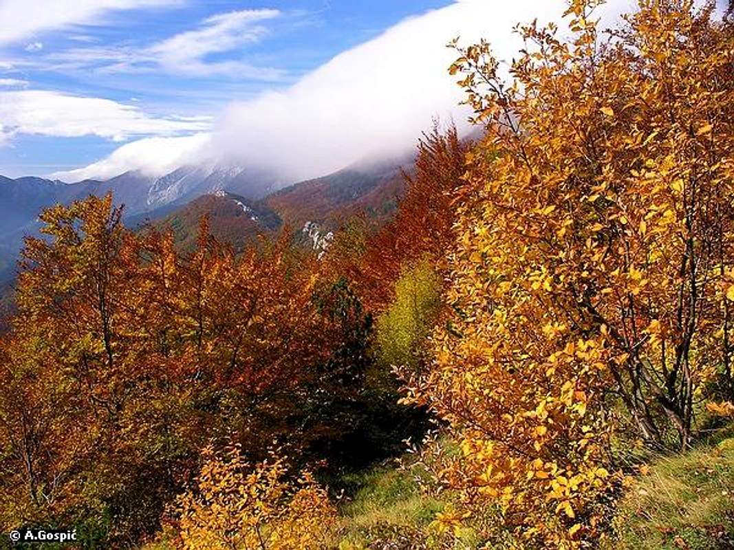
Vlaski Grad pass (1280m)
Vlaski Grad (1375m) is large, beautifully shaped cone or pyramid, depending of observing location. It is placed north of Jerkovac massif but connected to it over the nameless but quite deep pass (1162m). On both sides are deep valleys which separate them further. On the east is VlaskoGradska Draga, side valley of Mala Paklenica. On the east is shallower Kosjerica, side valley of Orljaca. On the north is Vlaski Grad (1280m) pass over which it is connected with highest peaks group and grassy slopes of Veliki Stirovac below Sveto Brdo (1751m). Some 20m below the pass, on Paklenica side, Vlaski Grad (1260m) refuge is placed. From the pass marks climb towards the summit steeply, needing some 20mins to ascent. View from the summit is fantastic, most beautiful of all the peaks in mid Paklenica area. During last decade, since Vlaski Grad refuge stands below the peak, this has become very popular area while before the 90’s war it was unmarked very rarely visited. Most hikers which know Velebit well agree that Vlaski Grad refuge is most beautifully located object on whole Velebit and has most beautiful view.
 |
 |
 |
 |
 |
Flora
Rich flora was one of main reasons to declare Paklenica a NP. 800 plants are represented inside the borders of the park while vegetations zones change from Mediterranean to sub Alpine. In Paklenica there are 40 species, mostly flowers, which are endemic to Velebit or Dinaric Alps. Forest is one of the trademarks of Paklenica so lets mention most important species.
Complexes of Beech (Bukva - Fagus Silvatica) forest are largest on seaboard side of Velebit and are especially beautiful in upper Velika & Mala Paklenica valleys. In the valleys beech trees are straight and up to 30m high while on their highest habitats, above 1500m, they are stunted, only up to 2m high and look more like bushes (for example on ridge of Viserujna) with branches that are so interlaced making it impassable to go through. It is interesting that in both Paklenica valleys beech appears very low, at about 350m, which is very unusual for seaboard side of Velebit but that shows how both valleys are influenced by colder climate which descents from higher areas. The only other place where beech descents that low is in Senjska Draga below Vratnik pass on North Velebit.
In both valleys beech is on many places mixed with Maple (Javor) (mostly Bijeli Javor (white maple) - Acer Pseudoplatanus).
Next most important tree is Pine (Bor), especially Crni Bor (black pine) - Pinus Nigra) whose complexes in Paklenica, especially on Strazbenica – Rujno – Veliki Golic area are largest on Velebit. Also large black pine complexes are on Veliko Mocilo – Crni vrh – Borovnik & Pod Planom areas.
Highest vegetation zone, between 1400-1750m, belongs to grass and Dwarf Pine (Klekovina - Mugo Pine), which is up to 2m high and forms large complexes in Vaganski Vrh – Sveto Brdo group, which are almost impassable.
Now lets descent back to lower parts of Paklenica where rock is predominant feature. This is lowest vegetation zone, spreading from 0 up to 1000m on spots and mostly belongs to:
~ Oak (Hrast - Quercus Pubescens)
~ Klen (Acer Campestre) and other types of Maple (Javor) (like Javor Gluhac - Acer Obtusatum and Maklen - Acer Monspessulanum)
~ Hornbeam (Grab) is represented with 3 sorts (Obicni (common) - Carpinus Belutus, Bijeli (white) - Carpinus Orientalis & Crni (black) - Ostrya Carpinifolia)
~ Ash (Jasen) is represented with 2 sorts (Bijeli (white) – Fraxinus Excelsior & Crni (black) – Fraxinus Ornus)
 |
 |
 |
 |
 |
Fauna
Like with Flora, Paklenica area is rich with Fauna too. For no particular reason lets mention mammals first, which are with 47 species well represented. Biggest of predators is Bear (Medvjed). It is highly unlike to stumble upon one but its footprints in snow can be frequently seen in deeper forests of Paklenica, sometimes even close to Paklenica hut. Then come Wolf (Vuk) and Lynx (Ris). If you hear grunting in the forests of Paklenica know that is Boar (Vepar). On high grassy plateaus one can frequently see their work as they are always trying to keep shallow soil layer ploughed out. If rocks are rolling down scree slopes it is most probably that Chamois (Divokoza) was happily jumping somewhere near. Deer (Jelen) is much harder to spot while frightened Rabbit (Zec) is not.
212 species of Birds (Ptice) have been recorded. 97 species are permanently nesting in Paklenica area providing nice music along the routes. 8 species are birds of pray which are nesting in cliffs of Velika Paklenica & Mala Paklenica canyons. All of them are rare, endangered and protected by law. Their Paklenica population makes 10% of all Croatian vultures. Therefore climbing in Mala Paklenica is forbidden. Most important of them is Griffon Vulture (Bjeloglavi Sup). With wing span of close to 3m Bjeloglavi Sup is biggest European vulture and bird in general. Unfortunately it disappeared from Paklenica lately and was last spotted at the beginning of millennium. Reason for that is dying of cattle breeding in the area. 50 years ago, while hundreds of thousands of cattle were wandering around, Velebit was oasis for birds of pray and vultures. Today, when people are mostly devoted to tourism, food is almost gone and so are they. There are some plans to bring sheep’s and goat’s back to Velebit pastures just for this reasons. With them or not hopefully Griffon Vulture will be spotted again flying proudly around the cliffs of Paklenica canyons.
Peregrine Falcon (Sivi Sokol) is also bird of pray. When hunting it can drop from sky speeding up to crazy 270km/h which makes it fastest Croatian bird.
Short-toed Eagle (Zmijar) is also nesting in cliffs of both Paklenica canyons. Its main food are snakes and it can be noticed while floating in the air around cliffs in search for food.
In group of 31 amphibians and reptiles living in Paklenica 12 are snakes. Nose-horned Viper & Orsini Viper are venomous but they will bite only if attacked. Biggest chance to meet them is at spring and summer.
You’ll also notice many butterflies flying around. With 82 species they are well represented in Paklenica as are on whole Velebit.
 |
Climbing
Canyon of Velika Paklenica is Croatian climbing Mecca and goal for many European climbers. While high Alpine walls are under snow climbing here is possible year round. Because of canyons position by the sea snow is not very frequent. History of climbing in Paklenica began in 1938 when Dragutin Brahm from Zagreb attempted to climb Anica Kuk (712m) but he died. Real era of climbing begins in 1960’s, especially 70’s and 80’s.
Anica Kuk (712m) with its monumental 400m high NW face is trademark of Paklenica climbing and its special chapter. Toughest Paklenica and Croatian routes have been climbed in its face. Of 120 routes toughest is Brid Klina (Edge of Peg) with difficulty of 8a! It contains 300m high completely overhanging section with smooth cliffs. It is interesting to note that first ascent via Brid Klina in 1970’s lasted 8 days! Anica Kuk was first climbed in 1940 by Breovacki & Dragman when they completed Brahm’s route where he died 2 years ago. In 80’s, when free climbing era began, Slovenian Franc Knez opened 16 new routes alone in Anica Kuk. First repetition of Brid Klina happened only in 1982. In 1990’s new modern routes were equipped with pitons. New routes in Anica Kuk were opened by climbers from Croatia, Slovenia, Italy, Austria, Germany, Switzerland & England. Some of the best known routes in are (name / height / grade):
~ Velebitaski / 350m / 6a+
~ Mosoraski / 350m / 5c
~ Klin / 350m / 6c+
~ Enigma / 190m / 7b+
~ Vila Velebita / 320m / 7b+
~ Waterworld / 350m / 7b
~ El Condor Pasa / 350m / 7a
~ Welcome / 350m / 7b+
~ Kaurismakis Mistake / 350m / 7a+
~ Alan Fjord (yes, not Ford) / 350m / 7c and so on.
Today in the cliffs of Velika Paklenica there are 1000 routes which are suitable for novice, which are training, to experts. In Velika Paklenica climbing is allowed on eastern side of the canyon till Anica Kuk while on the western side till Manita Pecina cave. Because of protection climbing in Mala Paklenica is forbidden. On 1st May there is traditional gathering of climbers from all over Europe in Velika Paklenica which lasts till 4th May. Big Wall Speed Climbing competition is held then. More info about climbing find on Paklenica National Park site.
 |
 |
 |
 |
 |
Hike Advices
Large network of marked paths gives numerous combinations. In central area of Paklenica, without highest peaks of Velebit, most interesting are of course both Paklenica canyons/valleys and peaks/cliffs above them. Two main routes through canyons/valleys; Velika Paklenica route & Mala Paklenica route are described on Sveto Brdo (1751m) page as its approach. On this page described are side routes which lead towards the peaks above both Paklenica canyons/valleys. Some of them can be combined with highest peaks of Velebit, like Vlaski Grad with Sveto Brdo and even with Crni Vrh. Veliki Golic can be combined with Viserujna or Vaganski Vrh or with both.
Vlaski Grad (1375m) is too close to Sveto Brdo (1751m) so it would be senseless not to combine them if one is your goal. For hike advices check Sveto Brdo page.
For other combinations of central part of Paklenica with highest peaks check Hike Advices on Vaganski Vrh (1757m) & Liburnija (1710m) pages.
Here is one beautiful combination if you are avoiding highest peaks. On the 1st day from Velika Paklenica climb Vidakov Kuk peak and continue towards Veliki Golic peak. Descent via Mozak ridge to Paklenica hut where you will sleep over. On the 2nd day climb Crni Vrh peak via either Malo Mocilo or Klimenta. From the summit descent to Veliko Mocilo and continue to the coast via Mala Paklenica. This way you get to see both canyons and 3 beautiful viewpoints.
 |
 |
 |
 |
Getting There
Starigrad Paklenica town is center of this part of Velebit coast and inseparable from Paklenica NP, where is its management.
By Plane
Closest airport is in Zadar, 45 km away. There are no international flights to Zadar (except charter flights during summer season) so you have to go over Zagreb international airport. There are everyday flights from Zagreb to Zadar. Find more info about flights on official site of Croatia Airlines
By Bus
There are numerous bus lines from Zagreb to Zadar each day, almost every half hour. The only problem is in the fact that there is no direct bus to Starigrad Paklenica from Zagreb. Some lines go via highway some use road via Gracac. Those that go via highway don’t stop on Maslenicki Most bridge location so from Zadar you have to take bus back towards Rijeka. Those that go via Gracac stop on Maslenicki Most bridge. You can get off there and wait for the bus from Zadar towards Rijeka or you can hitch-hike to Starigrad Paklenica, which is 15 km from here.
Detailed bus timetables from Zagreb to Zadar you can find at Zagreb bus station site.
By Train
Train is not a good option if you are coming from Zagreb. It travels longer than bus and you have to change the train in Knin towards Zadar and then take a bus to Starigrad Paklenica. Train timetables can be found on Croatian railways site.
By Car
The best way is to come by car. There are two main directions to come to this area, from Rijeka or Zagreb.
From Rijeka, along the coast
This route is suitable if you are coming from western Europe, via Trieste (Italy).
Trieste - Rijeka 70 km
Rijeka - Starigrad Paklenica 180 km
From Zagreb
This road is suitable if you are coming from eastern or central Europe via Ljubljana (Slovenia), Maribor (Slovenia) or Budapest (Hungary).
Ljubljana - Zagreb 138 km, Maribor - Zagreb 113 km, Budapest - Zagreb 347 km
Zagreb - Starigrad Paklenica (via Plitvice and highway) 250 km
From Zadar
Zadar – Starigrad Paklenica 45km
Look for current road conditions in Croatia on the page of Croatian Automobile Club (HAK)
 |
Maps
You can buy mountaineering map at the entrance into Velika Paklenica or in the Paklenica hut. Some more detailed maps would be posted soon, as soon as I make them.
For Paklenica area overview see this map submitted to Sveto Brdo page. For even wider area with approaching roads see this map which is also posted on Sveto Brdo page.
When To Climb
Find out more about Velebit climate on Velebit main page. It is easy to say that one can visit Paklenica year round but its tough to describe conditions because in Paklenica there are so many climates which are with altitude changing from Mediterranean to Alpine. Difference in temperature between entrance on the coast and peaks is at least 15°C so while on the coast it can be mild up there can be winter.
Winter: snow which remains on ground is rare occurrence in the canyons of both Paklenica valleys but in winter it quite often falls carried by Bura wind, which is most dangerous weather factor. In the area where Paklenica hut is placed snow is more often guest. If you are visiting highest peaks described on this page, not to mention highest peaks of the mountain, crampons are necessary because of often rock hard snow on northern slopes.
Spring: if we relate its beginning with appearing of the leafs on trees then spring begins by mid April on the coast. By 1st May greenery reaches Paklenica hut. By May 20th usually trees turn green at highest altitudes while grass at the beginning of June. Mid May is one of most beautiful times in year to visit central part of Paklenica because of amazing fluorescent greenery.
Summer: lasts in lower parts from June to September with narrowing window as you go higher. In July and August it can be true hell at the entrances and in canyons, with temperatures that can exceed 40°C. Starigrad Paklenica on the coast, in front of Velika Paklenica, is together with Knin town, warmest in Croatia. Deeper in the valleys is milder and there is plenty of shadow in forests. Higher is the valley where there is always water one can refresh in few deeper pools.
Autumn: in this period most beautiful is October when colors are fantastic, especially in higher parts of the valleys where beech is mixed with maple.
 |
 |
Mountain Conditions
Conditions on Velebit are very well known thanks to Zavizan meteo station, which is observing weather since 1953. On WeatherOnline & DHMZ (Croatian Meteorological and Hydrological Association) sites you can find current data for Zavizan and on WeatherOnline even forecast. Also you can check forecasts for Zadar city on both sites because it is close to Velebit. On the coast in front of Paklenica temperatures are similar to Zadar.
Here are the links where you can find out about the current weather on Velebit (Zavizan) and forecast for Croatia:
WeatherOnline:
WeatherOnline home page
Croatia at WeatherOnline,
Zavizan at WeatherOnline
Croatian Meteorological and Hydrological Association (DHMZ):
DHMZ home page
DHMZ Forecast page
DHMZ 7 Day Forecast for Croatian cities and places World wide, including Zadar
Current Weather Conditions in Croatia including Zavizan and Zadar. Zavizan reports weather between 04-14h & 19-21h. In summer it is 1h+.
Snow Depth's in Croatia
Objects

Paklenica hut
Dom u Paklenici (480m) (Paklenica hut) is placed in the beech forest at the point where Upper and Lower Velika Paklenica valleys. There is plenty of water here all year, which makes it perfect base for dozens daily hikes. Above the hut there is pool in which you can swim in summer. The hut produces its own electricity from the small generator that is powered by water from the creek. There is also satellite phone here, which uses Croatian Telecom calling cards, which you can by in every tobacco shop or gas station (there is no cell phone signal here because mountains are all around). The hut itself has 40 beds in 5 rooms and is supplied with drinks and partially with food, which means it is better to take your own food but if you don't you won't stay hungry. During the season (June to October) and holidays it’s open constantly. The rest of the time it is open from Friday to Sunday evenings. Valter Morovic, from Zadar, manages the hut.

Vlaski Grad refuge
Vlaski Grad (1260m) refuge is placed some 20m below the Vlaski Grad pass (1280m) and below Vlaski Grad (1375m) peak. It has up to 20 persons capacity, sleeping bag is a must. There is also furnace in the refuge. From it is beautiful view towards both upper Paklenica valleys, main ridge of Velebit, sea and islands. Water cistern is above the refuge. It is filled by weak water source which is not active in summer.

Ivine Vodice refuge
Ivine Vodice (1250m) refuge stands by the edge of a small meadow, on the steep forested slopes above upper Velika and Mala Paklenica valleys, some 2.45h from Paklenica hut. From it is another hour to Vlaski grad refuge. It has up to 15 persons capacity, sleeping bag is a must. There is also furnace in the refuge. 10m from the refuge is water cistern (small well). 5mins below the refuge is one of water sources that power Velika Paklenica creek. It is not active in dry period.
Camping & Accommodation
In Paklenica NP camping is forbidden.
If you want to camp on the coast before or after visiting Paklenica there are dozens of camps on the coast in the Starigrad Paklenica and Seline. Many are concentrated around the entrance into Velika Paklenica. Also there are many hotels and apartments in both places. More info on accommodations & camping you can find on Starigrad Paklenica Riviera site or Adriatica.net, online searching & booking site for Croatian coast and wider.
Red Tape
Whole area is NP but the only spot where entrance-ticket is charged is at the entrance to Velika Paklenica canyon, which is 30 Kuna (4 Euro or 5 Dollars). One ticket is worth for two entrances or one entrance with visit to labyrinth bunker in cliffs of Velika Paklenica or Manita Pecina cave. In Velika Paklenica there is no extra fee on parking. If parking inside the canyon is full they will tell you on the entrance to leave the car there. In that case minibus will take you there without extra fee. You don’t have to pay if you are accessing.
More information about prices and various packages can be found on Paklenica National Park site.
Other Velebit pages on SummitPost
~ Velebit massif, main page
~ Zavizan area, North Velebit (Mali Rajinac (1699m) highest peak on the page)
~ Rozanski Kukovi group, North Velebit (Gromovaca (1676m) & Vratarski Kuk (1676m) highest peaks on the page)
~ Alancic / Rozanski Vrh / Seravski Vrh, North Velebit (Goli Vrh (1670m) highest peak on the page)
~ Veliki Kozjak (1629m), North Velebit
~ Satorina (1624m), Mid Velebit (including whole area between it and Alan pass)
~ Stap area, South Velebit, (Debeli Kuk (1269m) highest peak on the page)
~ Visocica (1619m), South Velebit
~ Bojin Kuk (1110m), South Velebit
~ Viserujna (1632m) & Rujno, South Velebit
~ Vaganski vrh (1757m), South Velebit (highest peak of Velebit)
~ Liburnija (1710m), South Velebit
~ Sveto Brdo (1751m), South Velebit
~ Tulove Grede (1120m), SE Velebit
~ Crnopac (1404m), SE Velebit
Note: Text on this and pages above is copyrighted and cannot be used in any kind of publications.
visentin - Jun 2, 2009 2:48 am - Voted 10/10
canyon ?Wouldn't this page be better as a canyon ? Otherwise, congratulations for the magnificent content !