
|
|
Mountain/Rock |
|---|---|
|
|
70.84000°N / 68.65°W |
|
|
5305 ft / 1617 m |
|
|
Overview
This is the last page I will be putting up from Baffin Island as I hope that I have shed some light on the great peaks that exist in the far north of my country.
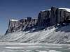
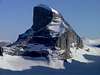
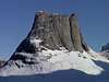
Great Sail Peak rises 1617m and like its neighbour (Polar Sun Spire) is located near the Sam Ford Inlet, in nearby Stewart Valley. The peak is reminiscent of Castle Peak in the Canadian Rockies with sheer walls leading up to a relatively flat and broad summit plateau… though Great Sail Peak is the more dramatic of the two by quite a bit. This peak was formed when a glacier from the last ice age retreated. The rock is a mix of granite and gneiss and is relatively young geologically… with very few cracks.
The main feature of Great Sail Peak is its NW face, which is a sheer 1150m wall that beckons to climbers and base jumpers from all around the world. There are numerous 500 meter faces all along this peak buts it’s most assuredly the NW wall which draws the most attention and rightly so.
The peak is located to the north and to the east of Polar Sun Spire and is the lone ‘big wall’ in its region… if one excludes numerous walls that range from 500-700 meters… here unlike anywhere else on earth that is surprisingly true. Photographer and Baffin Island expert Eugene Fisher did an expose on the Sam Ford area in 1994, and he was quoted as stating that “if Yosemite Valley were located along one of these Inlets it would count as a minor side fjord”… This is not meant to insult Yosemite in any way but rather to draw attention to the sheer magnitude of these walls. They are most assuredly one of a kind.
Great Sail Peak was first climbed in 1998 by a National Geographic team comprised of 6 members. The team leader on this climb was the same man who led the first climb up Polar Sun Spire, Mark Synnott. The other three climbers were Jared Ogden, the late Alex Lowe and Greg Child. The other two members were cameramen John Catto and Gord Wiltsie. This article appeared in January 1999 issue of National Geographic.
The climb took 23 days and while not as grueling as the first ascent up Polar Sun Spire it was still VERY demanding. The climb was broken up into two sections: The first section involved working their way up to a ledge about 425m up. From there was a final push up an untested 725m wall to the top. All tolled the northwest wall is 1150m high and is one of the biggest cliff faces in the world.
Since then there have been very few successful climbs up Great Sail Peak via Great Sail Wall; though of note a Russian team pioneered a new route up in 2002. From the summit several of the climbers did a base jump... the other mainstay amongst this regions aficionados. There are 10 major walls that base jumpers frequently jump from… most prefer a trip by helicopter to the top rather than climbing.
***All pics courtesy of Alexander Ruchkin (www.adventuretravel.ru/eng), Torkel Roisli (headwall.com) and Brad Barlage.
 |  |  |  |  |
Getting There
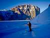
Again like Barbeau peak and the peaks from Auyuittuq this is the most difficult part of the journey... and of course the most expensive. Flights originate in Montreal and may require a stopover in Pangnirtung or Iqaluit before continuing onwards up to Clyde River. Clyde River is about 400- 450km north of Auyuittuq and Pangnirtung where the Nunavut Parks headquarters is located.
From Clyde River the journey is either made by sled or boat into Sam Ford Inlet depending on how frozen the ocean is around Clyde River. The journey can be done in 2 long days or 3-4 days... as per usual entirely dependent on mother nature.
From Polar Sun Spire, Great Sail Peak is located to the east and the north. One needs to travel across the Inlet heading north and then when the Inlet moves east-west simply head west for 6-10km until you come face to face with mighty Great Sail Peak and Great Sail Wall (the NW face).
Much like Polar Sun Spire, Great Sail Peak via the Great Sail Wall has been climbed only a handful of times so there is very little information out there. The best time to climb is a six to seven week window which stretches from the second half of May through to the end of June.
Once in Clyde River, Quillukkut Guides and Outfitters are the only agency that can outfit a group for the needs of an expedition. The Outfitter is run by local Inuit (a husband and wife) who are more than eager to help in any way they can and will go well beyond what is called for to make visitors feel welcome.
 |  |  |  |  |
Red Tape
Again the most difficult part is simply getting there. As far as I know there is no permits required to visit the area... the $5000 investment most will already be making is investment enough I am sure.
The only real time to climb is duing the latter half of May through to the middle of July. I am sure it is possible to dog sled through the area in April or May. The weather though is far different than it is in later in Spring and during the first few weeks of summer. In April temperatures can average between -15 and -25 celsius... quite inhospitable...while in June and July it is somewhat inviting with daytime highs approaching 10-12.
 |
When To Climb
The only time to really climb is from mid May to mid July before the pack ice breaks up... becasue after that the fjords and inlets become impassable.
It is perhaps possible to climb some of the smaller walls earlier in the spring but the cold, the wind and the storms would make this more of a herculean taks... battling the Spire itself is difficult enough without factoring in the weather
 |  |  |  |
Camping
Camping is allowed... there are no specific spots allotted its simply pickwhatever spot you think is best and settle in for the night. Be careful of camping directly beneath any of the cliffs as like the peaks in Auyuittuq large rock falls are a regular daily event.
Again always follow the rule of packing out what you bring in as the area is a remarkably unspoiled Arctic environment
 |
Mountain Conditions
For weather conditions you can check two places. Firstly as always the www.theweathernetwork.com will have hourly updates on the local conditions plus a five day forecast.
You can also check www.wunderground.com/global/stations/71090.html which seems to provide even more accurate up to the minute details. Other than that the Outfitters will probaby be able to provide you with an idea as to waht to expect weather wise during your visit.
Of Interest
As mentioned on the Polar Sun Spire page there are many other big walls in the region. As one can see from the photos there is limitless climbing potential.
These are some of the more popular ones:
Walker Citadel or Walker Spire is a huge 1200m wall.
Kiguti Peak is a very overhung, (huge yet again) 1000m wall.
Chinese wall is similar in shape to Great Sail with 900-1000m cliff faces
The Beak is a very overhung 700m wall
The Ship’s Prow is a very overhung 600m wall
The Fin is a 750m wall.
Ottawa Peak has a 1100m wall.
Mt. Beluga has a 900m wall.
Scott Wall has a 1000m face.
 |