
-
 13499 Hits
-
 85.36% Score
-
 20 Votes
|
|
Mountain/Rock |
|---|---|
|
|
46.54400°N / 10.85890°E |
|
|
10685 ft / 3257 m |
|
|
Overview
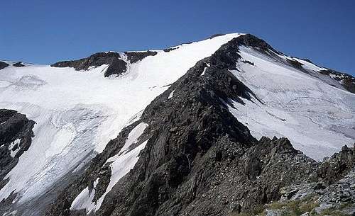 Hasenöhrl summit from Blaue Schneid Hasenöhrl summit from Blaue Schneid |
Hasenöhrl / L'Orecchia di Lepre (Hare’s Ear) is the easternmost summit of the Ortler / Ortles Group that actually is still covered with glaciers. It is located in the triangle between the deep Martell-, Ulten- and Vinschgau Valleys (Val Martello, Val d'Ultimo, Val Venosta). It is rather popular since the ascent routes don’t pose too many difficulties and due to its solitary location it offers great views towards the Ötztal Alps (Weisskugel and Similaun) the central Ortler / Ortles Group Group, the western Dolomites as well as the Brenta-, Presanella- and Adamello Groups.
 |  |  |
There are several routes to the summit but all of them are rather long and cover a difference in altitude of roughly 1300 – 1500m. At the beginning a moderate climb through larch forests and over meadows they fast become a prolonged scramble which, however, never exceeds grade I. From a side summit, Blaue Schneid / Cresta Azura (3000m) the final ascent leads over the rocky north ridge. The flanks at both sides of this ridge are covered by glaciers, Hasenohrferner und Kuppelwieser Ferner. The ridge itself is snow free.
 |  |  |
One of the attractions of the northern route to the summit is an old irrigation channel (locally called Waal), created in 1868 to collect the glacier water and transport it to the vineyards and fruit plantation of the Vinschgau valley floor. The glaciers have so far retreated, however, that this irrigation system has not been in operation for the better part of the last century. The hike along this Waal is one of the most beautiful parts of the ascent. you just walk along at the same altitude and enjoy the views to the valley floor 2000m below.
Getting There
  |
The best trailhead for this mountain is at Tarsch / Tarres on the southern slopes of Hasenöhrl. There is a lift that takes you to Tarscher Alm / Malga di Tarres at 1940m. To reach Tarsch / Tarres the following directions apply:
From Italy
- Take the Brenner motorway A22 which you leave at Bozen / Bolzano south.
- Take SS38 (Vinschgauer Staatsstrasse) northwards towards Meran /Merano).
- The road follows the Etsch / Adige Valley into Vinschgau / Val Venosta.
- Follow the road westwards until you reach Laatsch / Laces.
- Drive into the village (the main road passes it) and follow the signs to Tarsch / Tarres turning left on a side street. This leads you through apple orchards towards the village of Tarsch and on to the bottom station of the Tarsch ski lift (operated also in summer).
From Austria
- Take Inntalautobahn (Motorway A12) westward from Innsbruck to Landeck.
- At Landeck turn onto road B180 which winds its way upwards the upper Inn valley towards Nauders.
- Between Nauders and Reschen /Résia you cross the border and are directly on the shore of Reschensee / Lago di Résia.
- Follow the main road down torards Laatsch / Laces from where you go on the road to Tarsch / Tarres, this time turning right.
From Switzerland
- Take motorway A3 from Zürich or E43 from Bregenz southwards in the direction of Chur.
- Shortly after the motorways meet turn off onto road B28, direction Davos.
- After Davos at Susch the road splits (B27 / B28).
- You can take either roads - the southern one (28) leads you over Ofenpass (Passo dal Fuorn) into Vinschgau (there take the main road downwards (east)), the northern one (27) goes to the swiss-austrian border near Pfunds where you turn southwards again on B180 and head for Nauders, Reschen and on through the whole Vinschgau valley until you reach Laatsch / Laces.
Alternative
- From Meran you can drive to the southwest into Ultental / Val Ultimo.
- At Zoggeler See /Lago di Zoccole turn right in the direction of Kuppelwieser Alm.
- Get to the end of this valley where an ascent route to Tarscher Pass / Passo di Tarres starts. From the pass the ascent follows the same trail as the one from Tarsch / Tarres.
Red Tape
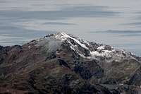
 Hasenöhrl and Flimspitze seen across Vinschgau / Val Venosta
The Hasenöhrl summit belongs to the natural park Stilfser Joch / Parco Naturale dello Stelvio. See the following link for more information:
When To Climb
 Hasenöhrl seen from the north
Hasenöhrl can be climbed all year round though summer and autumn are the regular hiking seasons. The whole summit region, however, is a good target for ski tours in winter.
Accommodation
Mountain Conditions
Maps & Books
Maps
- Vinschgau / Val Venosta
Kompass Map WK52
1:50000
ISBN: 978-3-85491-058-9
- VAL MARTELLO-SILANDRO-LACES
Tabacco Map 045
1:25000
ISBN: 978-8883150661
- VAL D´ULTIMO / ULTENTAL
Tabacco Map 042
1:25000
ISBN: 978-8883150562
Books
- Vinschgau
Rother Wanderführer
Rother Verlag
ISBN: 978-3-7633-4204-1
- Vinschgau / Ortlergruppe
Kompass Wanderbuch 950
Kompass Verlag
ISBN: 3-87051-404-3
- Ortleralpen
P. Holl
Alpenvereinsführer
Rother Verlag
ISBN: 3-7633-1313-3