
|
|
Mountain/Rock |
|---|---|
|
|
39.77550°N / 106.3505°W |
|
|
13419 ft / 4090 m |
|
|
Overview
Eagles Nest is one of the most spectacular mountains in Colorado. Even though the peak is rugged and scenic, it is much less climbed than the 14'ers in the area. The peak still recieves around half a dozen signatures in the register a year so it is still a quite popular ascent.
Several beautiful lakes and meadows are present on the lower slopes, and several jagged and spectacular ridges and peaks are visible from the summit. To date, Eagles Nest has one of the most spectacular summit views of the peaks that I've climbed in Colorado.
Eagles Nest is the northern-most 13,000 foot peak in the Gore Range. The Gore Range is one of the most rugged ranges in Colorado, and although popular, the peaks see relatively few visitors when compared to the extremely crowded 14'ers. The trails to the various lakes do see very heavy use in summer, but most hikers stick to the trails on the lower slopes of the peaks.
Adding to the attraction of the climb is the fact that the peak is in a wilderness area and quite a ways from the nearest road (by Colorado standards). Most climbers will need two days to complete the climb. Although possible, only those climbers in a big hurry would want to climb the peak in one day.
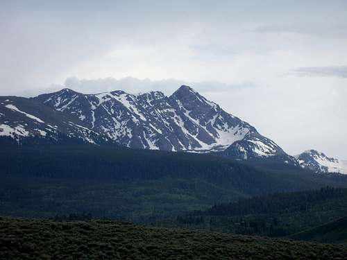 Eagles Nest from the east.
Getting There
Cataract Lake Trailhead:
From Highway 9 about 16 miles (16.7 miles from exit 205 off I-70) north of Silverthorne turn west on County Road 30 (at the south end of Green Mountain Reservoir) posted for Heeney. Follow the road 5.4 miles to County Road 1725 (Cataract Creek Road) and turn left following the road 2.3 miles to the Surprise Trailhead. Or from Kremmling, follow Highway 9 south for about 12.4 miles to the Green Mountain Reservoir. Follow County Road 30 passing along Green Mountain Reservoir and through Heeney for 5.1 miles to County Road 1725 (Cataract Creek Road) and turn right following the road 2.3 miles to the Surprise Trailhead at Lower Cataract Lake. There is a small fee for parking at the trailhead. The road is gravel, but any car should be able to make it to the trailhead. The trailhead is at 8590 feet elevation.
Elliot Ridge Trailhead:
Follow Highway 9 north of Silverthorne or south of Kremmling, to County Road 10-Spring Creek Road which branches to the west of Highway 9 between mile post 128 and 129. (This is 2.5 miles north of Green Mountain Reservoir). Follow the gravel road (County Road 10) west turning right after a short distance at a "public access" sign. Go straight at the intersection at 6.3 miles from the highway. After another 1.1 miles, turn right at the road posted for "Sheephorn Drive" and "Mahan Lake". Stay on the main track until you reach an intersection 10.4 miles from the highway (3 miles from the Sheephorn Drive sign). Stay left following the road posted for Mahan Lake. In another 1.6 miles, turn right at the fork. After another mile turn left and follow the short track to Blue Lake. This is the trailhead. The road to the trailhead is pretty rough for passenger cars. The trailhead is at 11,160 feet elevation.
Piney Lake Trailhead:
See Aaron Johnson's Getting There description posted here.
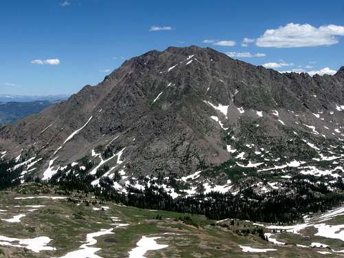
 Eagles Nest from the north.
Routes Overview
This is an overview only. See the route pages for more detail.
Cataract Lake/South Ridge Route
This route could be called the standard route up Eagles Nest. The route goes to Surprise Lake, to spectacular Upper Cataract Lake, Mirror Lake, then leaves to the trail to hike south up Cataract Creek to a small lake. From the small lake, the route climbs very steeply to ridgeline between the saddle between Eagle Nest and Mount Powell and Eagles Nest itself. From the ridgeline, the route climbs the ridge north to the summit of Eagle Nest. The summit Eagles Nest Peak is about 10 miles from the Cataract Lake (Surprise) trailhead, but it seems longer because the route is so rugged.
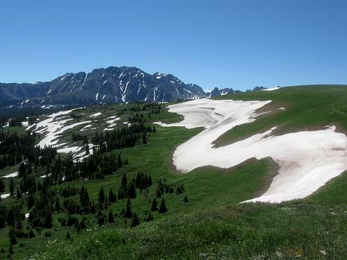
 Eagles Nest from the west. The south ridge is the ridge to the right.
Elliot Ridge Route
From the trailhead at Blue Lake, this route follows the trail along the Elliot Ridge and to point 11,952. Beyond the point, the trail descends to a saddle at 11,650 feet before climbing along the gentle ridge to the junction with the Upper Cataract Trail. From the junction, the route follows the Upper Cataract Trail to near Cataract Creek. This is where you leave the trail and the remainder of the route is the same as above on the Cataract Lake Route. The peak is about 9 miles from the Elliot Ridge Trailhead, but as mentioned, it seems longer because the last part of the route is so rugged.
 Eagles Nest from Elliot Ridge.
East Ridge Route
This is the shortest route up Eagles Nest, at least from the east side, but it is harder and more tedious than the South Ridge Route. The East Ridge is the route we took on August 11 2001, before learning that the south ridge was the standard route. It's still a good route to the peak.
The route goes to Surprise Lake and shortly after climbs to the east ridge. There are several gendarmes which form obstacles before reaching the summit.
North Ridge Route
I haven't done it, but have been told that the North Ridge can be climbed from Cataract Lake. It is class 4 and might be the quickest way to the summit of Eagles Nest.
Piney Lake Route
I have not climbed this route. Credit should go to Jimmyjay who added most info for this route and posted this as an addition/correction.
Head as for climbing the standard route on Mount Powell from Piney Lake. This is posted HERE and is from Aaron Johnson. From the 11,200 basin SW of Powell, instead of heading to Kneeknocker Col, head North to 12060 Grappel Pass. Descend north, losing as little elevation as possible until an ascent can be made to the saddle on the ridge between Eagles Nest and Powell. Head cross-country to the east along the steep and rocky slope up to the saddle at 12,800 feet. The route is really steep near the saddle. The saddle is about 0.7 miles from the small lake with 1800 feet elevation gain. From the saddle, follow the rugged ridge 0.6 miles to the summit of Eagles Nest Peak. There are several little summits/pinnacles along the rugged ridge and the middle summit is the highest.
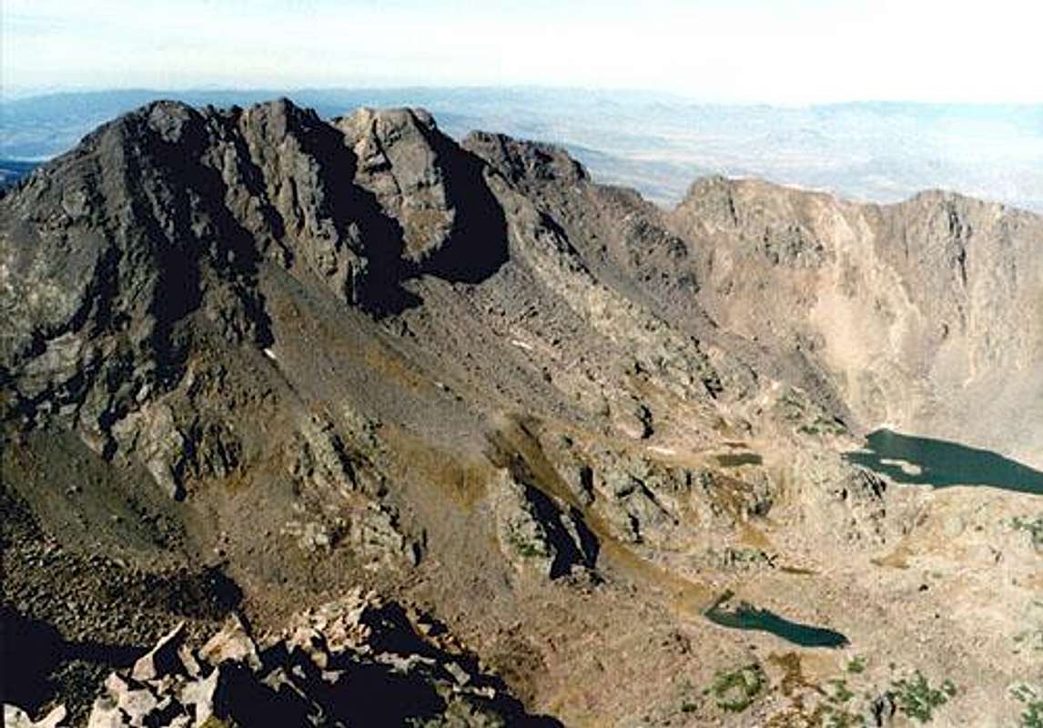 Eagles Nest from the south.
Time Needed for Climb
Most climbers/hikers will need one in a half to two days to complete the climb from any route, at least from the west side. Only those who enjoy punishment will think of climbing this peak in one day! The Piney Lake Route is said to be shorter and more doable in one long day. The east ridge is reasonable in a very long day.
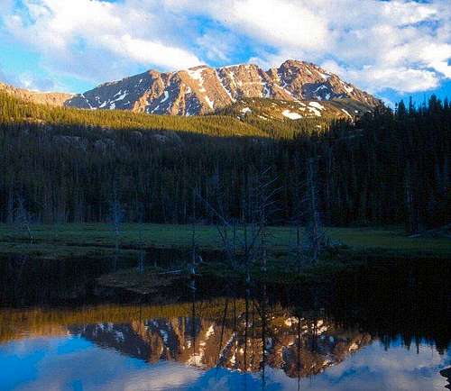 this was taken at a small pond near Eaglesmere Lakes.
Red Tape
No permits are required for climbing the peak. Parking at the trailhead at Cataract Lake requires a small fee. The peak and surrounding areas are located in the Eagles Nest Wilderness Area and all wilderness regulations apply.
When To Climb
July through September is the normal season for climbing.
This would be a very challenging climb in winter, and avalanche danger is high on this mountain. The road to the Elliot Ridge Trailhead is not plowed in winter, but the road to Lower Cataract Lake is usually plowed to close to the trailhead.
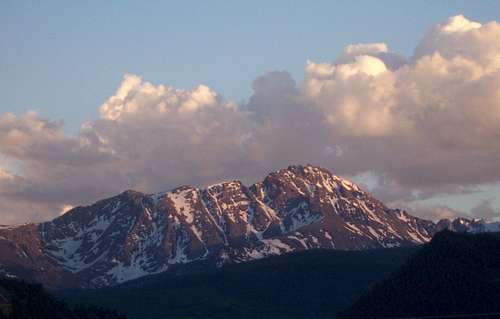
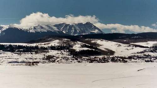 Eagles Nest in winter, as seem from the east.
Camping
Cataract Lake Route:
There is a campground at Lower Cataract Lake, as well as several others around Green Mountain Reservoir. Contact the Dillon District of Arapahoe National Forest, Kremmling Office at 970-724-9004 for information on these campgrounds.
There are many good campsites along the trail all the way to the pond at 11,050 feet. Campsites around Surprise Lake, Cataract Lake, and Mirror Lake tend to see over use in the summer time, so if you want solitude camp higher along Cataract Creek.
Elliot Ridge Route:
There are several informal campsites along the road to the trailhead after reaching public land, including a site right at the trailhead.
There are no really good campsites along hike along the Elliot Ridge, though there are a few OK ones available, and with great views (but high winds). It's best to camp after reaching Cataract Creek.
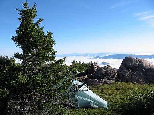 Camping on the Elliot Ridge.
Mountain Conditions
NORTHERN GORE RANGE WEATHER FORECAST
For more information and trail conditions call the Arapahoe National Forest, Dillon District, Kremmling Station at 970-724-9004.