
-
 14179 Hits
-
 83.85% Score
-
 18 Votes
|
|
Mountain/Rock |
|---|---|
|
|
42.94307°S / 171.53600°E |
|
|
6013 ft / 1833 m |
|
|
Overview
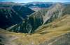
In the beautiful region of the Arthur’s Pass National Park there is a mountain with a very dramatic name: Avalanche Peak. Despite its rather dangerous name, this mountain offers its visitors a terrific one-day hike in the wonderful environment of the Southern Alps.
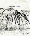
There are basically two routes to choose from Arthur’s Pass. Both routes are following some relatively easy tracks which are marked with big yellow stakes all the way to the summit.
 |  |  |
Getting There
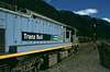
Although reachable by bus or car the most recommended and scenic means of transport to get to Arthur’s Pass is by the Tranzalpine train. This train, similar to the Glacier Express in Switzerland, offers comfortable panoramic wagons and takes you through spectacular gorges and river valleys, across the Southern Alps of New Zealand.
The train starts in Christchurch at the Pacific Ocean and goes north through the Alps all the way to Greymouth, situated by the Tasman Sea on the other side of the country.
 |  |  |  |
Routes
Both of the normal routes are located on the east flank and have the small settlement at Arthur’s Pass at 730 m as the starting point. Before you head for the track, do pop in for a short visit at the DOC Visitors Centre (Department of Conservation) where you can get an update of the weather forecast, get a map and even leave a note behind about your intended hike in case you choose to go solo.
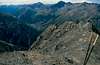
A / The Avalanche Peak Track is the more steeper one. You pick up the track just behind the DOC centre, crossing a small bridge over the Avalanche Creek. The track takes you through the vegetation on a steep hillside passing some nice waterfalls. The bushline is left at 1,200 m. Up here you follow the ridge straight to the peak.
On top of the summit you have a great view of the neighbouring Mount Rolleston (2, 275 m) with the Crow Glacier which raises majestically, the Mount Bealey on the opposite side and the Bealey valley.
Expect around 1,5 hours time to the bush line and 1,5-2 hours from the bush line to the summit.
B / The Scott’s Track is less steep and is sign posted on the main road opposite the Devils Punchbowl waterfall. The track goes in zigzags through the bush line and here, as well as on the Avalanche Peak track, the route is marked with big sticks towards the summit, which are
clearly seen when leaving the bushes.
An ideal roundtrip is of course to climb via the Avalanche Peak track and return via the Scott’s Track. The crossroad is around 15 min below the summit at around 1,680 m.)
Camping
The small settlement at Arthur’s Pass is situated around four kilometres east of the pass.
The Sir Arthur Dudley Dobson Youth Hostel is a perfect place to stay. There also exists a youth hostel and of course the Visitors centre as mentioned above.
Obviously the Avalanche Peak is nice one-day hike. The Tranzalpine morning departure from Christchurch at 08.15 am arrives at Arthur’s Pass at 10.42 am (timetable April 2004.)
Useful tips
At the DOC Visitors Centre (Department of Conservation) they sell small handy maps over the neighbouring mountains where lots of facts and suggestions are gathered.
Maps: Park map Arthur's Pass (1:100,000); Topomap K33 - Otira (1:50,000).
Check out more about New Zealand´s National parks.
mpbro - May 9, 2006 3:07 am - Voted 7/10
lat/lonDon't have an exact lat/lon, but this is roughly centered on the summit: Google map. Guess lat=-42.94 lon=171.54 would work.
mpbro - May 9, 2006 3:34 am - Voted 7/10
campingAs a general statement, NZ campervans are free to camp anywhere except where posted. There are numerous spots around town. Visitor Center would work. There's a great spot at the trailhead for the Mount Beelah track, just a bit south of the visitor center and a short distance up the road toward the police station.
rgg - Apr 8, 2011 1:03 pm - Hasn't voted
Additional routes and exact coordinatesHi Andre, In addition to the Avalanche Peak Track and Scott's Track, I know of two more routes:
chugach mtn boy - May 12, 2012 12:13 pm - Hasn't voted
OopsAndre, someone has mistakenly made this page PARENT of the Southern Alps instead of a child. As a result, the Southern Alps are a child of Avalanche and show up as a sub-range of Avalanche Peak! You can easily fix that. So could the Southern Alps page owner, but he's long gone from SP.
andre hangaard - May 13, 2012 6:26 pm - Hasn't voted
Done!Now it should be fixed! Many thanks for making me aware :-D
gimpilator - Nov 27, 2015 2:04 pm - Hasn't voted
CoordinatesPlease include the following coordinates so that this page appears on the map. Thanks! (-42.943071, 171.536003)