

-
 55980 Hits
-
 97.28% Score
-
 67 Votes
|
|
Mountain/Rock |
|---|---|
|
|
45.62040°N / 7.47585°E |
|
|
Mountaineering |
|
|
11532 ft / 3515 m |
|
|
Overview
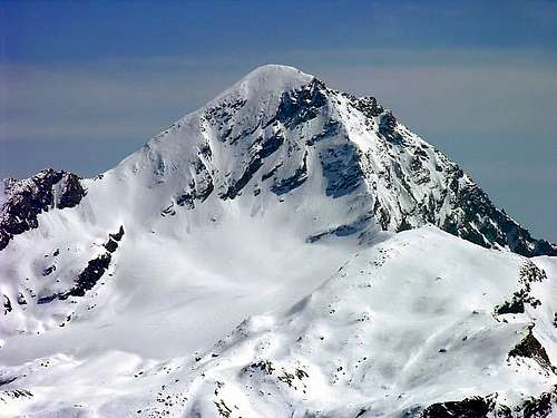
 La Punta Tersiva è una montagna piramide-sagomata ed elegante messa fra tre valli: Clavalité (verso Fènis), Urtier e Grauson (verso Cogne). Dalla sua cima è possibile ammirare una delle prospettive a 360° più attraenti dell'intero cerchio alpino, incluse tutte le montagne della Valle d'Aosta, dal Massiccio del Gran Paradiso al Gruppo del Monte Rosa. Alcuni scalatori affermano che dalla sua Vetta la vista spazia con un volo aereo dal Fiume Po (in direzione d'Oriente) insino al Mar Ligure (a Meridione). In primo piano, è di particolar interesse la prospettiva del Gruppo dell'Emilius, così come verso i Valloni della Valeille, del Bardoney e delle Acque Rosse.
Labelled panoramic view from the summit of Tersiva; an unlabelled version can be seen here
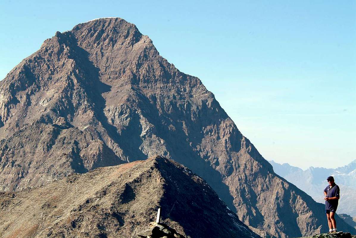
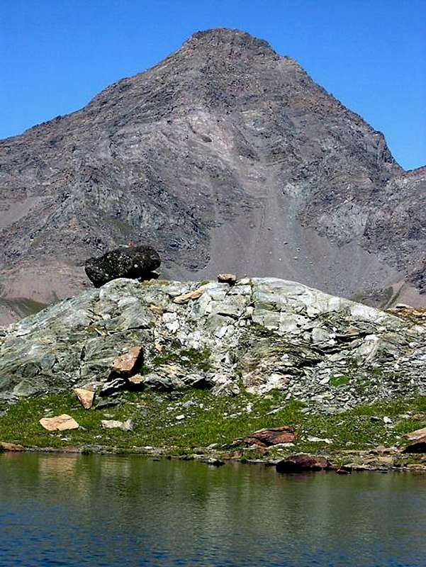
The best route to the summit is on the NNW side, along the Tessonet ridge; the other sides have to be avoided because of the poor quality of the rock. The North side is very spectacular; one can catch a glimpse of it going along the main road n°26, between the localities of Champagne and Fénis. Under the North face one can see the small Glacier de la Pointe Tersiva, that late in the summer takes on a greyish colour, because of the frequent fall of detritus from the wall; even if small, nevertheless it becomes spectacular with the first snowfalls, appearing as a tormented glacier crossed by many crevasses. At the foot of the pleasant N-W face there is the Tessonet glacier; the South side is not of any remarkable interest, since it is made up of wrecks and broken big rocks.
Il miglior percorso per la Vetta trovasi sul lato di N-NW, lungo la cresta del Tessonet; gli altri lati sono da evitarsi a causa della cattiva qualità della roccia. Il Versante Settentrionale è molto spettacolare; lo si intravvede lungo la SS.26, tra le località di Champagne e Fénis. Sotto la Faccia Nord si annovera annotandolo il piccolo Glacier de la Pointe Tersiva che in tarda estate assume un color grigiastro, a causa della caduta frequente di detriti dalla parete soprastante; pur se piccolo, ciononostante diviene spettacoloso con le prime nevicate, assumendo le sembranze di un ghiacciaietto tormentato dalla disposizione a pettine dei molti crepacci. Alla base della Parete N-O è da ammirarsi piacevolmente il Ghiacciaio del Tessonet; il lato Meridionale della montagna non è di alcun interesse straordinario, siccome è costituito esclusivamente da dirupi di rocce molto rotte.
|
||||||||||


Historical and Toponymic Notes
Famous from the beginning of the mountaineering the Point Tersiva also known anciently as Punta Doreire (* * * * you see the various small guides by Mario Aldrovandi 1930/32: "Guide of the Valley of Champorcher", "Guide of the Valley of Cogne" afterwards put together and comprehensive besides of "The Valley of the Clavalité" (pages 191/5) in "Guide of the Autonomous Region of the Valley of Aosta" Edit. S.P.E. di Carlo Fanton, Turin, December 31th 1964. In the last one the mountain is treated at page 150 in relation to the Champorcher Valley: "The name Tersiva originates from the transparency of his sky. In Val of Cogne it is also known with the name Doré, (or Dorère) for the golden aspect of which it mantles at the first daylights. I expect that it originates from the coloration of its rocks.", page 195 inherent to the Fénis/Clavalité Valley; and page 289 concerning Cogne Valley or Doré and also Dorère. On the more Western side of the Peak the new Statue of the Virgo (black) has been positioned, after that the white statue, existing up to the end of the years' 90 (in 1997 still in existence; you can see the photo of 1993), he had been object of an intrigue worthy of a thriller. He was found along the walls shattered, because of a lightning bolt, solving the mystery and so definitely putting an end to the diatribe between the mountain climbers of Fénis and those of Cogne. In this way all happily descended and mostly convinced that nobody had cheated.
 ANNOTAZIONI STORICO-TOPONOMASTICHE  |
Topographical Notes & Paths of Approaches
|
Crests & Ridges
Tersiva constitutes one of the most important peaks of that vast area, immediately South of the Gran Paradiso range, that extends just South of the Dora Baltea river crossing half Valley of Aosta among the Communes of Aymavilles and Pont Saint Martin and besides toward Southeast the whole Valley of Champorcher up to the confinements with the Region Piedmont. In this enormous zone comprehensive beautiful tops as the Emilius Mountain (3.559m), the Chain of the Great Roise (3.356m), the Point Garin (3.451m), the Mont Delà (3.139m), the Mont Glacier (3.186m), the Mount Avic (3.006m) with his Natural Park and on the opposite side over the Torrent Ayasse and to the border with the Valley of the Orco/Ceresole Reale the Rosa of the Banchi (3.164m); among all these ancient pyramids, that seen by Northeast to lower some sun damage a yearning illusion appearing as those of Egypt, the Tersiva it is second in height to the only Emilius Mountain. Nearly positioned to the center of this great area it sends his crests and it falls his walls on the Valleys of Cogne (Wide Valleys of the Urtier and the Grauson) and of Fénis/Clavalité; but his long Ridge South-southeast in direction of the two Towers and the Hill of the Pontonnet goes to also touch the Valley of Champorcher. This mountain results to be a perfect pyramid composed by five crests and as many walls; four of these crests directly climb to the Peak, while the scene or Crest South-southwest goes to join himself with the Crest South-southeast, coming from the Pontonnet Pass (2.897m), as soon as before the Top to quota 2.457m. The other crests, analyzing clockwise the mountain beginning from the Crest North-northwest or by normal, introduces these characteristics:
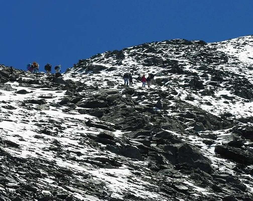
1) - Crest N-NW: it is the terminal part of the long buttress dividing watershed the Valleys of southwest Cogne and the tall Comba Tersiva in the Valley of East-northeast Fénis/Clavalité; the same one originates from the Tessonet Peak(3.266m) and, after having formed the Quotas 3.188m, 3.213m, 3.273m, 3.280m, 3.305m and 3.327m, known as Coast of the Tessonet, shortly goes down to the Tersiva Pass (3.310/2m) for then to conclude in peak with a linear slope on a trace of path, if he doesn't introduce snowy (generally July and August and, at times, also September and half October). This final line introduces today still an I wait for snowy with snowy frames in beginning of season, but thin to about forty years it was practically ago it for the whole year ( * you see various photos September 1974). Pleasant and elegant ascent rather with the snow, otherwise the crest becomes because of the deposit banal and very attractive in some lines (especially under the Tersiva Pass) and besides annoying.
One can arrive at the Tersiva Pass in three ways: a) - from the Grauson Valley: from the Village of Gimillan or, in local language "patois, Dzimillan to go up again to the Pastures ofE'closeur, Alp Pila and to the Grauson Vieux; to the alternative immediately after this old installation to leave on the left the following fork for the Lake Corona or the four Lakes of Lussert and progress instead on the right toward the Pasture of Pralognan and the following one of Ervi(e)llères. From here (you see in the detail the Routes) to climb toward the Glacier of the Tessonet edging it on the left and, on traces in the side moraine (stonemen and cairns), to reach the base of the Pass which he reaches with a steep line on end moraine. It probably corresponds to the route of the first slope in 1842. Paths: n° 8 from Parking near Gimillan Village to cross Ervillères/Doreire Torrents in quota 2.630/50 meters about and after through free trail. Else and better: then with a small path not numbered, that overcomes a throat beside a rocky promontory. The same finishes an evident trace becoming less and less (various cairns) near an undulated morainic highland in which they ogle burdens little ponds, residual of progressive the withdrawal of the Tessonet Glacier (today around the 2.975/3.000 meters around) and from here with the moraine side right (North) or with the border of the glacier at basic the of the pass. b) - from the Valley of the Urtier through the Alp and the Col des Invergneux, the run of the whole Serra Madù or Madou, come down by this last on the Glacier of the Tessonet and North crossing South of the same one rejoining himself to the preceding itinerary at the base of the hill (speaking of this crossing to see the preceding and following sections "Historical, Toponymic Notes" & "Various Anecdotes"). Paths: n°13/TVC/High Route n° 2 from Parking near Lillaz Village to fork 2357 meters; unnumbered small path towards Broillot Pasture and after through linkiing of paths-dirt "poderale" road n° 13A/10/10D to Invergneux Alp and Hill.
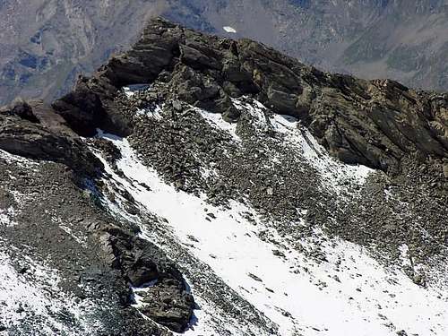
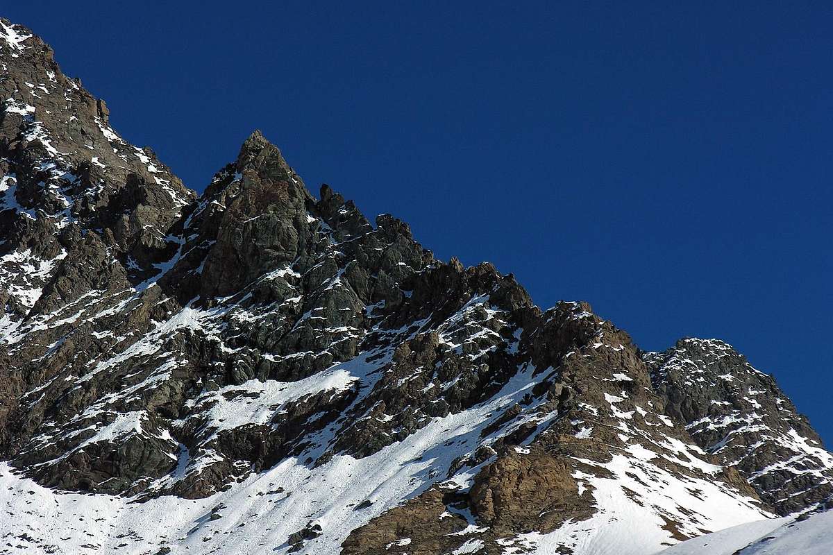
c) - from the Valley of Fénis/Clavalité: to reach Grand Alpe Pasture and from this the Glacier de la Pointe Tersiva; finally with slope of the same one on his Oriental Face with steep run and statement to the fall of stones and for this motive, to tell the truth, a little frequented. Connection of Paths: through path-dirt "poderale" road n° 2 from Fénis Barche Fraction to Clavalité Tableland in fork 1.551 meters, between Bioley Damon and Crin Villages nearby the Bayette Wood. Path n° 5 to alternative 2.027 meters and final part through path n° 6 towards Grand-Alp Pasture; after through path n° 7/102 to Lavodilec Loch as far as quota 2.127 meters and free route in terminal part on Tersiva Glacier to pass. 2) - Great Crest E-NE: with the preceding one it rather contains by now the rests of the meeting place Glacier de the Pointe Tersiva with traces of glaciation up to the 2.850/2.900 meters. It goes up again awry immediately some grassy and rocky promontories soprastanti the Pastures of Grand Alp (2.120m), where it has beginning the tall Comba Tersiva; it is almost exclusively a rocky crest that constitutes the Normal Route, or at least surely the more frequented, from the Valley of Fénis, even if from this last it is possible to reach the Hill of the Tersiva and to continue along the Crest N-NW (more binding and delicate in the underlying line to the collar). From the Peak it goes down above the Pastures of Grand-Alp, after to first common line, with three great parallel crests, of which dark that to North, to border left hydrographical of the Glacier de the Pointe Tersiva, constitutes the route of slope. From an analysis from the lower part he introduces more difficulty than is not it; if integrally crossed on the thread it also proposes passages of IV-/IV°(all with possibility of avoidance), as from information of "Battisten" Pieiller, of Fénis Municipality, that has crossed it from the forty to the fifty times and as such the KING of this Great Crest can be considered justly. Analyzing the crest in slope is possible to divide it in four sections (you see great photo in opening of "Overview"): a first turned rocky line mostly to North-northeast that flanks the left edge of the Glacier de la Pointe Tersiva, with more rotten rocks; a second turned steep prominence more to East that brings at times to a small snowy crest (as in this photo) and rectilinear pseudo, that finishes with two rocky asperities. Finally a last great rocky jump-wall that, going to melt herself with the Wall North-northeast on the right and with the others two great parallel ribs toward South, directly hands to the Summit. In reality the two great turned dark ribs to East-southeast they already belong to the Face Southeast and are two great pillars of support of the great same crest. In every case climbed long of over 1.200 meters gradient in the line above the Alp and to consider him "mysticism", if effected from the floorvalley or from the Village of Barche, to the beginning of the dirt road "poderale" of the Clavalité large Valley or, better, Tableland. Connection of Paths: through path-dirt "poderale" road n° 2 from Fénis Barche Fraction to Clavalité Tableland in fork 1.551 meters, between Bioley Damon and Crin Villages nearby the Bayette's Wood. Path n° 5 to alternative 2.027 meters and final part through path n° 6 towards Grand-Alp Pasture; after through path n° 7/102 to Lavodilec Loch as far as quota 2.127 meters and, free, Southern deviation to quota 2.518 meters at base of the ridge.
VARYING: with run a few directly but surely more comfort, to still continue on the same path abandoning it when it begins to climb more steeply; to take a small path not numbered on the left instead (West), that reaches the little one and from the forms exotic Shelter of the Marquis Turati (private and closed). From this, turning to Midday, on traces among the pastures to reach the impending moraine, holding to the right himself of the precedent run, to mostly reach the great crest in an elevated point, near the quota 3.338 meters I.G.M
Subdivision of the approaches with departure from three different valleys, as well as respective paths: d) - Valley of Fénis/Clavalité/Tall Comba Tersiva: as the preceding approach up to Grand-Alp and prosecution with the path n° 6 toward South through the High Comba Tersiva pour the Hill of Fénis (2.857m); from this, crossing her "Chemin du Roi", with the path n° 8 coming from Dondena to the neighbor with the Pontonnet. e) - Valley of Cogne/Walloon of the Urtier: with the preceding Approach itinerary n° 1/b up to the alternative 2.507 meters for the Alpage of Invergneux; therefore to East with the path-dirt road "poderale" n° 10F/TVC for the Ponton Pasture up to the alternative 2.641 meters, near her "Baita of Hunters Orlando", and finally with the path n° 10E for the Lakes of the Pontonnet and homonym Hill. f) - Valley of Champorcher: from the Chief town of Chateau (1.427m) for the Royal Road (excavated and open to the vehicles) for Dondena; from the bridge on the Stream Ayasse with the path n° 7B/7C/Haute Route n° 2 to the Refuge de Dondena (2.193m) and he actually still with the same one to the small bridge that crosses the stream toward North. Finally with the path n° 8/8A/8B/8C; you abandon the deviations of these two last for the Fussy and Moussaillon Hills, to continue with 8A for the Fénis Pass, as well as precedent approach. (VARYING: dark or shortcut to North with to small path not numbered but in evidence, that from the hairpin bend among l "Hotel" and the ruins of the ex Barracks it climbs through the pastures near to small torrent and, overcoming two alps, it always conducts to the road excavated for the Miserin inserting itself to quota 2.250 meters around; and besides with the possibility to reach the superior bridge on the Ayasse departing from that inferior, near a gym of rock and with run on a trace of path also it not numbered that it climbs in parallel to the same one, immediately reaching a wide tableland after the bridge.) 4) - Crest S-SW: crest that begins around to 2.820 meters between the Alps of the Invergneux or des Hevergnes (2.524m) to West and those of the Alpages of Ponton (2.631m) more to East, dividing two small secondary vallons, named Cerise Plains, to the slopes of the South Walls and Southwest about the mountain. Very rarely frequented, even if from the attractive aspect for his numerous towers that make to imagine an attractive scaling (passages of III°+/IV° and even of V°), but the quality of the rock doesn't allow to presage nothing of good person. Paths with the preceding approaches-itineraries n° 1/b and n° 3/e up to the alternative 2.507 meters for the Alpage of Invergneux; therefore to East with the path-dirt road "poderale" n°10F/TVC for the Ponton Pasture up to the alternative 2.641 meters, near her "Baita of Hunters Orlando". From this, or just before, without obliged route into moraine to base of crest. 5) - Ridge W-SW: long crest that begins from the Pas des Invergneux (2.902m) and that it constitutes the Normal Street with departure from Lillaz and through the first part of the Valley of the Urtier up to the alternative 2.360 meters before the Alpage de La Manda (2.374m). It crosses the long crest he dictates The Serra Madù or Madou up to the homonym point (3.220m); from this a brief descent (not always simple if the slant is covered from "verglass") hands on the Glacier of the Tessonet, that is crossed toward Northeast rejoining itself to the Route of the Crest N-NW. Or he continues on the same crest and, after a brief descent to the collar 3.198m and overcome the quota 3.282m, with easy passages but exposed the Peak it is reached after a brief more binding final passage (II°+/III°-). * * * It surely constitutes the current NORMAL ROUTE and the more one frequented, with run however only up to the Serra Madù and crossing toward North of the Glacier of the Tessonet to the Tersiva Hill, abandoning so on the left the conclusive part of the great crest that, revolt to East, a West Crest becomes (clearly once enough of fashion). Approach with relative paths: this is the good Approach to the mountain, thanks to the opening of the Shelter Sogno di Berdzé (2.537m) near the near Alp of Peradzà, underlying to the Fenetre de Champorcher (2.826m; with possibility therefore to also use it arriving from the Valley of Champorcher through the path 7B of the "Chemin du Roi" or with the Haute Route n° 2 coming from the Lake and Refuge of the Miserin 2.579m and 2.588m); so doing himself "it breaks" the ascension in two days, avoiding to effect the long ascent from Lillaz in day and passing from the Alp of Invergneux to reach the homonym pass, at the base of the real ridge. With the precedent Approach n° 3 to reach the alternative 2.360 meters and, leaving on the left (North) the deviation for the Alps of the Invergneux and the Ponton. To always continue instead to East with the path n° 10 reaching first the La Manda Pasture (2.374m) and then along the Torrent of Peradzà the shelter, immediately afterwards a splendid source into a boulder. Same give, actually returning a little back a to the hairpin bend 2.498 meters, to take the path unnumbered of connection that in diagonal toward Northwest it crosses the rocky promontory at the base of the Loch Ponton reaching the impending dirt road "poderale" that follows him for brief line. To continue with the path 10D/TVC, same direction, toward the Footstep of Invergneux. NOTE TOPOGRAFICHE e SENTIERISTICA. Creste e Crestoni La Tersiva costituisce una delle vette più importanti di quella vasta area, subito a Meridione della Catena vera e propria del Gran Paradiso, ed estendentesi subito a Sud del Fiume Dora Baltea percorrendo così mezza Valle d'Aosta tra i Comuni di Aymavilles e di Pont Saint Martin ed inoltre verso Sudest tutta la Valle di Champorcher insino ai confini con la Regione Piemonte. In quest'enorme zona comprensiva belle cime come il Monte Emilius (3.559 m), la Catena della Grande Roise (3.356 m), la Punta Garin (3.451 m), il Mont Delà (3.139 m), il Mont Glacier (3.186 m), il Monte Avic (3.006 m) con il suo Parco Naturale e sul lato opposto, oltre il Torrente Ayasse ed al confine con la Valle dell'Orco/Ceresole Reale, la Rosa dei Banchi (3.164 m); tra tutte queste antiche piramidi, che viste da Nordest al calar del sole danno un'illusione struggente apparendo come quelle dell'Egitto, la Tersiva é seconda in altezza al solo Monte Emilius. Posizionata pressoché al centro di questa grande area invia le sue creste e precipita le sue pareti sulle Valli di Cogne (Valloni dell'Urtier e del Grauson) e di Fénis/Clavalité; ma la sua lunga Cresta Sud-sudest in direzione delle due Torri e del Col Pontonnet va a lambire anche la Valle di Champorcher. Questa montagna risulta essere una perfetta piramide composta da cinque creste ed altrettante pareti; quattro di queste creste salgono direttamente alla Vetta, mentre la quinta o Cresta Sud-sudovest va a congiungersi con la Cresta Sud-sudest, proveniente dal Colle Pontonnet (2.897 m), appena prima della Cima a quota 2.457 m. Le altre creste, analizzando la montagna in senso orario a partire dalla Cresta Nord-nordovest o via normale, presentano queste caratteristiche: 1) - Cresta N-NO: è la parte terminale del lungo contrafforte spartiacque divisorio le Valli di Cogne a Sudovest e l'Alta Comba Tersiva nella Valle di Fénis/Clavalité ad Est-nordest; la stessa proviene dalla Punta del Tessonet (3.266 m) e, dopo aver formato le Quote 3.188 m, 3.213 m, 3.273 m, 3.280 m, 3.305 m e 3.327 m, conosciute come Costa del Tessonet, scende brevemente al Colle della Tersiva (3.310/2 m) per poi concludere in vetta con una salita lineare su di una traccia di sentiero, qualora non si presenti innevata (in genere Luglio ed Agosto ed, a volte, pure Settembre e metà Ottobre). Questo tratto finale presenta ancor oggi un'aspetto innevato con cornici nevose in inizio di stagione, ma fino ad una quarantina di anni orsono lo era praticamente per tutto l'anno (* vedi varie fotografie del Settembre 1974). Ascensione alquanto piacevole ed elegante con la neve, altrimenti la cresta diventa banale e molto meno attraente a causa del detrito in alcuni tratti (specialmente sotto il Colle della Tersiva) ed inoltre fastidioso.
Per poterla percorrere si deve raggiungere il Colle della Tersiva con tre possibilità: a) - dal Vallone del Grauson: dal Villaggio di Gimillan o, in patois, Dzimillan risalire agli Alpeggi dell'E'closeur, Alpe Pila ed al Grauson Vieux; al bivio, subito dopo questo vecchio insediamento, lasciare sulla sinistra il successivo per il Lago Corona od i quattro Laghi di Lussert e procedere invece sulla destra verso l'Alpe di Pralognan e la seguente di Ervi(e)llères. Da qui (vedi nel dettaglio le Routes) salire verso il Ghiacciaio del Tessonet contornandolo sulla sinistra e, su tracce nella morena laterale e segnalazioni con ometti in pietra, raggiungere la base del Colle al quale si arriva con un tratto più erto su fine morena. Probabilmente corrisponde alla via della prima salita nel 1842. Sentieri: n° 8 dal Parking presso il Villaggio di Gimillan insino alla congiunzione dei Torrenti Ervillères/Doreire a quota 2.630/50 metri circa e dopo senza percorso obbligato. Oppure e meglio: poi con un sentierino non numerato, che supera una gola a fianco di un promontorio roccioso. Lo stesso termina diventando una traccia sempre meno evidente (ometti e tumuli) nei pressi di un altopiano morenico ondulato dentro al quale occhieggiano alcuni laghetti, residuo del ritiro progressivo del Ghiacciaio del Tessonet (oggi intorno ai 2.975/3.000 metri circa) e da qui con la morena laterale destra (Nord) o con il margine del ghiacciaio alla base del colle. b) - dal Vallone dell'Urtier: tramite l'Alpe ed il Col des Invergneux, il percorso dell'intera Serra Madù o Madou, discesa da quest'ultima sul Ghiacciaio del Tessonet e traversata da Sud a Nord del medesimo ricongiungendosi all'itinerario precedente alla base del colle (a proposito di questa traversata vedere le sezioni precenti e successiva "Historical, Toponymic Notes" & "Various Anecdotes"). Sentieri: n°13/TVC/Haute Route n° 2 dal Parking presso la Frazione di Lillaz insino al bivio 2.357 metri; sentierino non numerato in direzione dell'Alpeggio Broillot e susseguente liaison dei sentieri-strada poderale n°13A/10/10D verso l'Alpe dell'Invergneux ed omonimo Colle. c) - dalla Valle di Fénis/Clavalité: raggiungere Grand-Alp e da questa il Glacier de la Pointe Tersiva; infine con risalita del medesimo sulla sua Faccia Orientale con percorso ripido ed esposto alla caduta di pietre e per questo motivo veramente poco frequentato.
2) - Crestone E-NE: con la precedente racchiude i resti dell'ormai alquanto ridotto Glacier de la Pointe Tersiva con tracce di glaciazione fino ai 2.850/2.900 metri. Risale subito a monte dei promontori erbosi e rocciosi soprastanti l'Alpeggio di Grand Alp (2.120 m), dove ha inizio l'Alta Comba Tersiva; è una cresta quasi esclusivamente rocciosa che costituisce la Via Normale, od almeno sicuramente la più frequentata, dalla Valle di Fénis, anche se da questa ultima è possibile raggiungere il Colle della Tersiva e proseguire lungo la Cresta N-NO (più impegnativo e delicato nel tratto sottostante al colletto). Dalla Vetta discende sopra l’Alpe di Grand-Alp, dopo un primo tratto comune, con tre crestoni paralleli, dei quali quello più a Settentrione, a margine idrografico sinistro del Glacier de la Pointe Tersiva, costituisce la via di salita. Da un'analisi dabbasso si presenta più difficile di quanto non lo sia; se percorsa integralmente sul filo propone passaggi anche di IV°-/IV° (tutti aggirabili), come da informazioni del fénisano "Battisten" Pieiller che l'ha percorsa dalle quaranta alle cinquanta volte e come tale può essere giustamente considerato il RE di questa Grande Cresta. Analizzando la cresta in salita è possibile dividerla in quattro sezioni (vedi foto grande in apertura di "Overview"): un primo tratto di roccia più rotta rivolto maggiormente a Nord-nordest fiancheggiante il bordo sinistro del Glacier de la Pointe Tersiva; un secondo risalto più ripido rivolto più ad Oriente adducente ad una crestina a volte innevata (come in questa foto) e pseudo rettilinea, che termina con due asperità rocciose. Infine un ultimo grande salto a mò di parete rocciosa che, andando a fondersi con la Parete Nord-nordest sulla destra e con le altre due grandi costole parallele verso Sud, porta direttamente alla Sommità. In realtà le due grandi costole rivolte più a Est-sudest fanno già parte della Faccia Sudest e costuiscono due grandi pilastri di sostegno della grande cresta medesima. In ogni caso salita lunga di oltre 1.200 metri circa di dislivello nel tratto sopra l'Alpe e da considerarsi "mistica", se effettuata dal fondovalle ovvero dal Villaggio di Barche, all'inizio della strada poderale della Clavalité. Collegamento dei sentieri: "poderale"-sentiero n° 2 da Fénis Frazione Barche verso l'Altopiano della Clavalité insino al bivio 1.551 metri, tra i Villaggi di Bioley Damon e Crin al limitar del Bois de Bayette. Sentiero n° 5 fino al bivio 2027 metri e parte finale tramite sentiero n°6 attraverso Grand-Alp; infine per mezzo del sentiero n° 7/102 per il Lago di Lavodilec fino a quota 2.127 metri e percorso terminale a Meridione, non obbligatorio, verso la base del crestone alla quota 2.518 metri. VARIANTE: con percorso un pò meno diretto ma sicuramente più comodo, proseguire ancora sullo stesso sentiero abbandonandolo quando inizia salire più ripidamente; prendere invece un sentierucolo non numerato sulla sinistra (Ovest), che raggiunge il piccolo e dalle forme esotiche Rifugio del Marchese Turati (privato e chiuso). Da questo, volgendo a Mezzogiorno, su tracce tra i pascoli raggiungere la soprastante morena, tenendosi più a destra del precedente percorso, e raggiungere il crestone in un punto maggiormente elevato, presso la quota 3.338 metri I.G.M. 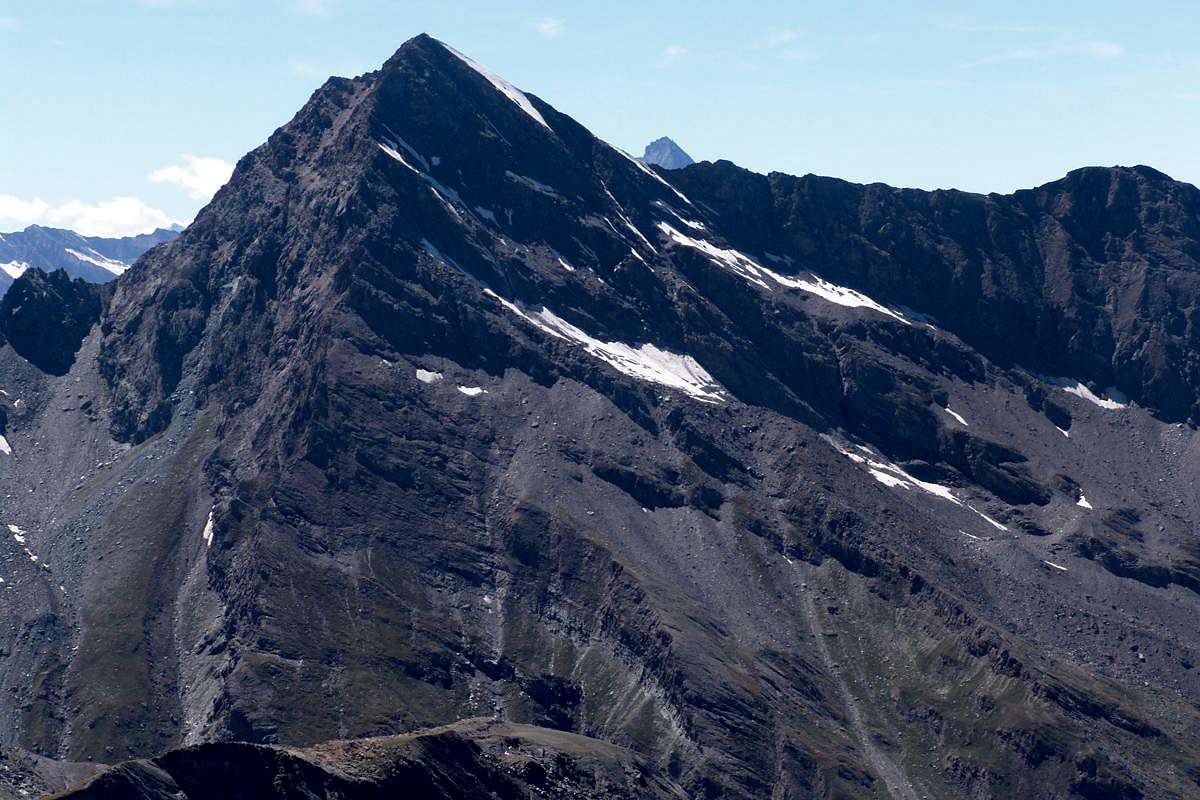 3) - Crestone S-SE: prende le sue origini dal Colle Pontonnet (2.827 m, raggiungibile sia dalla Valle di Cogne per il lungo Vallone dell'Urtier con partenza dal Villaggio di Lillaz (1.631 m), sia da quella di Champorcher con percorso analogo partendo da Dondena (2.100 m); la stessa prima forma le due sommità della Tour Pontonnet, divise dal Colletto 3.148 m, poi discesa ad un successivo e più marcato Colletto 3.085 m, risale meno frastagliata, ma con qualche passaggio roccioso interessante, andando a congiungersi con la Cresta SO ad un'ottantina di metri dalla Vetta. Percorso abbastanza frequentato, anche per le segnalazioni con vernice gialla. La stessa cresta, effettuabile con diversi aggiramenti, molto probabilmente non é stata ancora salita sul filo dal Colle Pontonnet alla Vetta, scavalcando le due Torri Pontonnet (3.173/4 m la Punta SE e 3.185 m la NO) ed alcuni tratti successivi; presenta difficoltà da PD a AD e passaggi di II°/II°+/III°-/III° (presso una torre rossiccia a quota 3.330 metri circa, con possibilità di scalarla direttamente per mezzo di un camino roccioso uscendone a sinistra oppure aggirandola ad Ovest) con il percorso segnalato, ma sicuramente superiori e su roccia non troppo buona nel caso di salita integrale. E’possibile inoltre evitare le due torri scendendo ad Ovest nella piccola conca morenica, sottostante la Parete Sud, e risalire sulla cresta tramite pendii morenici, a volte innevati, che portano per mezzo di un canalino incassato ad una forcella a quota 3.150 metri circa subito a Settentrione della frastagliata guglia 3.171 metri (via raramente percorsa perché poco conosciuta e maggiormente esposta alla caduta di pietre; più lunga del percorso tradizionale segnalato ed in ogni caso sconsigliabile). Suddivisione degli avvicinamenti con partenza da tre vallate diverse, nonché sentieri relativi:
d) - Valle di Fénis/Clavalité/Alta Comba Tersiva: come il precedente avvicinamento fino a Grand-Alp e prosecuzione con il sentiero n° 6 verso Sud attraverso l'Alta Comba Tersiva verso il Colle di Fénis (2.857 m); da questo, incrociando le "Chemin du Roi", con il sentiero n° 8A proveniente da Dondena al vicino Col Pontonnet. e) - Valle di Cogne/Vallone dell’Urtier: con il precedente Avvicinamento itinerario n° 1/b fino al bivio 2.507 metri per l'Alpe d'Invergneux; quindi ad Est con il sentiero-"poderale" n°10F/TVC per l'Alpe Ponton fino al bivio 2.641 metri, presso la "Baita dei Cacciatori Orlando", ed infine con il sentiero n° 10E per i Laghi del Pontonnet ed omonimo Colle. f) - Valle di Champorcher: dal Capoluogo di Chateau (1.427 m) per la Strada Reale (sterrata ed aperta ai veicoli) per Dondena; dal ponte sul Torrente Ayasse con il sentiero n°7B/7C/Alta Via n°2 al Refuge de Dondena (2.193 m) ed ancora con la medesima sino al ponticello che attraversa il torrente verso Nord. Infine con il sentiero n° 8/8A/8B/8C; abbandonate le deviazioni di questi due ultimi per i Colli Fussy e Moussaillon, continuare con il n° 8A per il Col Fénis, nonché precedente avvicinamento. (VARIANTI: oppure scorciatoia più a Settentrione con un sentierino non numerato ma ben in evidenza, che dal tornante tra l'Albergo e le rovine dell'ex Caserma sale attraverso i pascoli presso un torrentello e, superando due alpeggi, conduce sempre alla strada sterrata per il Miserin inserendosi a quota 2.250 metri circa; ed inoltre con la possibilità di raggiungere il ponte superiore sull'Ayasse partendo da quello inferiore, presso una palestra di roccia e con percorso su di una traccia di sentiero anch'essa non numerata risalente in parallelo al medesimo, raggiungendo un largo pianoro subito appresso il ponte). 4) - Cresta S-SO: cresta che inizia a 2.820 metri circa tra gli Alpeggi dell'Invergneux o des Hevergnes (2.524 m) ad Occidente e quelli dell'Alpe Ponton (2.631 m) più ad Oriente, dividendo due piccoli valloni secondari, detti Plans de Cerise, alle pendici delle Pareti Sud e SO del monte. Molto raramente frequentata, anche se dall'aspetto attraente per i suoi numerosi torrioni che fanno immaginare una scalata attraente (III°+/IV° con passaggi anche di V°), ma la qualità della roccia non lascia presagire nulla di buono. Sentieri con i precedenti avvicinamenti-itinerari n° 1/b, nonché 3/e, fino al bivio 2.507 metri per l'Alpe dell'Invergneux; quindi ad Est con il sentiero-"poderale" n° 10F/TVC per l'Alpe Ponton fino al bivio 2.641 metri, presso la "Baita dei Cacciatori Orlando", oppure immediatamente prima senza percorso obbligato all'interno della morena.
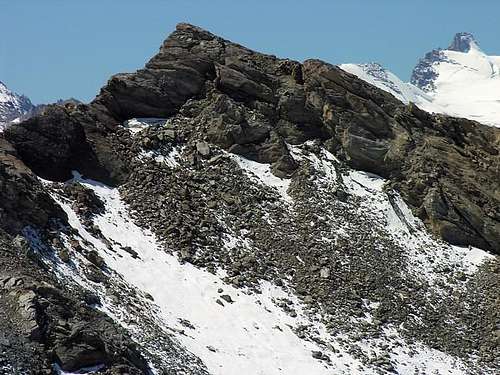
5) - Crestone O-SO: lunga cresta che prende le mosse dal Pas des Invergneux (2.902 m) e che costituisce la Via Normale con partenza da Lillaz ed attraverso la prima parte del Vallone dell'Urtier insino al bivio 2.360 metri prima dell'Alpe de la Manda (2.374 m). Percorre la lunga cresta detta Serra Madù o Madou fino all'omonima punta (3.220 m); da questa una breve discesa (non sempre semplice se il pendio è ricoperto da "verglass") porta sul Ghiacciaio del Tessonet, che s'attraversa verso Nordest ricongiungendosi alla Via della Cresta N-NO. Oppure si continua sulla stessa cresta e, dopo una breve discesa al colletto 3.198 m e superata la quota 3.282 m, con tratti facili ma esposti si raggiunge la Vetta dopo un breve passaggio finale più impegnativo (II°+/III°-). * * * Costituisce attualmente la VIA NORMALE con percorso però solo fino alla Serra Madù ed attraversamento verso Settentrione del Ghiacciaio del Tessonet in direzione del Colle della Tersiva, abbandonando così sulla sinistra la parte conclusiva della grande cresta che, rivolta ad Est, diventa nettamente una Cresta Ovest (una volta abbastanza di moda). Avvicinamento con relativi sentieri: questo é il miglior Approccio alla montagna, grazie all'apertura del Rifugio Sogno di Berdzé (2.537 m) presso la vicina Alpe di Peradzà, sottostanti alla Fenetre de Champorcher (2826 m; con possibilità quindi di utilizzarlo anche arrivando dalla Valle di Champorcher tramite il sentiero 7B del "Chemin du Roi" o con l'Alta Via n° 2 proveniente dal Lago e Rifugio del Miserin 2.579 m e 2.588 m); così facendo si "spezza" l'ascensione in due giornate, evitando d'effettuare la lunga salita da Lillaz in giornata e passando dall’Alpe d’Invergneux per raggiungere l’omonimo colle, alla base della cresta vera e propria. Con il precedente Avvicinamento n° 3 raggiungere il bivio 2.360 metri e, lasciando sulla sinistra (Nord) la deviazione per le Alpi dell'Invergneux e del Ponton. Proseguire invece sempre ad Est con il sentiero n° 10 raggiungendo prima l'Alpe de La Manda (2.374 m) e poi lungo il Torrente di Peradzà il rifugio, appena dopo una bella sorgente sgorgante da un macigno. Dallo stesso, ritornando un poco all'indietro sino al tornante 2.498 metri, prendere il sentiero di collegamento non numerato, che in diagonale verso Nordovest attraversa i promontorii rocciosi alla base del Lago Ponton raggiungendo la soprastante strada poderale che si segue per breve tratto. Continuare con il sentiero 10D/TVC, stessa direzione, verso il Passo d'Invergneux. 6) - Wall N-NE: it deals with the elegant triangular wall impending the minuscule Glacier of the Tersiva; limited to the right from the Crest N-NW and to the left from the long "Crestone" E-NE, that respectively constitutes the Normal Routes of climbed from the Valley of Cogne (possibility of had climbed since two separate Valleys of the Grauson or the Urtier) and from Fénis/Clavalité Valley; it goes down, broken by three separate rocky bands interrupted from steep snowfields, for over 500 meters around progressively attenuating his inclination against the frontal moraine of the same one. He is ploughed in his center by a long and great sinuous gully, that is undoubled to around 220 meters by the Peak against a rocky band to form of pear tilted toward left; his left branch (East) it goes out on the Great Crest E-NE to few meters of the Top, while that opposite opens upward to form of funnel transforming itself in a white and elegant sheet snowy. Less interesting the side of right of the wall that is dissolved in snowcapped intercalated by small rocky bands thin against the Hill of the Tersiva. Surely in more remote times the same one had to almost entirely have covered from a great snowy slant with inclinations among the 40° and the 50°/55° from which as soon as small scattered rocks appeared on the surface. It is surely the most binding via of the mountain; a little frequented, is returned in top in the last years thanks to the appointment of mountain climber of Fénis, Saint Marcel and Quart three Municipitalities.
Approach: similar to these of itineraries 1 e 2 (Tersiva Pass and Great Ridge E-NE) and basic VARYING immediately afterwards Grand-Alp Pasture (2.120m). 7) - Face SE and Slope E-SE: the great Southern Wall turns toward Southeast above the final part of the Tall Comba (= Basin) Tersiva before the Hill of Fénis you divides into two well separate parts: Face SE and Slope E-SE or Couloir de the "Grande Raye": the imposing Slope E-SE some mountain is undoubled, especially in the most elevated part, distinguishing on the left a less steep slope and formed by deposits with blocks of rock that, through a great rocky channel, it goes up again it from quota 3.060/70 meters around reaching the great Ridge E-SE, after the two Pontonnet's Towers, immediately above quota 3.457m, near a great ledge known by the local mountain climber with the name of the "Grande Raye"; on the right instead a steep wall also it formed by broken and broken rocks directly goes up again with more southeast exposure to the Peak with a terminal part though a wall of 150 meters around, very exposed. The first run is known on the spot as "Voie de the Great Raye", or "Route of the Great Ledge" and it constitutes alternative an to the great and long Ridge E-SE it for the mountain climber of Fénis, from which it is rather frequented; the wall to side instead, as to make as we know, it doesn't result crossed (* * even if in the "Book of Peak of the Tersiva" since 1921 until to the September 1974 an ascension is recorded from four mountaineers "Cognensi" (? or of Champorcher Valley ??) in 1952 but, to our notice it turns to the South Wall; you see more before the "HISTORICAL NOTES") and he should offer, from an analysis from the lower part or frontal from the Tower Ponton or from the Mont Moutsaillon, scrambled an enough difficult and surely dangerous for the quality of the rock and the suspended material. (*** To the necessity and always in SP, to go to see in "ALL ROUTES (20 + 1 historical) OF PUNTA TERSIVA") to the itineraries n° 6 and n° 6bis enclosing a photo with their tracks of the routes).
Approach: equal to these of itineraries 1, 6 and 2 (Tersiva Pass, North-northeast Wall and Great Ridge E-NE) and basic VARYING, immediately afterwards Grand-Alp Pasture. From Alp (2.120m), over and side by side with the Clavalité Torrent, through the path n° 6 towards Tall Tersiva's Basin up to the resort also called the "Grand Ra(e)ye" and final approach to Western on moraine with not forced route.
8) - Face S: the hold Face South, that doesn't exist for anybody other preceding publication almost it didn't exist, it is not a ghost given birth by a fervent imagination, on the contrary it really subsists and it is inclusive among the great Ridge E-SE that from the Peak it goes down to the Hill Pontonnet and the Crest S-SW that from the quota 3.457m or Antesummit Southern to the conjunction with the preceding one, go down actually to the quota 2.820m forming a series of showy pinnacles and steeples. Of triangular form and hold, it was almost compressed from the two crests above you quotas, salt above a minuscule walloon of which out goes out some rivulets inside the moraine of basic impending the path n° 10E for the Lakes Pontonnet in direction of the homonym pass. The same, departing from it "The Hunters Cabin Orlando" (2.641m) with direction North, goes up again at first a steep rump for then to turn around brusquely around 2.760/70 meters to straight angle in direction of the footstep. Above this passage, after a brief grassy slant with deposits, the small foretold vallone raises him; this goes up again more and more from the quota 2.808 meters through a steep moraine toward the base of the wall to quota 3.000 meters around breaking itself against the rocky clog of the same one. From this point the wall raises him, ploughed in its mean by an a little also accented channel it rocky, for over 450 meters to finish to the quota 3.457m; constituted by broken rocks and also minced surely doesn't introduce attractions for the climb with notable objective dangers for the fall of stones. And it is for this motive that ascensions of the same one don't be recorded, unless in 1952 the four mountaineers of Cogne or of Champorcher (?) have not climbed her in first ascension, as from us supposed. The transcript on the "Book of the Tersiva 1921/1974" from the same ones he speaks however of Wall S-E. Don't wait him for a profitable climb, as already says, for the bad quality of the rock; to avoid in every case after recent snowfall or with the wall covered not by well transformed snow. In fact from a personal analysis, transiting under the same one with such conditions, the he is noticed to fall of numerous small snowslides. Approach: equal to these of itineraries 3/e and 4 (South-southeast Ridge and South-southwest Crest) and deviation to Northern from the path n° 10E to quota 2.808 meters at the beginning of basal moraine, with free route on the same up to the base of face. 9) - Wall S-W: wider and also steep, but shorter even if of few, the Wall SW salt from the moraines impending the so said Plan de Cerise from the moraine to quota 3.100 meters around directly to the Peak. Understood in a vast and imposing amphitheater formed by the Crest S-SW on his right and from the long Ridge W-SW said of the Serra Madù, that reaches, climbing over some small quotas, the Pas des Inverneux (2902m). You raises therefore for 415 meters around, uniform in separate two sectors from to great rocky central channel, to go out and directly and easily reaching the Peak in dark his Western side, nearby the new Statue of the Virgo. Probably slope an only turned by the rope of September 1898 with itinerary i don't notice, but almost surely supporting himself on the sides of the aforesaid couloir; its slope appears from an analysis from the lower part it more difficulty than is not it indeed as it shows the time employed by the first mountaineers (2h'15). It also results certainly exposed, as in effects all the routes on the walls of this ancient mountain, to the falls of stones.
Approach: the same of itineraries n° 5 and n° 4 (W-SW Ridge and in parallel S-SW Crest and following deviation to Northern from the path n° 10D/TVC to quota 2.849 meters at the beginning of basal moraine, with "free" trail on the same up to the base of the face in quota 3154 metres. Or identical to these of itineraries 3/e and 4 (Great Ridge S-SE and parallel S-SW Crest and following deviation in Northwest from the path n° 10E near the "Baita dei Cacciatori Orlando", through a small path of connection not numbered to the path 10D/TVC in quota of 2.650/700 meters about, and as far as the beginning of basal moraine.
10) - Wall N-NW: it deals with the last of the walls, also from the chronological point of view of the slopes being dated September 1988 in the analysis clockwise effected. You raises above the most Oriental borders of the Glacier of the Tessonet, also known as Glacier Doreire, ancient name of the Point Tersiva (550 meters around in width and almost 800 meters in length, as from the last surveys); from quota 3.220 meters around it climbs to the Peak with a gradient of 300 meters around dominating, to form of stumpy and strong pyramid, the same one. Its structure is formed from a flared channel and sinuous that divides it in two well separate parts: that of left or Northern it is formed from a rocky rib that accompanies climbing in its sketch the great central couloir, descending gradually then less steep and very interesting with deposits and broken rocks I pour the Pass of the Tersiva; more attractive the right or Southern part, formed by a wide and steep wall supported by three rocky-ribs/pillars basal up to around its half, where the same go to melt themselves in an only wall of rotten rocks, very dangerous for the discharges of stones. The slope bringing itself to the attack with the overcoming of a series of crevasses from the right toward the left was effected for then grabbing the first rib/pillar of left of the aforesaid three. The same one was gone up again on its near side of left but out of the great central gully; overcome a series of small rocky strips horizontal pseudo the same one, it concluded him supporting in the last 70/80 meters in the same couloir with which to go out of the wall, where the two Crests West-southwest and South-southwest they gather him above the Wall Southwest, and with a terminal line of not great inclination finally and directly reach the Peak to the feet of the Madonna. Climbed more dangerous than difficult, it asks for conditions of well transformed snow and absence of "verglass" on the rocks, factor that is rather rarely verified. To avoid to the right absolutely the sector through the others two small pillars and overhanging wall, subject to continuous discharges also of boulders, as it is deduced by the material deposited to his base on the Tessonet Glacier. Approach: like for the itineraries 1/a from Grauson's large Valley to N-NW Crest and brief crossing to East-southeast of the glacier, also 1/b from Urtier Valley towards the same through the Serra Madù and traverse of Tessonet Glacier in North-northeast direction. Versanti, Facce e Pareti
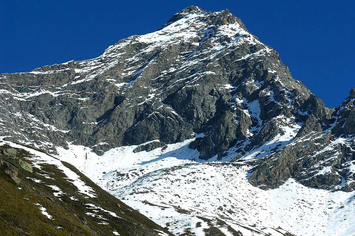
6) - Parete N-NE: trattasi dell'elegante parete triangolare soprastante il piccolo Ghiacciaio della Tersiva; limitata a destra dalla Cresta N-NO ed a sinistra dal lungo Crestone E-NE, che costituiscono rispettivamente le Vie Normali di salita dalla Valle di Cogne (possibilità di salita dai due distinti Valloni del Grauson o dell'Urtier) nonché del lungo Vallone di Fénis/Clavalité; scende, spezzata da tre distinte fasce rocciose interrotte da ripidi nevai, per oltre circa 500 metri attenuando progressivamente la sua pendenza contro la morena frontale del medesimo. E' solcata nel suo centro da un lungo canalone sinuoso, sdoppiantesi a circa 220 metri dalla Vetta contro una fascia rocciosa a forma di pera inclinata verso sinistra; il suo ramo sinistro (Est) esce sul Crestone E-NE a pochi metri dalla Cima, mentre l'opposto apresi verso l'alto a forma d'imbuto tramutandosi in un bianco ed elegante lenzuolo innevato. Meno interessante il settore di destra della parete, che si stempera in nevati intercalati da fascette rocciose fino contro il Colle della Tersiva. Sicuramente in tempi più remoti la stessa doveva essere ricoperta quasi per l'intero da un grande pendio nevoso con pendenze tra i 40° ed i 50°/55° dal quale appena affioravano roccette sparse. Risulta sicuramente la via più impegnativa della montagna; poco frequentata, è ritornata in auge negli ultimi anni grazie all'impegno di alpinisti dei tre Comuni di Fénis, Saint Marcel e Quart.
Avvicinamento: identico a quelli degli itinerari 1 e 2 (Colle della Tersiva e Crestone E-NE) e VARIANTE di base subito dopo Grand-Alp (2.120 m).
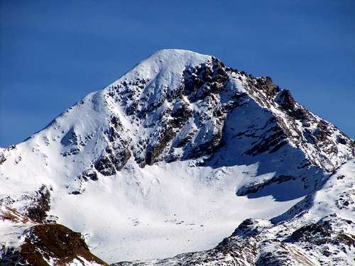
In the photo from Northern View: on the left the tall part of Great Ridge E-NE, frontally the midst-high of the N-NE Wall and in right the final of N-NW Crest or Standard Route. 7) - Faccia SE nonché Versante E-SE: la grande Parete Meridionale rivolta verso Sudest sopra la parte finale dell'Alta Comba Tersiva prima del Colle di Fénis si divide in due parti ben distinte: Faccia SE e Versante E-SE o "Couloir de la Grande Raye": l'imponente Versante E-SE della montagna si sdoppia, soprattutto nella parte più elevata, distinguendo sulla sinistra un versante meno ripido e formato da detriti con blocchi di roccia che, tramite un canalone roccioso, lo risale da quota 3.060/70 metri circa raggiungendo il Crestone E-SE, dopo le due Tours Pontonnet, subito sopra la quota 3.457 m, presso un cengione conosciuto dagli alpinisti locali con il nome della "Grande Raye"; sulla destra invece una parete più ripida, anch'essa formata da rocce rotte e spezzate, risale con esposizione più a Sudest direttamente alla Vetta con una parte terminale formata da una muraglia di 150 metri circa, piuttosto esposta. Il primo percorso è conosciuto in loco come "Voie de la Grande Raye", ovvero "Via della Grande Cengia" e costituisce un'alternativa al lungo Crestone E-NE per gli alpinisti di Fénis, dai quali è piuttosto frequentato; la parete a lato invece, per quanto è dato a sapersi, non risulta percorsa ( ** anche se nel "Libro di Vetta della Tersiva" dal 1921 insino al Settembre1974 viene registrata un'ascensione da parte di quattro "Cognensi" (? o di Champorcher ??) nel 1952 ma, a nostro avviso rivolta alla Parete Sud; vedi più avanti le "NOTE STORICHE") e dovrebbe offrire, da un'analisi dabbasso o frontalmente dalla Torre Ponton o dal Mont Moutsaillon, un'arrampicata abbastanza difficile e sicuramente pericolosa per la qualità della roccia, nonché per il materiale sospeso. ( *** All'uopo e sempre in SP, andare a vedere in "ALL ROUTES (20 + 1 historical) OF PUNTA TERSIVA") agli itinerari n° 6 e n° 6bis con allegata una foto con i relativi tracciati). Avvicinamento: similmente a quelli degli itinerari 1, 6 e 2 (Colle della Tersiva, Parete N-NE e Gran Cresta E-NE) nonché VARIANTE di base, immediatamente appresso Grand-Alp. Dall'Alpeggio (2.120 m), subito sopra e parallelamente al Torrente Clavalité, tramite sentiero n° 6 attraverso l'Alta Comba Tersiva ed insino alla località detta "Grand Ra(e)ye" con avvicinamento finale ad Occidente sulla morena e percorso non obbligato. 8) - Faccia S: la stretta Faccia Sud, che non é insita in nessuna altra precedente pubblicazione quasi non esistesse, non é un fantasma partorito da una fervida fantasia, bensì sussiste realmente ed é compresa tra la grande Cresta E-SE che dalla Vetta scende al Colle Pontonnet e la Cresta S-SO che dalla quota 3.457 m, o Antecima Meridionale alla congiunzione con la precedente, scende sino alla quota 2.820 m formando una serie di vistosi pinnacoli e guglie. Di forma triangolare e stretta, quasi fosse compressa dalle due creste sopra citate, sale al di sopra di un minuscolo vallone dal quale fuori escono alcuni rigagnoli all'interno della morena di base soprastante il sentiero n° 10E per i Laghi Pontonnet in direzione dell'omonimo colle. Lo stesso, partendo dalla "Baita dei Cacciatori Orlando" (2.641 m) con direzione Nord, risale dapprima una ripida groppa per poi svoltare bruscamente sui 2.760/70 metri circa ad angolo retto in direzione del passo. Sopra questo passaggio, dopo un breve pendio erboso con detriti, si innalza il piccolo vallone predetto; questo risale dalla quota 2.808 m tramite una morena sempre più ripida verso la base della parete a quota 3.000 metri circa infrangendosi contro lo zoccolo roccioso della medesima. Da questo punto la muraglia si innalza, solcata nel suo mezzo da un poco accentuato canale anche esso roccioso, per oltre 450 metri per terminare alla quota 3.457 m; costituita da rocce rotte ed anche trite, sicuramente non presenta attrattive per l'arrampicata con invece notevoli pericoli oggettivi per la caduta di pietre. Ed é per questo motivo che non si registrano ascensioni della stessa, a meno che nel 1952 i quattro alpinisti di Cogne o di Champorcher (?) non l'abbiano salita in prima ascensione, come da noi supposto. La trascrizione sul "Libro della Tersiva 1921/1974" da parte dei medesimi parla però di Parete S-E. Non aspettarsi una arrampicata remunerativa, come già detto, per la cattiva qualità della roccia; da evitare in ogni caso dopo recente nevicata o con la parete ricoperta da neve non ben trasformata. Infatti da un'analisi personale, transitando sotto la medesima con siffatte condizioni, si é notato il cadere di numerose piccole slavine.
Avvicinamento: uguale a quelli degli itinerari 3/e, nonché 4 (Crestone S-SE e parallela Cresta S-SO) e successiva deviazione a Settentrione dal sentiero n° 10E verso la quota 2.808 metri all'inizio della morena basale, con percorso "libero" della medesima insino alla base della faccia. 9) - Parete SO: più larga ed anche più ripida, ma più breve anche se di poco, la Parete SO sale dalle morene soprastanti il così detto Plan de Cerise dalla morena a quota 3100 metri circa direttamente alla Vetta. Compresa in un più vasto ed imponente anfiteatro formato dalla Cresta S-SO sulla sua destra e dalla lunga Cresta O-SO detta della Serra Madù, che raggiunge, scavalcando alcune piccole quote, il Pas des Inverneux (2.902 m). Si eleva quindi per 415 metri circa, divisa in due distinti settori da un canalone centrale roccioso, raggiungendo direttamente la Vetta nel suo lato più Occidentale, dove é stata posita la nuova Statua della Vergine. Probabilmente salita un'unica volta dalla cordata del Settembre 1898 con itinerario non noto, ma quasi sicuramente appoggiandosi sui lati del canale suddetto; la sua salita appare da un'analisi dabbasso più difficile di quanto non lo sia effettivamente come dimostra il tempo impiegato dai primi salitori (2h'15). Certamente anch'essa risulta esposta, come d'altronde tutte le vie sulle pareti di questa antica montagna, alle cadute di pietre.
Avvicinamento: uguale a quelli degli itinerari n° 5 e n° 4 (Crestone O-SO e parallela Cresta S-SO e successiva deviazione a Settentrione dal sentiero n° 10D/TVC verso la quota 2.849 metri all'inizio della morena basale, con percorso "libero" della medesima insino alla base della faccia a quota 3.154 metri. Oppure uguale a quelli degli itinerari 3/e e 4 (Crestone S-SE e parallela Cresta S-SO e successiva deviazione a Nordovest dal sentiero n° 10E presso la "Baita dei Cacciatori Orlando", con un sentierucolo di raccordo non numerato verso il sentiero 10D/TVC alla quota di 2.650/700 metri circa e fin all'inizio della morena basale. 
10) - Parete N-O: trattasi dell'ultima delle pareti, pure dal punto di vista cronologico delle salite essendo datata Settembre del 1988, nell'analisi in senso orario effettuatasi. Si eleva sopra i margini più Orientali del Ghiacciaio del Tessonet, conosciuto pure come Ghiacciaio Doreire, antico nome della Punta Tersiva (550 metri circa in larghezza e quasi 800 metri in lunghezza, come dagli ultimi rilevamenti); da quota 3.220 metri circa sale alla Vetta con un dislivello di 300 metri circa dominando, a forma di piramide tozza e robusta, il medesimo. La sua struttura é formata da un canalone svasato e sinuoso che la divide in due parti ben distinte: quella di sinistra o Settentrionale é formata da una costola rocciosa affiancante salendo nel suo disegno il grande canale centrale, digradando poi meno ripida e molto meno interessante con detriti e sfasciumi verso il Colle della Tersiva; più attraente la parte destra o Meridionale, formata da una larga e ripida parete sorretta da tre costole/pilastro basali fino a circa la sua metà, dove le stesse vanno a fondersi in un'unica muraglia di rocce rotte, alquanto pericolose per le scariche di sassi. La salita venne effettuata portandosi all'attacco con il superamento di una serie di crepacce dalla destra verso la sinistra per indi afferrare la prima costola/pilastro di sinistra delle tre suddette. La medesima fu risalita sul suo lato di sinistra vicino ma fuori dal grande canale centrale; superata una serie di piccole strisce rocciose pseudo orizzontali, la salita si concluse appoggiando negli ultimi 70/80 metri nel canale stesso con il quale uscire fuori dalla parete, dove le due Creste O-SO e S-SO si riuniscono al di sopra della Parete SO, e con un tratto finale di non grande pendenza infine raggiungere direttamente la Vetta ai piedi della Madonna. Ascensione più pericolosa che difficile, richiede condizioni di neve ben trasformata ed assenza di "verglass" sulle rocce, fattore verificantesi piuttosto di rado. Da evitare assolutamente il settore più a destra tramite gli altri due piccoli pilastri e soprastante parete, soggetta a scariche continue anche di macigni, come si evince dal materiale depositato alla sua base sul Ghiacciaio del Tessonet.
Avvicinamento: come per gli itinerari 1/a dal Vallone del Grauson per la Cresta N-NO e breve traversata ad Est-sudest del ghiacciaio, nonché 1/b dal Vallone dell'Urtier alla stessa tramite la Serra Madù e l'attraversamento del Ghiacciaio del Tessonet verso Nord-nordest. |
 |
Getting there
BY CAR:
|
BY PLANE:
- Aeroporto "Corrado Gex" Saint Christophe (Aosta).
 |
 |
 |
 |
 |
First Ascents
- Firs Ascent W Arête: P. B. Chamonin (Curate of Cogne) with a student, (Aug 23th, 1842).
- First ascent winter: Giuseppe Corona and others, (Feb 17th, 1875).
- S-E Arête: G. P. Carrel, J. A. Garth Marshall, P. Giacosa and E. Jantet, (Jul 1872).
- N-NW Arête: D. W. Freshfield and F. Dévouassoud, (Aug 1877).
- S-SW Arête: F. Santi and G. Cavagnot, (Aug 1895).
- S-W Wall: L. and R. Marchetti and L. Jantet, (Sep 01th, 1898).
- E Arête: E. Bravo, B. Garelli, C. Giachino, O. Nay, G.Pollano A. Maquignaz and others, (Jun 24th, 1901).
- N-NE Wall: Giovan Battista Bozzino and Arnaldo Bertucci, (Aug 21th, 1910).
- N-NE Wall Direct Route: Gigi Panei and Lucien Salval, (Sep 05th, 1937).
- Face S or Wall SE?: I. Minet, E. Gontier, N. Gontier and D. Glarey, (Jul 27th, 1952).
- N-W Wall: Osvaldo Cardellina, lone, (Sep 10th, 1988).
Routes
| ROUTE TO PUNTA TERSIVA FROM GIMILLAN
Difference in height: about 1.800 meters.
Ascent time: 7-8 hours.
Descent: along the ascent route.
Equipment: duvet, rope, crampons and ice-axe.
Go right starting from the car park of Gimillan: after few meters the indications for Lussert Lakes, St. Marcel Pass, etc. are found. The pathway is indicated by the yellow circle 9A and by yellow strips marked on stones along the route. The path begins going immediately uphill, then the slope decreases as we go beyond a little chapel dedicated to the Virgin (1.836m). Soon the path resumes to go up and splits in two, before it begins to penetrate into the Grauson Valley: it's possible to continue following the right one that goes down as far as the Ecloseur small Bridge (1.904m), but in such a case we must go up again; it's better to follow the left one that, in practice without losing height, arrives at the bridge under the Alpeggio Pila (2.025m), cross it and, following the stepped pathway, overcome the rocky bastion with a fine waterfall aside.
|
|
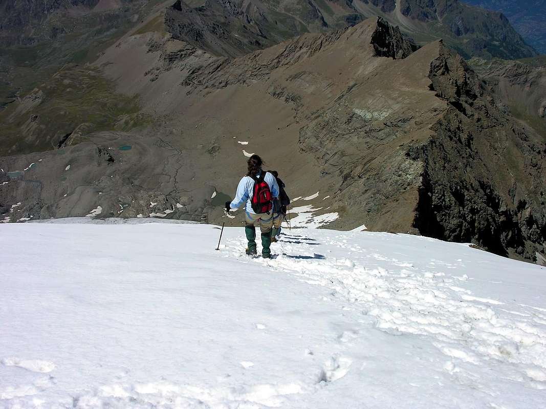
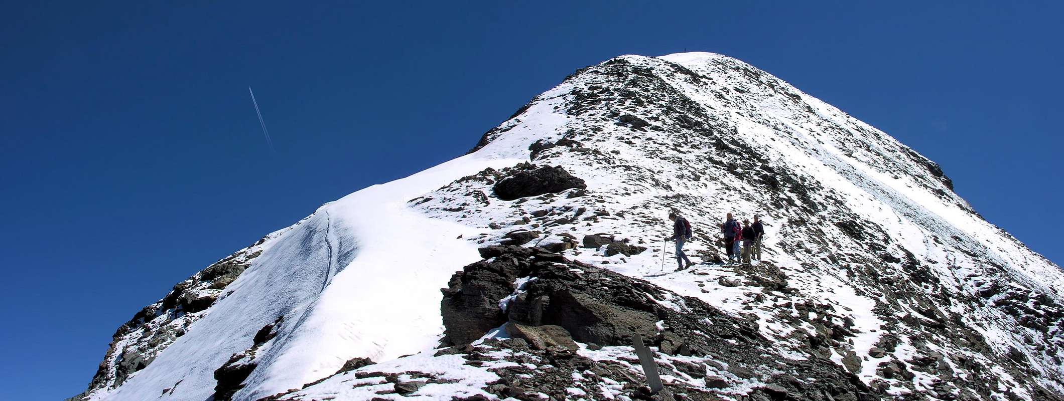
At this point the path turns right markedly entering, high on the torrent, into a small valley; by an alternation of steep and slight slopes, it reaches a panoramic cross, on the edge of a pleasant plateau (superb view of the far Grivola!). The path goes through the meadows, slightly descendind: after the Alpi di Grauson Vecchie (2.271m), cross the torrent on the Pikaciù Bridge and begin again to go up, reaching the wide upper part of the Grauson Valley. For the first time the Tersiva put it in appearance, while, looking into the distance, the end of the valley appears, close by the Passo d'Invergneux (2.905m) and the Serra Madù, WSW ridge of the Tersiva. Shortly afterwards one meets the signs indicating the ways on the left to Laures Pass (3.035m) and St. Marcel Pass (2.916m). On the contrary go straight ahead along the pathway n° 4, few meters later you can see on the right the Alpeggio Pralognan (2.418m). Continue as far as the ruins of the Alpeggio Ervillières (2.519m), then make your way towards the foot of the Tessonet glacier, ascend it as far as the steep rocky pass at the height of 3.312m. Go on the wide and rather easy NNW ridge, often snow-covered, leading to the final summit (3.515m), where you find a trigonometric signal and a statue of the Virgin. The route from Gimillan, as well as very long, in practice is lacking in any support point, since the Bivouac Tentori (12 places), got in a wing of the Alpeggio Grauson Nuovo (2.540m), burned into flames in the year 2001.
|
|
SALITA ALLA PUNTA TERSIVA da GIMILLAN
Differenza in dislivello: approssimativamente 1.800 metri.
Tempo di salita: 7-8 ore.
Discesa: lungo il medesimo percorso di ascesa.
Attrezzatura: giacca a vento-duvet, corda, ramponi e piccozza.
Iniziare dal posteggio di Gimillan: dopo pochi metri si incontrano le indicazioni per Laghi di Lussert, riscontrando la via Colle di Saint Marcel, ecc. Il sentiero è indicato dal cerchio 9A giallo e da strisce dello stesso colore marcate su pietre lungo l'itinerario di salita. Il percorso incomincia immediatamente in salita, poi il pendio decresce appena oltrepassata una cappelletta dedicata alla Madonna (1.836 m). Presto il sentiero si sdoppia, prima che incominci a penetrare nella Valle del Grauson: è possibile continuare seguendo il ramo "diritto" che s'allunga, dopo una discesina, al Ponte de l'Ecloseur (1.904 m); ma in tale caso poi devesi nuovamente risalire. E’ meglio seguire quello di sinistra che, in pratica senza quasi perdere in dislivello, arriva al ponte appena sotto l'Alpeggio Pila (2.025 m); lo si sorpassi e lo si sopravvanzi seguendo lo stesso sentiero. Poi superarlo di lato vincendo un bastione roccioso, con bella cascata in vista. A questo punto il percorso gira a destra entrando marcatamente, alto sul torrente, in una valletta; con un'alternanza di pendii dolci a più ripidi, raggiunge una croce panoramica, sull'orlo di un piacevole altopiano (superba vista della lontana Grivola!). Il percorso supera i prati, scendendo leggermente: dopo le Alpi di Grauson Vecchie (2.271 m), attraversare il torrente sul Ponte di Pikaciù e ricominciare a salire, giungendo nella parte superiore e più larga e spaziosa del Vallone di Grauson. Per la prima volta si mette in mostra la Tersiva, mentre, guardando in distanza, si scorge la fine della valle, dischiusa ad Ovest-sudovest dal Passo d'Invergneux (2.905 m) e dalla Serra Madù, sulle quali si eleva la Tersiva con l'omologa cresta. In breve si incontrano le segnalazioni indicanti sulla sinistra la via per il Col Colle di Laures (3.035 m) ed all'opposto per quello di Saint Marcel (2.916 m). Si vada avanti diritto lungo il sentiero indicato con il n° 4, subito osservando sulla destra l'Alpeggio di Pralognan (2.418 m). Continuare verso le rovine dell'Alpeggio Ervillières (2.519 m), intravvisibili in lontananza; poi indirizzarsi verso il piede del Ghiacciaio di Tessonet. Risalire verso il lontano e ripido passo all'altezza di 3.312 m. Seguire la larga e piuttosto facile Cresta Nord-nordovest, spesso ricoperta da neve, che conduce alla cima (3.515 m), ove trovasi un tripode trigonometrico ed una statua della Vergine. L'itinerario da Gimillan, oltre ad esser molto lungo, in pratica è privo di alcun punto di appoggio, fino al Bivacco Tentori (12 posti letto), ottenuto presso un'ala dell'Alpeggio Grauson Nuove (2.540 m), che purtroppo andò distrutto dal fuoco nell'anno 2001.
|
ROUTE TO PUNTA TERSIVA FROM LILLAZ
Difference in height: about 1.900 meters.
Ascent time: about 8 hours.
Descent: along the ascent route.
Equipment: duvet, rope, crampons and ice-axe.
Starting from Lillaz on the left of the Urtier Torrent, follow the short cut in order to avoid the curves of the winding road and, passing above the waterfalls, enter in slight descent into the Urtier Valley. You can follow strictly the road, but it's advisable to leave it; in correspondence with the Gollie (1.854m), cross the Urtier torrent on a little bridge and follow along the path to Bardoney Valley. Don't enter in it, turn left and after the hut of the rangers of the Gran Paradiso National Park (you are just on the border of the Park), go on straight to Teppe Lunghe. Here you can see the end of the Urtier Valley and, avoiding all the deviation on the right (Acque Rosse Valley, Miserino Lakes, Arietta Pass), you can arrive and rest at the Sogno di Berdzé hut (2.526m), if you have two days at your disposal. Vice versa go down towards the Alpe Broillot (2.396m) and, after the Alpe Pianas (2.406m), begin to follow the road in the direction of the Alpe Ponton, then turn left to Alpe Invergneux (2.518m). The path goes on (NW direction) ascending along steep grassy slopes covered by detritus. The last part of the path runs on detrital ground as far as the Invergneux Pass (2.905m), placed at the extreme limit of the W-SW ridge, known also as Serra Madù, of the Punta Tersiva. Climb the ridge as far as it splits (approximately 3.200m),: a secondary branch goes towards NW in direction of Tessonet Glacier. Left the ridge, lower yourself along some tens of meters, reaching the glacier and cross it toward NNW ridge, where one meets the route from Grauson Valley. Ascend as far as the pass (3.312m) and then go on the big ridge towards the summit (3.515m).
SALITA ALLA PUNTA TERSIVA da LILLAZ
Differenza in dislivello: approssimativamente 1.900 metri.
Tempo di salita: approssimativamente di 8 ore.
Discesa: lungo il percorso di salita.
Equipaggiamento: duvet, corda, ramponi e piccozza.
Cominciando da Lillaz sulla sinistra del Torrente di Urtier, seguire il percorso diretto e più corto per evitare le curve della strada interpoderale e, passando al di sopra delle cascate, entrare con una dolce discesa nella Valle di Urtier. Si può seguire semplicemente la strada, ma è consigliabile l'abbandonarla; in corrispondenza col Villaggio di Gollie (1.854 m), attraversare il Torrente dell'Urtier su di un ponticello e proseguire lungo il percorso verso la Valle di Bardoney. Non entrarvi però, bensì girare a sinistra e dopo il casotto dei guardiaparco del Parco Nazionale del Gran Paradiso (sul confine del medesimo), proseguire in linea diritta a Teppe Lunghe. Qui si può vedere la fine del Vallone dell'Urtier ed, evitando tutte le deviazioni sulla destra (Vallone delle Acque Rosse, Laghi di Miserino e Colle dell'Arietta), arrivare al Rifugio Sogno di Berdzé (2.526 m), e qualora con disponibilità di due giorni relativa possibilità di pernottamento. Viceversa scendere verso l'Alpe Broillot (2.396 m) e, dopo l'Alpe Pianas (2.406 m), cominciare a seguire la strada nella direzione dell'Alpe Ponton; successivamente svoltare verso l’Alpe Invergneux (2.518 m). Il percorso segue (tramite direzione Nordovest) salendo lungo pendii erbosi ricoperti da detrito. L'ultima parte dell'itinerario avviene su detriti fini verso il Colle dell'Invergneux (2.905 m), posto al limite estremo della Cresta Ovest-sudovest della Tersiva, conosciuta pure come la Serra Madù. Scalare la lunga cresta divisoria (approssimativamente 3.200 m),: un ramo secondario scende verso NW in direzione del Ghiacciaio di Tessonet. Lasciatala, ci si abbassa lungo un qualcosa come una decina di metri, ragggiungendo il medesimo ed attraversandolo verso Nord-nordovest, dove ci si va a ricollegare con il percorso proveniente dalla Valle del Grauson. Con la medesima risalire al soprastante passo (3.312 m) e poi proseguire lungo il crestone verso la vetta (3.515 m).
Winter Tersiva
 |
 |
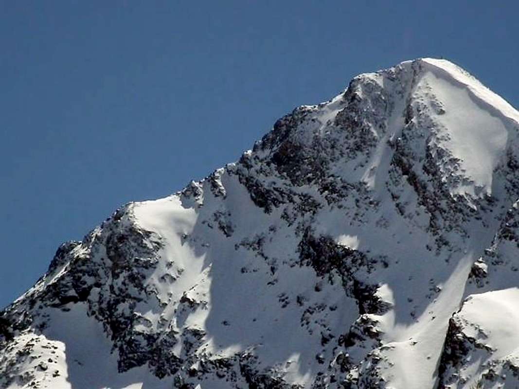
The History of the winter ascents to this top is rather short, as besides for all the peaks not only of the GROUP of the Gran Paradiso in strict sense (up to the Hill of the Arietta as in the Guide C.A.I./T.C.I. "Gran Paradiso", Editions 1939, 1963 and 1980) or broadly speaking (Subgroups of Emilius-Tersiva-Delà-Glacier-Rouvic and Avic-Rosa of the Banchi as in Guida C.A.I./T.C.I. "Emilius Rosa dei Banchi Parco del M. Avic", Edition 2005), but also for all the other mountains on the right hydrographical (South) of the River Dora Baltea from Courmayeur to Pont Saint Martin, Valleys of Cogne and included Champorcher. Long accesses, fatiguing and at times dangerous they rather limit the of it "traffic" reducing of very the winter share of the mountain climber, almost only revolt to some classical inherent the Ski-mountaineering. These observations are worth besides for the Emilius, as the Tersiva climbed in little winter more than a half dozen of times, while other surrounding peaks still know an inferior number of winter and someone still attends the first slope in the bad season. I know sporadic it is the presence of the lovers of the mountain, that leaves also burdens voids not to say of the "holes" for those people who wanted to effect to serious search of it; scarce the bibliography difficult and rather the search of the dates. So much that Mario Aldrovandi was convinced, with his wife and the Guide Joseph Vassoney, to have effected the first winter some mountain in distant January of 1930. Instead he had been preoperating of something as 55anni (him, proper about fiftyfive) from Joseph Corona and his Party the 17 of February 1875 (the same had also effected the first winter crossing of the Pass of Saint Marcel from Cogne to this last place, so much that the hill also brings its name or Hill Corona's, where, to our notice, that them it plays as genitive Saxon, or Hill of Corona). Then the void, at least for how much he is given to know, for 55 seasons; empty surely real otherwise the Aldrovandi, before proclaiming as before his winter, he would have thought of us for a small moment. Instead no: the ascension of the Giuseppe Corona escaped him, as from the "Alpinista 1875/77", pag. 106 and from the "Bulletin C.A.I. 1903/69", to the page 15. Also the "Book of Peak of the Tersiva 1921-74" confirm these observations, anymore burdens winter ascension not resulting or, if effected, he has not been transcribed in the same one. But in this space of time, or between the first winter and the 1930 second, something connected, if not really to the winter as considered tradiziolmente but at least next to the same one, he was happened with the first ascension with the skis from Aldo Bonacossa and Companions in the 1921 Spring, as it results in the book of the same. It will need to attend the 25 April of 1942 to find some novelties with the crossing through ski from the Valley of Cogne to that of Fénis/Clavalité, through the Hill of the Tersiva, from Toni Ortelli and some component ones of the Ski Club Turin. But also always in Spring, even if he can be annotated as the snowy conditions of the mountain is changed within one century around, with the conspicuous and progressive reduction of the mantle, so much that the Wall North-northeast from completely glacial he is turned into a mixed face with great snowcapped to form of funnel, interposed more and more by thick and evident rocky bands, and that Northwest from mixed he is reduced to almost pure rocky wall. And it has to spend another half century demanded for finding again, really on her before these, of the winter ascensions with two different routes effected by the Guide of Valpelline Maurice Gaillard also called "Maurizietto" in the end of December 1980 and in beginning 1984, always together with Sergio Pession. Other ski-alpine ascensions result at the end of the Seventies from the same with mountain climbers "Fénisani" and in the last thirty-year period from the "Cognensi"; but all revolts to the late Spring. In the most greater detail to see the chapter "Tersiva Winter" in the page "ALL ROUTES (20 + 1 historical) OF PUNTA TERSIVA")
La Storia delle ascensioni invernali a questa cima é alquanto limitata, come daltronde per tutte le vette non solo del Gruppo del Gran Paradiso in senso stretto (fino al Colle dell'Arietta come nella Guida C.A.I./T.C.I. "Gran Paradiso", Edizioni 1939, 1963 e 1980) o lato (Sottogruppi di Emilius-Tersiva-Delà-Glacier-Rouvic ed Avic-Rosa dei Banchi come in Guida C.A.I./T.C.I. "Emilius Rosa dei Banchi Parco del M. Avic", Edizione 2005), ma anche per tutte le altre montagne sulla destra idrografica (Sud) del Fiume Dora Baltea da Courmayeur a Pont Saint Martin, Valli di Cogne e Champorcher incluse. Accessi lunghi, faticosi nonché a volte pericolosi ne limitano alquanto il "traffico" riducendo di molto la partecipazione invernale degli alpinisti, quasi solamente rivolta ad alcune classiche inerenti lo Sci-Alpinismo. Queste osservazioni valgono inoltre per l'Emilius, come la Tersiva saliti in inverno poco più di una mezza dozzina di volte, mentre altre vette circostanti conoscono un numero ancora inferiore di invernali e qualcuna attende ancora la prima salita nella cattiva stagione. Talmente sporadica è la presenza degli amanti della montagna, che lascia anche dei vuoti per non dire dei "buchi" per coloro che ne volessero effettuare una seria ricerca; scarsa la bibliografia ed alquanto difficile la ricerca dei dati. Tanto che Mario Aldrovandi era convinto, con la moglie e la Guida Giuseppe Vassoney, di aver effettuato la prima invernale del monte nel lontano Gennaio del 1930. Invece era stato anticipato di qualcosa come 55anni (si, proprio cinquantacinque) da Giuseppe Corona e la sua Comitiva il 17 di Febbraio 1875 (lo stesso aveva effettuato anche la prima traversata invernale del Colle di Saint Marcel da Cogne a quest'ultima località, tanto che il colle porta anche il suo nome o Colle Coronas, dove, a nostro avviso, quella esse suona come genitivo sassone, ovvero Colle di Corona). Poi il nulla, almeno per quanto é dato a sapere, per 55 stagioni; vuoto sicuramente effettivo altrimenti l'Aldrovandi, prima di proclamare la sua come prima invernale, ci avrebbe pensato per un momentino. Invece no: gli sfuggiva l'ascensione del Corona, come da l'"Alpinista 1875/77", pag. 106 e dal "Bollettino C.A.I. 1903/69", alla pagina 15. Anche il "Libro di Vetta della Tersiva 1921-74" conferma quest'osservazioni, non risultando più alcuna ascensione invernale oppure, se effettuata, non é stata trascritta nel medesimo. Ma in questo spazio di tempo, ovvero tra la prima invernale e la seconda del '30, qualcosa di attinente, se non proprio all'inverno come tradizionalmente considerato ma almeno viciniore al medesimo, era accaduto con la prima ascensione con gli sci da parte di Aldo Bonacossa e Compagni nella Primavera del 1921, come risulta nel libro dello stesso. Bisognerà attendere il 25 Aprile del 1942 per riscontrare qualche novità con la traversata tramite sci dalla Valle di Cogne a quella di Fénis/Clavalité, attraverso il Colle della Tersiva, da parte di Toni Ortelli ed alcuni componenti dello Ski Club Torino. Ma pur sempre in Primavera, anche se si può annotare come siano cambiate le condizioni nevose della montagna nell'arco di un secolo circa, con la riduzione cospicua e progressiva del manto, tanto che la Parete Nord-nordest da completamente glaciale si é trasformata in una faccia mista con grandi nevati a forma di imbuto, inframmezzati da fasce rocciose sempre più spesse ed evidenti, mentre quella Nordovest da mista si é ridotta a quasi pura parete rocciosa. E deve passare un altro mezzo secolo esatto per ritrovare, proprio sulla prima di queste, delle ascensioni invernali con due vie diverse effettuate dalla Guida di Valpelline Maurice Gaillard "Maurizietto" nel fine di Dicembre 1980 ed in inizio 1984, sempre insieme all'amico Sergio Pession. Altre ascensioni sci-alpinistiche risultano alla fine degli Anni Settanta da parte dello stesso con alpinisti "Fénisani" e nell'ultimo trentennio da parte dei "Cognensi"; ma tutte rivolte alla tarda Primavera. Nel maggior dettaglio vedere il capitolo "ALL ROUTES (20 + 1 historical) OF PUNTA TERSIVA") sempre in SP.
Various Anecdotes
VARIOUS ANEDOCTES - 1): WHEN A CIGARETTE SAVES YOUR LIFE
The crossing of the Glacier of the Tessonet in his underlying tall part the Wall Northwest of the Tersiva is simple and, after the descent from the Shuts = great and long rocky ridge) Madù (not simple if in "verglass" and at times is of it that the have seen her equip by the Guides of Cogne), and even too much fatiguing, since the run to go himself at basic the of the Hill of the Tersiva almost results in false level. But it is more untrustworthy than you are thought; not so much for the crevasses, on the contrary for the frequent discharges that originate from the overhanging wall, thing that the signs of the same ones on the ice they underline in clear way. Then the crossing becomes fatiguing, because it is worthwhile to almost effect it of run for all the 600 meters of width of the same one. To the necessity The wants to tell you to lived episode: it is the 5 of August of 1998, when with Emilio Bertona alias Emilius, the Judge of Cassation Nicola Colajanni, the Headmaster Gianfranco Vicentini, the Teacher Silvana Quendoz and her "Nanda" Carrel we go down from the Tersiva to the homonym pass and from this to his basic on the Glacier of the Tessonet; before to begin the crossing back I have a big desire to smoke a cigarette. But the don'ts have of dark, it with great joy of all the other "virtuous" of the rope. What "to break s.o.'s balls!" Another rope arrives to which address me in help, but the only smoker tells me to also have ended her him. However, if I want to wait, he can make me a cigarette manufacturing it with paper and tobacco. Among the protests of mine "virtuous" I accept and I attend; so much without me they don't depart. It begins the ritual, but after few minutes a boom shakes the mountain forcing us to lift the head: a block of great rock as a TIR falls from the Wall Northwest, it breaks him in two as it was a truck with its towing. Then in four for then to disintegrate himself flying above the glacier, really where we would have had to pass. At that time precise. Emilio, from big photographer, he succeeds in still "shooting" a great block as a car that flies in form of shark delineating itself against the sky. Dismay and absolute silence … To memory of Headmaster and 14 years of distance, "the Gianfranco" remembered me as her "bomb", as 10 brooms were exploded, simultaneously it reached grazing us to us with fragments of splinters and that the same ones had come up to us from a distance of over 200 meters! All thank Osw, "THE SMOKER!".

ANEDDOTI VARI - 1): QUANDO UNA SIGARETTA TI SALVA LA VITA
L'attraversamento del Ghiacciaio del Tessonet nella sua parte alta sottostante la Parete Nordovest della Tersiva è piuttosto semplice e, dopo la discesa dalla Serra Madù (non sempre facile se in "verglass" tanto ne è che l'ho vista attrezzare dalle Guide Cognensi), e neppur troppo faticosa, poiché il percorso per portarsi alla base del Colle della Tersiva risulta quasi in falsopiano. Ma è più infido di quanto non lo si pensi; non tanto per i crepacci, bensì per le frequenti scariche provenienti dalla soprastante parete, cosa che i segni delle medesime sul ghiaccio evidenziano in modo palese. Allora la traversata diventa faticosa, perché conviene effettuarla quasi di corsa per tutti i 600 metri di larghezza del medesimo. All'uopo voglio raccontarvi un episodio vissuto: è il 5 di Agosto del 1998, quando con Emilio Bertona alias Emilius, il Giudice di Cassazione Nicola Colajanni, il Preside Gianfranco Vicentini, la Professoressa Silvana Quendoz e la "Nanda" Carrel scendiamo dalla Tersiva al colle omonimo e da questo alla sua base sul Ghiacciaio del Tessonet; prima di intrapprendere la traversata di ritorno ho una gran voglia di fumare una sigaretta. Ma non ne ho più, con grande gioia di tutti gli altri "virtuosi" della cordata. Che "scassa balle"! Sopraggiunge un'altra cordata alla quale mi rivolgo in aiuto, ma l'unico fumatore mi dice di averle finite pure lui. Però, se voglio aspettare, mi può fare una sigaretta confezionandola con carta e tabacco. Tra le proteste dei miei "virtuosi" accetto ed attendo; tant'é che senza di me non partono. Inizia il rituale, ma dopo pochi minuti un boato scuote la montagna obbligandoci ad alzare la testa: un blocco di roccia grande come un TIR precipita dalla Parete Nordovest, si spezza in due come fosse un camion con il suo rimorchio. Poi in quattro per in seguito disintegrarsi volando sopra il ghiacciaio, proprio dove noi avremmo dovuto passare. In quel momento preciso. Emilio, da gran fotografo, riesce a riprendere ancora un blocco grande come un'automobile che vola in forma di squalo delineandosi contro il cielo. Costernazione e silenzio assoluto … A memoria di Preside ed a 14 anni di distanza, "il Gianfranco" mi ricordava come la "bomba", come fossero esplose simultaneamente 10 granate, ci raggiunse sfiorandoci con frammenti di schegge e che i medesimi fossero giunti fino a noi da una distanza di oltre 200 metri! Tutti ringraziano Osw, "IL FUMATORE!"
 |
 |
 |
 |
 |
VARIOUS ANECDOTES - 2): AND THEY SAID THAT FROM THE TERSIVA THE SEA CAN BE SEEN
They said that from the Point Tersiva the Sea Khan be seen. The Ligure Sea, looking to make southeast (you see Mario Aldrovandi in "Guides of the Region Autonoma of the Valley of Aosta" 1930/2 and 1964, in page 289: "From the Tersiva, in the clear days, the sea Khan be seen." Others as Giovanni Bobba and Luigi Vaccarone in "Guide of the Alps Occidentali-Vol. II. Graie and Pennine SECOND PART Her Valleys of Aosta, of Biella, of the Sesia and of the Ossola", Edit. Section of the C.A.I. of Turin of May 25 th 1896, pages 65/6, perceived you new marvels: "The panorama that is perceived by this elegant and quick pyramid, that rises well isolated by every side, is one of the most famous of the Valley of Aosta; it is in rivalry with that some Emilius Mountain, superior perhaps this last as view on the entourage of the Pennines, inferior certainly if you are considered that not the Alps are perceived only by the Tersiva, but also wide part of the lowland Padana, ploughed by sparkling rivers. It purchases a greater variety of it, wide remuneration to whoever it completes the ascension." And besides Giulio Berutto (+) and Lino Fornelli into a very famous Necklace C.A.I./T.C.I. Guide of the Mountains of Italy "Emilius Rosa of the Banchi Park of the M. Avic", Edit. March 2005, to the page 156: "Famous his panorama that understands a pò all the peaks "valdostane" and ample zones of the Western Alps." Dark prudent instead the judgment of Pietro Giglio author together with Nemo Canetta, Andrew Parodi, Lawrence Barbié and Peter Carlesi on "Le Guide di Alp Grandi Monti/1 Piemonet Valle d'Aosta Lombardia" also in English "The Guides of Alp Great Mounts/1 Piedmont Valley of Aosta Lombardy", Vivalda Publishers SPA Year III number 1 Summer 1989, where to page 87 in "The Mountain of Light Point Tersiva from Gimillan", affirms that seems that burdens mountain climber, in clear days, has seen it to naked eye. But the affirmation rather results hypothetical and certain sources are not quoted, even bibliographical. And however its opinion remains doubtful rather about it. But in the various personal ascensions I have never seen neither the sea, neither the sparkling and silvery rivers and not even the great Tableland of Stream Pò's into the Lowlands. To little for the bad found time; other times for the hurry and other again because The don'ts have really seen these you marvel. Even in the Tower of Lavina (3.308m), from the Great Arolla (3.248m), from the Gran San Pietro (3.692m) or from the Roccia Viva (3.650m), you position more next to Southeast and Southwest. Nothing also from the Sum Summit of the Granpa (4.061m), Maximum Peak of the Chain to which it gives the name and of all the Graian Alps, logically Chain of the Mount Blanc excluded. But then is not true! Or the Ligure Sea and the Lowland Padanas don't exist or they have disappeared, as Atlantide? Last hypothesis that I am, if not blind, surely a little I bereave. But is this sight of the Ligure Sea from the Summit of the Point of the Tersiva as the ARAB PHOENIX by Metastasio then: "Everybody says that is, where is anybody he knows it" ??? ... But the 5 of January of 1975 the busillis is definitely resolved thanks to a partial use and a not properly orthodox use of the transitive ownership of the equality: from the Peak of the Emilius, of scarce about fifty meters more elevated but lined up on the same directive of view, in a cold day and of very clear sky, on the Southeast right THE SEA appears with its slim tones that float among a small fog, while in opposite sense toward West the South Wall of the Tofana of Rozes hacks him, with middle profile, yellowish and unmistakable to more than 700 Kilometers among the Dolomites!! And are in four testify to see!!!.
*** a) - from an excerpt, here under brought, of the "Libro of the Tersiva 1921/74" (see besides always in SP the chapter "The UNBELIEVABLE Doctor "Ansel" FALCOZ" in the page "Folklore & Funny Histories & Tales between "Becca" & Emilius & Alentours"): Doctor Falcoz was a mountain climber I accustom to these great enterprises of endurance. Memory of one story of his, to the times of the layout of the "Guide of the Emilius Mountain" in 1978, where it narrated me of one slope of his to the Dent Blanche (4.357m) in Vallais through the Crest of the Four Donkeys with departure in bicycle (him, those very heavy of the thirties with the brakes to piston) and return, after the ascension, always through the Footstep of the Great St. Bernard (2.473m). Very hard test for true strong men! He could be reassumed in this way, as done synthesize in the document: 26 July of 1930 (?) departure from his own house in the place Fernier (1.778m; near the homonym Torrent in the Western side of the Basin of Pila), Pila-Pos, Lake and Hill of Chamolé (2.325m and 2.641m), Alp and Lake of Arbole (2.516m and 2.499m) with run of the homonym Walloon up to alternative the 2.600 meters around for the Hill Garin among the ancient refuges of the Bareques des Pouleins and of Modzon (rests and ruins), moraine at basic the of the Pas du Valaisan (3.210m) and crossing of the Hill upward "Vallone" of Lussert/Grauson and slope to the Tour Grauson through right side of the Wall North and West Crest in the final line. Descent same street on the rests of the ancient Glacier of Lussert and pursuance up to the Farms Peccoz (? You should correspond or to an old pasture near the actual one of Grauson Nuove or to the underlying one of Pralognan, to confirmation that the Reserve of the Baron Beck Peccoz in that times also extended him to the Valley of Cogne, trespassing over that of Saint Marcel and the Vallons of the Laures and the Arpisson) for the overnight stay. 27 July of 1930 (?): departure for the Point Tersiva reaching the Alpage of Ervillères or Erveilleres (2.515m), gone up again nearby the homonym Ru (= Torrent) along the Tessonet/Doreire longe Valley up to the Tessonet Glacier, Hill of the Tersiva (3.310m) and Peak through the Crest North-northwest. I return in day to Fernier for the identical route. A test of other times, for tempered men and worthy of the first mountaineering '800 classical post.
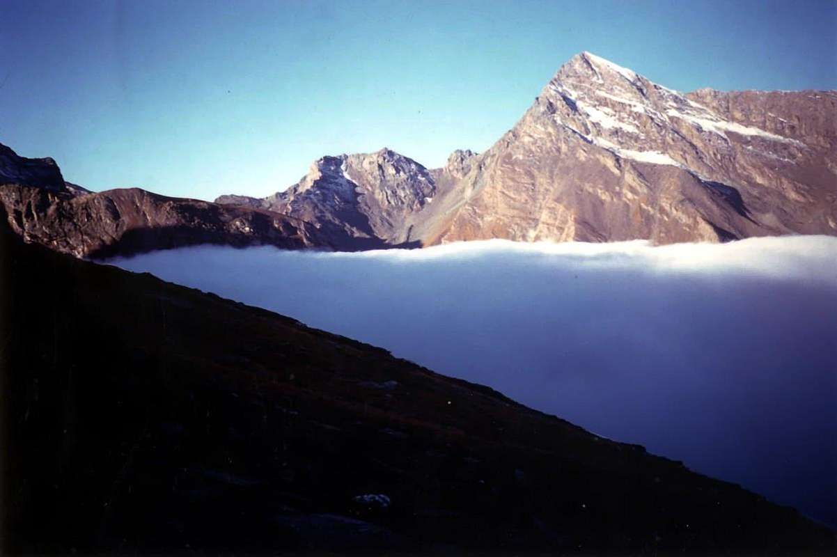 |
ANEDDOTI VARI - 2): E DICEAN CHE DALLA TERSIVA POTEASI VEDER IL MAR
Dicevan che dalla Punta Tersiva si può vedere il Mare. Il Mar Ligure, guardando in grande lontananza al Sudest (vedi Mario Aldrovandi in "Guida della Regione Autonoma della Valle d'Aosta" 1930/2 e 1964, in pagina 289: "Dalla Tersiva, nelle giornate limpide, si può vedere il mare." Altri, come Giovanni Bobba e Luigi Vaccarone in "Guida delle Alpi Occidentali – Vol. II. Graie e Pennine PARTE SECONDA Le Valli di Aosta, di Biella, della Sesia e dell'Ossola", Edit. Sezione del C.A.I. di Torino del 25 maggio 1896, pagine 65/6, vi osservavan nuove meraviglie: "Il panorama che si scorge da questa elegante e svelta piramide, che sorge ben isolata da ogni lato, é uno dei più rinomati della Valle d'Aosta; esso rivaleggia con quello del Monte Emilius, superiore forse quest'ultimo come veduta sulla cerchia delle Pennine, inferiore certamente se si consideri che non soltanto le Alpi si scorgono dalla Tersiva, ma anche larga parte della pianura padana, solcata da fiumi scintillanti. Ne acquista una maggior varietà, largo compenso a chiunque compie l'ascensione.". Ed inoltre Giulio Berutto (+) e Lino Fornelli nella celeberrima Collana C.A.I./T.C.I. Guida dei Monti d'Italia "Emilius Rosa dei Banchi Parco del M. Avic", Edit. Marzo 2005, alla pagina 156: "Famoso il suo panorama che comprende un pò tutte le vette valdostane e ampie zone delle Alpi Occidentali." Più prudente invece il giudizio di Pietro Giglio autore insieme a Nemo Canetta, Andrea Parodi, Lorenzo Barbié e Piero Carlesi in "Le Guide di Alp Grandi Monti/1 Piemonte Valle d'Aosta Lombardia", Vivalda Editori SPA Anno III numero 1 Estate 1989, ove a pagina 87 in "La Montagna di Luce Punta Tersiva da Gimillan", riporta che par che qualche alpinista, in giornate limpide, l'abbia visto ad occhio nudo. Ma l'affermazione risulta alquanto ipotetica e non vengono citate fonti certe, neppure bibliografiche. E comunque il suo parere rimane alquanto dubitativo in tal merito. Ma nelle varie ascensioni personali non ho mai scorto né il mar, né i scintillanti ed argentei fiumi e neppure la grande Piana del Po. Un pò per il cattivo tempo riscontrato; altre volte per la fretta ed altr'ancora perché non ho proprio visto siffatte meraviglie. Neanche dalla Torre di Lavina (3.308 m), dalla Grande Arolla (3.248 m), dal Gran San Pietro (3.692 m) o dalla Roccia Viva (3.650 m), posizionate più vicino a Sudest e Sudovest. Nulla anche dalla Somma Sommità del Granpa (4.061 m), Vetta Massima della Catena alla quale dà il nome e di tutte le Alpi Graie, logicamente Catena del Monte Bianco esclusa. Ma allora non é vero! Oppure il Mar Ligure e la Piana Padana non esistono o son scomparsi, come Atlantide? Ultima ipotesi ch'io sia, se non cieco, sicuramente un pochettin'orbo. Ma allora questa vista del Mare Ligure dalla Sommità della Punta della Tersiva é come l'ARABA FENICE del Metastasio: "Tutti dicon che vi sia, ove sia nessuno lo sa" ??? ... Ma il 5 di Gennaio del 1975 il busillis é definitivamente sciolto grazie ad un parzial uso e non del tutto ortodosso utilizzo della proprietà transitiva dell'uguaglianza: dalla Vetta dell'Emilius, di una scarsa cinquantina di metri più elevato ma allineato sulla medesima direttiva di visuale, in una giornata fredda e di cielo tersissimo, sulla destra a Sudest appare IL MARE con le sue tenue sfumature che galleggiano tra una finissima nebbiolina, mentre in senso opposto verso Occidente la Parete Sud della Tofana di Rozes si staglia, di mezzo profilo, giallognola ed inconfondibile a più di 700 Kilometri tra le Dolomiti!! E siamo in quattro testimoni a vedere!!!.
VARIOUS ANEDOCTES - 3): ENORMOUS & TITANIC ENTERPRISES OR THE TERSIVA FROM VERY GREAT DISTANCES The sporting performances found above him at least three physical abilities of base: the Resistance, the Strength and the Speed with various integrations and correlations among the same ones; in reality they don't exist, since for road you will never meet it Mrs. Resistance, the Girl Speed and not even the Mr. Strength. I am an artificial classification to frame better a typology of sporting discipline, but in the same one these conditional abilities (because they condition the performance) they come to also intend simultaneously themselves if with different percentages; that's why for instance the 100 plain meters are considered the test for excellence of the pure speed, or the lifting weighs (weight lifting) that of the strength and the marathon as the queen of the resistance. But in each of it they are implicit also the others two and to be resistant needs to also have a certain muscular strength and at the same time to proceed with a certain speed. This brief preamble with the purpose to be able to talk of the slopes to the Point Tersiva from great distances, for what we know, quoting three to be able to make its correct conceives of The forces it employee and without to consider the factor time postponing it same to the superficial differentiation between morning and evening or from day to day. For the occasion you are considered an ascension of the Thirties from the Doctor "Ansel" Falcoz and two "personal" of the Seventies finish the one with a success and the other with a failure. b) - from the "Alpine Diaries 1964-2012", by Osvaldo Cardellina in date July 13 th 1971: combination of the slope to the Emilius Mountain with Pila Resort departure for the route of the Hill Plan de Fenetre, climbed to Becca di Nona, come down to the Hill Carrel, Western and Oriental crossing of the two Glaciers of Arpisson, climbed to the Head Blantsette (3.142m) and crossing through the crest to the homonym Collar (3.126m) and from this on the Glacier Blantsette at the base of the East Wall of the Emilius with descent, through the steep moraine, to the Inferior Lake of the Laures and overnight stay to the Shelter Innocenzo Ménabreaz. The day later gone up again to the Pass of the Three Capuchins (3.242m) and along the Crest South-southeast ascension of the Emilius Mountain; come down the same West trickery of the following Point of Three Capuchins or Quota 3.283/4m reaching the Hill of Arbolle (3.154m), to the beginning of the Crest Northeast of the Red Point of the Emilius. Here our roads diverge: me, fresh of wedding, I return home for the street of the before deep and after wide of Arbolle and completing so the "Turn of the Emilius." Marco Cossard alias "Crevassino", inventor of these marathons, instead together with Joseph Lamazzi, Franco Lenzi and Ezio Trussoni they go down in the "Vallone" of the Laures, tall part, and they cross to the homonym Hill (3.035/6m); come down in the Valley of the Grauson/Lussert passing for the three lakes to reach Grauson Nuove Pasture. Crossed in quota, without going down to the Alpe of Pralognan, to reach that of Erveilleres Pastures (2.515m) for the bivouac, that the very equipped with pots and small pans "Crevassino" it cheers with a good "pasta seasoned" by the squeezing of a small pipe of "tomatico" (= tomato sauce; a regret for the whole life for the absentees!). On July 15 departure for the Tersiva on the Glacier of the Tessonet toward l'homonym collar and Crest North-northwest and relative descent for the long "Vallone" Doreire/Grauson up to the Village of Gimillan (1.788m) and Cogne little Town (1.534m), from where by bus to Aosta and again Pila Basin operated to recover the car! A trek forerunner of this discipline then not yet in great top and however always binding also currently.
*** a) - da uno stralcio, qui sopra riportato, dal "Libro della Tersiva 1921/74" (vedi inoltre "sempre in SP il capitolo "The UNBELIEVABLE Doctor "Ansel" FALCOZ" nella pagina "Folklore & Funny Histories & Tales between "Becca" & Emilius & Alentours"): il Dottor Falcoz era un'alpinista avvezzo a queste grandi imprese di endurance. Ricordo di un suo racconto, ai tempi della stesura della "Guida del Monte Emilius" nel 1978, dove mi narrò di una sua salita alla Dent Blanche (4.357 m) nel Vallese attraverso la Cresta dei Quattro Asini con partenza in bicicletta (si, quelle molto pesanti degli anni trenta con i freni a stantuffo) e ritorno, dopo l'ascensione, sempre attraverso il Passo del Gran San Bernardo (2.473 m). Prova durissima per veri uomini duri! Si potrebbe riassumere in siffatta maniera, come sintetizzato nel documento: 26 Luglio del 1930 (?) partenza dalla propria casa in località Fernier (1.778 m; presso l’omonimo Torrent nel lato Occidentale della Conca di Pila), Pila-Pos, Lago e Colle di Chamolé (2.325 m e 2.641 m), Alpe e Lago di Arbole (2.516 m e 2.499 m) con percorso dell'omonimo Vallone fino al bivio 2.600 metri circa per il Colle Garin tra gli antichi ricoveri delle Bareques des Pouleins e di Modzon (resti e rovine), morena alla base del Pas du Valaisan (3.210 m) e traversata del Colle verso l'Alto Vallone di Lussert/Grauson e salita alla Tour Grauson tramite lato destro della Parete Nord e Cresta Ovest nel tratto finale. Discesa stessa via sui resti dell'Antico Ghiacciaio di Lussert e proseguimento fino ai Casolari Peccoz (? Dovrebbero corrispondere o ad una vecchia alpe presso l'attuale di Grauson Nuove oppure alla sottostante di Pralognan, a conferma che la Riserva del Barone Beck Peccoz in quei tempi si estendeva anche alla Valle di Cogne, sconfinando oltre quella di Saint Marcel ed i Valloni delle Laures e dell'Arpisson) per il pernottamento. 27 Luglio del 1930 (?): partenza per la Punta Tersiva raggiungendo l'Alpeggio di Ervillères o Erveilleres (2.515 m), risalita presso l'omonimo Ru lungo il Vallone Tessonet/Doreire fino al Ghiacciaio del Tessonet, Colle della Tersiva (3.310 m) e Vetta tramite la Cresta Nord-nordovest. Ritorno in giornata a Fernier per l'identica via. Una prova di altri tempi, per uomini temprati e degna del primo alpinismo post classico dell'800.
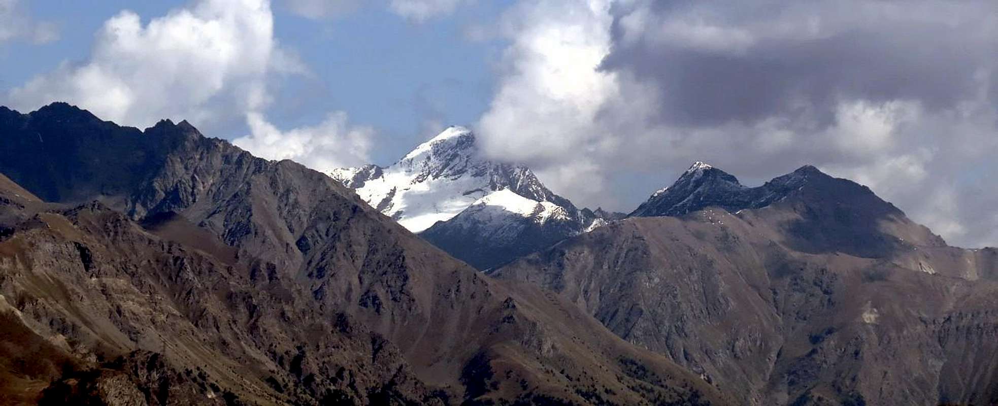 |
c) - from the "Alpine Diaries 1964-2012", of Osvaldo Cardellina in dates June 29th 1973: as usual with "Crevassino" he goes to the total adventure without preset destination or at least with an conceives of initial run that comes then, generally casually, always and rather modified; for the what thing they as out from there great soups and, as in this houses, of the beautiful omelets. You departs, for going to effect the Fires of Peter and Paul on the Peak of the Emilius (3.559m), even among the Village of Tall Les Druges (1.594m) and the Alp Pouria (1.586m) in the Valley of Saint Marcel. Gone up again of the Reserve Marquis Turati to the Houses of Hunting of Mulac-Saint Louis (1.937m) and of Grande Chaux (2.370m); gone up again to the Hill Corona or of Saint Marcel (2.918m). Here to the "Crevassino" a detour comes to mind toward the Tersiva: along the crest watershed we salt to the two Points of Laval (3.091m and 3.101m), to the following Point Gianni Vert (3148m); then, looking above the Pass of Tessonet (3.062m), the homonym Point and Coastline and the distant Tersiva, have an afterthought. He returns back, because to the "Crevassino" the exposed ridges and sharp they don't like really. But unhealthy idea doesn't finish here: bypass of the Mont Vallonet (3.098m) and descent to the homonym Hill (3.062m), climbed to the Point of Leppe (3.305m), come down on its snowy Slope Northwest to a small saddle 3.181 meters and slope to the Quota 3.221 meters or Point of Lussert, further come down by the steep Wall South of broken rocks of this last reaching the Inferior Lake of Lussert (2.721m). You starts over climbing toward the Middle Lake (2.800m) and then that Superior (2.907m); therefore he goes to the Col des Laures (3.036m) passing therefore in the third vallon of the day. Crossing at the base of the East Wall of the Red Point, on a fatiguing and boring moraine of great reddish and sharp blocks, and gone up again to the Hill of Arbolle (3.154m) and entry in the quarter or Vallon of Arbolle. Revolving the Point of Three Western Capuchins we reach the homonym pass. Here the débacle happens: at first it stops him the "Crevassino", that has ended the gasoline, then "burst" me (I have beaten at night with the typewriter up to the three my thesis of degree for the I.S.E.F. and we have departed at five o'clock) and as soon as more aloft on the Crest S-SE, with the dark that catches him discouraging him, it also arrests him the "Peppino". For this year the fires them we can forget. Who wants too much nothing it tightens (Italian proverb)! ... But the adventure is not ended still. The epilogue of this long done race by true camels? To the complete dark we go down to camp out on the Southern bank of the Frozen Lake (2.957m), where we find shelter under a small rocky plate; throwing us above the only cover in our possession (we have neither duvet nor least of all sack to hair) we allow us to have been winding for the cold and starry night. The shivers increase with to spend some times. But in too exaggerated way. To the awakening to the dawn we don't find the anymore "Crevassino": slipped in low of about ten meters, sleeps & snores candidly blissfully wound by it "his" covered. Ah! Go to trust the Friends!!! Finally the long, weary and endless descent to the Fraction of Plan Felina (659m; near the City of Aosta) through the Walloons of Arbolle, Comboé and of the Dard, where the "our" it is object of an endless series of deserved insults. And the recovery of the car to Tall Les Druges? Mystery of the mysteries of "Crevassino"!!!.
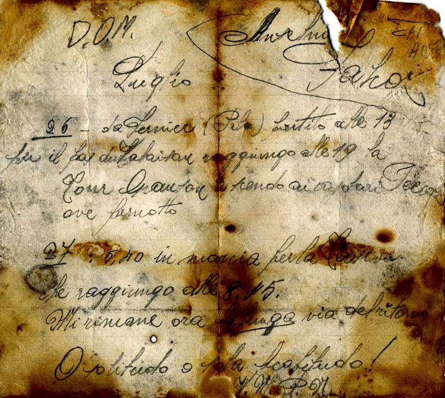 |
ANEDDOTI VARI - 3): IMPRESE TITANICHE E STRATOSFERICHE, OVVERO LA TERSIVA DA GRANDISSIME DISTANZE
Le prestazioni sportive si basano su almeno tre capacità fisiche di base: la Resistenza, la Forza e la Velocità con varie integrazioni e correlazioni tra le medesime; in realtà non esistono, poiché per strada non incontrerete mai la Signora Resistenza, la Signorina Velocità e neppure il Signor Forza. Sono una classificazione artificiale atta ad inquadrare meglio una tipologia di disciplina sportiva, ma nella stessa queste capacità condizionali (perché condizionano la prestazione) vengono a proporsi simultaneamente pur se con percentuali diverse; ecco perchè ad esempio i 100 metri piani sono considerati la prova per eccellenza della velocità pura, oppure il sollevamento pesi (pesistica) quello della forza e la maratona come la regina della resistenza. Ma in ognuna di essa sono implicite anche le altre due e per essere resistenti bisogna avere anche una certa forza muscolare ed allo stesso tempo procedere con una certa velocità. Questo breve preambolo al fine di poter parlare delle salite alla Punta Tersiva da grandi distanze, per ciò che noi conosciamo, citandone tre per poter render la giusta idea dello sforzo impiegato e senza tener dacconto il fattore tempo rimandando lo stesso alla differenziazione semplicistica tra mattino e sera o da giorno a giorno. Per l'occasione vengono prese in considerazione un'ascensione degli Anni Trenta da parte del Dottor "Ansel" Falcoz e due "personali" degli Anni Settanta terminate l'una con un successo e l'altra con un fallimento.
b) - dai "Diari Alpinistici 1964-2012", di Osvaldo Cardellina in data 13 Luglio 1971: combinazione della salita al Monte Emilius con partenza da Pila per la via del Colle Plan de Fenetre, salita alla Becca di Nona, discesa al Colle Carrel, attraversamento dei due Ghiacciai Occidentale ed Orientale dell'Arpisson, salita alla Testa Blantsette (3.142 m) e traversata in cresta all'omonimo Colletto (3.126 m) e da questi sul Ghiacciaio Blantsette alla base della Parete Est dell'Emilius con discesa, tramite la ripida morena, al Lago Inferiore delle Laures e pernottamento al Rifugio Innocenzo Ménabreaz. Il giorno appresso risalita al Passo dei Tre Cappuccini (3.242 m) e lungo la Cresta Sud-sudest ascensione del Monte Emilius; discesa della medesima con successivo aggiramento ad Ovest della Punta dei Tre Cappuccini o Quota 3.283/4 m raggiungendo il Colle di Arbolle (3.154 m), all'inizio della Cresta Nordest della Punta Rossa dell'Emilius. Qui le nostre strade divergono: io, fresco di nozze, torno a casa per la via del Vallone di Arbolle e compiendo così il "Giro dell'Emilius". Marco Cossard alias "Crevassino", ideatore di queste maratone, invece insieme a Giuseppe Lamazzi, Franco Lenzi ed Ezio Trussoni scendono nel Vallone delle Laures, parte alta, ed attraversano al Colle omonimo (3.035/6 m); discesa nel Vallone del Grauson/Lussert passando per i tre laghi per raggiungere l'Alpeggio di Grauson Nuove. Traversata in quota, senza scendere all'Alpe di Pralognan, per raggiungere quella di Erveilleres (2.515 m) per il pernottamento, che il molto attrezzato con pentole e pentoline e pentolame vario "Crevassino" allieta con una buona pastasciutta condita dalla spremitura di un piccolo tubo di tomatico (un rimpianto per tutta la vita per gli assenti!). Il 15 Luglio partenza per la Tersiva sul Ghiacciaio del Tessonet verso l'omonimo colletto e Cresta Nord-nordovest nonché relativa discesa per il lungo Vallone Doreire/Grauson fino al Villaggio di Gimillan (1.788 m) ed il Centro Turistico di Cogne (1.534 m), donde tramite corriera ad Aosta e nuovamente a Pila per recuperare l'auto! Un trek antesignano di questa disciplina allora non ancora in grande auge e comunque sempre impegnativo anche attualmente.
 |
 |
c) - dai "Diari Alpinistici 1964-2012", di Osvaldo Cardellina in data 29 Giugno 1973: come al solito con "Crevassino" si va all'avventura totale senza meta prefissata od almeno con un'idea di percorso iniziale che poi viene, in genere casualmente, sempre ed alquanto modificata; per la qual cosa ne vengono fuori minestroni e, come in questo caso, delle belle frittate. Si parte, per andare ad effettuare i Fuochi di Pietro e Paolo sulla Vetta dell'Emilius (3.559 m), addirittura tra il Villaggio di Les Druges Alte (1.594 m) e l'Alpe Pouria (1.586 m) nella Valle di Saint Marcel. Risalita della Riserva Marchese Turati alle Case di Caccia di Mulac-Saint Louis (1.937 m) e di Grande Chaux (2.370 m); risalita al Colle Corona o di Saint Marcel (2.918 m). Qui al "Crevassino" viene in mente una digressione verso la Tersiva: lungo la cresta spartiacque saliamo alle due Punte di Laval (3091 m e 3.101 m), alla successiva Punta Gianni Vert (3.148 m); poi, guardando sopra il Colle Tessonet (3.062 m), le omonime Punta e Costa e la lontana Tersiva, ha un ripensamento. Si torna indietro, perché al "Crevassino" le creste esposte ed affilate non attraggono proprio. Ma l'idea malsana non termina qui: scavalcamento del Mont Vallonet (3.098 m) e discesa all'omonimo Colle (3.062 m), salita alla Punta di Leppe (3.305 m), discesa sul suo innevato Versante Nordovest ad una piccola sella 3.181 metri e salita alla Quota 3.221 metri o Punta di Lussert, ulteriore discesa dalla ripida Parete Sud di rocce rotte di quest'ultima raggiungendo il Lago Inferiore di Lussert (2.721 m). Si riprende a salire verso il Lago Medio (2.800 m) e poi quello Superiore (2.907 m); eppoi si va al Col des Laures (3.036 m) passando quindi nel terzo vallone della giornata. Traversata faticosa e noiosa alla base della Parete Est della Punta Rossa, su di una morena di grandi blocchi rossicci e taglienti, e risalita al Colle di Arbolle (3.154 m) ed ingresso nel quarto o Vallone di Arbolle. Aggirando la Punta dei Tre Cappuccini ad Occidente raggiungiamo l'omonimo passo. Qui avviene la débacle: dapprima si ferma il "Crevassino", che ha finito la benzina, poi "scoppio" io (ho battuto con la macchina da scrivere fino alle tre di notte la mia tesi di laurea per l'I.S.E.F. e siamo partiti alle cinque) ed appena più in alto sulla Cresta S-SE, con il buio che lo sorprende scoraggiandolo, si arresta anche il "Peppino". Per quest'anno i fuochi ce li possiamo scordare. Chi troppo vuole nulla stringe (proverbio italiano) ! ... Ma non é ancora finita l'avventura. L'epilogo di questa lunga corsa da veri cammelli? Al buio completo scendiamo a bivaccare sulla sponda Meridionale del Lago Gelato (2.957 m), dove troviamo riparo sotto una piccola placca rocciosa; tirandoci sopra l’unica coperta in nostro possesso (non abbiamo né duvet né tantomeno sacco a pelo) ci lasciamo avvolgere dalla notte fredda e stellata. I brividi aumentano con il passare delle ore. Ma troppo esageratamente. Al risveglio all'alba non troviamo più il "Crevassino": scivolato in basso di una decina di metri, dorme & ronfa beatamente candidamente avvolto dalla "sua" coperta. Ah! Vai a fidarti degli Amici!!! Infine la lunga, estenuante ed interminabile discesa alla Frazione di Plan Felina (659 m; presso la Città di Aosta) attraverso i Valloni di Arbolle, Comboé e del Dard, dove il "nostro" é oggetto di una infinita serie di meritati improperi. Ed il recupero dell'auto a Les Druges Alte? Mistero dei misteri di "Crevassino"!!!.
VARIOUS ANEDOCTES - 4): A NEW OROGENESIS ! UNBELIEVABLE AND' BEEN BORN A NEW TERSIVA JUST SIDE BY SIDE OF THE PRECEDING ONE !!! RATHER OTHERS TWO WERE BORN OF IT !!!
Have made an exceptional discovery: in Aosta Valley among the municipalities of Cogne, Fénis and Champorcher a new and unexpected OROGENESIS is verified! Don't you believe it and do you think that we have become crazy? And no gentlemen: "Paper sings." Enough in fact to purchase the Paper "Les Sentiers de Champorcher" of August 2001, 3° up-to-date and correct Edition - staircase 1:25.000, Cartography of the Commune of Champorcher with cartographic realization and I plan publishing of the Hapax of Aosta to acknowledge this exceptional discovery. Close to her "old" Tersiva (here of 3.512 meters, rather than 3.515), situated to around 50°53 to West and around 3°80 toward North, a new OROGENY has immediately given birth to North-northwest and few over the Hill of the Tersiva (here signalled with = in red and with the quota of 3.309 meters, but without toponymic definition) a second Tersiva and more main point, because while that traditional brought the characters in cursive this "new" é brought even in bold type, but without quota. But (you hear, you hear!) always on the same directive and on the crest dividing watershed among the Valleys of Cogne and Fénis, slightly more verse North-northwest a third Tersiva appears signalled with a beautiful color blue sugar paper or navy blue, also it without quota. This sudden and double OROGENESIS probably has so surprised the cartographers, that don't have done in time to effect the relative measurements. This way we have discovered that the ancient Coastline of the Tessonet (various quotas of 3.327m, 3.305m, 3.280m, 3.273m, 3.213m and 3.188m) in first direction N-NW and then N-W toward the Pointe du Tessonet (3.266m) he is suddenly & unexpectedly raised again forming two others Pointe Tersiva, so sparkling & brilliant to the point that nobody succeeds in seeing her. In effects is not the Tersiva the MOUNTAIN of LIGHT? For this unbelievable discovery that Anthony and me we have concealed to the World for over eleven years.
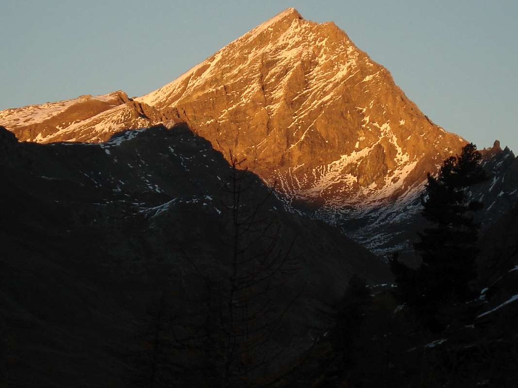 |
1) - Nobel prize for the Peace, since from now in before him he cannot quarrel among the three Communes anymore, in fact Cogne, Fénis and Champorcher will have each her "proper" POINTE TERSIVA;
2) - Nobel prize for the Geology and Tectonics, because, perhaps, first living human beings to have strengthened a new WORLD OROGENY,
3) - special recognition from the NATIONAL GEOGRAPHIC for the exceptionality of the event, immediately to spread in DVD in the whole TERRESTRIAL GLOBE. In this way the POINTE TERSIVA has Immortalized Anthony & Osw!!!...
ANEDDOTI VARI - 4): UNA NUOVA OROGENESI ! INCREDIBILE E' NATA UNA NUOVA TERSIVA GIUST'AFFIANCO ALLA PRECEDENTE !! ANZI NE SONO NATE ALTRE DUE !!! Abbiamo effettuato una scoperta eccezionale: in Val d’Aosta a cavallo tra i comuni di Cogne, Fénis e Champorcher si é verificata una nuova ed imprevista OROGENESI! Non ci crederete e sicuramente penserete che siamo diventati matti? E no signori: "Carta cantat". Basta infatti comperare la Carta "Les Sentiers de Champorcher" dell'Agosto 2001, 3° Edizione aggiornata e corretta - scala 1:25.000, Cartografia del Comune di Champorcher con realizzazione cartografica e progetto editoriale dell'Hapax di Aosta per accorgersi di questa scoperta eccezionale. Accanto alla "vecchia" Tersiva (qui di 3.512 metri, anziché 3.515), collocata a circa 50°53 ad Ovest e circa 3°80 verso Settentrione, una nuova OROGENESI ha partorito subito a Nord-nordovest e poco oltre il Colle della Tersiva (qui segnalato con = in rosso e con la quota di 3.309 metri ma senza definizione toponomastica) una seconda Tersiva eppiù importante, perché mentre quella tradizionale riportava i caratteri in corsivo questa "new" é riportata addirittura in neretto, ma senza quota. Ma (udite, udite!) sempre sulla stessa direttiva e sulla cresta divisoria spartiacque tra le Valli di Cogne e di Fénis, leggermente più verso N-NO una terza Tersiva appare segnalata con un bel colore blù carta da zucchero o blu nave, anch'essa senza quota. Probabilmente questa improvvisa e doppia OROGENESI ha talmente sorpreso i cartografi, che non hanno fatto in tempo ad effettuare le relative misurazioni. Così abbiamo scoperto che l'antica Costa del Tessonet (varie quote di 3.327 m, 3305 m, 3.280 m, 3.273 m, 3.213 m e 3.188 m) in direzione prima N-NO e poi N-O verso la Pointe du Tessonet (3.266 m) si é improvvisamente e senza alcun preavviso rialzata formando due altre Pointe Tersiva, così brillanti & scintillanti al punto che nessuno riesce a vederle. Daltronde non é la Tersiva la MONTAGNA di LUCE? Per questa incredibile scoperta che Antonio ed io abbiamo celato al Mondo per oltre undici anni.
RITENIAMO GIUSTO
1) - Premio Nobel per la Pace, poiché da ora in avanti non si potrà più litigare tra i tre Comuni, infatti Cogne, Fénis e Champorcher avranno ognuno la "propria" POINTE TERSIVA;
2) - Premio Nobel per la Geologia e Tettonica, perché, forse, primi esseri umani viventi ad aver assodato una nuova OROGENESI PLANETARIA,
3) - Speciale riconoscimento da parte del NATIONAL GEOGRAPHIC per l'eccezionalità dell'evento, da diffondere subito in DVD in tutto il GLOBO TERRESTRE. In questo modo la POINTE TERSIVA ha IMMORTALATO Antonio & Osw !!!...
Gear
Mountaineering equipment, including rope, ice axe, and crampons.When to Climb
|
CLIMBING: during the summer months, taking into account the condition of the snow.
SKI MOUNTAINEERING: April - June The route from Gimillan is recommended for ski mountaineering, paying attention in particular to the part of path between the rocky rampart above the Alpe Pila and the cross before the Alpi di Grauson Vecchie since avalanches can fall from both slopes into the narrow valley, in the case of heavy snow-falls and sudden changes of temperature. |
 |
 |
 |
 |
 |
Mountain conditions
PAY ATTENTION!Because of the last scorching summer seasons, Tessonet Glacier must be crossed roped together and very cautiously, since many crevasses have put in an appearance.
It is highly recommended to contact the Società delle Guide di Cogne for further information
It is highly recommended to contact the Società delle Guide di Cogne for further information
Huts
- Rifugio Sogno di Berdzé (2.526m)
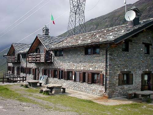 |
Bus lines
SAVDA bus lines connect Aosta to Cogne. In addition, both in summer and in winter, SAVDA shuttle bus connect Cogne with the villages (Gimillan and Lillaz, in our case).Red tape
No restriction at all: Punta Tersiva is very near but outside the borders of the Gran Paradiso National Park and Monte Avic Natural Park.
Campings
In all the Aosta Valley the camping is allowed only above 2.500 meters.Meteo
- Meteo: you can find all the needed informations at the official site of the Valle d'Aosta Region:
- Valle d'Aosta Meteo
Webcam
- WEBCAM on Aosta Valley:
- Webcam
Books and Map
BOOKS:
|
 |
 |
 |
 |
 |
- Kompass "Gran Paradiso Valle d'Aosta" Sentieri e Rifugi-Carta Turistica 1:50.000.
- I.G.C. Istituto Geografico Centrale "Gran Paradiso-la Grivola" Carta Turistica 1:25.000.
- I.G.C. Istituto Geografico Centrale "Il Parco Nazionale del Gran Paradiso" Carta 1:50.000.
- Hapax Luglio 2000 "Les Sentiers" Comunità Montana Monte Emilius 1:25.000.
- L'Escursionista "Valle di Cogne Carta dei Sentieri" (n° 10) 1:25.000.
- L'Escursionista "Tour de la Vallée de Cogne Grand Paradis" Carta dei sentieri 1:25.000.
- Hapax "Les Sentiers de Champorcher", Agosto 2001 1:25.000.
- Enrico Editore Ivrea-Aosta "Gruppo del Gran Paradiso" 1:50.000.
Important Information
- REGIONE AUTONOMA VALLE D'AOSTA the official site.
- FONDAZIONE MONTAGNA SICURA Villa Cameron, località Villard de la Palud n° 1 Courmayeur (AO) Tel: 39 0165 897602 - Fax: 39 0165 897647.
- SOCIETA' GUIDE ALPINE DI COGNE Tel. 347/9473526 – 328/1373728.
- A.I.NE.VA. (Associazione Interregionale Neve e Valanghe).
- A.IA.T. Cogne Gran Paradis via Bourgeois n° 34 Tel. 0165-74040. E-mail: aiat@cogne.org
- Ezio Sport articoli sportivi - via Bourgeois n° 64 Tel. 0165-74204.
Useful numbers
- Soccorso Alpino Cogne (SAR) Tel. 3482685406.
- Protezione Civile Valdostana località Aeroporto n° 7/A Saint Christophe (Ao) Tel. 0165-238222.
- Bollettino Meteo (weather info) Tel. 0165-44113.
- Unità Operativa di Soccorso Sanitario Tel. 118.