
-
 28703 Hits
-
 92.32% Score
-
 38 Votes
|
|
Area/Range |
|---|---|
|
|
46.68000°N / 12.10000°E |
|
|
10322 ft / 3146 m |
|
|
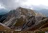
Overview
 Overview over the Prags Dolomites Overview over the Prags Dolomites |
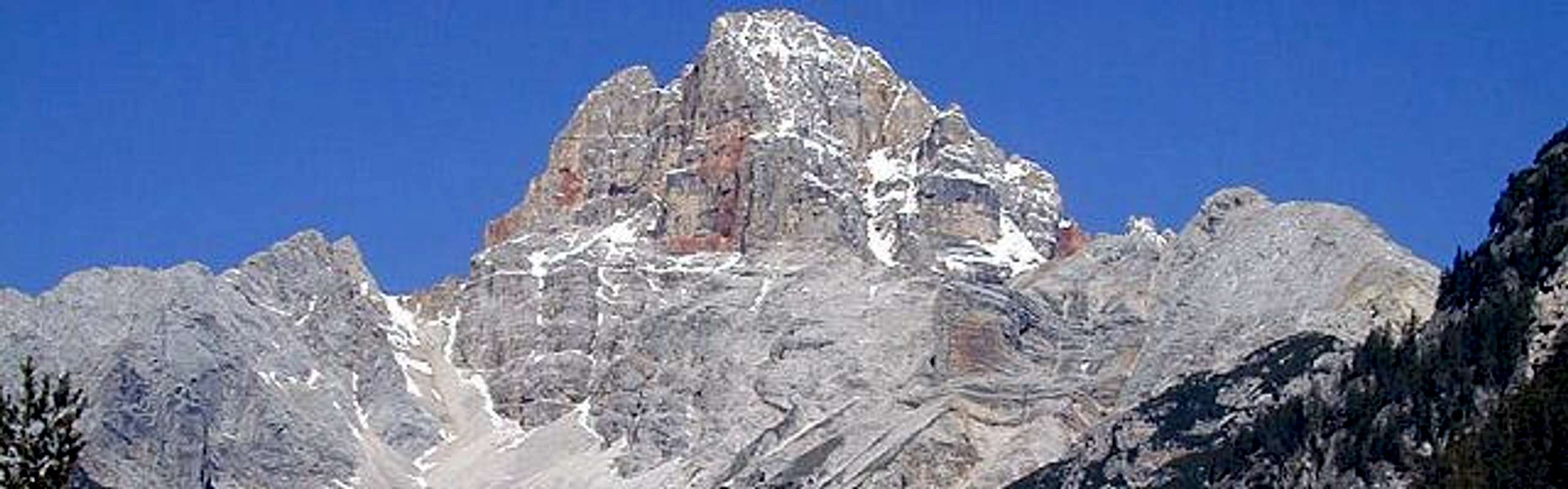
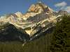
Compared to the neighbouring Sexten and Cortina d’Ampezzo Dolomites the Prags Dolomites / Dolomiti di Braies are probably the least known group of all. This isolated area can be reached by car in only two places, Pragser Wildsee / Lago di Braies and Plätzwiese / Prato Piazza, and these spots can get crowded on fine summer weekends. With the exception of its highest summit Hohe Gaisl / Croda Rossa (3146m, sometimes also counted as belonging to the Ampezzo Dolomites) it lacks summits topping the 3000m line.Moreover Hohe Gaisl is formed by rock so fragile that it is rated as one of the most difficult Dolomite mountains to climb.
Geologically the Prags Dolomites are among the most complex Dolomite groups. The solitary mountains in the east of the group are formed by dolomite rock whereas the northern main ridge is built of limestone like that found in the Dachstein area. The southern parts next to the Fanes Group are also built of limestone but here you find karst formations otherwise typical for the Julian or Kamnik Alps.
The group, together with Peitlerkofel on the other (western) side of Gadertal / Val Badia, is the northernmost outpost of the Dolomites. It forms an irregular quadrangle with its northern side larger than its southern one. The following valleys form its boundaries:
- North: Pustertal / Val Pusteria between Bruneck / Brunico and Toblach / Dobbiaco
- West: Gadertal / Val Badia in the north, then Rautal / Val di Tamores and Vallon Suro running NW to SE
- South: SS51, the road between Passo Tre Croci and Schluderbach / Carbonin
- East: Höhlensteintal / Valle di Landro
A division of the Prags Dolomites into subgroups is rather difficult because there are only a few clearly defined ridgelines. Many of the mountains are solitary summit blocks so that for the sake of organizing them into a subgroup I rather use the valleys and passes. Please feel free to comment on this subdivision – it can be changed
- Olanger Köpfe
- Monte Sella di Sennes – Seekofel Group
- Rosskofel / Campo del Cavallo Group
- The Eastern Summits
- Hohe Gaisl / Croda Rossa Group
Each of these groups will be described in a section below. Where a SP-page exists only the single summits are listed, elsewhere a short note on the characteristics will be given.

Schematic map of the Prags Dolomites with the five subgroups. See below for their description.
1 – Olanger Köpfe
Located between Pustertal / Val Pusteria in the north and Fojedöratal / Val Fossdura and Grünwaldtal / Val di Forestal in the south this subgroup includes summits which show easy ascent routes from the south but steep faces to the north. It contains the only ferrata of the whole group, the northeast ridge of Hochalpenkopf / Cima dei Colli Alti. The summits are listed west to east |
Though in principle this summit does not belong to the group, it is so close to it that it offers the best views. It is a skiing summit with lots of lifts and cablecars. No beauty in itself but a good viewpoint summit (see webcams):
 |
 |
 |
 |
 |
 |
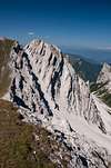
2 – Monte Sella di Sennes – Seekofel Group
This is the largest and most interesting of the subgroups. It is formed by two ridges which are separated by Krippestal and Krippesalp / Val and Alpe de Ciastin. To the north it is bounded by and Fojedöratal / Val Fossdura and Grünwaldtal / Val di Forestal, in the south by the large Rautal / Valle di Tamores. It includes the large Sennes Alpe, a karst high plateau which in some way resembles the two Fanes Alps: Kleinfanes and Großfanes. Monte Sella di Sennes and Seekofel / Croda del Lago are rather popular hiking summits. Though the trails are not easy, both can be reached without climbing experience. The summits of both ridges are listed from west to eastNorthern Ridge
- Paraccia West (2444m)
- Paraccia East (2452m)
- Krippeskofel / Monte di Groppes (2485m)
- Seitenbach Spitzen / Punte di Riodalato (2107m)
![Prags Dolomites photo_id=91600]()
![Prags Dolomites photo_id=91599]()
- Senneser Kar Spitze / Punta Quaira di Sennes (Cima Cadin di Sènnes) (2659m)
- Kleiner Seekofel / Piccola Croda del Becco (2762m)
- Seekofel / Croda del Becco (2810m)
See the SP Seekofel page for more information. Many, many climbing routes on the south face, ranged III through V+.
![Seekofel photo_id=19989]()
![Seekofel photo_id=19990]()
![Seekofel photo_id=26607]()
![Seekofel photo_id=19991]()
![Seekofel photo_id=26563]()
![Seekofel photo_id=91617]()
- Ofenmauer / Monte Muro (2458m)


Southern Ridge
- Monte Sadaic (2060m)
- Muntejela di Ciastlins (2673m)
- Monte Sella di Sennes (2787m)
- Tamersfels / Croda di Tamers (2141m)
3 – Rosskofel / Campo del Cavallo Group
The Group is located between Pragser Wildsee / Lago di Braies and the Stollabach Valley, leading to Plätzwiese (Prato Piazza). It is an assortment of summits without distinguishable ridgeline which nevertheless (or maybe just because of this) has some of the finest hiking trails of the area. There are quite a number of high passes which almost reach the altitude of the summits themselves. Peaks listed north to south (approximately).- Grosser Apostel / Grande Apostolo (1995m)
- Herrenstein / Sasso del Signore (2447m)
![]()
- Herrensteinturm / Torre del Signore (2395m)
- Daumkofel / Monte Daumo (2259m)
![]()
- Kleiner Apostel / Piccolo Apostolo (1711m)
- Kleiner Rosskofel / Campo del Cavallo Piccolo (2594m)
- Gamsalpenkopf / Sella dei Camosci (2543m)
![]()
- Grosser Rosskofel / Campo Cavallo (2559m)
![]()
- Schwalbenkofel / Monte delle Rondini (2481m)
- Grosser Jaufen / Giavo Grande (2477m)
![]()
- Kleiner Jaufen / Piccolo Giovo (2372m)


4 – The Eastern Summits
Still more solitary than the summits of the Rosskofel Group the mountains on the eastern side of Plätzwiese really stand alone. It ranges from Stollatal in the west to Höhlensteintal / Valle di Landro in the east and touches Pustertal / Val Pusteria in the north ending at Schluderbach / Carbonin in the south. Judging from the area the group is very large but it contains only few summits. Much of the area is taken by two high plateaus: Helltaler Schlechten / Crepe di Val Chiara to the north and Strudelalpe / Alpe Specie to the south. On the latter you can find quite a number of WW I fortifications – the area was one of the most contested sections of the front between Austria and Italy which ran directly through the center of the Dolomites. Höhlensteintal / Val di Landro was (and still is) an important north – south route and the forts on both side of the Valley still tell the story. If interested, visit the WW I museum on Monte Piana to the east of Höhlensteintal (see Sexten Dolomites page). Summits listed north to south- Sarlkofel / Monte Serla (2380m)
![]()
- Lungkofel / Monte Lungo (2282)
![]()
- Messnerköpfe / Punta del Monego (2199m)
- Kasamutz / Monte Casamuzza (2333m)
- Sarlkopf / Punta di Serla (2314m)
- Kirchler Schroppen / Rocce della Chiesa (2280m)
- Dürrenstein / Picco di Vallandro (2839m)
![]()
- Strudelköpfe / Monti Specie (2308m)
![]()
- Knollkopf / Col Rotonda dei Campi (2204m)


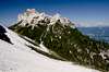
5 – Hohe Gaisl / Croda Rossa Group
This group has also been described (in part) on the Cortina Dolomites page. The border between the two Natural Parks Fannes-Sennes-Prags and Cortina d’Ampezzo runs straight over the main ridge line, which itself runs in a NW to SE direction. There are two side ridges to the west and east each. It is the highest of the subgroups with the main summit, Hohe Gaisl / Croda Rossa at 3146m. Summits listed from NW to SE.
- Rote Wand / Remeda Rossa (2605m)
- Rauhe Gaisl / Croda Scabra (2210m)
- Gaisele / La Crodetta (2445m)
- Kleine Gaisl / Piccola Croda Rossa (2859m)
- Monte Geralbes (2448m)
- Schlechtgaisl / La Crodaccia (2531m)
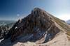
- Hohe Gaisl / Croda Rossa (3146m)
![Prags Dolomites photo_id=185211]()
![Prags Dolomites photo_id=185210]()
![Prags Dolomites photo_id=91607]()
![Prags Dolomites photo_id=92025]()
![Prags Dolomites photo_id=194232]()
- Castello di Valbones (2477m)
- Gumpalspitzen / Cime Campale (2772m)
- Punta del Pin (2682m)
- Gaislköpfe / Sassi della Croda (2127m)


Getting There
From NorthTake A22 Brenner Motorway to exit Brixen / Bressanone and turn off onto SS49 east to Bruneck / Brunico or Toblach / Dobbiaco.
From Austria (east)
Take A12 Inntalautobahn to exit Kufstein. There turn onto 178, later 161 south in direction Kitzbühel. At Mittersill 161 turns into 108 which heads through Felbertauern Tunnel. Take 108 until Lienz were you turn right (west) onto E66 which on the border crossing turns into SS49 to Toblach / Dobbiaco and Bruneck / Brunico.
From Udine
Take A23 north to exit Carnia. Turn off onto SS52 which leads through several detours to Innichen / San Candido, where you turn east on SS49 to Toblach / Dobbiaco and Bruneck / Brunico.
From Venezia
Take motorway S27 north towards its end near Belluno. Turn onto SS51 towards Cortina d’Ampezzo and on to Toblach / Dobbiaco.
Red Tape - The Natural Park Fanes – Sennes – Prags / Braies
In 1980 an area of 25680ha has been set aside for the natural Park Fanes – Sennes - Prags. You are required to treat the Natural Park with care: leave animals and plants in their place, use trails (especially when mountain biking), and take the official open roads with your car.For more information you can look at the park’s official website
When To Climb
The best time - as usual within the Dolomites - is June through September. October days can be picture perfect but the risk of snowfall is high. The wide valleys and easy ascents offer great possibilities for ski tours in winter.Hotels and Appartments
For hotels and apartments have a look at the websites of the towns and cities of the area:Mountain Huts and Refuges

The Following mountain huts and Refuges can be found in the Prags Dolomites Group:
Rifugios:
| Rifugio / Hut | Height | Open | Tel. |
| Seekofel / Biella | 2320m | mid June - mid Sept. | +39 0436 866991 |
| Pederü | 1548m | Dec – April / June – Oct. | +39 0474 501086 |
| Sennes | 2122m | all summer | +39 0474 501092 |
| Munt de Sennes | 2170m | July – Sept. | +39 0474 501023 |
| Fodara Vedla | 1975m | March – April / June – Oct. | +39 0474 501093 |
| Malga Ra Stua | 1668m | all summer | +39 0436 5753 |
| Plätzwiese / Prato Piazza a Prato Piazza | 1993m | all year | +39 0474 748650 |
| Dürrenstein / Vallandro al Passo Prato Piazza | 2028m | all year | +39 0474 972505 |
Bivouacs
| Bivouac | Height |
| Battaglione-Cadore | 2251m |
| Bivacco dall’Oglio-Helbig | 2253m |
Weather conditions
For weather conditions look at- www.meteoalpin.com. For the english text you have to scroll down the right frame.
- www.toblach.it
- www.dolomitisuperski/olang
Maps 'n' Books
The Maps and books I have used and read have all been written in German. Please feel free to post an addition to this section if you know worthwhile publications in other languages.Books:
Climbing
Sextener Dolomiten extrem - Alpenvereinsführer
R. Goedeke
Rother Verlag
ISBN: 3 7633 1255 2
Classic Dolomite Climbs: 102 High Quality Rock-Climbs Between the Uiaa Grades III and VII (also available on CD)
Anette Kohler, Norbert Memmel
Mountaineers Books
ISBN: 0 8988 6693 6
Vie Ferrate
Klettersteige Dolomiten
H. Höfler, P. Werner
Rother Verlag
ISBN: 3 7633 3096 8
Hülslers Klettersteigführer
E.E.Hülsler
Bruckmann Verlag
ISBN: 3 7654 4161 9
Hiking and Trecking
Höhenwege in den Dolomiten
H. Dumler
Bruckmann Verlag
ISBN: 3 7654 3860 X
Dolomiten 6 - Cortina d'Ampezzo
F. Hauleitner
Rother Verlag
ISBN: 3 7633 4063 7
Dolomiten 5 - Sexten - Toblach - Prags
F. Hauleitner
Rother Verlag
ISBN: 3 7633 4199 4
Dolomiten
P. Fleischmann
Kompass Verlag
ISBN: 3 8705 1409 4
Maps
I have been using the maps by Kompass Verlag.
Bruneck - Toblach / Brunico Dobbiaco
Kompass Map WK 57
ISBN: 3 85491 064 9
Scale: 1:50000
DOLOMITI DI BRAIES / PRAGSER DOLOMITEN / MAREBBE / ENNEBERG
Plan de Corones / Kronplatz
Tabacco Map 031
Scale: 1:25000