
|
|
Mountain/Rock |
|---|---|
|
|
38.78780°N / 104.8774°W |
|
|
7231 ft / 2204 m |
|
|
Overview
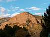
Climbing to the top of Mt. Cutler is one of the easiest and yet, most beautiful hikes in the Colorado Springs area. The trail to the top is a relatively short (1.5 miles each way) Class I hike, but packs big bang for its buck. About half way to the top Seven Falls can be seen in South Cheyenne Canyon. Upon reaching the summit you are greeted with spectacular views of the Colorado Springs skyline and the surrounding Front Range mountains. This is a small hill that hides below it’s much taller neighbors, but still towers over the prestigious Broadmoor Hotel. To the south is the Will Rogers Shrine of the Sun. If the wind is right you will hear its chimes at the top, quarter and half past hours. The summit of beautiful Mt. Rosa is to the southwest. Mays Peak is to the northwest with Mt. Almagre behind it. You can’t see the summit of Pikes Peak, but you somehow know that it is there. This mountain is a great family hike. I have done it with my wife, dog and 3 kids, with my youngest on my back in her Kielty pack. It is also a great mountain to hike with Colorado visitors, since it is only a 415 ft. elevation gain to the 7,200 ft. summit. You can take your low-land visitors to the top so that they can go back home and boast that they "climbed Cutler!" Although I have not done it at night, it is supposed to be a good after dark hike. The trail winds around the west and south slopes of the mountain. Care should be taken along the southwest bend as the trail narrows and is rocky in parts. The true summit is to the west, but a sharp spur to the east provides the best views. There are seemingly multiple trail branches that lead to the spur, but don’t worry, they all go to the same place. Beware of straying off the trail. Cutler has many steep rock faces, especially to the east and south. There have been numerous rescues of errant hikers/climbers who underestimated its steepness in places. Once again, this is an easy trail, yet very rewarding hike. Climb Mt. Cutler!
 |  |  |  |  |
Getting There
Take US Highway 24, also known as Cimarron Street or the Midland Expressway, to 21st St. Go south on 21st St., which changes into Cresta Rd. Follow Cresta to Cheyenne Blvd. and take a right. When you come to a fork in the road, take the right fork, which is North Cheyenne Canyon Road. The left fork goes to Seven Falls and the Starsmore Discovery Center is between the two. Follow the road for 1.5 miles where you will see the trailhead and limited off-road parking. If the lot is full, you may have to back track to the Mid-Columbine trailhead, then carefully walk back up the road. The Mt. Cutler parking lot can fill up quickly on weekends.
Red Tape
Not permits or fees are required. Dogs should be leashed. The nearest toilets are at the Starsmore Discovery Center.
When To Climb
This is my first year (2004) in Colorado Springs, so I am not sure what the conditions are like in the winter, but the mountain should be climbable throughout most of the year. Stay tuned for updates!
Addendum (3/05): Climb this mountain at any time, weather provided. I hiked it in a white out in December, then stripped down to a t-shirt in January and sweating. Obviously, avoid afternoon thunderstorms in the summer, but otherwise it is an easy hike to escape from in bad weather.
Camping
No camping is allowed on the mountain. Cars parked at the trailhead overnight risk vandalism.
Mountain Conditions
Check Colorado Springs weather at: http://www.weatherfirstnow.com/weather/weathernet.asp
and Mt. Cutler will be very similar. You can check out the Broadmoor Hotel web-cam at:
http://www.dickgilbert.com/colosprngs-broadmoor.htm
Mt. Cutler is right behind it.
External Links
- Colorado Springs Weather
Weather for Colorado Springs will be what you find on Mt. Cutler.
- Web-cam link for the Broadmoor Hotel
The Broadmoor Hotel sits just below and to the east of Mt. Cutler.