
|
|
Mountain/Rock |
|---|---|
|
|
38.73370°N / 106.4161°W |
|
|
13538 ft / 4126 m |
|
|
Emma Burr Mountain Overview
 Emma Burr Mountain
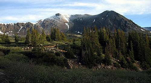
Emma Burr Mountain lies ten miles west of Mount Princeton in the heart of the southern Sawatch Range. This beautiful peak is a dominating presence on the Continental Divide; it's the tallest ranked peak between UN 13,712 near Emerald Peak and Carson Peak down in the San Juans near Lake City – over 160 miles of the Divide! Emma Burr is a 'Tri,' one of Colorado's 300 tallest peaks; it ranks in at number 229 in the state. The peak's south, east, and north ridges provide class 2 routes to the summit, and Emma Burr may hold some mountaineering challenges because there are several couloirs on her north ridge and north face. I recommend the east and north ridges as the best hiking routes to the summit because of the more scenic surroundings and the better views of Emma Burr's north face and rugged north ridge.
Emma Burr Mountain's naming origins are not well documented. Every effort I've made to uncover the history behind it has failed. A query at the USGS's Geographic Names Information System yields no information. There's no entry in the book 1001 Colorado Place Names, and the recently published Colorado Summit Hikes for Everyone states flatly "No one seems to know how this mountain got its name." Whoever Emma Burr was, for now she remains a mystery, but she was somehow important enough to be one of the dozen or so women memorialized with a Colorado mountain's name.
Mount Kreutzer (13,095') Overview
 Mount Kreutzer
Mount Kreutzer lies on the Continental Divide 1.5 miles north of Emma Burr Mountain. Colorado's 572nd tallest peak is the second of four summits reached while following Emma Burr's Grand Slam route. The peak might feel like a bit of a let-down after hiking on Emma Burr's beautiful north ridge. Perhaps the most interesting aspect about this minor peak is the white rock that covers its summit. Kreutzer features very straightforward routes from either the north or the south.
If you're not climbing Kreutzer as part of the Grand Slam route, the best access is via Mineral Basin. From high in the basin, climb grassy slopes to reach the Continental Divide, and hike south on easy terrain to Kreutzer's summit.
Chalk Rock Mountain (UN 13,055) Overview
 Chalk Rock Mountain
Gerry Roach coined the name Chalk Rock Mountain for this unnamed Continental Divide peak, which lies 1.5 miles north of Mount Kreutzer. Relatively undistinguished in most aspects, Colorado's 605th tallest peak features a fun, third-class routefinding challenge on its rugged east ridge. One of the ridge's coolest features is a lengthy ramp on its south side that helps you avoid the crest's most difficult section. Staying on the east ridge's crest the entire way is a challenge of unknown difficulty that awaits those bolder than me.
If you're not climbing Chalk Rock as part of the Grand Slam route, the best access is via Mineral Basin. From high in the basin, climb grassy slopes to reach the Continental Divide, and hike north on easy terrain to Chalk Rock's summit.
Jones Mountain South (13,218') Overview
 Jones Mountain South
Jones Mountain's southern and tallest summit, is Colorado's 469th tallest peak. This peak lies a mile west of Chalk Rock Mountain. As an aside, Jones' north summit, which will not be covered here, has an elevation of 12,995'. Given that most of Colorado's fourteeners gained 5-7 feet of elevation due to the revised geoid from the National Geodetic Survey, it is likely that Jones Mountain North is a new entrant to the list of Colorado's thirteeners.
Jones Mountain South offers little challenge to those who wish to reach its summit. Aside from a short climb up a class 2 gully to attain Jones' accommodating west ridge, it is an easy walk-up. Jones' infrequent visitors get a new perspective on Chalk Rock Mountain and a look down to Ptarmigan Lakes with Mount Yale towering above. This rounded peak saw some mining activity on its southwest slopes at some point in the past.
If Jones Mountain is your only goal for the day, please refer to the last paragraph of the Grand Slam route, and follow those directions in reverse.
Getting There
The two most common approaches for Emma Burr Mountain are made from the Arkansas River Valley east of the Sawatch Range.South Cottonwood Creek access: To reach Emma Burr's east or north ridges, take the Cottonwood Pass road, which starts in the center of Buena Vista at a junction with US-24, west for approximately 6.8 miles and turn left at the signed junction with Forest Service Road 344. The sign should tell you that a left turn leads to Cottonwood Lake. Drive approximately 9.5 miles to this road's junction with FS-344A. Past Cottonwood Lake, the road gets rougher and you may want a high-clearance vehicle. 4-wheel drive is not necessary, however, and with careful driving, I believe you could take a passenger car rather far up the road.
If you're hiking Emma Burr's Grand Slam route, you'll want to leave your vehicle at the 344/344A junction. If you're hiking up Mount Kreutzer and Emma Burr's north ridge, you can turn right and drive up FS-344A. If you're hiking Emma Burr's east ridge, you can continue up FS-344. Remember, though, you'll probably enjoy the hike more than the drive. Why not just leave your car at the 344/344A junction and enjoy your time in the wilderness?
Tincup Pass access: To reach Emma Burr's south ridge route you use the same approach road as for Mount Antero's standard route, you just drive west a lot further. Take US-285 south for 5.5 miles from the US-285/US-24 junction in Johnson Village to the small town of Nathrop. Turn right on Chaffee County Road 162 and drive approximately 22 miles to the summit of Tincup Pass. The road from St. Elmo to Tincup Pass requires a high-clearance, four-wheel drive vehicle. The crux of this road is a shelf section near the pass that can hold snow into July, according to Charles Wells in his book Guide to Colorado Backroads and 4-Wheel Drive Trails. The hike to Emma Burr's summit is 5 miles round-trip with 2460' of elevation gain, and you have to climb up and over the ranked thirteener UN 13,345 going both ways.
Red Tape
Emma Burr Mountain is located on the border of San Isabel National Forest and Gunnison National Forest. Most approaches will be entirely on San Isabel forest land. Contacting the managing agencies (see 'Mountain Conditions') is the surest way to get up-to-date information on any restrictions. There are no restrictions on vehicular travel in this portion of our public lands because this area is south of the Collegiate Peaks Wilderness.Leave No Trace suggests you observe these principles when traveling and camping in all public lands:
1. Plan Ahead and Prepare
2. Travel and Camp on Durable Surfaces
3. Dispose of Waste Properly
4. Leave What You Find
5. Minimize Campfire Impacts
6. Respect Wildlife
7. Be Considerate of Other Visitors
When To Climb
The easiest time to climb Emma Burr Mountain is May-October, but this varies year-to-year with the snowpack. In spring or winter, the approach road up South Cottonwood Creek is buried under deep snow. Often the closest parking you can hope for is at Cottonwood Lake. A climb of Emma Burr from here would be a round trip of 20+ miles, definitely a multi-day outing.Camping
Camping is permitted in San Isabel National Forest. Good camp spots are abundant along the South Cottonwood Creek road in Mineral Basin and near Mineral Creek.Mountain Conditions
The US Forest Service is your best bet for determining current snow conditions and gathering other such information. The Salida Ranger District (719-539-3591) of San Isabel National Forest is responsible for the Sawatch Range east of the Continental Divide, where most people will do their climbing on Emma Burr.For weather information, the National Weather Service is a good place to start:
Emma Burr Mountain experimental point forecast