

-
 33866 Hits
-
 87.66% Score
-
 25 Votes
|
|
Mountain/Rock |
|---|---|
|
|
37.08160°N / 118.4887°W |
|
|
13553 ft / 4131 m |
|
|
Overview
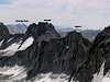
Palisade Crest is an impressive ridge comprising 12 pinnacles located in the heart of the Palisade region along the Sierra crest. The pinnacles have been unofficially named for characters in JR Tolkien's Lord of the Rings, with Gandalf Peak being the highest of the 12. Lying on the boundary between Sequoia/Kings Canyon NP and the John Muir Wilderness, it is one of the more difficult summits in the region. Because it lies some 500ft lower than the prominent 14ers found on either side, it has been historically overlooked by climbers, and even today sees much less traffic than the nearby peaks.Class 4 by its easiest route, the peak wasn't climbed until 1954 when John and Ruth Mendenhall climbed the three easternmost pinnacles (II, 5.7). The highpoint, Gandalf Peak, located on the far west end, wasn't climbed until 1967 by Don Jensen of the Palisade School of Mountaineering (via the class 4 NE Face). Don also pioneered the class 4 NW Ridge and was the first person to complete the traverse of all 12 pinnacles (III, 5.5) in 1969.
 |  |
Getting There
Take US395 to Big Pine. Drive west on the Glacier Lodge Rd to the end. Overnight parking is clearly marked, and lies furthest from the trailhead, just before the pack station. Dayhikers can drive to the end of the road and park in any of the appropriately marked spaces. Take the South Fork Trail to the turnoff to Willow Lake. There is no maintained trail past the signed turnoff, but use trails can be used to avoid much tedious cross country travel. A use trail follows close to the south side of the creek until just before the bog/marsh marked on the maps on the south side of the creek where a side stream from the south enters (this is the stream draining the north side of Palisade Crest). Cross over to the north side, hike upstream over boulders to the next stream confluence. Follow one of two drainages up to Elinore Lake. The right side has some evidence of use trail, but both routes seem to take about the same time.From the south in the vicinity of Deer Meadow, hike up Glacier Creek several thousand feet to Lake 3559m. Then climb NNE to Scimitar Pass and the Northwest Ridge up much talus and boulders. From Palisade Lakes, Lake 3559m can be reached via Cirque Pass (class 3), to the west of the lowest of the Palisade Lakes. From Bishop Pass, the easiest route to Lake 3559m is via Thunderbolt Pass and Potluck Pass. This route avoids much elevation loss to the JMT, but requires much cross-country travel over boulder and talus.
Red Tape & Mountain Conditions
Overnight permits are required and quotas for the South Fork of Big Pine Creek are in effect from May 15 to September 15. The South Fork is far less popular than the North Fork trail, so getting permits is not usually a problem.Those approaching from the south will be travelling through and camping in SeKi National Park, also requiring permits.
Everything you need to know about conditions, permits and regulations can be found on the Eastern Sierra - Logisitcal Center page.
When To Climb
May to October are the usual climbing months. Early in the year there is much snow (and considerably more gear to carry).Camping
Camping is allowed in most places of the SEKI and John Muir Wildernesses that surround Palisade Crest. For north side approaches, by far the most popular camp location is found along the shores of Elinore Lake. With shade and easy access to water, Elinore Lake is only about 1 1/2 miles from the summit.On the south side, suitable campsites can be found along the John Muir Trail in the vicinity of Palisade Lakes or lower down in Deer Creek Meadow where Glacier Creek joins Palisade Creek. Higher campsites in more barren surroundings can be found in Palisade Basin or along the shores of Lake 3559m.
Etymology
"The Palisades were named by the Brewer party of the Whitney Survey in 1864. '... along the Main crest of the Sierra, is a range of peaks, from 13,500 to 14,000 feet high, which we called "the Palisades." ... they were very grand and fantastic in shape.' (Whitney, Geology, 393.)"- Peter Browning, Place Names of the Sierra Nevada