Pfannspitze / Cima Vanscuro

Pfannspitze / Cima Vanscuro

Page Type Page Type: Mountain/Rock
Location Lat/Lon: 46.67950°N / 12.50240°E
Additional Information Elevation: 8786 ft / 2678 m
Sign the Climber's Log

Overview


Geographical Classification : Eastern Alps > Carnic Alps > Carnic Alps Main Ridge (West) > Pfannspitze / Cima Vanscuro

Pfannspitze photo_id=121263

Pfannspitze / Cima Vanscuro is the first of the main summits of the Carnic Alps Main Ridge as you come from the western starting point of the ridge. It also is the last of the black summits, consisting of volcanic rock. As you head out towards the east from Pfannspitze you will encounter the limestone cliffs of Grosse Kinigat, Kleine Kinigat and Porze. Moreover, to the north you find Rosskofel, another Limestone mountain and it is the contrast between Pfannspitze and Rosskofel, black volcanic and white limestone rock which defines the whole area. Just see the picture above to see what I mean.

Pfannspitze is a very popular destination, especially when hiked to from the northern (Austrian) side. There is a refuge at the base of the summit block, Obstanser See Hütte, which also is the westernmost relay point in the Karnischer Höhenweg Trekking Trail, which follows the complete Carnic Alps Main Ridge for about 140km. The round trip from Kartitsch in the Tyrol Gailtal Valley, which heads out Winkler Tal Valley to Pfannspitze, follows the main ridge towards Kleine and Grosse Kinigat and heads back again to Kartitsch through Erschbaumer Tal Valley is one of the most popular, but also most strenuous round trips in the region. If you climb one of the two Kinigats together with Pfannspitze the round trip amounts to 1600m of elevation gain and 23km length. A long day....

The ascent to Pfannspitze is a rather easy one. There are two normal routes, one heading from Obstanser See in the north towards the summit, the other along the ridge coming from the Kinigats. A more adventurous tour heads for the saddle between Pfannspitze and Rosskopf (called Rosskopftörl, 2493) from where you take the Pfannspitze northern ridge/flank/slope to the summit.

Like all the summits of the western part of the Carnic Alps Main Ridge Pfannspitze is a very popular ski tour destination in winter. Many people take one of the lifts from Sexten / Sesto to Helm (the westernmost summit) and follow the ridge for several km. From Pfannspitze you can head down to Kreuzbergpass / Passo S. Croce from where several broad trails return to Sexten again.

And the main reason for visiting Pfannspitze? The views, of course! Besides the obvious backside view towards Kline and Grosse Kinigat along the Carnic Alps Main Ridge you can enjoy the view of the long eastern chain of the Sexten Dolomites. The pictures certainly don't tell you that this is almost a 180° view in which you can see all the towers, spires and summits of the range. To the north you can see towards Hohe Tauern with the Rieserferner Group in the north-west and Grossglockner directly to the north. And north-eastwards there is the complex group of the Lienz Dolomites....
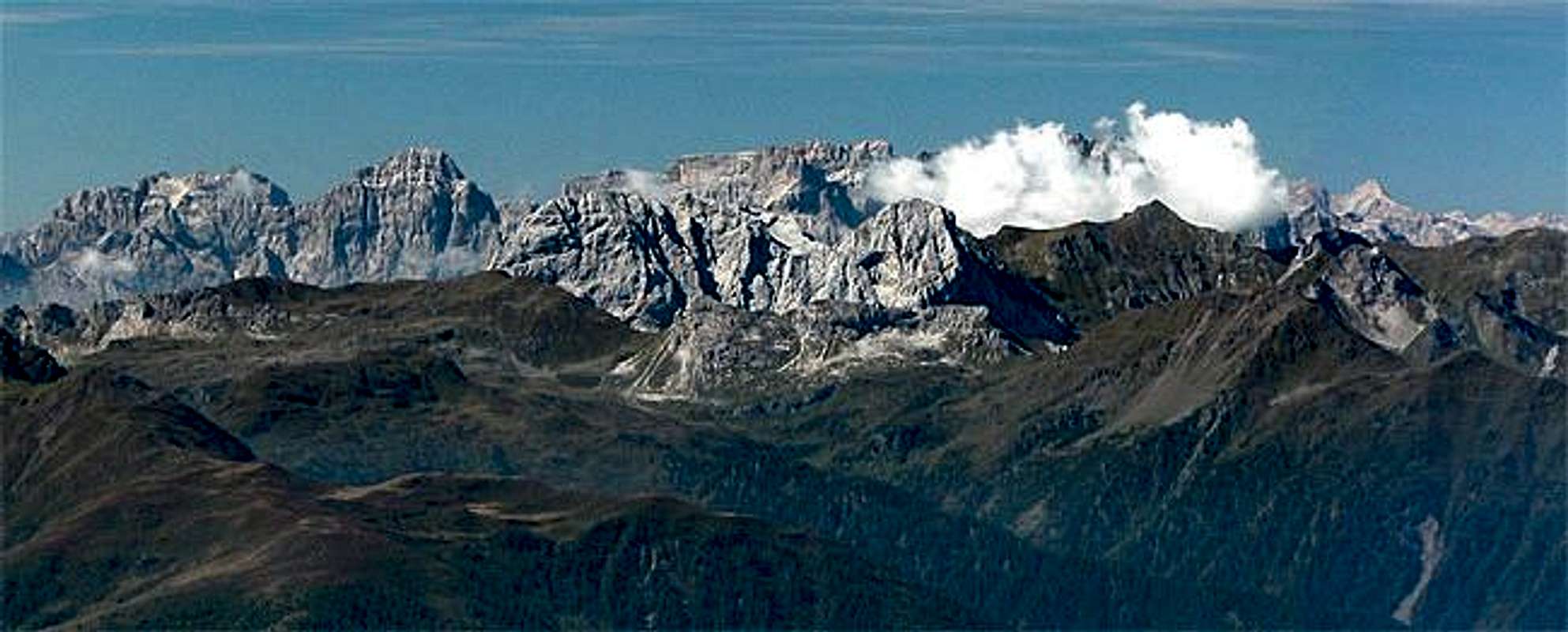
Summit views


Pfannspitze photo_id=121267Pfannspitze photo_id=121268


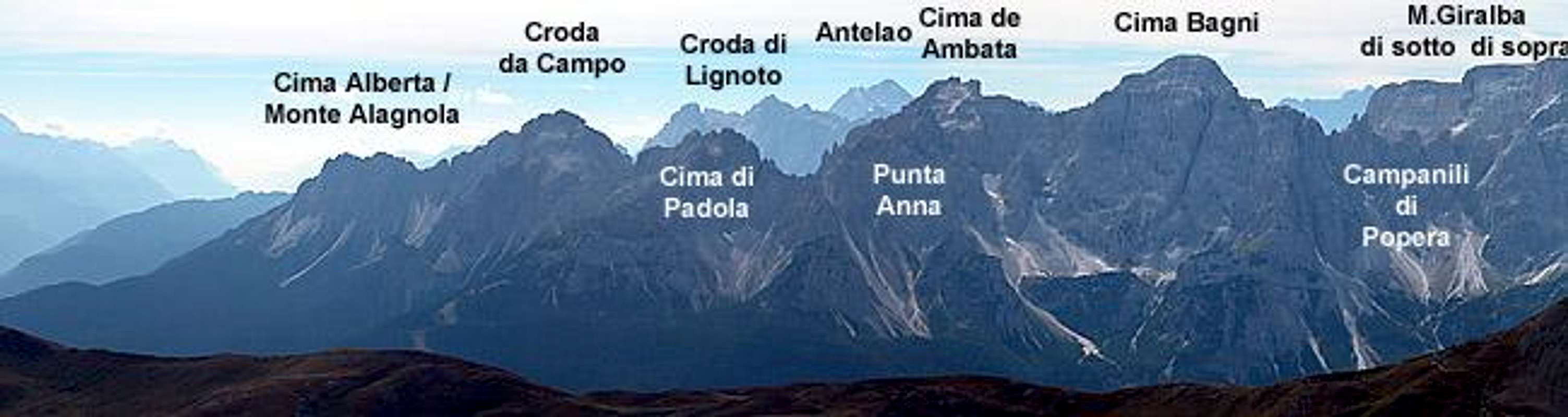
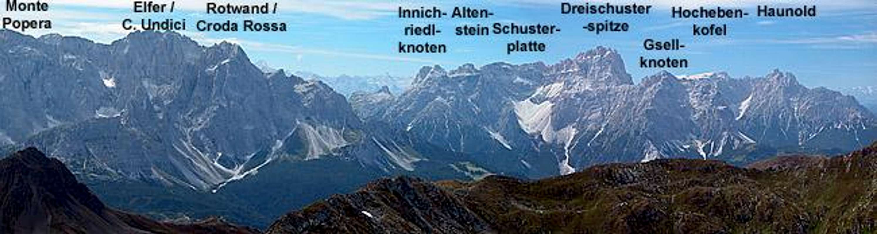
Sexten Dolomites panorama taken from the summit of Pfannspitze. Both pictures combine into a 180°view

As said above, the main attraction about Pfannspitze are the views. It is hard to tell which direction is the best. I decided on the Sexten Dolomites here. Still we had far from perfect weather so that the pictures are a little hazy :-(

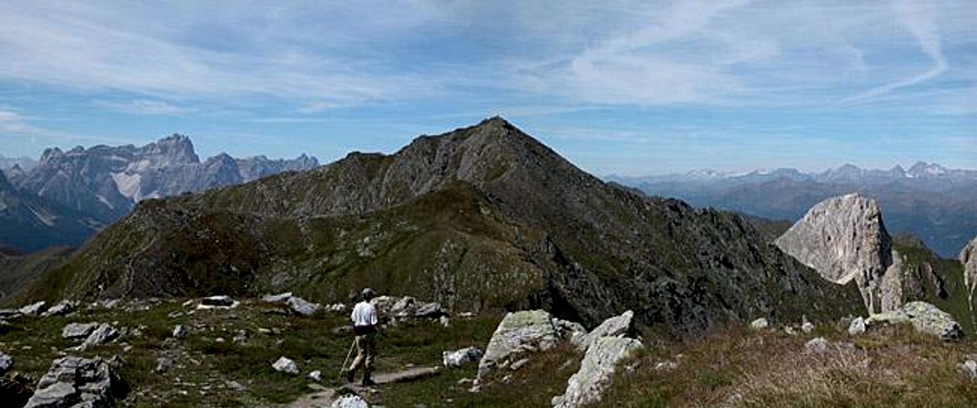
Pfannspitze seen from other mountains


Pfannspitze photo_id=121273

The combination of the Königswand, Grosse Kinigat, Kleine Kinigat Trinity together with Pfannspitze makes for a pitturesque and easily recognizable view from other summits. Here's a selection.
Pfannspitze photo_id=115361Pfannspitze photo_id=115353Pfannspitze photo_id=119119Pfannspitze photo_id=119105Pfannspitze photo_id=119104Pfannspitze photo_id=121275Pfannspitze photo_id=121274

Getting There


Western Main RidgeWest Central Main RidgeCrode dei LongerinPeralba - Chiadenis - AvanzaEast Central Main RidgeBiegengebirgeKellerwand - Hohe WarteMooskofel GroupRinaldo Group
Interactive map of the western part of the Carnic Alps Main Ridge. The numbers refer to the respective subgroups as given on the Carnic Alps Main Ridge (West) Page. Click on them to go to the subgroup description. Pfannspitze is located to the east of subgroup 1.

The best starting point for an ascent of Pfannspitze is the village of Kartitsch in the Tyrol Gailtal Valley. The village is located on B111 the main road running through the Tyrol Gailtal and Lesachtal Valleys. The trailhead is located a little southwest of the village near the sports field. Kartitsch can be reached as follows:

From the West (Brenner Motorway A22)
Leave the Brenner Motorway near Brixen / Bressanone and follow SS49 to the east through Pustertal / Val Pusteria. To the east of Innichen / San Candido you cross the Austrian-Italian border and follow the road (now B100) to Tassenbach. Turn right (south-east) here onto B111, which you follow in direction Kartitsch. In Kartitsch at the grocery store turn right into the village and follow the signs to the sports field.

From the North
There are two possible roads:
  • From Kitzbühel over B108 through the Felbertauern Tunnel to Lienz, then southwest to Tassenbach (B100), where you turn on to B111 east into the Tyrol Gailtal.
  • From Salzburg along motorway A10 to Spittal. Turn west on B100 to Oberdrauburg, there south to Kötschach-Mauthen were you turn east on B111. You need to go through the whole Lesachtal Valley to reach Kartitsch.

From the South (Udine)
Take Motorway A23 to the exit Camia Tolmezzo. Follow SS52 north to Tolmezzo where you turn onto SS52 bis. This leads to Plöckenpass, where it crosses the Austrian-Italian border. In Austria the road turns into B100 and at Kötschach-Mauthen you have to turn east on B111 into Lesachtal Valley. Again, go on through the whole valley to Kartitsch.

Red Tape


There's no red tape other than the obvious when hiking in a border region - take your ID and don't camp on the mountain. For camping head for Obstanser See and ask the proprietor of the hut to let you use the grounds around the lake.

When To Climb


Pfannspitze can be climbed all year round. Obviously the hiking season is between May and October but - depending on the weather of course) you can head for the mountain also in late autumn or early spring. In winter ski tours along the normal ascent or along the long Carnic Alps Main Ridge are possible

Accommodation


As said above camping on the border is discouraged. Stay at the refuges (see here) or at one of the little campgrounds in Lesachtal Valley. The latter are mostly associated with an inn or hotel. If you are looking for hotel rooms or apartments follow one of the links below

Weather Conditions


The Carnic Alps Main ridge is a weather divide in northern or southern wind conditions so it pays to keep informed about the weather on both sides of the border. Look at one of the links below or (even better) call the proprietors of the huts. You'll find all phone numbers on the Carnic Alps Main Page.

Maps 'n' Books


Maps
I have been using maps by Kompass Verlag, which are very good for the hiking trails though they don't show ALL the relevant summits of the area.
  • Lienzer Dolomiten / Lesachtal
    1:50000
    Kompass Map WK47
    Kompass Verlag
    ISBN: 3-85491-053-3
  • Tabacco Map 10: Sesto
    1:25000

As for books please look at the appropriate section of the Carnic Alps page.


Children

Children

Children refers to the set of objects that logically fall under a given object. For example, the Aconcagua mountain page is a child of the 'Aconcagua Group' and the 'Seven Summits.' The Aconcagua mountain itself has many routes, photos, and trip reports as children.