
|
|
Area/Range |
|---|---|
|
|
42.30000°N / 19.60000°E |
|
|
8839 ft / 2694 m |
|
|
Overview
Highest range of the Dinaric Alps
"The most inexplicable, the most unapproachable and the wildest mountain range on Balkan peninsula and, after Alps, in Europe. Southern Alps of Europe!"
Ami Boue, French travel writer
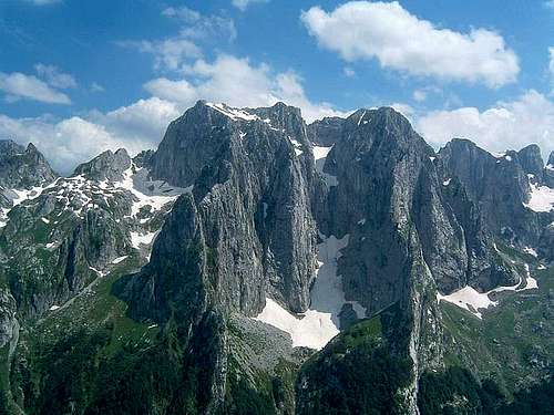
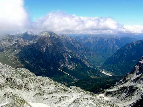
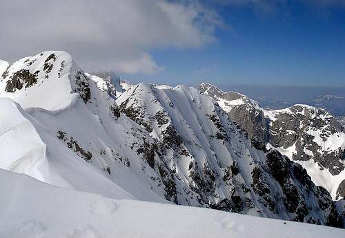
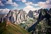
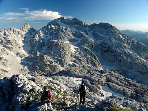
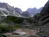
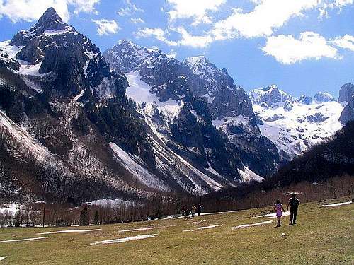 Prokletije peaks above Grbaja Valley
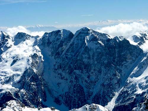
"Nowhere in the Balkan the glaciers have a left such a deep trail of their erosion as in Prokletije mountain range. After Alps, this was the most glacial mountain in Europe", said Jovan Cvijic, Serbian geographer.
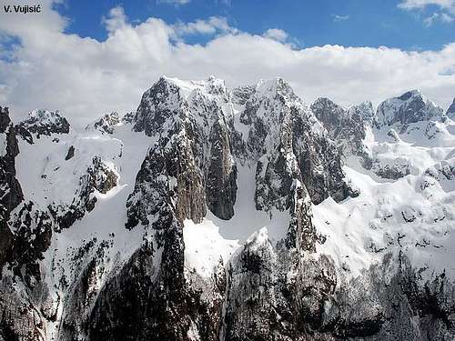
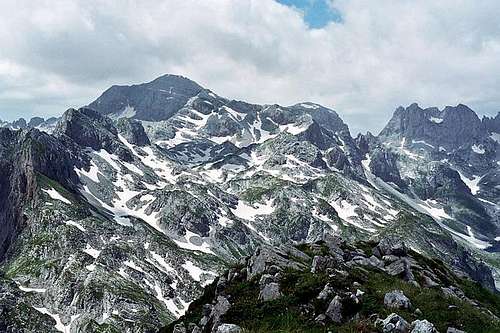
The Prokletije mountains are one of the highest and without doubt most hyperkarstic mountain ranges of the Balkan Peninsula whose white naked karstic and jagged ridges and peaks, build form limestone and dolomite show many cirques that create an imposing wild image which sends shivers and fear to visitors (as geographer Jovan Cvijic said in 1913).
Because of it's impressive and amazing beautty, Prokletije Mountain is also known as "Southern Alps of Europe".
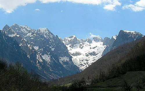
 Amazing Karanfili from Grbaja Valley
 Impressive outlook of Ocnjak peak
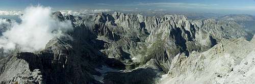
Prokletije is surely one of the last mountains in Europe that has not been discovered entirely yet, one of the most enclosed, most reserved and most romantic places in Europe.
The Alps, the Dinaric Alps and the Prokletije Ranges represent a unique mountain system made by a folding action of the African plate which is under the European one. This process is visibly evident also by the constant listing of the Adriatic coast. The Dinaric Alps, 1000 km long, follow the direction of the Adriatic Sea and at their northwest and southeast ends formed the 'aggregates' of the Alps and the Prokletije massif.
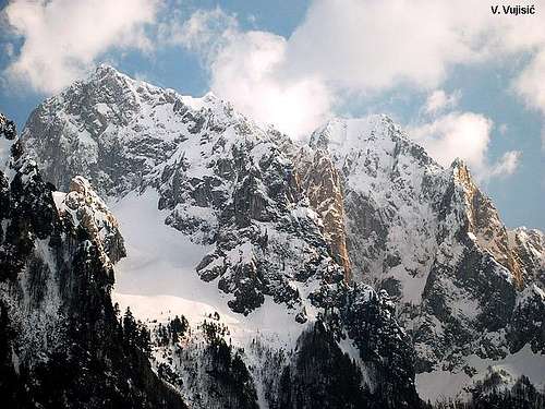
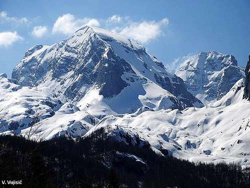
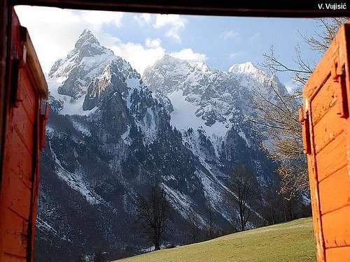
 Incredible view to Prokletije massif
 Amazing Karanfili group from Volusnica
These two groups are of latter geological origin, made by the action of tectonic forces on the edge of the plate. This theory is confirmed by the great tectonic divide which extends from Herceg Novi towards Trebinje, and farther inland. This divide was made by cracks in the Balkan land, due to the resistant force of the Prokletije mass. Along this fissure there are constant earthquakes of tectonic origin.
Like the Alps, the Prokletije Mountain range also deviates from the extension of the Dinaric Alps. The massifs and aggregates that formed are very tall. The French travel writer Ami Boue was right when he called the Prokletije - "The Southern Alps". Many geographers today consider the Prokletije as a continuation of the Dinaric Alps. The names "Prokletije" and in Albanian "Bjeshket e Nemuna" (mean "The Damned Mountains"), which describes the cruelty of these mountains and the hard life of those who live in their vicinity.
 Maja Briaset (2567 m)
 Incredible massif of PROKLETIJE range
The Prokletije range consists of 40 mountain wreaths between the Zeta plain, the Drim River, Plav - Gusinje Prokletije, and the Komovi&Bjelasica, all to the mountains of the Kucka Krajina. The Plav - Gusinje Mountains are massifs in the confluence of the rivers Komoraca, Jasenica and Djuricka Rijeka, south southeast of Plav, then the rivers Vruja and Dolja, on the south southwest of Gusinje. All of these rivers are right tributaries of the Lim River. From the left this area is bordered by somewhat lower mountains with steep slopes, which extend toward the Plav - Gusinje valley: Lipovica (1882 m), Greben (2196 m) and Visitor (2211 m), while from the north wreath is Zeletin (2126 m).
 Kolac - Kolata (2528 m)
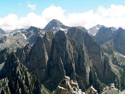
 Karanfili (2460 m, 2490 m, 2441 m)
The Montenegro - Albania border is most of the Plav - Gusinje Prokletije range and their peaks are above 2000 m. It is a hydro - geologic watershed of the Adriatic, the origins of the Drim River and its tributaries and the Black Sea River basin, as well as the Lim River and its tributaries.
The Prokletije range in Montenegro is approximately 250 square kilometres, and extends from Skadar to Bogicevica, on the border with Kosovo. Ina a wider sense, Montenegro's Prokletije mountain range is bordered by the rivers Cijevna, Lim and Ibar.
Massif of Prokletije mountain is <b<70 km long - rises gradually toward southwest and northwest from the Zetsko-Skadarska valley, ending up with the highest peaks of Bogicevica and Cakor and Rugova passes, where the highest crests - Jezerski Vrh/Maja Jezerce (2694 m) on Albanian territory, Djeravica (2656 m) on Serbian and Kolac/Maja Kolata (2534 m) on Montenegrin territory are located.
 Maja Jezerce from Karanfili summit (zoom)
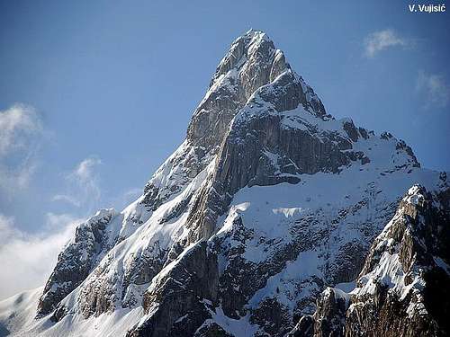
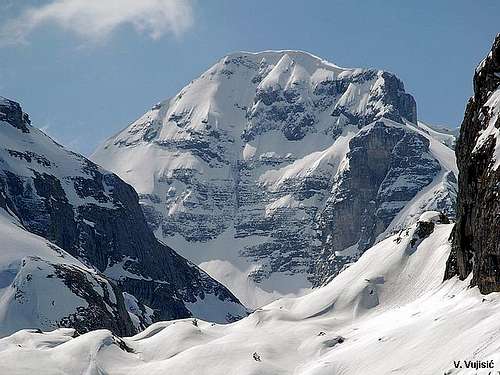
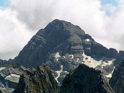
 Maja Jezerce/Jezerski Vrh (2694 m) - highest peak of Prokletije
"Prokletije" is the Montenegrin name for the mountains the other side of which is the North Albanian Alps. The smaller part of the mountain range is in Montenegro referred to as Prokletije, with highest peak Kolac (Maja Kolata, 2534 m). Also, on Serbian territory (on Kosovo, now under UN protectorate) is one part of Prokletije massif, with highest peak Djeravica (2656 m), second highest peak of whole Prokletije range, behind the highest one - Maja Jezerce (2694 m).

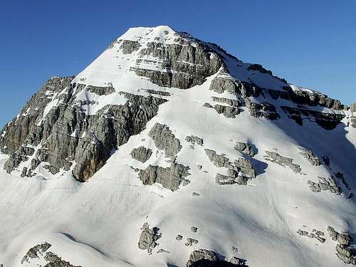
Djeravica (2656 m)
Considering the territory of the Balkan Peninsula, glacial erosion was the most significant in the Prokletije thus the most dramatic forms of the ice-age can be found there. The Prokletije range has much larger formations than the Dinaric Alps. They are formed of Paleozoic stone at the core and covered by Mesozoic and Tertiary sediment layers. The western region is mostly composed of Triassic and cretaceous white to gray limestone, and less of dolomite. This composition has also caused jagged rocks and sharp spike relief, while its east and north regions have rounded formations as a consequence of geological relief forms of typical slate and stone layers.
Glaciations of the Prokletije Mountain range:
Geographical latitude of the Prokletije, although south of the Alps, caused severe rainfalls and set the snowline at 1500 m, while the Alps are at 2800 m. Today there are no permanent glaciers in Prokletije, but the traces of their movements are visible in the troughs, waves and cirques. Long ago, the largest glaciers moved along the valleys of Vrmosa, Grncar and the Plav - Gusinje basin. The largest in the Balkans was the Plav glacier, which extended from Rikavac to Novsic near Plav. It was 35 km long with ice up to 200 m thick.
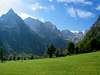
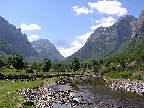 Beautiful Ropojana Valley
 Beautiful Valbona Valley
From northwest to southeast, the Prokletije Mountain range includes these peaks: Lipovica (1882 m), Trojan (2190 m), Guriku, Popadija (2057 m), Volusnica (1879 m) and Karaula (1915 m). The Maja Fort is on the Albanian side of the border. With a height of 2499 m, it is the highest peak of the Zastan range.
Maja Jezerce
The Karanfili (carnation) massif include three peaks: to the north - Severni Vrh/Maja Bals/North Peak (2460 m) and Veliki Vrh/Kremeni Vrh/Big Peak (2480 m); to the south - Juzni Vrh/Zlovrh/South Peak (2441 m), Karanfil Ljuljasevica (2240 m), with branches of Podgoja (2029 m) and Vezirova Brada (1781 m).
Mt Bjelic with its highest peak, Rosni Vrh (Maja Rosit, 2525 m) is the third highest peak in Montenegro. Maja Kolac (Maja Kolata) with the Zla Kolata (Kolata e Keq, 2534 m) and Dobra Kolata (2528 m) are the two highest peaks of Montenegro.
But, officially the highest peak of Montenegro is Bobotov Kuk (2523 m) in Durmitor massif. Reason - Durmitor is in the center of Montenegro territory and it is closer to heart of Montenegrins than Prokletije peaks on border with Albania, which are not in the center (inside) of country.
Farther in that range to the east is: Maja Bor (2149 m), Maja Scapica (2044 m); with Krs Bogicevica (2374 m) join the Kosovo mountains of Maja Rops and Bogdas (Marijas). There are many kinds of alpine rocks in the Prokletije Range. Listing the most famous: Koplje (600 m), Volusnica (250 m), Ocnjak (Canine Tooth, 180 m) and Karanfili's Norhern Peak (450 m).
 Prokletije massif from Dolja Valley
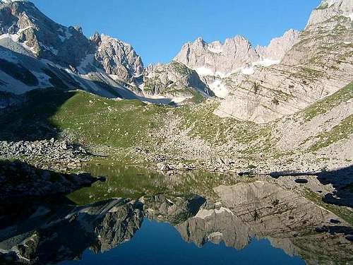
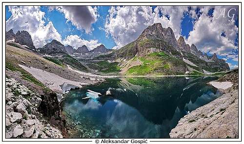 Liqeni Madhe (1792 m) lake in Buni Jezerce valley
Valleys are deep and wide while peaks are edgy and seem to be almost inaccessible. There are a plenty of smaller or bigger glacial lakes in the mountains. Their number is the second most one in Europe following the Alps! Plavsko Lake is the biggest one along the shore of which a lot of holiday homes and pensions were built.
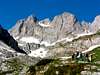
Maja Popluks (2569 m)
Prokletije has a fantastic panorama, wide, flowery and green valleys, steep mountainsides, peaks pushing skywards, idyllic meadows, purling brooks and sight for the gods. But before everything else its most important characters are wildness and being undiscovered.
It is almost impossible to find any travel report about the mountains because they do not exist. People are friendly, hospitable and the visitor is not threatened by any danger. Nevertheless, the atmosphere of the whole mountain range is extremely mysterious and wild. You can reach to passes and peaks where foreign tourists have never ever been and this gives the excitement of real discovery.
This powerful mountain range continues geomorphologically toward north with Nedzinata (2341 m), Cakor (2046 m), Mokre Planine (1932 m), Hajla (2403 m) and Mokra Gora (2154 m).
Prokletije are today hugh mountain massif - on both side of Serbian&Montenegrin/Albanian border. From west near Rikavachko lake, Prokletije goes to east, till Pech town. North border of Prokletije is Rozhaje town, on the south - Thethi and Valbona valley in Albanian part of massif.
 6 Jezerce Lakes Valley glacial lake
 Maja Rosit summit view to Maja Jezerce

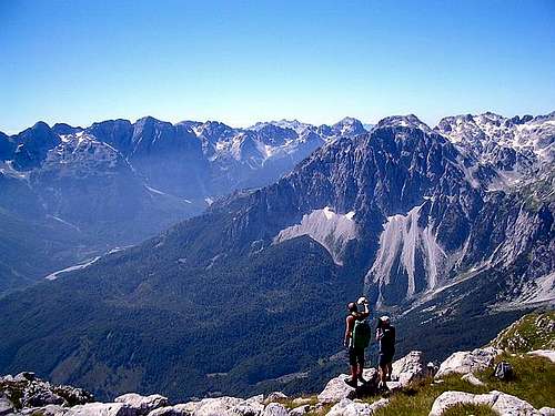
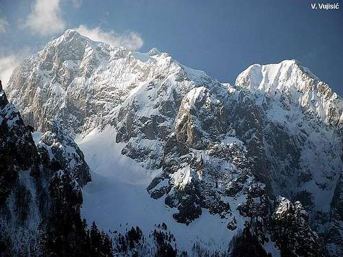
Prokletije massif
The strongest and most intensive glaciation in the Balkan has left the deepest trails of glacier erosion in the form of numerous basins in which tens of small glacier lakes have remained.
The trails of glacier activities, as a rare natural value, present extraordinery aesthetic attraction. None of these natural caprices, the cogged pointed peaks, unreachable crests, deep glaciers, steep cliffs, numerous springs, have been spoiled by human hands.
Prokletije is the hydrological knot of all the Dinaric ranges where important rivers begin. Tara and Lim River - the two main sources of the Drina are located on the Komovi Mountain. The huge Drin waterfall in Kosovo is the source of the white Drin whose tributaries include the Valbone in the Bjeshket e Namuna, how Prokletije are called in northern Albania. That means "Damnad Mountains", from it's hardness and brutality outlook.
Prokletije is still one of the least known mountain ranges of Southeast Europe.
When the Balkan wars of 1912/13 forced the defeated Ottoman empire to give way of its territories, hawkish politicians in Vienna watched carefully that a borderline was created that crossed every valley that was of use for the purpose of its main rivalry on the Balkans Serbia to get to the Adriatic sea.
The newly formed Albanian state got so its boundary in the Prokletije that blocked the Lim-Cijevna transversal, the only possible route through Porkletije. In that game questions of ethnicity played the least role, family ties were deliberately broken and traditional routes of nomads who every year traveled with their livestock in a boundary free Ottoman empire over 600 km from Prokletije to Thessaly, Srem and Banat.
 Karanfili (2490 m) summit view
 Veliki Karanfil and Juzni Karanfil from Severni Karanfil
Still today Prokletije is one of the densely inhabited mountains of the Southeast with important mountain clans like Kuci (Serbs, Montenegrins), Grude, Hoti, Kastrati, Klemente and Shkrelje (Albanians).
Wild guessing game was going on during the first two decades of the 20th century about which peak deserves the name of the highest in the Balkans. No one was sure as many peaks where clouded in myths and even fewer measured.
Serbian geographer Jovan Cvijic guessed, when he investigated Prokletije in 1913, that it was around 2800 m but claims of 3000 m were made deliberately.
The first measurements were actually done by Baron v. Nopcsa and Nowack who were geologists and spend several years in this region (Baron Nopcsa wrote a huge monography of the geology of Prokletije in 1929, he actually was also an ethnographer like Cvijic and very opposed to Serbian claims in the region).
Although Rila, Pirin, Olymp and Sar Planina-Korab are higher than Prokletije, it's here, where the most impressive high mountains of the Balkans are. The greatest glacial valleys and the largest glacial lake on the Balkan, Plav, is found here, in the Prokletije.
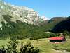
The starting points to explore Prokletije mountains from Montenegrin side are Grbaja and Ropojana valley, with two mountain cottages and two picturesque places, Plav and Gusinje, located at the foot of the mountain. Near Gusinje, there are Ali Pasa's springs where, traditionally, people from Plav gather every year.
 Impressive massif of Kolac (Kolata)
 Breathtaking scenery of Karanfili peaks
From Serbian side you can start from Decani town - route to the summit of Djeravica (2656 m), second highest peak of whole Prokletije massif, behind Jezerski Vrh/Maja Jezerce (2694 m) - the highest one. This area on south part of Serbia (Kosovo) is now under UN protectorate.
From Albania, you can go in the heart of Prokletije massif through valleys as Valbona and Thethi.
Also, many mountain lakes are specially attractive to visit. The most popular lakes are: Plavsko, Ridsko and Visitorsko. Plavsko lake (near Plav town) is the largest lake, Ridsko is one of the most beautiful mountain lakes in Montenegro, while Visitorsko lake is specially interesting because of the floating island formed on its surface. The legend says the island use to be a raft made by casttle breeders who wanted to protect their herds from wild animals. Since the raft was well fertilized, soon it was covered with the dense grass and after its decomposition, the peat stratum 80 cm wide was made.
Prokletije are authentic and very natural mountain, without any commercial influence. You will find there a taste of total peace and freedom. That's really a great privilege!
The initiative to protect Prokletije area as a national park has been taken for a long time.
Valleys as Grbaja, Ropojana (in Montengrin part of massif), Thethi and Valbona (in Albanian part of massif) are so impressive and beautiful that you will never forget them. Unforgetable beauty!
 Kolac - Kolata (2528 m) summit view
Also, many people who visited Grbaja valley with it's amazing beautty and high peaks on both sides, said that this valley is very similar with "Logarska valley" in Kamnisko-Savinjske Alps in Slovenia, one of most beautiful valleys in Slovenian Alps.
When you step on Prokletije the doors of the astonishing ecological treasury will immediately open in front of you.
If you want to get rid of the millennium rush or consumer mania and having enough adventure spirit for a close encounter with outcomes of the world creation - Prokletije mountains are what you have been dreaming of.
So, it's right time for discovering of this "Southern Alps of Europe"!
Welcome! Good luck!
 |
 |
 |
 |
 |
Getting There
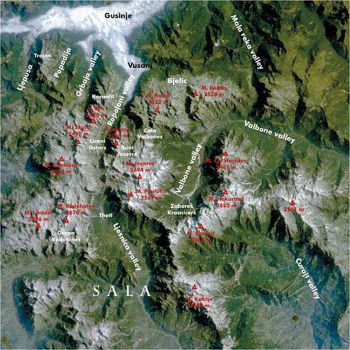 Map of Prokletije

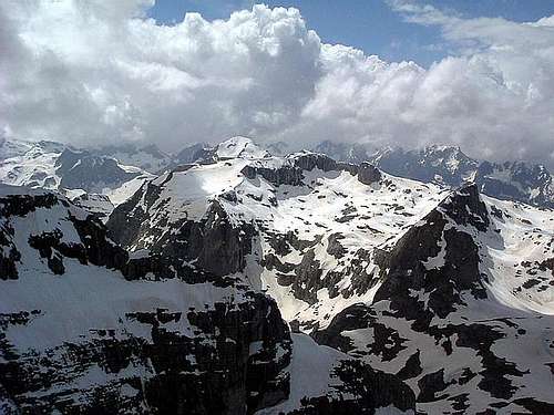
Ocnjak (Canine Tooth)

In Prokletije massif

Sunrise above Ropojana

Prokletije Landscape
Gateway to Prokletije and Karanfili peaks are Plav town and Gusinje town and Grbaja & Ropojana Valleys. Information how to get there:
By Plane
~To Beograd (Belgrade, Serbia&Montenegro capital) airport. Than with plane to Podgorica, capital of Montenegro, or with bus or car to Plav town.
~To Podgorica airport. Than with bus or car to Plav town and after to Gusinje town.
Information about flights find on the sites of JAT Airways, a former Yugoslav airlines, or on Montenegro Airlines.
By Bus
~Beograd (Belgrade)-Plav
~Podgorica-Plav
By train
~Beograd (Belgrade)-Bijelo Polje. Than with bus or with car (rent a car) to Plav and Gusinje.
By car
~Beograd (Belgrade)-Kraljevo-Novi Pazar-Plav-Gusinje.
~Podgorica-Kolasin-Andrijevica-Plav-Gusinje
Gusinje town and Plav town (in Montenegro) are the main destinations you would head first. In Gusinje you can buy everything (food, shampoo, soap, clothes,... and many other things), all what you need for few days of trekking and climbing in heart of Prokletije massif.
From Gusinje town you can go deeper in Prokletije massif through two valleys - Grbaja & Ropojana. Distance Gusinje - Grbaja valley: 7,5 km, (2 h of walking with big rucksack (backpack).
Also, from Gusinje town you can go to Ropojana valley, and farther across Montenegrin/Albanian border (with entry permit of albanian police) to center of Prokletije massif - Jezerski Vrh/Maja Jezerce/Lake Peak (2694 m) area.
 |
 |
 |
 |
Red Tape
You're in border country and will have to ask for military permits to visit certain (Albanian) parts of the range, where is highest peak of Prokletije massif - Jezerski Vrh/Maja Jezerce/Lake Peak (2694 m) and beautiful Lake Valley with few glacier lakes. At hotels you can get information about the permits required. But there always destinations that are reachable without any permits.
 |
 |
 |
 |
 |
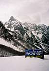
When To Climb
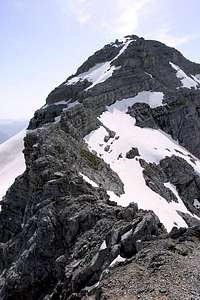
Albanian Prokletije

In Grbaja Valley

View to Karanfili
If you're interested in backpacking, June through September are the best month to do so. In June and July also, you will find snow area on some places, specialy on north side of massif. Don't worry, snow is hard. Like in many mountains, you will find full lakes from April till July. If you want to make a photos of lakes, better come in this period. Jun or July is the best for this. If you will come earlyer, take with you everything from mountain equippment, which you will need for example in winter or spring time. Also, late summer and autumn offer a variety of fruit you will be easy picking while ascending some ridges like wild plums, raspberries and blueberries.
If you're not afraid of winter conditions you could learn about the special attire of life in a remote mountain region.
Towns like Andrijevica or Gusinje are like ferry tale towns when snow is covering the ridges around and you sit in one of the restaurants drink boza (traditional lemonade) or eat hot burek and watch the local markets. Also, you have chance to bye milk products from local people of Prokletije area.
 |
 |
 |
 |
 |
Camping
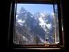
 Through the window of Branko Kotlajic Hut in Grbaja Valley
Optimal place for stay and camping in the Montenegrin part of Prokletije range are "Branko Kotlajic" Hut and "Karanfili" Hut, both placed in Grbaja Valley. The owner of "Branko Kotlajic" Hut is "Radnicki" Mountain Club from Belgrade/Serbia). Exist possibility for getting a key of that hut and stay there. Information: e-mail: info@pd-radnicki.rs, www.pd-radnicki.rs . The owner of "Karanfili" Hut is "Karanfili" Mountain Club from Gusinje town.
Also, exist some chance to make a deal with shepherds who offer a place in their huts. Try it and let yourself be surprised. Most of the wayside restaurants can offer accomodations over night, you just have to ask "prenociste". Camping is not allowed but not controlled regularly.

"Branko Kotlajic" Hut
Also, you can rent rooms in Plav and Gusinje towns and stay there. For orientation - from Gusinje till Grbaja valley is 7 km distance. By car - 10 minutes, by walk with big rucksack - 2 hours.
Also, in Ropojana valley (Montenegrin part of Prokletije) you can find mountain hut "Ropojanski Zastan" (belong to Montenegrin border police).
 |
 |
 |
 |
 |
Mountain Conditions
The best local weather forecast (4 times daily) for Prokletije (Plav town) on VREME YUBC NET
 |
 |
 |
 |
 |
External Links
The Web site of Mountaineering Club PSD PROKLETIJE PLAV is very good place to see many beautifully photo galleries from many beautifully ascents and adventures in Montenegrin and Albanian part of PROKLETIJE range. This web site offer you possibility to discover many parts, valleys and peaks of Prokletije.