
|
|
Mountain/Rock |
|---|---|
|
|
47.53430°N / 13.27220°E |
|
|
7509 ft / 2289 m |
|
|
Overview
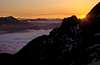
During winter for many people Scheiblingkogel is the last exhausting obstacle when crossing the vast karstic plateau of the Tennengebirge from south to north. But Scheiblingkogel is also a very rewarding peak when being climbed from the north, from the village of Scheffau. Three impressive cirques called Wies (in the east), Schwer (in the center) and Roeth (in the west) are the most prominent features offering three beautiful posibilities for ascending or descending. But due to the long ascent (vertical distance 1800m) it is not so often ascended from the north. The most popular route from the north leads through the Schwer, where a marked path runs from the Rossberghut to the summit.
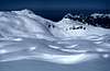
Wies and Roeth are very rarely visited as there exist no paths. During winter when the danger of avalanches is not too high Scheiblingkogel offers great skiing possibilities through the afore mentioned cirques.
Climbing Scheiblingkogel requires a good physical condition but no special climbing skills as long as you stay on the marked path. Take enough water with you (especially if you plan to cross the plateau), you won´t find any springs up there. This fact is characteristic for the whole Tennengebirge and the other large karstic plateaus of the northern Alps like Steinernes Meer, Hagengebirge, Dachstein, Totes Gebirge or Hochschwab. All water immediately disappears into cracks and vertical caves. Some of these caves like the more than 1200m deep Berger cave (that hides in the Schwer) belong to the deepest cave systems in the world.
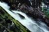
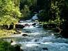
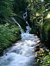
The waters that dissappeared in the huge plateau areas emerge close to the valley forming giant springs and breathtaking waterfalls. At the base of Scheiblingkogel the largest spring of the Tennengebirge and one of the largest springs in Central Europe, the Winnerfall, is situated. During snow melt about 15.000 liters per second of crystal clear water leave the mountain.
 |  |  |  |  |
Getting There
The Tennengebirge is situated about 25km south of Salzburg City. Salzburg has an international airport and is connected to the transnational railway and motorway net.
The villages around the Tennengebirge can be reached by public transports like busses (Scheffau, Abtenau, Annaberg-Lungötz, St. Martin) or by bus and train (Golling, Tenneck, Werfen, Hüttau).
To get to the base of Scheiblingkogel take the bus from Golling (leaves at the railway station) or if you go by car leave the motorway at Golling and drive into the Lammer valley to Oberscheffau. At Oberscheffau the Lammeröfen, a fantastic gorge, are worth visiting. The ascent to the Scheiblingkogel starts near the gorge at a small inn called Engelhartswirt that awaits you when you return from the mountain thirsty and hungry .
Red Tape
No permits are required and no fees to be paid
When To Climb
Scheiblingkogel can be climbed all year round
In winter the best conditions usually are from February to Mid-April. In summer June, September and October are best. In July and August the weather might be rather hot and unstable with severe thunderstorms in the Tennengebirge. Take care of vertical caves covered by dwarf-pines or snow. Now and then people (mostly skiers) disappear in those karstic areas and in some cases were discovered by speleologists decades later.
Skiing
In winter Scheiblingkogel is climbed from the south (last culmination when crossing the plateau of the Tennengebirge)and from the north but all ski runs go down to Scheffau in the north. The most popular run is via Schwer down to Oberscheffau. The routes via Wies and Röth are also very promising but more difficult as you have to bypass some dangerous walls. Skiing down requires stable snow conditions as some of the slopes are rather steep.
 |  |  |  |  |
Tennengebirge Traverse
In winter the Tennengebirge can be traversed from north to south by ski in only one day. Be sure that the weather conditions are stable as orientation can be very difficult on the plateau. Distance from Werfenweng to Oberscheffau is approximately 18km.
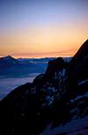
Starting point is the small village of Werfenweng high above the Salzach valley. A cable car to the Bischlinghöhe may reduce the ascent by 600m. Soon the Heinrich Hackel Hut is passed and the Tauernscharte, the first gate to the plateau region will be the next target. After the Tauernscharte the summit of the Eiskogel may be climbed. A short downhill leads to the next ascent, the Schubbühel which represents the second gate to the large plateau of the Tennengebirge. From there almost endless ups and downs (more downs) lead into a huge karstic depression the Tiefe Gruben between Scheiblingkogel and Bleikogel. Here the last ascent to the Scheiblingkogel starts.
 |  |  |  |
Camping And Accomodation
Till now there are no camping restrictions for Tennengebirge. Almost at the base of Scheiblingkogel the Rossberg Hut (985m) is situated.
Happisch Hut and Edelweiss Hut are in quite a distance to Scheiblingkogel. For more information see the SP Tennengebirge page. Around the Tennengebirge it is easy to find B&B or hotels to a reasonable price.
 |  |  |
Mountain Conditions
There are no websites with up to date conditions info or live cams as far as I know.
Giant Springs and Waterfalls
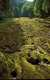
As mentioned above the Tennengebirge is an outstanding example for limestone karst. Some of the deepest caves in the world with a vertical extension of more than 1000m and some of the longest caves of Austria (more than 40km) - far from beeing completely explored - transsect this mountain range. Through caves and shafts all of the precipitation is transported downwards. In stratigraphically deeper units dolomite which is not that affected by corrosion occurs. These dolomite layers which are much less permeable for water are generally inclined to the north(-east) so that the boundary between the karstic limestones and the dolomites can be found in a height of up to 1500m in the south while it is below the level of the valley in the north.
As a consequence all major springs can be found at the northern side of the Tennengebirge.
The largest one is the origin of the Schwarzbach ("Black River") near Oberscheffau. Other large springs are the Infang Wasserloch ("Infang Waterhole") near Unterscheffau / Kuchlbach and the springs of Dachser and Tricklfall near Abtenau. Much of the karstic waters directly discharge into the aquifer of the Lammer valley. At the northern tip of the Tennengebirge the river that is flowing through the Brunnecker cave directly discharges into the Salzach river (somewhere below the water surface).
Most of the year these springs show only a small amount of water (except Schwarzbach) or are even dry but still a substantial amount of water discharges into the highly permeable gravels of the Lammer valley.
During snow melt or after longer raining periods the water table within the mountain rises and the giant springs are becoming active. In total an area of about 120km² is being dewaterd underground re-appearing in a few springs. Within one year about 200.000.000.000 litres of water are taking this way (this is about 30 litres for each human being on earth!). Most of this water comes out in May forming powerful waterfalls. The more astonishing is that these waterfalls have not been discovered by tourism yet (fortunately). A few examples are shown below.
 ..
..  ..
..  ..
.. 
 |  |  |  |
Caves
Scheiblingkogel contains a large number of caves (mostly vertical caves). The deepest one, the Schwer cave system, has a vertical drop of about 1300m.
At the mountain base sevral large springs occur. After snow melt has finished, when most of these springs have run dry, it is possible to enter the cave systems behind.
 |  |  |  |  |
Scheiblingkogel As Seen From Apart
 |  |