
|
|
Mountain/Rock |
|---|---|
|
|
37.94710°N / 107.3976°W |
|
|
Hinsdale |
|
|
Spring, Summer, Fall, Winter |
|
|
13832 ft / 4216 m |
|
|
PT 13,832 & PT 13,811 Overview
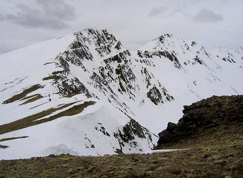 PT 13,832
PT 13,832 and PT 13,811 are the only members of the highest hundred peaks in Colorado with neither an official nor unofficial name. These two centennial thirteeners (ranked #91 & #99 respectively) are located just east of the 14,000-foot peaks Redcloud and Sunshine near Lake City. Despite their proximity to three of the most popular San Juan 14ers, these peaks can grant you total solitude amidst the beautiful San Juan Mountains. They offer long ascents with signficant elevation gain from the south and the west, but otherwise pose no real difficulties to those who choose to climb them. Their rugged north and northwest faces may surprise those lulled by the peaks' otherwise gentle demeanor. These two summits are the easiest of the San Juans' centennial thirteeners to pursue during the snow season because of excellent access. Even during the height of winter, the Cinnamon Pass Road typically remains open up to and beyond the Williams Creek Trailhead.
These unnamed peaks and their surroundings are located within a large parcel of BLM (Bureau of Land Management) land near Lake City. I've never seen the reason why alpine terrain – typically the domain of the US Forest Service in Colorado – in this area is managed by the BLM. The peaks are provided a modicum of protection due to their location within the BLM's Redcloud Wilderness Study Area. Only the permanent protection afforded by official wilderness status will eliminate the threats posed by mining interests, vividly demonstrated by a failed 1983 plan to lop the top 1500' off gorgeous Red Mountain, a peak at the end of the long ridge that extends east from the summit of PT 13,811. The primary reason that wilderness designation has stalled here is because of mineral wealth associated with the Lake City Caldera, including deposits of alunite in Red Mountain. In 2004, 832 & 811 were "protected" from being named when the USGS turned down a proposal to christen them after two of Colorado's mountaineering pioneers, Carl Blaurock and Bill Ervin. Apparently the policy is to not approve new names of mountains within wilderness or wilderness study lands, and a competing Blaurock/Ervin naming proposal was selected for a pair of peaks in the central Sawatch Range.
Getting There
Please refer to the Williams Creek Trailhead page for driving directions.Silver Creek Trailhead: This trailhead provides access to the Southwest Ridge route. To get to the Silver Creek Trailhead, follow the Cinnamon Pass Road for a total of 16 miles from SH-149. The parking available here is more generous than at the Williams Creek TH, but the Silver Creek TH is much busier because it provides access to three 14ers. The round-trip distance and elevation gain for this climb is approx. 9.3 miles and 3500'. If you decide to continue to PT 13,811, this will add 2.8 miles and 1350' to your trip because you have to resummit PT 13,832 during your return hike.
Access to PT 13,811 is also available via the Alpine Gulch Trailhead from the Henson Creek Road. Please refer to Gerry Roach's 13ers guide for more information on this approach.
Red Tape
These two peaks are located on the BLM's Redcloud Wilderness Study Area, so typical wilderness restrictions apply. Contact the BLM's managing office, the San Juans Public Lands Center (970.247.4874) in Durango, for the latest information on any restrictions.Leave No Trace suggests you observe these principles when traveling and camping in all public lands, especially wilderness:
1. Plan Ahead and Prepare
2. Travel and Camp on Durable Surfaces
3. Dispose of Waste Properly
4. Leave What You Find
5. Minimize Campfire Impacts
6. Respect Wildlife
7. Be Considerate of Other Visitors
When To Climb
While these peaks are most easily climbed during the summer months, the Williams Creek Trailhead is usually accessible year-round, and is your best bet for a winter or spring attempt. Almost the entire route above treeline is climbed on south-facing ridges, lessening the potential for avalanche danger. The Cinnamon Pass Road is typically plowed before Memorial Day weekend (in 2005, it was plowed all the way to the 12,220' pass by May 5), after which the Silver Creek Trailhead becomes accessible.Camping
Camping is permitted within the Redcloud Wilderness Study Area.Mountain Conditions
For current conditions, the BLM's district office in Durango is likely too far removed to be of any real use. You'll probably have more luck contacting some of the Jeep rental businesses in Lake City, who'll know whether the Cinnamon Pass Road has been plowed and may have been out recently enough to give you an idea of the snowpack's condition.For weather information, the National Weather Service is a good place to start:
UN 13,832 experimental point forecast