
|
|
Mountain/Rock |
|---|---|
|
|
44.97220°N / 70.3264°W |
|
|
4049 ft / 1234 m |
|
|
Overview
Mount Abraham (or Abram according to some locals) is located in western Maine, northwest of the Town of Kingfield. The upper reaches of the summit are unusually bare and the mountain is easily recognizable based on this feature alone. The ridge of Abraham extends for nearly 4.5 miles and ranges in elevation from 3400 to over 4000 feet.The most common route to Abraham's open summit is the Fire Warden's Trail. This trail approaches from the northeast and grades are gradual for the first 3 miles, at which point the trail enters a clearing where the abandoned Fire Warden's cabin is located. From here the trail turns left (south) and climbs steeply up for a mile where it comes out on an old slide. From this point on the trail is completely exposed and caution should be taken if bad weather is threatening. Cairns are small and may be hard to follow if visibility is low. The trail continues to rise steadily through a boulder field to the summit and an abandoned Maine Forest Service tower. From the summit, the Mount Abraham Side Trail leaves to the northwest and meets the Appalachian Trail in approximately 1.5 miles.
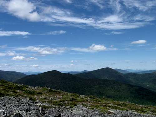
View north from the summit.
According to the Maine Bureau of Parks and Lands, Mount Abraham's alpine zone totals approximately 350 acres. This expansive alpine zone is the second largest in Maine... only Katahdin has more. The entire ridgeline and most of the eastern and northern slopes have recently been conserved thanks to the efforts of many groups including the Maine Appalachian Trail Land Trust.
 |  |  |
Getting There
Follow ME-27 north from Farmington into Kingfield. After passing through the center of town, turn left onto West Kingfield Street. The pavement ends approximately 3 miles from ME-27. Continue straight through a cross roads at 3.5 miles. Six miles from ME-27, turn left and cross two bridges over Rapid Stream. After crossing Rapid Stream, keep to the right. The Fire Warden's Trailhead is 1/2 mile beyond the bridges.Red Tape
No fees or permits are required. The entire summit and most of the northern and eastern slopes are managed by the Maine Bureau of Parks and Lands (BPL) as the 6,629 acre Mount Abraham Unit. Of the 6,000 plus acres in the unit, 5,377 acres are managed as an ecological reserve. The Maine BPL have recently completed a 10 year management plan for the Flagstaff Region, which contains the Mount Abraham Unit. It is available for download here.Access is provided in part via private logging roads. Drivers should use caution as logging trucks always have the right of way. The two bridges over Rapid Stream may be difficult to cross with a low clearance vehicle.
When To Climb
The mountain can be climbed during any season, but as is often the case in Maine, unplowed access roads can make for a long day in the winter. Also, the cairns marking the trail above treeline are very small and may not be visible after a heavy snow event or in low visibilty conditions. Care should be taken to note your path as you ascend so that you can descend safely to treeline. |  |  |
Camping
While there aren't any designated camping areas on the mountain, camping is not prohibited. The abandoned Fire Warden's cabin is often used as a shelter, and the surrounding area is level enough for primitive camping. According to the Maine Mountain Guide (8th edition), there is a good spring to the right of the cabin.Additionally, the Mount Abraham side trail leaves northwest from the summit and joins with the AT in approximately 1.5 miles. Travel north along the AT for an additional mile to reach the Spaulding Mountain Lean-To.
 |
Mountain Conditions
As with any exposed summit in New England, the weather can be unpredictable. Mount Abraham rises 3,000 feet from the surrounding valleys and conditions on the summit can vary greatly from those at the trailhead. The best place for up to date trail conditions is www.viewsfromthetop.com.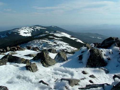
October snow.

Iron Hiker - Jun 26, 2016 1:36 pm - Hasn't voted
Bridges replacedI climbed Mount Abraham on 6/25/2016 and the two formerly washed-out bridges over Rapid Stream have now been replaced, so you can drive right to the trailhead once again. It seems this happened sometime last year. The new bridges are in excellent condition and any vehicle can navigate them.
injektilo - Jul 9, 2016 9:17 am - Hasn't voted
Re: Bridges replacedThanks for the reminder to update this! I was there in December and the bridges were replaced then. I just forgot to change the text back. Should be good to go now. Thanks again.