
-
 16968 Hits
-
 90.69% Score
-
 34 Votes
|
|
Mountain/Rock |
|---|---|
|
|
45.87030°N / 7.49250°E |
|
|
Mountaineering |
|
|
11496 ft / 3504 m |
|
|
Overview
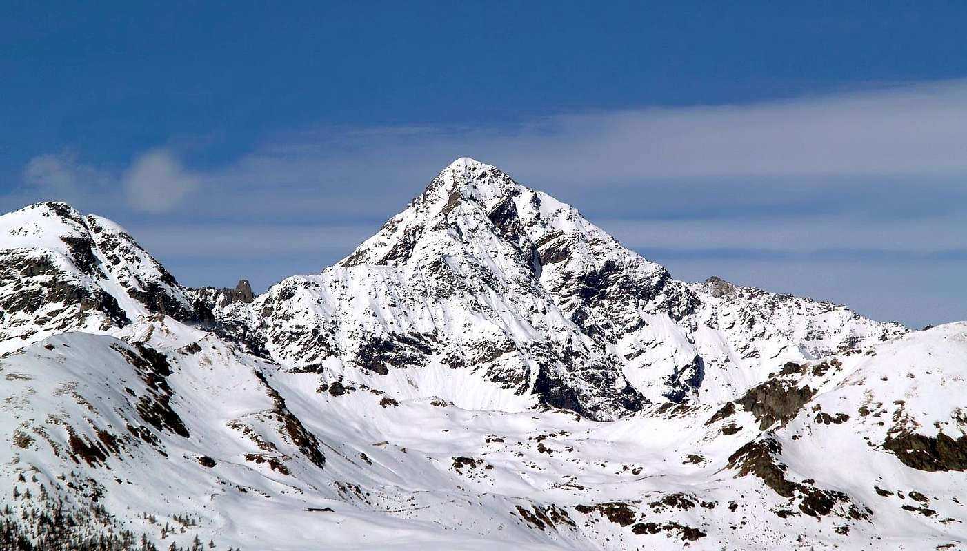
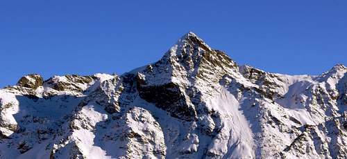
Smart mountain with a perfect pyramidal look, all its sides look fine, the North side is partially covered by the homonymous glacier. In the year 1952 a huge landslide came down, from about 3.200m on the WSW face, destroying the Houses and the Stables of Creusset and Arbière, the Village of Chamen and killing some people.
Elegante montagna dall'aspetto perfettamente piramidale con eleganti linee da tutti i suoi versanti, il lato Nord è parzialmente ricoperto dall'omonimo ghiacciaio. Nell'anno 1952 la montagna fu teatro di una enorme frana di roccia e ghiaccio che si staccò dalla parete O-SO a quota 3.200 metri, distruggendo gli Alpeggi di Creusset e d'Arbière e il Villaggio di Chamen causando alcune vittime.
First Ascents
- First ascent (from Luseney Glacier): A. Adams Reilly, Jean Antoine Carrel and Henry Charlet, (Aug 02th, 1866).
- First in winter: Giuseppe Fillietroz and Lorenzo Rosset, (Dec 26th, 1935).
- E-NE Wall (direct route:) Felice Mondini and Louis d'Antoine Bich, (Aug 16 th, 1892).
- N Wall (super direct route): Osvaldo Cardellina, Marco Cossard, Camillo Roberto Ferronato and Giuseppe Lamazzi, (Aug 15th, 1984).
- E-NE Arête: E. A. Martelli, Jean Antoine Carrel and Joseph Maquignaz, (Aug 01th, 1874).
- E Wall and E Arête: Martino Baretti, A. Oberti, Jean Baptiste and Jean Joseph Maquignaz, (Aug 02th, 1892).
- S-E Arête: Mario Borelli, Pietro Costantino and Sergio Noel, (Nov 27th, 1921).
- S-E Couloir and S-E Arête: Aldo Bonacossa and Benedetto Salvi Cristiani, (May 07th, 1919).
- S Arête: E. Gabutti, Mario Schiagno and Cirillo Favre, (Aug 16th, 1919) in descent.
- S Arête: Rino Rossi and Cirillo Favre, (Aug 21th, 1923) in ascent.
- W Wall and N-NW Arête: Pantaleone Bovet and Joseph Henry, (Jun 21th, 1904).
- N Arête: Umberto Balestreri, Erminio Piantanida, Nino Quaini and Mario Rezza, (Jul 28th, 1924).
 |
 |
 |
Getting There
BY CAR:- From Torino, Milano, etc: Motorway A5. Exit at Nus.
- From Switzerland: through the Grand Saint Bernard Tunnel or the namesake pass.
- From France: through Mont Blanc Tunnel or Petit Saint Bernard Pass. It isn't necessary to take Motorway A5: you can drive on SS.26, in the direction of Aosta.
- Aeroporto "Corrado Gex" Saint Christophe (Aosta).
Route
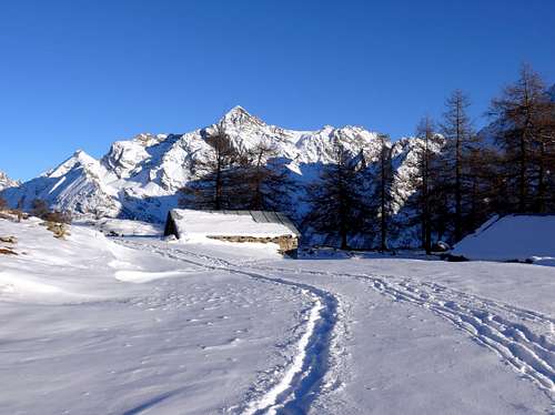
First day: From the Pastures of Praz (1.737m), got ascending along the Valley of Saint Barthélemy till the fork for Lignan (1.633m) where you must take the branch on the right side. Along the farm road, overcome the Pastures of Vallorsière (1.900m) and Champlaisant (1.902m), forward along the Saint Barthélemy Stream up to the end of the valley and the Houses of Les Crottes (2.389m), here turn to the left to ascend the steep slopes getting the plain where, near the lake, you can find the new Bivouac Luca Reboulaz (2.560m). Take into account that once in a year (on the 5th of August) the unpaved road is open to the cars on the occasion of the procession towards the Cuney Oratory. Therefore one can take advantage of the opportunity and reach a fork near Ollière(2.000m);from here, instead of going left towards Cuney, continue straight arriving at the "Luca Reboulaz" Bivouac, near the Luseney Lake(2.574m), in about an hour and a half. (info from Livioz)Primo giorno: Dall'Alpeggio di Praz (1.737 m) che si raggiunge risalendo il Vallone di Saint Barthélemy sino al bivio per Lignan (1633 m), dove si svolta sulla destra, proseguire lungo la strada poderale; oltrepassare gli Alpeggi di Vallorsière (1.900 m) e Champlaisant (1.902 m). Continuare lungo il Torrente Saint Barthélemy sino alle testata della valle, dove sorgono le Baite di Les Crottes (2.389 m); da questo punto voltare progressivamente sulla sinistra e superare il ripido pendio che porta al ripiano, dove nei pressi del lago sorge il nuovo Bivacco Luca Reboulaz (2.560 m) con 24 posti letto.
Second day: From the bivouac go round on the right side of the Luseney Lake and ascend to the basin leading to a notch (almost always snow here). Following some tracks climb the steep snow slopes leading to the Luseney Pass (3.162m). On along the steep N side of the mountain bordering the rocks of the NE ridge till it joins with the East ridge and, exposed part you get the summit.
Secondo giorno: Dal bivacco aggirare sul lato destro il Lago di Luseney; salire la conca che conduce a un colletto quasi sempre nevoso. Su tracce di sentiero superare i ripidi nevai che portano al Colle di Luseney (3.162 m). Salire il ripido versante Settentrionale costeggiando le rocce della cresta Nord-Est sino alla confluenza con la cresta Est dalla quale con poca fatica si perviene alla vetta. Tratto finale esposto con roccia friabile.
Difficulty
The route can be rated AD-.
L'ininerario è classificato AD-.
Campings
Remember that free camping is forbidden (except for emergency reasons, over 2.500m, from darkness until dawn).Mountain Condition
- Meteo: you can find all the needed informations at the official site of the Valle d'Aosta Region:
- Valle d'Aosta Meteo
Webcam
- WEBCAM on Aosta Valley:
- Webcam
Books and Maps
BOOKS:- "Guida della Valpelline" de l'Abbè Joseph-Marie Henry - Societè Editrice Valdotaine 1925 II Edition e Collana Reprint Musumeci (1986).
- "Guida dei Monti d'Italia" Alpi Pennine (Vol. 2) di Gino Buscaini - Club Alpino Italiano/Turing Club Italiano, Luglio 1970 (In Italian).
- "Dove andiamo in montagna? in Valle d'Aosta" di Domenico Caresio Edit. Tipografia Ferraro Ivrea, Marzo 1996.
- "Diari Alpinistici" di Osvaldo Cardellina e Indice Generale accompagnato da Schedario Relazioni Ascensioni 1964-2019 (unpublished).
- "80 itinerari di Escursionismo Alpinismo e Sci Alpinismo in Valle d'Aosta", di Osvaldo Cardellina, Ed. Musumeci, Giugno 1977 (in Italian); seconda Ed. Luglio 1981; terza Ed. Luglio 1984; (in French), prima Ed. Febbraio 1978; seconda Ed. Marzo 1980.
 |
 |
- Kompass - Breuil/Cervinia - Zermatt - Carta turistica 1:50.000.
- I.G.C. Istituto Geografico Centrale "La Valpelline" (carta n° 115) Map1:30.000.
- I.G.M. Istituto Geografico Militare - Map1:25.000.
- L'Escursionista Ed. Rimini "Gran San Bernardo-Ollomont (carta n° 5) 1: 25.000.
Important Information
- REGIONE AUTONOMA VALLE D'AOSTA the official site.
- FONDAZIONE MONTAGNA SICURA Villa Cameron, località Villard de la Palud n° 1 Courmayeur (AO) Tel: 39 0165 897602 - Fax: 39 0165 897647.
- SOCIETA' DELLE GUIDE DELLA VALPELLINE Etroubles-Strada Nazionale, n° 13 - Tel +39 0165 78559 - Valpelline-Loc Capoluogo, n° 1 - Tel +39 0165 713502 (AO) Italia.
- A.I.NE.VA. (Associazione Interregionale Neve e Valanghe).
Useful numbers
- Protezione Civile Valdostana località Aeroporto n° 7/A Saint Christophe (Ao) Tel. 0165-238222.
- Bollettino Valanghe Tel. 0165-776300.
- Bollettino Meteo Tel. 0165-44113.
- Unità Operativa di Soccorso Sanitario Tel. 118.
livioz - Dec 17, 2005 8:02 pm - Voted 10/10
Untitled CommentTake into account that once in a year (on the 5th of August) the unpaved road is open to the cars on the occasion of the procession towards the Cuney Oratory.
Therefore one can take advantage of the opportunity and reach a fork near Ollière (2000 m); from here, instead of going left towards Cuney, continue straight arriving at the "Luca Reboulaz" Bivouac, near the Luseney lake (2574 m), in about an hour and a half.
livioz - Dec 17, 2005 8:21 pm - Voted 10/10
Untitled CommentA further map:
La Valpelline - escursioni
Istituto Geografico Centrale - 1:30000
Claude Mauguier - Nov 14, 2005 8:43 am - Hasn't voted
Untitled CommentThe only comfortable spot to rest during a winter or summer ascent is bivacco luca reboulaz . This unwarded hut replaces the old bivouac "Franco Nebbiai", a little wooden structure which offered room for only 4 persons.
This hut asks a 3/4 hours walk from the hamlet of Praz, which belongs to the common of Lignan, within St Barthélémy. Left bank of Aosta valley, about 12 km east from Aosta, turning left once one reaches the village of Nus
Claude Mauguier - Nov 14, 2005 8:46 am - Hasn't voted
Untitled Commentbivouac Reboulaz
Claude Mauguier - Nov 14, 2005 3:52 pm - Hasn't voted
Untitled CommentEssential title : Alpi Pennine, vol.II, from the "Guida dei Monti d'Italia" series, published by CAI/TCI in 1970 (in italian)
The Swiss 1:50000 , sheet "Valpelline" map may be used, unless more accurate and detailed material may be found hereafter or in some good Aosta bookshop.
livioz - Dec 17, 2005 8:02 pm - Voted 10/10
Untitled CommentTake into account that once in a year (on the 5th of August) the unpaved road is open to the cars on the occasion of the procession towards the Cuney Oratory.
Therefore one can take advantage of the opportunity and reach a fork near Ollière (2000 m); from here, instead of going left towards Cuney, continue straight arriving at the "Luca Reboulaz" Bivouac, near the Luseney lake (2574 m), in about an hour and a half.
livioz - Dec 17, 2005 8:21 pm - Voted 10/10
Untitled CommentA further map:
La Valpelline - escursioni
Istituto Geografico Centrale - 1:30000