
-
 74376 Hits
-
 95.82% Score
-
 55 Votes
|
|
Mountain/Rock |
|---|---|
|
|
47.38300°N / 113.918°W |
|
|
Mountaineering, Scrambling, Skiing |
|
|
Spring, Fall, Winter |
|
|
9820 ft / 2993 m |
|
|
A Stunning Mountain!
 The next time someone asks why I climb, I'll show them this photo.

 These beautiful green slopes are nice to look at; hell to traverse!
McDonald Peak is the highest, most dominant peak in the incomparable Mission Range of northwestern Montana. In a range of spectacular summits, McDonald Peak lords over all with its sheer bulk and cloud-scraping height. Plainly and equally arresting from either the Mission Valley to the west or the Swan Valley to the east, the mountain's appeal is unmistakable—and unavoidable—for anyone living or passing within sight of it.
The Missions are big mountains—the southern half of the range the more so, courtesy of a Continental Ice Sheet riding up and over the range's northern portion, grinding those summits to a somewhat more diminutive status than the lofty southern giants, which were subjected to serious hacking and carving, but not actually buried by the ice (there are still several relatively small, but respectable, glaciers in the Missions, including McDonald Glacier on the peak's north face). All the major peaks in the Southern Missions involve elevation gains in the vicinity of 6,000 feet, and if you are careless in your approach to McDonald (such as, from the west, not taking Red Horn Lane all the way to its end—and you'll need something a bit higher and tougher than a passenger car to do so), you could well end up climbing considerably closer to 7,000 feet than 6,000 (and even that's assuming you traverse above the Ashley Lakes...but more on that later)!
The crux of most any McDonald climb lies in the approach. The Missions receive copious precipitation that nourishes not only a deep, long-lasting snowpack on the peaks, but a dense jungle of vegetation below the snowline. There is no trail up this big mountain, and getting to treeline is 3/4ths the battle. There are approaches from both east and west that, to a certain extent, minimize the bushwhacking below treeline, but be warned—this peak, from any direction, under any conditions, at any time, is a lot of work.
 Not by any means an easy country....
Summit Views....
Rather than trying to intersperse these shots throughout the text, I thought it might be nice to have a section of nothing but (mostly) summit pictures. Information continues in the next section; meanwhile, without further comment—enjoy!
 Not far below the summit, looking west, out on the Mission Valley.

 South from the summit—July.
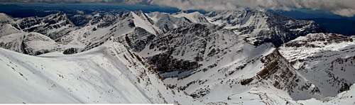 Panorama, south from the summit—winter.
, and the broad Mission Valley.")
, then Peak 8881, and farthest out is Mount Calowahcan (9061')")
, Glacier and Mountaineer Peaks (far right)—ridge dominating the foreground is part of McDonald.")
Getting There
FROM THE WEST
It is relatively easy reaching the "trailhead" for this climb.
But....

The problem is that "trailhead" is in quotes—there is nothing resembling a trail, even on the approach, for this mountain. Actually, I take that back; there is a trail from where you park, which leads (about four miles) to Ashley Lakes. You can do that if you wish, thus beginning the bushwhack at the lakes (the Ashley Lakes are two not large glacial tarns separated by a small natural dam—the upper lake being the larger—and are occasionally referred to in the singular, as "Ashley Lake"). There are, however, several problems with that approach: first, you've gained substantial elevation driving, and you'll lose it long before reaching the lakes.
Second, the trail is in the Mission Mountain Tribal Wilderness, which is managed for wilderness, not useage, and is only cleared every two or three years—meaning there are more obstacles along the way than on a trail maintained by the USFS—sometimes the deadfall and mud holes are quite time consuming!

Thirdly, upon reaching Ashley Lakes the trail ends, you have reached the beginning of your bushwhack...and a nightmare of climbing through, around, under, and over a substantial alder thicket! When we climbed McDonald, due to an injury to one of our party on descent (see Minor Epic on McDonald Peak), we made the decision to eliminate as much non-trail work as possible, descending to the Ashley Lakes so as to take advantage of the trail, which we knew would take us back to our vehicle. In that circumstance it was probably the right decision, but oh my goodness, that alder thicket was AWFUL!
The best solution, and what we managed on our ascent, is to ignore the trail, traverse approximately a thousand feet above the lakes, eventually dropping down to join Ashley Creek, but only after having passed the waterfall (see picture—climbing from the lakes up the waterfall is a very difficult, time-consuming, piece of manuevering; I've been told it's technical, but can't actually vouch for the accuracy of that statement). More on all this in the actual route.So...four miles north of St. Ignatius, head east on Red Horn Lane (NOT the Ashley Lakes road, which is three miles north of St. Ignatius—that is, one mile south of the just-mentioned Red Horn Lane).
Do not veer from this eastern heading; keep going straight, eventually crossing a canal, eventually going from pavement to gravel, eventually going through a probably closed gate (close gate behind you!), and soon the road begins to deteriorate. Stay on the road (ignoring any signs such as "Dead End Road"—which, of course, it eventually is), which begins to meander a bit, and also begins a steady climb. You'll need an SUV, pickup, or Jeep for comfortable progress—by off-roading standards this one is not bad, but I definitely wouldn't take a passenger car. It is approximately six miles to road's end, where there is limited space for parking—and camping, if you choose. You're where you need to be for a western assault on McDonald Peak. (As a matter of information, this is also a common starting point for climbing West McDonald Peak—although the routes diverge within a quarter mile or so.)
Route Page, McDonald Peak from the west (Mission Valley) side.
FROM THE EAST

(Note that this "from the east" section was written by mr kieran, the page's original maintainer. The description seems excellent, and, not having climbed McDonald from the east, I've left it just as written. See also his Southwest Face Route page.)
From the east (Swan Valley) side, the most expedient approach is via the Glacier Lake Trail. To reach the Glacier Lake Trailhead—the Mission Range's most popular trailhead—take Highway 83 north from Seeley Lake about 25 miles or south from Swan Lake about 30 miles and turn onto the Kraft Creek Road, which is actually about midway between those two points. From the north, it's just past the Hungry Bear Steakhouse, which I heartily recommend. The trailhead is about 15 miles from the turnoff (just follow the trailhead signs) and has a pit toilet and register.

To reach the base of the peak, you must first cross over the Mission divide above Island Lake, and this involves a substantial amount of bushwhacking between Heart Lake (the end of the officially maintained trail) and the outlet of Island Lake, 7 miles from the trailhead. From Island, a primitive (but mostly visible) trail climbs to the prominent Post Creek Saddle, which acts as the boundary between the Mission Mountains Wilderness (USFS) and the Mission Mountains Tribal Wilderness (Flathead Reservation). The area beyond is all encompassed by the Grizzly Bear Conservation Zone (see RED TAPE). You also get your first view of McDonald Peak since leaving the highway, and if you happen to be here after July 15 and before Oct 1, this a great spot to sit, eat lunch, and take in the view, 'cause this is as far as you're going.
From here (assuming the Conservation Zone isn't closed), you must immediately lose 600 or so feet of elevation to drop to Cliff Lake, aiming for the outlet which must be forded. The trail is fairly obvious from the divide to the lake, but it is steep, steep, steep. To access the southwest side of McDonald, which offers the safest line of ascent, you must work your way up the basin and around the prominent south buttress of the peak to the Ashley Creek Divide just above Icefloe Lake. Lots of steep beargrass slopes and broken cliffs make just getting to the base of the real climb pretty challenging. After all that, the ascent is a cinch. Total approach distance from the Glacier Lake Trailhead is around 12 miles. You'll gain over 6,000 feet of elevation during the course of this venture.
Red Tape, Cautions, & Wildlife
"Very early on a July morning as dawn warms this ancient peak and the snowfields take on a pink glow, grizzly bears begin to frolic in the freedom of summer. Damn big and nonchalant they stand, sniffing the air. They then lumber up the slopes to snack on ladybugs and army cutworm moths. After leisurely grubbing through rocks for these seasonal delicacies, the bears begin to overheat as the sun beats down on their thick fur. Since every summer day in the mountains is like a day off from work, the larger bears round up the cubs, and together amble up to the summit snowfields to cool off and have fun, lolling about in the drowsy afternoon hours, from time to time taking a whimsical glance at a good-size chunk of the Western Hemisphere. As the pleasures of the day envelope them, these bears take on a sporting attitude, romping about on slush and loose shale until finally, overwhelmed by exuberance, they take off for the lower elevations, hurtling down steep snowfields at a full gallop, paws slashing out avalanches of slush while long claws serve as crampons. Once off the snow they disappear into lengthening shadows of evening at timberline. These patrols are repeated until September when insect food is no longer found, and the beasts head into the valleys."
That marvelous paragraph comes from the now out-of-print Climbers Guide to Montana, by Pat Caffrey, and while in the book it serves as a lead-in to McDonald Peak and the summer grizzly closure restrictions in that particular area (see below), it also is quite relevant as an overall cautionary introduction to the wildlife inhabiting the entirety of this wild mountain range. Grizzlies live here in abundance, leading to some very unusual—and important—particulars pertaining to venturing onto and up McDonald Peak....The summit of McDonald is unique for a special reason: it is frequented by large numbers of grizzly bears who dine on the vast collection of ladybugs and cutworm moths present during the summer months. In the interest of reducing conflicts and providing the bears with some much-needed "time off," the Salish-Kootenai—who own the Flathead Reservation—close off the land surrounding the peak from July 15 through September 30. This does not mean you can still go in with a permit. It means that no mammal that walks erect, uses tools, and communicates with spoken language is allowed in the area within this time period.

If you still want to give it a go before or after the closure dates, you must possess a Flathead Reservation recreation permit simply to be in the area, with a camping stamp affixed if you wish to spend the night within the Tribal Wilderness. Permits are available at sporting goods stores throughout the region, and cost is $8.00 for a three-day permit, or $15.00 for a full-year permit (the full-year license expires the last day of February, no matter the month it was obtained), and may be purchased throughout Western Montana wherever hunting and fishing licenses are sold. Camping/overnight permits are extra, but not, of course, necessary if you are doing McDonald in a single day (and good luck with that particular bit of machismo!). For more info on closures or obtaining a permit, you can call the Tribal Recreation Office in Pablo: (406) 675-2700.
If approaching McDonald Peak from the east, to the best of my knowledge there are no unusual restrictions or regulations in the Mission Mountains Wilderness beyond that which exist in all federally designated wilderness areas. Trails and access are generally a bit "better" than in the neighboring Tribal Wilderness (some of these trails—not using game paths as their source—actually have switchbacks!), and permits are not required to camp alongside lakes, or in the backcountry. For information on the very different management philosophies and styles of the Mission Mountain Tribal Wilderness and the Mission Mountain Wilderness, this link will take you to the Mission Range page.
WILDLIFE

Probably anyone prone to climbing in this part of the country already knows this, but the Northern Rockies are full of wildlife, and considerations should be the same as for Glacier National Park. Always be aware, and don't do anything stupid, like—for example—leave food where bears can get at it, think that a mountain lion is even remotely related to your pet cat, or run up to a moose (moose are quite unpredictable, irritable, and very dangerous). And never, ever, EVER forget you're in grizzly country [an excellent, informative link!]; they insist on being left alone—disagreement on that point is not an argument you'll win! Bear spray and noise should be part of every foray you make into the back country. Black bears will be found in the forests, grizzlies commonly venture onto the above-timberline tundra, sometimes, when in pursuit of such delicacies as ladybugs or cutworm moth larva, even to the summits (see McDonald Peak Grizzly Closure information above)!
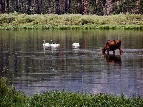
In addition to the wildlife already mentioned, the Missions are home to elk, Canadian lynx, bobcat, deer, wolves, the occasional grumpy wolverine (all wolverines are grumpy—it's a rule with them), badgers, martens, innumerable rodents large and small, both bald and golden eagles, osprey, and loons (over 50 different species of birds!), and flowers. And to top it all off, in the spring of 2005, a pair of trumpeter swans took up residence on the Mission's eastern flank, nesting on one of the Seeley-Swan Valley's many lakes. The female was killed when she flew into power lines, but the male raised the cygnets, and the fervent hope is that the family will return each summer—trumpeter swans are wonderful!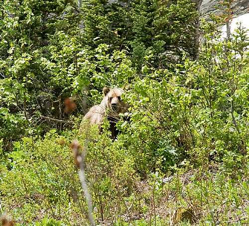
When To Climb, & Necessary Equipment
Despite the imposition of the Tribal closure, early July and early October can both be good times to attempt the peak (for what it's worth, I've never had good luck with October weather, although I'm willing to admit it may just be a run of bad luck—July weather is much better!). The peak is still really snowpacked early in the season (in fact, year-round), but this can work to your advantage since the snow covers up a lot of loose, grungy talus. At the very least, an ice axe is mandatory, and crampons are a good idea as well. We climbed the mountain July 2nd following a relatively mild winter, and could not have done so without the protection of ice axes—don't even consider it! Crampons were not quite the absolute necessity of ice axes, but we made use of them, and were only too glad to have them. Don't mess with this peak, make both ice axe and crampons standard equipment!
Camping
If climbing via an eastern approach, the best place to camp is probably Cliff Lake, but getting in and out with a heavy pack can be a trial. You can look and look higher up the drainage but pickins is kinda' slim. Also, you need to have a Tribal recreation permit with camping stamp attached (see "Red Tape" section above for particulars). If you don't mind losing 800 feet right away on summit day (and gaining it back on the way out), you might camp in the meadows below the Post Creek Saddle.
Keep in mind, McDonald has been climbed in one day, car to car, from the Glacier Lake Trailhead. Now that's hardcore.
In Tribute
On March 1, 2011, Vernon Garner, Saintgrizzly, left us after losing a bold, inspiring fight against pancreatic cancer. Or maybe he won, for he is at last free of his pain and has "shuffle[d] off this mortal coil."Vernon was an important contributor on SummitPost, but beyond merely making good, informative pages, he actually inspired many who read his work. No one put more work into his or her pages than Vernon did, and many of those pages, especially those related to Glacier National Park, the place he loved above all others, are works of art in both the writing and layout. More than one person has wanted to visit Glacier or go back to Glacier largely due to what he shared about that magnificent place.Many people on SP counted Vernon among their friends, and many more saw him as one of the best, one of those who exemplified the spirit of this site. He was one of the best of us, he will be missed, and he will not be forgotten.As a tribute to him, Vernon's pages will remain in his name. Any member who sees a need for an addition or correction should please contact site management via the "Send PM to the Elves" feature.Rest well and climb on, Vernon.